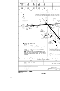


CYYT - St. John's Intl
Located in St. John's, Canada
ICAO - CYYT, IATA - YYT
Data provided by AirmateGeneral information
Coordinates: N47°37'7" W52°45'9"
Elevation is 461 feet MSL.
Magnetic variation is -17.0811° East View others Airports in Newfoundland and Labrador
Operational data
Special qualification required
Current time UTC:
Current local time:
Weather
METAR: CYYT 080600Z 28004KT 15SM BKN003 OVC018 06/06 A2943 RMK SF7SC1 VIS W-N 2 SLP972
TAF: TAF CYYT 080540Z 0806/0906 28004KT 6SM BR BKN004 OVC015 TEMPO 0806/0811 2SM -DZ -SHRA BR OVC002 FM081100 27012KT 2SM -RA BR OVC003 TEMPO 0811/0813 6SM -SHRA BR OVC004 FM081300 30012KT 6SM -SHRA BR SCT004 BKN012 FM081600 33015KT P6SM -SHRA FEW006 BKN015 FM081700 35015G25KT 6SM -DZ BR BKN006 OVC012 FM082300 32012KT 6SM BR BKN006 BKN012 BECMG 0823/0901 29008KT RMK NXT FCST BY 081200Z
Communications frequencies: [VIEW]
Runways:
| RWY identifier | QFU | Length (ft) | Width (ft) | Surface | LDA (ft) |
| 10 | 86° | 8502 | 200 | ASPH | 8502 |
| 28 | 266° | 8502 | 200 | ASPH | 8502 |
| 16 | 139° | 7005 | 200 | ASPH | 7005 |
| 34 | 319° | 7005 | 200 | ASPH | 7005 |
Airport contact information
Address: St. John's Canada