


ESNN - Sundsvall-Timra
Located in Sundsvall, Sweden
ICAO - ESNN, IATA - SDL
Data provided by AirmateGeneral information
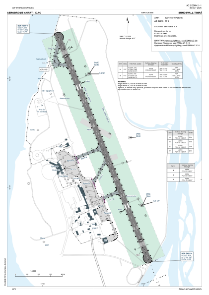
Coordinates: N62°31'46" E17°26'34"
Elevation is 17 feet MSL.
Magnetic variation is +7.0° East View others Airports in Västernorrlands län
Operational data
Special qualification required
Current time UTC:
Current local time:
Weather
METAR: ESNN 281220Z 13008KT 110V170 9999 FEW011 BKN110 BKN220 04/01 Q1023
TAF: TAF ESNN 281130Z 2812/2821 32005KT 9999 -RA BKN009 PROB40 2816/2818 2000 -SN BKN004
Communications frequencies: [VIEW]
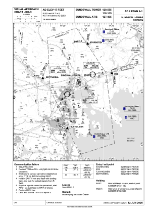
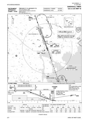
Runways:
| RWY identifier | QFU | Length (ft) | Width (ft) | Surface | LDA (ft) |
| 16 | 160° | 6411 | 148 | ASPH | 5919 |
| 34 | 340° | 6411 | 148 | ASPH | 5919 |
Airport contact information
Address: Sundsvall Sweden
Other aviation service providers
Aviation club (not for profit)

Sundsvalls Segelflygklubb
Sundsvalls Segelflygklubb
info@sundsvallssegelflygklubb.se+4669110800
+46703704720
+46703704720