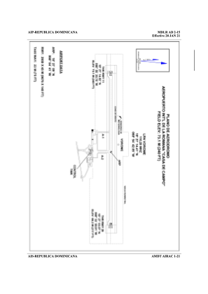


MDLR - Casa De Campo La Romana Intl
Located in La Romana, Dominican Republic
ICAO - MDLR, IATA - LRM
Data provided by AirmateGeneral information
Coordinates: N18°27'9" W68°54'41"
Elevation is 240 feet MSL.
View others Airports in La Romana Province
Operational data
Special qualification required
Current time UTC:
Current local time:
Weather
TAF: TAF MDLR 220400Z 2206/2306 00000KT 9999 SCT018 SCT070 PROB30 2206/2212 7000 -TSRA FEW016CB BKN018 SCT070 BECMG 2213/2215 15010KT
Communications frequencies: [VIEW]
Runways:
| RWY identifier | QFU | Length (ft) | Width (ft) | Surface | LDA (ft) |
| 11 | 97° | 9678 | 148 | ASP | |
| 29 | 277° | 9678 | 148 | ASP |
Airport contact information
Address: La Romana Dominican Republic