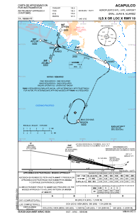
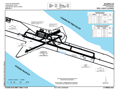


MMAA - Acapulco Aeropuerto Internacional Gral. Juan N. Alvarez
Located in Acapulco, Mexico
ICAO - MMAA, IATA - ACA
Data provided by AirmateGeneral information
Coordinates: N16°45'26" W99°45'14"
Elevation is 16 feet MSL.
View others Airports in Guerrero
Operational data
Special qualification required
Current time UTC:
Current local time:
Weather
METAR: MMAA 281348Z 33005KT 7SM SKC 26/22 A2984 RMK HZY
TAF: TAF MMAA 281036Z 2812/2912 03005KT 5SM HZ SCT020 SCT300 TX30/2819Z TN24/2812Z FM281800 23010KT P6SM SCT020 FM290300 03005KT 5SM HZ SCT020 SCT300
Communications frequencies: [VIEW]
Runways:
| RWY identifier | QFU | Length (ft) | Width (ft) | Surface | LDA (ft) |
| 10 | 108° | 10827 | 148 | CON | |
| 28 | 288° | 10827 | 148 | CON | |
| 06 | 67° | 5577 | 115 | CON | |
| 24 | 247° | 5577 | 115 | CON |
Airport contact information
Address: Acapulco Mexico