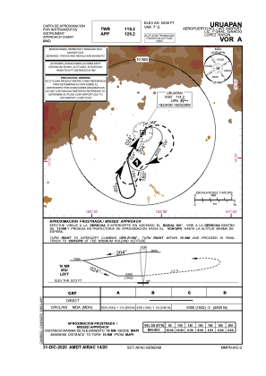
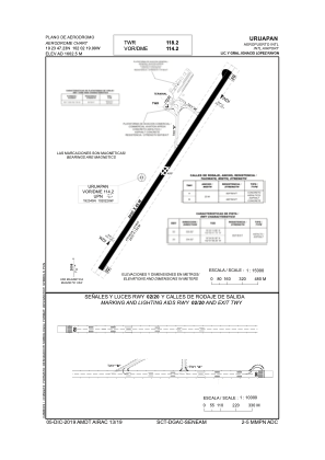


MMPN - Uruapan Aeropuerto Nacional Lic. Y Gral. Ignacio Lopez Rayon
Located in Uruapan, Mexico
ICAO - MMPN, IATA - UPN
Data provided by AirmateGeneral information
Coordinates: N19°23'47" W102°2'20"
Elevation is 5258 feet MSL.
View others Airports in Michoacin
Operational data
Special qualification required
Current time UTC:
Current local time:
Weather
METAR: MMPN 220040Z 00000KT 11SM FEW070 SCT310 28/17 A3005 RMK 8/031 HZY SC
TAF: TAF MMPN 211706Z 2118/2218 18005KT 5SM HZ SCT320 FM212100 20012KT P6SM SKC FM220300 00000KT 6SM HZ SKC
Communications frequencies: [VIEW]
Runways:
| RWY identifier | QFU | Length (ft) | Width (ft) | Surface | LDA (ft) |
| 02 | 32° | 7874 | 148 | ASP | |
| 20 | 212° | 7874 | 148 | ASP |
Airport contact information
Address: Uruapan Mexico