


NFTF - Fuaamotu
Located in Nukualofa, Tonga
ICAO - NFTF, IATA - TBU
Data provided by AirmateGeneral information
Coordinates: S21°14'31" W175°8'26"
Elevation is 129 feet MSL.
Magnetic variation is +14° East View others Airports in Tongatapu
Operational data
Special qualification required
Current time UTC:
Current local time:
Communications frequencies: [VIEW]
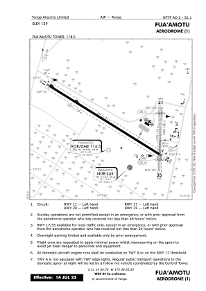
Runways:
| RWY identifier | QFU | Length (ft) | Width (ft) | Surface | LDA (ft) |
| 11 | 122° | 8763 | 148 | ASPH | |
| 29 | 302° | 8763 | 148 | ASPH | |
| 17 | 182° | 4921 | 98 | GRASS | |
| 35 | 2° | 4921 | 98 | GRASS |
Airport contact information
Address: Nukualofa Tonga