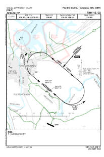
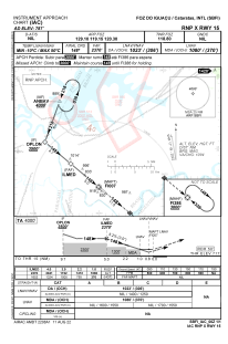
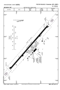


SBFI - Cataratas
Located in Foz Do Iguaçu, Brazil
ICAO - SBFI, IATA - IGU
Data provided by AirmateGeneral information
Coordinates: S25°36'1" W54°29'6"
Elevation is 787 feet MSL.
Magnetic variation is -16.944385853° East View others Airports in Paraná
Operational data
Special qualification required
Current time UTC:
Current local time:
Weather
METAR: SBFI 042300Z 17004KT 9999 FEW030 26/25 Q1012
TAF: TAF SBFI 042100Z 0500/0524 36005KT 9999 SCT020 TN22/0509Z TX30/0518Z PROB40 0500/0508 2000 BR BKN004 BECMG 0513/0515 02008KT CAVOK RMK PFQ
Communications frequencies: [VIEW]
Runways:
| RWY identifier | QFU | Length (ft) | Width (ft) | Surface | LDA (ft) |
| 15 | 131° | 7154 | 146 | ASPH | |
| 33 | 311° | 7154 | 146 | ASPH |
Airport contact information
Address: Foz Do Iguaçu Brazil