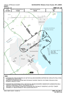
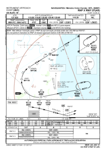
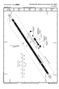


SBNF - Ministro Victor Konder
Located in Navegantes, Brazil
ICAO - SBNF, IATA - NVT
Data provided by AirmateGeneral information
Coordinates: S26°52'43" W48°39'3"
Elevation is 18 feet MSL.
Magnetic variation is -19.956193089° East View others Airports in Santa Catarina
Operational data
Special qualification required
Current time UTC:
Current local time:
Weather
METAR: SBNF 060800Z 30003KT 9000 SCT012 BKN016 23/22 Q1015
TAF: TAF SBNF 060300Z 0606/0706 28005KT 2000 BR BKN006 TN22/0609Z TX28/0617Z TEMPO 0608/0610 0500 FG BKN002 FM061300 07007KT 8000 FEW030 FM070300 28005KT 2000 BR BKN008 RMK PFD
Communications frequencies: [VIEW]
Runways:
| RWY identifier | QFU | Length (ft) | Width (ft) | Surface | LDA (ft) |
| 07 | 56° | 5974 | 919 | ASPH | |
| 25 | 236° | 5974 | 919 | ASPH |
Airport contact information
Address: Navegantes Brazil