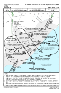
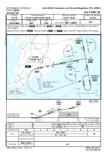
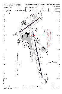


SBSV - Deputado Luis Eduardo Magalhaes
Located in Salvador, Brazil
ICAO - SBSV, IATA - SSA
Data provided by AirmateGeneral information
Coordinates: S12°54'31" W38°19'21"
Elevation is 65 feet MSL.
Magnetic variation is -23.230682334° East View others Airports in Bahia
Operational data
Special qualification required
Current time UTC:
Current local time:
Weather
METAR: SBSV 081400Z 15013KT 9999 SCT025 30/24 Q1015
TAF: TAF SBSV 0818/0918 12013KT 9999 SCT025 FEW027TCU TN26/0908Z TX31/0916Z BECMG 0818/0820 VCSH SCT023 FEW025TCU BECMG 0821/0824 NSW SCT023 BECMG 0903/0906 SCT016 FEW023TCU BECMG 0909/0912 VCSH SCT015 FEW020TCU BECMG 0913/0916 NSW SCT025 TEMPO 0916/0918 SCT025 FEW027TCU RMK PHH
Communications frequencies: [VIEW]
Runways:
| RWY identifier | QFU | Length (ft) | Width (ft) | Surface | LDA (ft) |
| 10 | 78° | 10246 | 919 | ASPH | |
| 28 | 258° | 10246 | 919 | ASPH | |
| 17 | 144° | 5374 | 492 | ASPH | |
| 35 | 324° | 5374 | 492 | ASPH |
Airport contact information
Address: Salvador Brazil