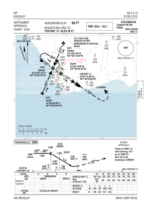
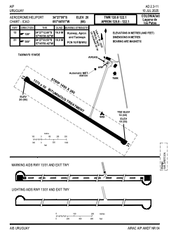


SUCA - Colonia /International Laguna De Los Patos
Located in Colonia, Uruguay
ICAO - SUCA, IATA - CYR
Data provided by AirmateGeneral information
Coordinates: S34°27'5" W57°46'1"
Elevation is 66 feet MSL.
View others Airports in Colonia
Operational data
Special qualification required
Current time UTC:
Current local time:
Weather
METAR: SUCA 061713Z 17006KT 3000 MIFG BR FEW005 BKN013 19/18 Q1005
TAF: TAF SUCA 061715Z 0618/0718 15005KT 9999 BKN008 BKN070 TX20/0718Z TN16/0710Z TEMPO 0618/0622 3000 DZ BR BKN008 OVC060 BECMG 0618/0622 0500 FG OVC002 PROB40 TEMPO 0714/0718 VRB15G25KT 2000 TSRA BR BKN006 FEW040CB OVC060
Communications frequencies: [VIEW]
Runways:
| RWY identifier | QFU | Length (ft) | Width (ft) | Surface | LDA (ft) |
| 13 | 118° | 4495 | 98 | UNK | |
| 31 | 298° | 4495 | 98 | UNK |
Airport contact information
Address: Colonia Uruguay