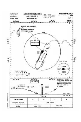
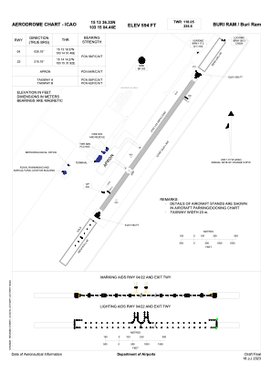


VTUO - Buri Ram / Buri Ram Airport
Located in Buri Ram, Thailand
ICAO - VTUO, IATA - BFV
Data provided by AirmateGeneral information
Coordinates: N15°13'36" E103°15'4"
Elevation is 590 feet MSL.
View others Airports in Buri Ram Province
Operational data
Special qualification required
Current time UTC:
Current local time:
Weather
METAR: VTUO 081000Z VRB02KT 9000 -RA SCT040 35/21 Q1007 NOSIG
TAF: TAF VTUO 080500Z 0806/0906 15005KT 8000 SCT035 BECMG 0811/0812 02005KT TEMPO 0817/0821 -TSRA FEW018CB BKN030 BECMG 0823/0824 11005KT
Communications frequencies: [VIEW]
Runways:
| RWY identifier | QFU | Length (ft) | Width (ft) | Surface | LDA (ft) |
| 04 | 35° | 6890 | 148 | ASP | |
| 22 | 215° | 6890 | 148 | ASP |
Airport contact information
Address: Buri Ram Thailand