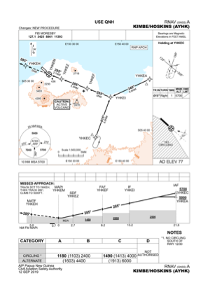


AYHK - Kimbe/Hoskins
Located in Hoskins, Papua New Guinea
ICAO - AYHK, IATA - HKN
Data provided by AirmateGeneral information
Coordinates: S5°28'0" E150°24'31"
Elevation is 98 feet MSL.
View others Airports in West New Britain
Operational data
Special qualification required
Current time UTC:
Current local time:
Weather at : - ( 0 km )
METAR: PABA 172033Z 00000KT 1 1/2SM BR OVC003 M03/M03 A3008 RMK AO2 VIS 3/4V3 UPB1954E03 FZRANO PNO $
Communications frequencies: [VIEW]
Runways:
| RWY identifier | QFU | Length (ft) | Width (ft) | Surface | LDA (ft) |
| 12 | 133° | 6234 | 98 | ASP | |
| 30 | 313° | 6234 | 98 | ASP |
Airport contact information
Address: Hoskins Papua New Guinea