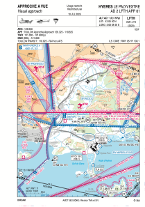


LFTH - Hyeres Le Palyvestre
Located in Hy, France
ICAO - LFTH, IATA - TLN
Data provided by AirmateGeneral information
Coordinates: N43°5'50" E6°8'46"
Elevation is 13 feet MSL.
Magnetic variation is 2.1424° East View others Airports in Provence-Alpes-Côte-d'Azur
Operational data
Special qualification required
Current time UTC:
Current local time:
Weather
METAR: LFTH 180530Z AUTO VRB02KT CAVOK 15/13 Q1012 BECMG 11012KT
TAF: TAF LFTH 180200Z 1803/1903 VRB03KT 6000 FEW014 SCT110 TEMPO 1803/1806 3000 BR BKN005 PROB40 TEMPO 1803/1806 0400 FG VV/// BECMG 1806/1809 11012KT SCT013 BECMG 1809/1811 CAVOK BECMG 1816/1818 VRB03KT PROB40 TEMPO 1900/1903 4000 BR
Communications frequencies: [VIEW]
Runways:
| RWY identifier | QFU | Length (ft) | Width (ft) | Surface | LDA (ft) |
| 05 | 51° | 6959 | 148 | CONC+ASPH | 6070 |
| 23 | 231° | 6959 | 148 | CONC+ASPH | 6762 |
| 13 | 135° | 5935 | 148 | CONC+ASPH | 5322 |
| 31 | 315° | 5935 | 148 | CONC+ASPH | 5531 |
Airport contact information
Address: Hy France

