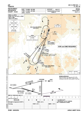
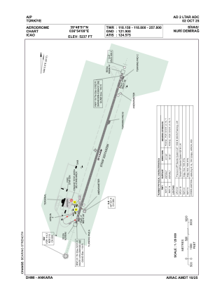


LTAR - Sivas Nuri Demirag
Located in Sivas, Turkey
ICAO - LTAR, IATA - VAS
Data provided by AirmateGeneral information
Coordinates: N39°48'51" E36°54'9"
Elevation is 5237 feet MSL.
Magnetic variation is 5.8° East View others Airports in Sivas
Operational data
Special qualification required
Current time UTC:
Current local time:
Weather
METAR: LTAR 061950Z 35010KT 8000 BKN001 BKN025 01/01 Q1016
TAF: TAF LTAR 061940Z 0621/0706 35008KT 8000 BKN005 BKN025 TEMPO 0621/0701 3500 -SNRA BR BKN001 BKN020 TEMPO 0701/0705 2000 BR BKN001 BKN020
Communications frequencies: [VIEW]
Runways:
| RWY identifier | QFU | Length (ft) | Width (ft) | Surface | LDA (ft) |
| 01 | 18° | 12503 | 148 | ASPH | 12503 |
| 19 | 198° | 12503 | 148 | ASPH | 12503 |
Airport contact information
Address: Sivas Turkey