


YGLB - Goulburn
Located in Goulburn, Australia
ICAO - YGLB, IATA - GUL
Data provided by AirmateGeneral information
Coordinates: S34°48'37" E149°43'35"
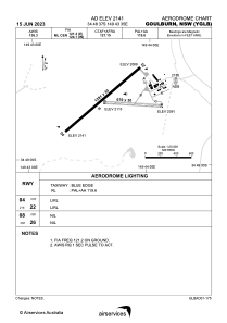
Elevation is 2141 feet MSL.
View others Airports in New South Wales
Operational data
Special qualification required
Current time UTC:
Current local time:
Weather at : YSCB - Canberra ( 73 km )
METAR: YSCB 070730Z AUTO 13009KT 9999 // OVC053 13/09 Q1030 RF00.0/000.0
TAF: TAF YSCB 070507Z 0706/0806 12007KT 9999 -SHRA SCT030 FM071000 13006KT 9999 NSW SCT020 TEMPO 0712/0723 9999 BKN018
Communications frequencies: [VIEW]
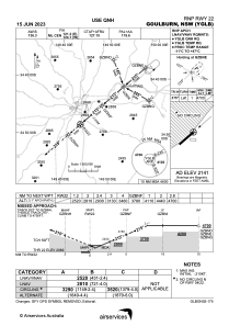
Runways:
| RWY identifier | QFU | Length (ft) | Width (ft) | Surface | LDA (ft) |
| 08 | 92° | 2228 | 98 | GRE | |
| 26 | 272° | 2228 | 98 | GRE | |
| 04 | 48° | 4203 | 98 | ASP | |
| 22 | 228° | 4203 | 98 | ASP |
Airport contact information
Address: Goulburn Australia
Other aviation service providers
Flight schools

Aviation club (not for profit)

Southern Tablelands Gliding Club
Southern Tablelands Gliding Club
president@stgc.org.au+61490064347
+61490064347
+61490064347