Tropical Storm Bret bears down on Caribbean islands, second storm developing behind
 Tropical Storm Bret and Tropical Depression Four on satellite imagery courtesy of NASA. Bret is the larger storm on the left and Four is the smaller storm on the right.
Tropical Storm Bret continues as a strong tropical storm with maximum sustained winds near 110 km/h, just shy of category one hurricane strength.
The storm will move across the Lesser Antilles, a group of islands on the eastern Caribbean Sea, Thursday evening.
St. Lucia is under both a tropical storm warning and a hurricane watch. A tropical storm warning is in effect for Martinique and Dominica and tropical storm watches extend to Barbados and St. Vincent.
Bret threatens parts of the islands with rain that could range 75 to 200 mm. Tropical storm force winds are a risk for those island under the warnings. Dangerous surf and rip tides are also expected upon and following the storms passage.
After passing through the island group, Bret is forecast to continue moving westward into the Caribbean Sea as a tropical storm on Friday.
 Tropical Storm Bret is forecast to cross the Lesser Antilles on Thursday evening.
To the east of Bret, Tropical Depression Four has developed.
The storm is forecast to continue to strengthen while moving northwestward into Friday. Once it reaches tropical storm strength it will be named Cindy. The system is forecast to move to a position east of the Bahamas by early next week as a tropical storm or tropical depression.
There is no imminent risk from either storm to the Maritimes or Atlantic Canada. The more northerly movement of Tropical Depression Four does mean we may need to watch the remnants of that system closely next week.
 Tropical Depression Four is likely to become Tropical Storm Cindy. The storm taking a northwestward path that will place it east of the Bahamas early next week.
The start of hurricane season has been unusually active in the tropical Atlantic. That area typically has more frequent development later in the season in late summer and early fall. A contributing factor is unusually warm Atlantic Ocean waters, much of the southern Atlantic is currently sitting one to three degrees above average.
The presence of these warmer waters and the favourable conditions they create for tropical storms and hurricanes was noted in the forecast for the hurricane season this year.
 Sea surface temperature anomaly courtesy of the National Atmospheric and Oceanic Administration. Much of the Atlantic is anomalously warm.


CTVNews.ca Top Stories

Man arrested after allegedly caught trespassing at Drake's Bridle Path mansion
Toronto police say a man has been taken into custody after he was allegedly caught trespassing at Drake's mansion in Bridle Path Saturday afternoon.
Wildfire that forced evacuation of Fort Nelson, B.C., caused by tree falling on wires, mayor says
The wildfire that prompted the evacuation of more than 3,000 people near Fort Nelson, B.C., was caused by a tree falling on wires, according to the municipality's mayor.
Eurovision Song Contest final kicks off after protests, backstage chaos and a contestant's expulsion
The 68th Eurovision Song Contest finally got down to musical business Saturday in the Swedish city of Malmo after days of protests and offstage drama that have tipped the feelgood musical celebration into a chaotic pressure cooker overshadowed by the war in Gaza.
Couple randomly attacked, 1 stabbed, by group of teens in Toronto, police say
A man has been transported to hospital after police say he was stabbed in a random attack carried out by a group of teens in Toronto on Friday night.
'I am angry': Alberta farmers will continue fight over world class motorsport resort
The rolling hills leading to the hamlet of Rosebud are dotted with sprawling farms and cattle pastures -- and a sign sporting a simple message: No Race Track.
IN PICTURES
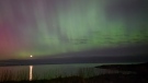
IN PICTURES Northern lights dance across the night sky in southern Ont.
From London, to Grand Bend, Collingwood and Guelph, here are some highlights of Friday night and Saturday morning's northern lights display.
Ron Ellis, who played over 1,000 games with Maple Leafs, dead at 79
Ron Ellis, who played over 1,000 games with the Toronto Maple Leafs and was a member of Canada's team at the 1972 Summit Series, has died at age 79.
opinion
opinion How to use your credit card as a powerful wealth-building tool
Irresponsibly using a credit card can land you in financial trouble, but personal finance columnist Christopher Liew says when used properly, it can be a powerful wealth-building tool that can help grow your credit profile and create new opportunities.
Which Canadian cities have the highest and lowest grocery prices?
Where you live plays a big factor in what you pay at the grocery store. And while it's no secret the same item may have a different price depending on the store, city or province, we wanted to see just how big the differences are, and why.
Shopping Trends
The Shopping Trends team is independent of the journalists at CTV News. We may earn a commission when you use our links to shop. Read about us.


Toronto
-
Man arrested after allegedly caught trespassing at Drake's Bridle Path mansion
Toronto police say a man has been taken into custody after he was allegedly caught trespassing at Drake's mansion in Bridle Path Saturday afternoon.
-
Ron Ellis, who played over 1,000 games with Maple Leafs, dead at 79
Ron Ellis, who played over 1,000 games with the Toronto Maple Leafs and was a member of Canada's team at the 1972 Summit Series, has died at age 79.
-
Missed the Northern Lights in Ontario? You may still have a chance
Those who missed the dazzling display of northern lights in Ontario may have another chance on Saturday – so long as the skies clear.
Calgary
-

'I am angry': Alberta farmers will continue fight over world class motorsport resort
The rolling hills leading to the hamlet of Rosebud are dotted with sprawling farms and cattle pastures -- and a sign sporting a simple message: No Race Track.
-
'We have laws': Premier Smith says police action justified in Calgary
The actions, including the decision to use non-lethal force, to disperse pro-Palestinian protesters from the University of Calgary campus were justified, Alberta Premier Danielle Smith said Friday.
-
Hundreds participate in Bum Run in northwest Calgary to raise money for colon cancer
More than 300 Calgarians laced up to run five kilometres to raise money and awareness for colon cancer Saturday.
Edmonton
-

Demonstrators descend on U of A after pro-Palestinian encampment cleared by police early Saturday morning
Several hours after after police forcefully removed a camp of pro-Palestinian demonstrators from the University of Alberta, hundreds of protesters marched from downtown toward the campus.
-
Grande Prairie County No. 1 under state of emergency, evacuation orders due to wildfire
Out-of-control wildfires in northern Alberta prompted a local state of emergency in the County of Grande Prairie early Saturday morning, as well as evacuation orders in the county and the Municipal District of Greenview.
-
Heavy smoke, poor air quality in Edmonton and area
A special air quality advisory was issued for the Edmonton area Saturday due to heavy wildfire smoke from northeast British Columbia.
Montreal
-

Cyclist issued fine for striking four-year-old girl crossing the street
A cyclist turned herself in and received a fine after striking a four-year-old girl who was crossing the street to catch a school bus.
-
IN PHOTOS
IN PHOTOS No blackouts reported as Quebecers take in spectacular solar storm
Quebecers across the province turned their gazes upwards on Friday night as a spectacular show in the sky was on display thanks to a solar storm hit the earth's atmosphere.
-
Ghost shoes installed to honour grandmother struck and killed on Montreal sidewalk
Dozens gathered on Lavoisier Boulevard in Ferland Park in Montreal on Saturday as a pair of white shoes were installed in memory of a mother and grandmother, who was struck and killed by an SUV almost four years ago in the St. Leonard borough.
Ottawa
-
 IN PHOTOS
IN PHOTOS Scenes of the northern lights dancing across eastern Ont.
A powerful geomagnetic storm lit up the night sky on Friday and early Saturday morning, resulting in an incredible light show across eastern Ontario.
-
Advocates call for better cycling infrastructure as NCC Weekend Bikedays begin
Ottawa cyclists took to the streets on Saturday in celebration of the National Capital Commission (NCC) kicking off Weekend Bikedays on city roads.
-
Residents, visitors take in opening ceremonies of the Canadian Tulip Festival
The rain did make a brief appearance on Saturday, but that didn't stop the large crowds from making their way to the Canadian Tulip Festival's opening weekend.
London
-
 IN PICTURES
IN PICTURES Northern lights dance across the night sky in southern Ont.
From London, to Grand Bend, Collingwood and Guelph, here are some highlights of Friday night and Saturday morning's northern lights display.
-
Conditions 'favourable' for development of funnel clouds in London, Ont. region, neighbouring counties
Conditions will be favourable for the development of funnel clouds in London and surrounding counties on Saturday, according to a weather advisory issued by Environment Canada.
-
'A look behind the scenes': Families get look at how London’s emergency services prepare
Hundreds of people braved the early morning rain to get up close with London, Ont.’s emergency service personnel. Children were excited to climb aboard emergency vehicles and participate in emergency-related activities.
Barrie
-

OPP Const. Greg Pierzchala Memorial Run returns to Barrie
Family, friends, colleagues and strangers set off on a fundraising run on Saturday, marked by the memory of a man killed in the line of duty.
-
One person killed, two injured in Innisfil crash
One person is dead after a two-vehicle crash in Innisfil Saturday morning.
-
South Simcoe Police hold Police Week open house
South Simcoe Police opened their doors to visitors on Saturday as the police force marked its annual Police Week initiative.
Northern Ontario
-
 WATCH
WATCHWATCH Dashcam video shows terrifying near-miss on two-lane northern Ontario highway
There were some scary moments for several people on a northern Ontario highway caught on video Thursday after a chain reaction following a truck fire.
-
Millions of Canadians have been exposed to potentially toxic chemicals, and they're not going anywhere
For decades, North Bay, Ontario's water supply has harboured chemicals associated with liver and developmental issues, cancer and complications with pregnancy. It's far from the only city with that problem.
-
Highway 144 partially closed due to crash north of Greater Sudbury
Few details are available, but the Ontario 511 Traveller Information Service is reporting Highway 144 is partially closed in the Cartier area, north of Greater Sudbury, near the Elboga Lake sign following a crash Saturday afternoon.
Kitchener
-

Top university football players face off at East-West Bowl in Waterloo, Ont.
Canada’s top university football athletes gathered on the gridiron Saturday to show off their skills in the East-West Bowl at the University of Waterloo.
-
Northern lights stun sky watchers in southwestern Ontario
A spectacular and colourful show lit up the night sky across southwestern Ontario on Friday night.
-
Funnel clouds could develop in parts of the province Saturday, Environment Canada says
People in southwestern Ontario could see some funnel clouds on Saturday.
Windsor
-
 VIDEO
VIDEOVIDEO Flavour? Heat? Pain? 'Heatseekers' share their keys to a great bottle of hot sauce
What do you look for in a good bottle of hot sauce? Sweet or smokey flavours? Or, perhaps, you're a 'glutton for punishment' — the words of one person in attendance at Windsor's 2nd annual Heatseeker Hot Sauce Festival.
-
Incest among charges laid against Windsor senior after alleged sexual assault of minor: Police
Windsor police officers have laid multiple charges against a 70-year-old man in connection with the alleged sexual assault of a minor.
-
The northern lights were visible across Windsor-Essex. Take a look
The most powerful geomagnetic storm in the past 20 years resulted in some awe-inspiring images captured by people all across Windsor-Essex.
Winnipeg
-

“These people share the same common goal’: Community groups celebrate unity in Winnipeg
Several community groups who work with the city’s vulnerable populations gathered downtown on Saturday for an event to celebrate the impact of their work on Winnipeg.
-
Wildfire near Flin Flon prompts evacuation order
Some homes and cottages north of Flin Flon, Man. are under an evacuation order because of a growing wildfire caused by drought conditions and high winds.
-
Man behind bars after high-speed pursuit through multiple cities and towns
A 36-year-old man is behind bars after leading police on a high-speed pursuit through Winnipeg, Selkirk, and other surrounding communities on Friday night.
Regina
-

IN PICTURES: Geomagnetic solar storm brings northern lights to southern Sask.
As a geomagnetic solar storm swept through Earth on Friday, people in southern Saskatchewan were able to experience a rare display of northern lights.
-
'It would change my life': Prince Albert singer vying for $1 million on Canada’s Got Talent final
Prince Albert singer Rebecca Strong is on the cusp of achieving a dream on Canada’s Got Talent as she stands among the final eight contestants.
-
Moose Jaw Warriors look ahead to Game 2 after securing win on Friday
The Moose Jaw Warriors are looking ahead to Game 2 in the WHL Championship Series on Saturday after securing a win against the Portland Winterhawks on Friday.
Saskatoon
-
IN PICTURES: Geomagnetic solar storm brings northern lights to southern Sask.
As a geomagnetic solar storm swept through Earth on Friday, people in southern Saskatchewan were able to experience a rare display of northern lights.
-
'It would change my life': Prince Albert singer vying for $1 million on Canada’s Got Talent final
Prince Albert singer Rebecca Strong is on the cusp of achieving a dream on Canada’s Got Talent as she stands among the final eight contestants.
-
RCMP investigating suspicious death on Saulteaux First Nation
Saskatchewan RCMP are investigating a suspicious death on Saulteaux First Nation.
Vancouver
-
 BREAKING
BREAKING 4th Indian national arrested, charged with murder of Hardeep Singh Nijjar
Homicide investigators in B.C. say murder charges have been laid against a fourth Indian national in connection to the killing of Sikh activist Hardeep Singh Nijjar outside a Surrey gurdwara last year.
-
Wildfire that forced evacuation of Fort Nelson, B.C., caused by tree falling on wires, mayor says
The wildfire that prompted the evacuation of more than 3,000 people near Fort Nelson, B.C., was caused by a tree falling on wires, according to the municipality's mayor.
-
Northern lights put on a show across B.C.
Like skywatchers across Canada, B.C. residents were treated to a dazzling display late Friday night and early Saturday morning.
Vancouver Island
-

Northern lights put on a show across B.C.
Like skywatchers across Canada, B.C. residents were treated to a dazzling display late Friday night and early Saturday morning.
-
Wildfire that forced evacuation of Fort Nelson, B.C., caused by tree falling on wires, mayor says
The wildfire that prompted the evacuation of more than 3,000 people near Fort Nelson, B.C., was caused by a tree falling on wires, according to the municipality's mayor.
-
Bouchard lifts Edmonton Oilers to 4-3 overtime win over Canucks in Game 2
Evan Bouchard scored 5:38 into overtime and the Edmonton Oilers bounced back for a 4-3 win over the Vancouver Canucks in the second round of the Stanley Cup playoffs on Friday.
Kelowna
-

Suspect fled in 2-door Fiat after convenience store robbery, Merritt RCMP say
A suspect is at large after robbing a convenience store at gunpoint in Merritt, B.C., Friday, according to local police.
-
Kamloops RCMP issue public warning about 2 men allegedly at centre of 'organized crime conflict'
After four targeted shootings in four days, Mounties in Kamloops are taking the unusual step of warning the public about two men they believe are likely to be targeted in future violent incidents.
-
Community mourns thousands of fish lost as B.C. drought risk looms again
Images of steelhead and trout flicker over long sheets of paper, brought to life in blue and green crayon rubbings by the thousands.


