Democratic Republic of Congo - 2 Democratic Republic of Congo Logistics Infrastructure
The Democratic Republic of Congo (DRC) faces what is probably the most daunting infrastructure challenge on the African continent. As a result of the conflict, networks have been seriously damaged or left to deteriorate, with about half of existing infrastructure assets in need of rehabilitation. Even before the conflict, the lack of basic infrastructure made it difficult to knit together the country’s disparate economic and population centers. The country’s vast geography, low population density, extensive forestlands, and crisscrossing rivers further complicate the development of infrastructure networks.
Since the return of peace, there have been promising signs. Notably, a privately funded global system for mobile communications (GSM) telephone network now provides a signal to two-thirds of the population at a reasonable cost. Significant external funding has been captured to rebuild the country’s tattered road network. And there has been an increase in domestic air routes served as well as a renewal of the aircraft fleet operated by private airlines only. The country is endowed with the largest hydropower resources in Africa, giving it the potential to not only meet its own energy demands very cost-effectively but to become the continent’s largest power exporter. Meanwhile, the country’s inland waterways can provide low-cost surface transport, with only relatively modest investments needed to improve navigability (To that effect, under a five year World Bank project reported to have started in 2010, around 10,000 new or replacement markings are being installed along the navigable section of the Lualaba River, mainly the section (Ubundu-Kindu (308 km) and Kongolo-Bukama (645 km) that complement the SNCC railroad network along the Lubumbashi-Kisangani Corridor.
Also included in the program are the Mogalo-Oubangui section of the Lua river (141 km) and the Businga-Mobeka section of the Mongala river (342 km) in the agricultural rich North-Western part of the country (Equateur Province) to improve both day and night time navigation.
As part of the activity, the hydrometric network is also under rehabilitation through the installation of scales and depth gauging sections. These interventions complement the waterway rehabilitation activities supported by the European Union (EU) through the 10th European Development Fund (EDF) and the Belgian Technical Cooperation (BTC) and improve the integration of the intermodal network with SNCC regarding the West-South Corridor and the South-North Corridor as outlined on the Map below:

Source: RVF, 2010
But much still remains to be done.
One of the DRC’s most urgent infrastructure challenges is to increase the generation of power and deliver it in a more cost-effective manner. Close to half the existing plants require refurbishment, and capacity must increase by 35 percent over the next decade just to meet domestic demand. Both road and rail infrastructure are in dilapidated condition, while the latter has also fallen into disuse. As the DRC embarks on a massive road investment program, an adequate financial and institutional basis will be essential to maintain the network going forward.
To rebuild the country and catch up with the rest of the developing world, the DRC needs to spend $5.3 billion a year over the next decade, or 75 percent of the 2006 GDP. Of this total, as much as $1.1 billion a year needs to be devoted to maintenance alone. Without increasing spending or improving efficiency, the DRC would take more than a century to redress the country’s infrastructure deficit. This is clearly an unacceptable outcome, and underscores the urgency of action in this area.
Democratic Republic of Congo - 2.1 Democratic Republic of Congo Port Assessment
Overview
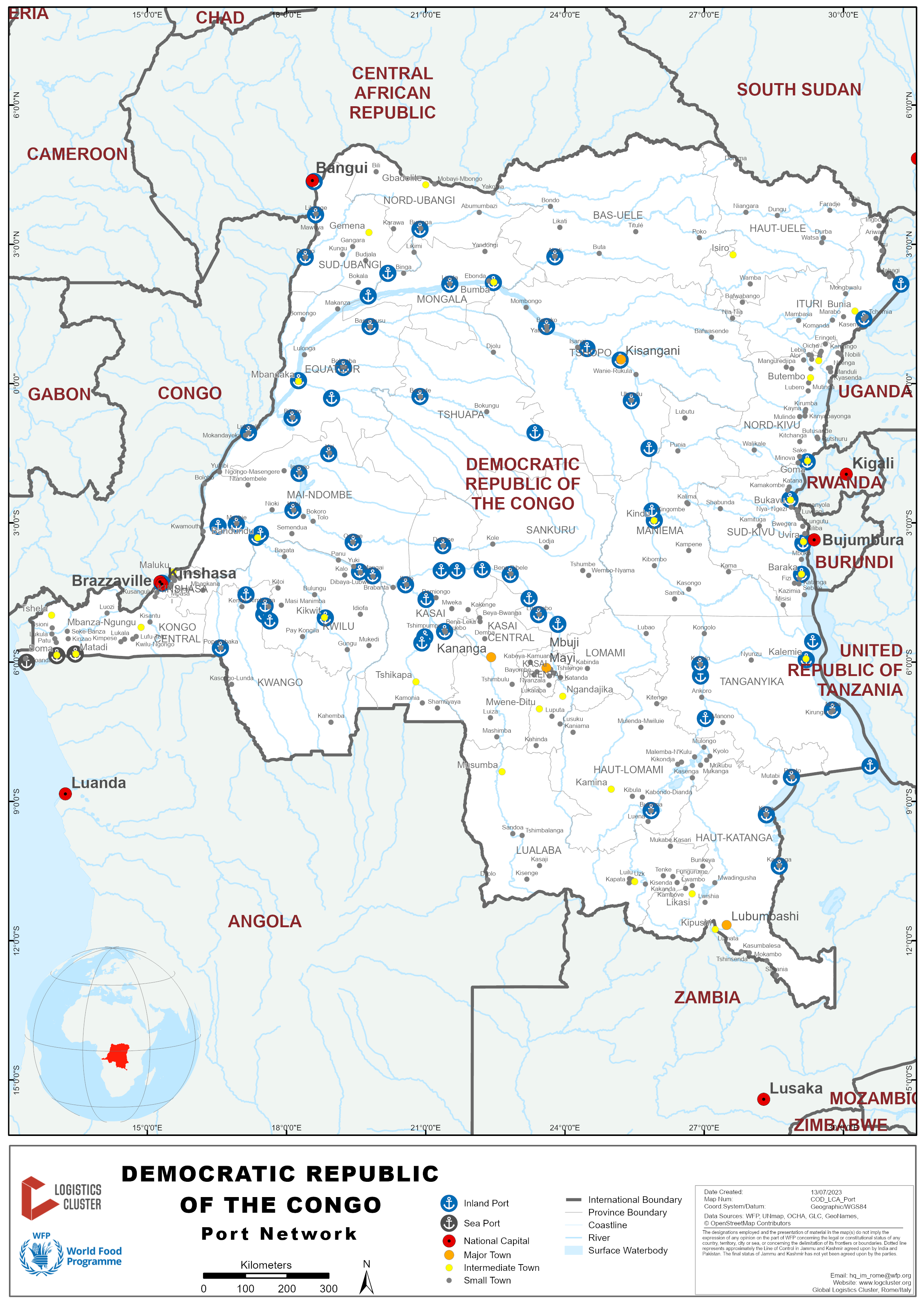
The maritime, river and lake network irrigates the entire country with 16,238 km of navigable waterways.The country has both inland ports and seaports that are interconnected with the rail and road networks. However, due to poor infrastructure conditions these networks remain inefficient.
The current situation is a serious drawback for the country to boost its local economy.
The country counts around forty rivers and lake ports (E.g., Kinshasa, Ilebo, Kalemie, Kisangani, Mbandaka, Ubundu, Kindu) and three seaports (Matadi, Boma and Banana).
Main corridors
-
The West corridor: Matadi Port (DRC) and Pointe Noire Port (Congo)
-
The Northern Corridor: Mombasa Port (Kenya) to the Great Lakes Region
-
The Central Corridor: Dar Es Salaam Port (Tanzania) to the Great Lakes Region
-
The Sud Corridor: from Kasumbalesa land border (Haut-Katanga), the DRC is connected to major ports in Southern Africa (Beira, Nacala, Durban, Walvis-Bay, Lobito et Luanda).
The Eastern DRC region counts several land border entries with Uganda, Rwanda, Burundi and Zambia that are alternative routes to supply from Mombasa and Der Es Salaam ports.

![]()

![]()
Ongoing projects 
Port of Banana (SCTP) Kongo Central
The Banana deep-water port's construction is the most important infrastructure project officially launched by the government last January 2022.
The future port will feature an initial 600-meter quay with an 18-meter draft, a container handling capacity of 450,000 TEUs and a 30-hectare yard to store containers. The $1.2 billion project will be built by a private operator with a target to complete a first phase in 2025.
As a result of a low draft approach in Matadi (8 m), only a few types of vessels can pass through (e.g., Panamax type with 4,000 TEU capacity maximum) and they require a transshipment in the port of Pointe Noire. Therefore, having a national deep-water port would result in more independent logistics as well as reduced transit costs. Furthermore, the government would also need to complete the 143 km train connection from Banana to Matadi to discharge cargo from the port as the road capacity is insufficient for future demand.
Although ports are partially controlled by the state-owned companies Société Commerciale des Transports et des Ports (SCTP) and Société Nationale des Chemins de fer du Congo (SNCC), they are now in competition with a multitude of private ports that emerged over the last years.
Private ports offer both passengers and/or cargo transportation with additional services such as storage, trucking and providing handling equipment (e.g., forklift, crane).

A privite port in Bukavu - Sud Kivu
Although private, the port stays under the control of the local authorities who control both passengers and/or cargo arrivals and departures. Authorities present are the following:
-
Direction Générale des Douanes et Accises (DGDA),
-
Office Congolais de Contrôle (OCC),
-
Direction Générale de Migration (DGM)
-
Programme National de l'Hygiène aux Frontières / Service de Quarantaine Animale et Végétale (PNHF/SQAV)
For information on Democratic Republic of Congo Port contact details, please see the following link: 4.4 Democratic Republic of Congo Port and Waterways Company Contact List.
Democratic Republic of Congo - 2.1.1 Democratic Republic of Congo Port of Matadi
Port Overview
The Matadi Port managed by SCTP (Société Commerciale des Transports et des Ports) is located on the left bank of the Congo River and 150 km upstream from the Atlantic Ocean. The port is 1,610 m long and fitted with 11 quays. Containers, general cargo and bulk are the main vessel types here. Matadi is the main import/export gateway of the West.
|
Port Location and Contact |
|
|---|---|
|
Country |
Democratic Republic of Congo |
|
Province or District |
Kongo Central |
|
Nearest Town or City with Distance from Port |
Matadi |
|
Port's Complete Name |
Port International de Matadi |
|
Latitude |
-5.826111 |
|
Longitude |
13.46917 |
|
Managing Company or Port Authority
|
SCTP (Société Commerciale des Transports et des Ports) |
|
Management Contact Person |
Directeur Technique : Daniel BULUNGIDI Délégué Commercial : Olivier MBU TSHIBUMGU |
|
Nearest Airport and Airlines with Frequent International Arrivals/Departures |
n/a |
Port Picture
 View of the Port of Matadi from the road to Boma


Description and Contacts of Key Companies
Most of the companies operating at SCTP Matadi Port are forwarding agents (E.g.GTM, Connexafrica, Amicongo) and trucking companies (e.g. NRJ, Afritrans, Sotraco).
CMA-CGM is the main shipping company serving the SCTP Matadi Port.
For more information on port contacts, please see the following link: 4.4 Port and Waterways Company Contact List and 4.8 Transporters Contact List.
Port Performance
SCTP Matadi Port is not deep enough to handle large vessels therefore the cargo needs to be transferred to feeder ships at neighboring ports. With the opening of the modern private MGT Matadi Port in 2016, the competitiveness of SCTP Matadi’s port declined. In 2022 the port captured 25% of the freight traffic.
|
Seasonal Constraints |
||
|---|---|---|
|
|
Occurs |
Time Frame |
|
Rainy Season |
Yes |
From October to May |
|
Major Import Campaigns |
No |
n/a |
|
Handling Figures for 2021 |
|
|---|---|
|
Vessel Calls |
243 |
|
Container Traffic (TEUs) |
58,943 |
|
Handling Figures Bulk and Break Bulk for 2021 |
|
|---|---|
|
Bulk (mt) |
1,724,017 |
|
Break bulk (mt) |
1,724,017 |
Berthing Specifications
|
Type of Berth |
Quantity |
Length (m) |
Maximum Draft (m) |
Comments |
|---|---|---|---|---|
|
Conventional |
4 |
626 |
8 |
Berths #1 and #2 are under rehabilitation |
|
Container |
3 |
524 |
8 |
Berths #5, #6 & #7 |
|
General and Mix |
3 |
460 |
8 |
Berths #8, #9 & #10 |
|
Silo Berth |
1 |
n/a |
n/a |
Berth #11 dedicated to the flour milling company MIDEMA |
|
Berthing Tugs Water Barges |
1 |
75 |
n/a |
|
General Cargo Handling Berths
|
Cargo Type |
Berth Identification |
|---|---|
|
Imports - Bagged Cargo |
Berths #3 and #4 |
|
Exports - Bagged Cargo |
|
|
Imports and Exports - RoRo |
n/a |
|
Other Imports |
Berths from #5 to #10 |
Port Handling Equipment
Port handling equipment is managed by SCTP, however, many of the equipment is damaged, broken or outdated such as dock cranes with a maximum capacity of six tons. It forms a serious limitation to handling activities and attracting new customers. Moreover, the SCTP Matadi Port has limited financial means to purchase spare parts and perform regular maintenance.
|
Equipment |
Available
|
Total Quantity and Capacity Available |
Comments on Current Condition and Actual Usage |
|---|---|---|---|
|
Dockside Crane |
Yes |
28, lifting 3 to 6 tons |
Only 4 in service |
|
Container Gantries |
Yes |
3 |
In service |
|
Mobile Cranes |
No |
|
|
|
Reach stacker |
Yes |
13 (45 tons capacity each) |
Only 4 in service |
|
RoRo Tugmaster (with Trailer) |
No |
|
|
|
Grain Elevator w/Bagging Machines |
Yes |
Available at Berth #11 and dedicated to the flour milling company MIDEMA |
|
|
Transtainer |
Yes |
2 |
Out of service, needs to be repaired |
|
Forklifts |
Yes |
27, lifting 2 to 5 tons |
Only 7 in service |
Container Facilities
|
Facilities |
20 ft |
40 ft |
|---|---|---|
|
Container Facilities Available |
Yes |
Yes |
|
Container Freight Station (CFS) |
Yes |
Yes |
|
Refrigerated Container Stations |
Yes |
Yes |
|
Other Capacity Details |
Container yard area with a capacity of 4,700 TEUs in 4 TIR |
|
|
Daily Take Off Capacity |
6 containers per hour |
|
|
Number of Reefer Stations |
60 units x 2 |
|
|
Emergency Take-off Capacity |
n/a |
|
|
Off take Capacity of Gang Shift |
n/a |
|
 Container yard area

Reefer yard area
Customs Guidance
The DGDA office (Direction Générale des Douanes et Accises) is open from Monday to Saturday (8:00-18:00). The port is equipped with a cargo mobile scanner provided by their partner AUFS (Africa Union Financial Services) and the device has a capacity to screen one hundred fifty containers per hour.
The OCC (Office Congolais de Contrôle), DGM (Direction Générale de Migration) and PNHF/ SQAV – (Programme National de l'Hygiène aux Frontières / Service de Quarantaine Animale et Végétale) are also represented at the port.

Cargo mobile scanner
For more information on customs in Democratic Republic of Congo, please see the following link:
Terminal Information
Multipurpose terminal
The SCTP Matadi Port is a multipurpose terminal allowing the handling of containers, bulk and bagging cargo.
Grain and bulk handling
Grain and bulk handling are performed at Berth #11 by the flour milling company Minoterie de Matadi (MIDEMA). The company is renting the berth to the SCTP Matadi Port and owns its handling equipment and materials (e.g. dock cranes).

Main storage terminal
|
Storage Type |
Number of Storage Facilities |
Location |
Total Area (m²) |
|---|---|---|---|
|
Bagged Cargo |
4 (Warehouse A-B-C-D) |
Berths #1 to #4 |
17 000 m² |
|
Open yard area |
Yard of warehouse A-B-C |
15 000 m² |
|
|
Containers |
Open yard area |
Berths #5 to #7 |
60 000 m² |
|
General Cargo |
3 (two floors per warehouse) |
Berths #8 to #10 |
46 000 m² |
Stevedoring
Stevedoring activities are only provided by SCTP Matadi Port.
They work in three shifts:
-
from 06:30 to 14:30
-
from 14:30 to 22:30
-
from 22:30 to 06:30
Each shift has an average of 30-50 daily workers with a supervisor. The salary is US$ 4 per shift and they are paid after twenty-two working days.
Hinterland Information
The port is connected with Kinshasa via a 355 km paved road (Route National #1) that is in a good condition (9 -11 hours by car). However, as there is only a single road exiting from the city to the port, the city of Matadi is congested. furthermore, Kinshasa – Matadi is a two-lane road with heavy traffic due to the high number of trucks. Accidents often occur which can lead to roads being blocked in both directions for several hours.
The 365 kilometers Matadi – Kinshasa railway has not been operational for a few years and requires major rehabilitation. Dispatching containers by train could be a solution to reduce road congestion and can be supported by handling operations as the container terminal is already fitted with tracks. Currently, a south Africa company ARSS (African Rolling Stock Solution) is operating from the SCTP Matadi Port terminal to deliver coal to the surrounding cement plants in the Kongo Central (E.g. CIMKO, PPC, CICO). 
Port Security
|
Security |
|
|---|---|
|
ISPS Compliant |
Yes |
|
Current ISPS Level |
1 |
|
Police Boats |
Yes |
|
Fire Engines |
Yes |

Democratic Republic of Congo - 2.1.2 Democratic Republic of Congo (DRC) Port of Matadi – TICOM
Port Overview
Opened in 2014, the “port sec” TICOM (Terminal International Containers et Manutention) is a public warehouse conceded type B (Ref. article 156 du code des douanes locales) with a capacity of 4,500 TEUs. Built by the Groupe LEDYA (also a shareholder of the MGT Port Matadi), the container terminal offers an alternative solution to evacuate cargo in case of port congestion. Matadi is the main gateway of the West corridor for import and export.
|
Port Location and Contact |
|
|---|---|
|
Country |
Democratic Republic of Congo |
|
Province or District |
Kongo Central |
|
Nearest Town or City with Distance from Port |
Matadi |
|
Port's Complete Name |
Terminal International Containers et Manutention |
|
Latitude |
-5.841187 |
|
Longitude |
13.441412
|
|
Managing Company or Port Authority
|
Groupe LEDYA |
|
Management Contact Person |
Directeur Port Sec : Responsable Commercial : Gloire MONGI NGANI + 243 243 892 404 178 gloiremongi@groupe-ledya.com
|
|
Nearest Airport and Airlines with Frequent International Arrivals/Departures |
n/a |
Port Picture

Terminal container yards


 Description and Contacts of Key Companies
Most of the companies operating at TICOM Matadi Port are forwarding agents and trucking companies including TICOM which owns a fleet of up to 35 trucks.
For more information on port contacts, please see the following link: 4.4 Port and Waterways Company Contact List and 4.8 Transporters Contact List.
Port Performance
In September 2022, TICOM was only operating 13% of its full capacity.
|
Seasonal Constraints |
||
|---|---|---|
|
|
Occurs |
Time Frame |
|
Rainy Season |
Yes |
From October to May |
|
Major Import Campaigns |
No |
n/a |
|
Handling Figures |
2021 |
|---|---|
|
Vessel Calls |
n/a |
|
Container Traffic (TEUs) |
850 |
Port Handling Equipment
Port handling equipment is managed by TICOM.
|
Equipment |
Available
|
Total Quantity and Capacity Available |
Comments on Current Condition and Actual Usage |
|---|---|---|---|
|
Reach stackers |
Yes |
4, lifting 20 to 45 tons |
In service |
Container Facilities
|
Facilities |
20 ft |
40 ft |
|---|---|---|
|
Container Facilities Available |
Yes |
Yes |
|
Container Freight Station (CFS) |
Yes |
Yes |
|
Refrigerated Container Stations |
Yes |
Yes |
|
Other Capacity Details |
Container yard area with a capacity of 4,500 TEUs in 5 TIR |
|
|
Daily Take Off Capacity |
n/a |
|
|
Number of Reefer Stations |
250 units |
|
|
Emergency Take-off Capacity |
n/a |
|
|
Off take Capacity of Gang Shift |
n/a |
|

Reefer yard area
Customs Guidance
The DGDA (Direction Générale des Douanes et Accises), the OCC (Office Congolais de Contrôle) and DGM (Direction Générale de Migration) and PNHF/ SQAV – (Programme National de l'Hygiène aux Frontières / Service de Quarantaine Animale et Végétale) are represented at TICOM Matadi “Port sec”.
For more information on customs in Democratic Republic of Congo, please see the following link: 1.3 Customs Information.
Terminal Information
Main storage terminal
|
Storage Type |
Number of Storage Facilities |
Total Area (m² ) |
|---|---|---|
|
Containers |
Open yard area |
28 000 m² |
|
General Cargo |
1 |
300 m² |
Hinterland Information
The Matadi Port is connected with Kinshasa via a 355 km paved road (Route National #1) in a good condition (9 -11 hours by car). However, the city of Matadi is congested due to a single road to exit the city from the port. Then, Kinshasa – Matadi is a two-lane road so the traffic is very heavy due to the high numbers of trucks. Accidents often occur and the road traffic can be blocked for many hours both ways.
The 365 km Matadi – Kinshasa railway has not been operational for few years and needs major rehabilitation.
Port Security
|
Security |
|
|---|---|
|
ISPS Compliant |
Yes |
|
Current ISPS Level |
1 |
|
Police Boats |
n/a |
|
Fire Engines |
Yes (One unit) |
![]()

Democratic Republic of Congo - 2.1.3 Democratic Republic of Congo Port of Boma
Port Overview
The Boma Port managed by SCTP is the second largest port in the country. Built on the right bank of the Congo River, the port is 685 meters long and fitted with four quays. The port handles containers, general cargo, bulk and RoRo.
|
Port Location and Contact |
|
|---|---|
|
Country |
Democratic Republic of Congo |
|
Province or District |
Kongo Central |
|
Nearest Town or City with Distance from Port |
Boma |
|
Port's Complete Name |
Port International de Boma |
|
Latitude |
-5.858333 |
|
Longitude |
13.10278 |
|
Managing Company or Port Authority
|
SCTP (Société Commerciale des Transports et des Ports) |
|
Management Contact Person |
Directeur Coordinateur : Jean Paul YUKU NDIBA BIN |
|
Nearest Airport and Airlines with Frequent International Arrivals/Departures |
n/a |
Port Picture


 Zone B - Vehicle parking
 Zone B - OCC workshop to control vehicle
 Zone A - Quay #1 to #4 with storage facilities
 Zone D - Container yard area
Description and Contacts of Key Companies
Most of the companies operating at SCTP Boma Port are forwarding agents (E.g., Connexafrica, Bolloré Logistics) and trucking companies.
For more information on port contacts, please see the following link: 4.4 Port and Waterways Companies Contact List and 4.8 Transporters Contact List.
Port Performance
SCTP Boma Port activity is currently low due to the cancelation of commercial contracts (food) and shipping companies such as CMA-CGM who ended their stopovers here.
|
Seasonal Constraints |
||
|---|---|---|
|
|
Occurs |
Time Frame |
|
Rainy Season |
Yes |
From October to May |
|
Major Import Campaigns |
No |
n/a |
|
Handling Figures for 2021 |
|
|---|---|
|
Vessel Calls |
45 |
|
Container Traffic (TEUs) |
770 |
Berthing Specifications
|
Type of Berth |
Quantity |
Length (m) |
Maximum Draft (m) |
Comments |
|---|---|---|---|---|
|
Conventional |
3 |
530 |
8 |
Berths #1 to #3 |
|
Container |
1 |
155 |
8 |
Berth #4 |
|
Silo Berth |
n/a |
|
|
|
|
Berthing Tugs |
n/a |
|
|
|
|
Water Barges |
n/a |
|
|
|
General Cargo Handling Berths
|
Cargo Type |
Berth Identification |
|---|---|
|
Imports - Bagged Cargo |
Berth #1 to #4 |
|
Exports - Bagged Cargo |
|
|
Imports and Exports - RoRo |
|
|
Other Imports |
Port Handling Equipment
Port handling equipment is managed by SCTP.
|
Equipment |
Available
|
Total Quantity and Capacity Available |
Comments on Current Condition and Actual Usage |
|---|---|---|---|
|
Dockside Crane |
Yes |
4 |
Not in service |
|
Reach stacker |
Yes |
1 |
In service |
|
Forklifts |
Yes |
10 units, lifting 4 to 16 tons |
In service |
|
Container Gantries |
No |
|
|
|
Mobile Cranes |
No |
|
|
|
RoRo Tugmaster (with Trailer) |
No |
|
|
|
Grain Elevator with Bagging Machines |
No |
|
|
|
Transtainer |
No |
|
|
Container Facilities
|
Facilities |
20 ft |
40 ft |
|---|---|---|
|
Container Facilities Available |
Yes |
Yes |
|
Container Freight Station (CFS) |
Yes |
Yes |
|
Refrigerated Container Stations |
n/a |
n/a |
|
Daily Take Off Capacity |
n/a |
|
|
Number of Reefer Stations |
n/a |
|
|
Emergency Take-off Capacity |
n/a |
|
|
Off take Capacity of Gang Shift |
n/a |
|
Customs Guidance
The DGDA (Direction Générale des Douanes et Accises), the OCC (Office Congolais de Contrôle), DGM (Direction Générale de Migration) and PNHF/ SQAV – (Programme National de l'Hygiène aux Frontières / Service de Quarantaine Animale et Végétale) are also represented at SCTP Boma Port.
For more information on customs in Democratic Republic of Congo, please see the following link: 1.3 Customs Information.
Terminal Information
Multipurpose terminal
The SCTP Boma Port is a multipurpose terminal allowing the handling of containers, vehicles bulk and break-bulk cargo.
Main storage terminal
|
Storage Type |
Number of Storage Facilities |
Location |
Total Area (m²) |
|---|---|---|---|
|
Bagged Cargo |
1 |
Zone A |
40,000 m² |
|
Refrigerated Cargo |
0 |
|
|
|
Container |
1 |
Zone D |
Container yard with a capacity of 1,200 TEUs |
|
Vehicle |
1 |
Zone B |
Parking with a capacity of 2,500 vehicles |
Hinterland Information
The Boma Port is connected to Kinshasa via Matadi. The 125 kilometres Boma – Matadi (2 hours by car) paved road is in a good condition and crosses the Congo River at the Matadi Bridge (formerly called Pont Maréchal).


Port Security
|
Security |
|
|---|---|
|
ISPS Compliant |
Yes |
|
Current ISPS Level |
1 |
|
Police Boats |
Yes |
|
Fire Engines |
Yes |
Democratic Republic of Congo - 2.1.4 Democratic Republic of Congo Port of Banana
Port Overview
The Banana Port managed by SCTP is on the right bank and in the mouth of the Congo River. The port is fitted with a single 75- meter quay. The types of vessels here are containers, general cargo and bulk. Please note the Port is located inside a DRC military navy compound, therefore a security check is mandatory prior entering.
|
Port Location and Contact |
|
|---|---|
|
Country |
Democratic Republic of Congo |
|
Province or District |
Kongo Central |
|
Nearest Town or City with Distance from Port |
Muanda |
|
Port's Complete Name |
Port International de Banana |
|
Latitude |
-6.012401
|
|
Longitude |
12.402879
|
|
Managing Company or Port Authority
|
SCTP (Société Commerciale des Transports et des Ports) The Banana Port is under the supervision of the Boma Port authority |
|
Management Contact Person |
Sous-Directeur: Edmond POBA |
|
|
n/a |
Port Picture

 75-meter quay fitted with two dock cranes
Description and Contacts of Key Companies
Forwarding agents and trucking companies operate at SCTP Banana Port (E.g. Amicongo, Connexafrica, Bolloré Logistics) The oil and gas company Perenco operates fields offshore in Muanda and utilizes the port to receive equipment and for the docking of its boat.
For more information on port contacts, please see the following link: 4.4 Port and Waterways Companies Contact List and 4.8 Transporters Contact List.
Port Performance
The SCTP Banana Port is a small port with very low activity due to its limited infrastructure.
However, in January 2022 the government officially launched the construction of the Banana deep water port, which should be completed in 2025.The future port will feature an initial 600-meter quay with an 18m draft, a container handling capacity of 450,000 TEUs and a 30-hectare yard to store containers. The $1.2 billion project will be built by a private operator.
|
Seasonal Constraints |
||
|---|---|---|
|
|
Occurs |
Time Frame |
|
Rainy Season |
Yes |
From October to May |
|
Major Import Campaigns |
No |
n/a |
|
Handling Figures for 2021 |
|
|---|---|
|
Vessel Calls |
28 |
|
Container Traffic (TEUs) |
301 |
|
Handling Figures Bulk and Break Bulk for 2021 |
|
|---|---|
|
Bulk (mt) |
19,633 |
|
Break bulk (mt) |
Same as above |
Berthing Specifications
|
Type of Berth |
Quantity |
Length (m) |
Maximum Draft (m) |
Comments |
|---|---|---|---|---|
|
Conventional & Container |
1 |
75 |
8.8 |
|
|
Silo Berth |
n/a |
|
|
|
|
Berthing Tugs |
n/a |
|
|
|
|
Water Barges |
n/a |
|
|
|
General Cargo Handling Berths
|
Cargo Type |
Berth Identification |
|---|---|
|
Imports - Bagged Cargo |
The 75-meter quay + possibility of 30-meter quay extension (SCTP’s parcel) |
|
Exports - Bagged Cargo |
|
|
Imports and Exports - RoRo |
|
|
Other Imports |
Port Handling Equipment
Handling equipment is limited and managed by SCTP.
|
Equipment |
Available
|
Total Quantity and Capacity Available |
Comments on Current Condition and Actual Usage |
|---|---|---|---|
|
Dockside Crane |
Yes |
2 |
In service |
|
Forklifts |
Yes |
3 units, lifting 5 to 7 tons |
In service |
|
Container Gantries |
No |
|
|
|
Mobile Cranes |
No |
||
|
Reach stacker |
No |
||
|
RoRo Tugmaster (with Trailer) |
No |
||
|
Grain Elevator with Bagging Machines |
No |
||
|
Transtainer |
No |
||

Container Facilities
|
Facilities |
20 ft |
40 ft |
|---|---|---|
|
Container Facilities Available |
Yes |
Yes |
|
Container Freight Station (CFS) |
Yes |
Yes |
|
Refrigerated Container Stations |
n/a |
n/a |
|
Daily Take Off Capacity |
n/a |
|
|
Number of Reefer Stations |
Only upon request |
|
|
Emergency Take-off Capacity |
n/a |
|
|
Off take Capacity of Gang Shift |
n/a |
|
Customs Guidance
The DGDA (Direction Générale des Douanes et Accises), OCC (Office Congolais de Contrôle), DGM (Direction Générale de Migration) and PNHF/ SQAV – (Programme National de l'Hygiène aux Frontières / Service de Quarantaine Animale et Végétale) are also represented at the SCTP Banana Port.
For more information on customs in Democratic Republic of Congo, please see the following link: 1.3 Customs Information.
Terminal Information
Multipurpose terminal
The SCTP Banana Port is a multipurpose terminal allowing the handling of containers, bulk and break-bulk cargo.
Main storage terminal
|
Storage Type |
Number of Storage Facilities |
Total Area (m²) |
|---|---|---|
|
Bagged Cargo |
1 |
The Banana port is fitted with a warehouse up to 2,000 mt and an open yard area of 6000 m².
|
|
Refrigerated Cargo |
0 |
|
|
General Cargo |
1 |

Hinterland Information
The Banana Port is connected with Kinshasa via Boma and Matadi. The 120 kilometers Banana -Boma (1h45 by car) road has some parts in a poor condition.


Port Security
|
Security |
|
|---|---|
|
ISPS Compliant |
Yes |
|
Current ISPS Level |
1 |
|
Police Boats |
Yes |
|
Fire Engines |
Yes |
![]()

Democratic Republic of Congo - 2.1.5 Democratic Republic of Congo Port of Kalundu
Port Overview
The Kalundu Port managed by SNCC (Société Nationale des Chemins de Fer Congolais) is in the vicinity of Uvira and located on the northwest coast of Lake Tanganyika.
Kalundu is considered as the second port in terms of its importance and represents a strategical import route to supply DRC through Kigoma (Tanzania) and Mpulungu (Zambia). However, private ports opened for in the last years are competing the SNCC and the poor conditions state of the Route Nationale 5 (Bukavu – Lubumbashi) areis also a drawback to boost the regional economic exchanges.
|
Port Location and Contact |
|
|---|---|
|
Country |
Democratic Republic of Congo |
|
Province or District |
Sud Kivu |
|
Nearest Town or City with Distance from Port |
Uvira Distance: 30 minutes by car from Uvira downtown |
|
Port's Complete Name |
Port de Kalundu |
|
Latitude |
-3.433275 |
|
Longitude |
29.129671 |
|
Managing Company or Port Authority
|
SNCC Société Nationale des Chemins de fer Congolais |
|
Management Contact Person |
Chef de Port: Jérôme SHABANI KALUMBA + 243 977 990 244 |
|
Nearest Airport and Airlines with Frequent International Arrivals/Departures |
n/a |
|
Other information |
The Kalundu Port is an alternative importing route to supply DRC through the Northern Corridor under the authority of the Transit and Transport Coordination Authority (NCTTCA) and the Central Corridor under the authority of the Transit Transport Facilitation Agency (CCTTFA). |
Port Picture

 Quay #1 accessible by truck and fitted with warehouse

Quay #2
For more information on port contacts, please see the following link: 4.4 Port and Waterways Companies Contact List.
Port Performance
|
Handling Figures for 2021 |
|
|---|---|
|
Vessel Calls |
171 |
|
Handling Figures Bulk and Break Bulk for 2021 |
|
|---|---|
|
Bulk (mt) |
39,218 |
Berthing Specifications
|
Type of Berth |
Quantity |
Length (m) |
Maximum Draft (m) |
Comments |
|---|---|---|---|---|
|
General |
1 |
360 |
6 |
Quay #1 |
|
1 |
380 |
6 |
Quay #2 |
Port Handling Equipment
Equipment is managed by the SNCC.
|
Equipment |
Available
|
Total Quantity and Capacity Available |
Comments on Current Condition and Actual Usage |
|---|---|---|---|
|
Mobile Crane |
Yes |
1 x unit (65 tons capacity) |
Rental rate is 150 USD per hour including driver and fuel |
|
Forklift |
Yes |
1 x unit (lifting to 6 tons) |
Rental rate is 50 USD per hour including driver & fuel |

Mobile crane and forklift in service at the port
Port handling services
The ADPK (Association de Débardeurs du Port de Kalundu) and the AMPK (Association des manutentionnaires du Port de Kalandu) with a capacity of 250 labors workers each are contracted to provide manual handling services at the port. The focal point is the Chef de Port and the rate is calculated per ton or unit (negotiable).
Customs Guidance
DGDA office is open from Monday to Saturday then and the below government offices are also represented to control either persons and/or goods:
-
DGM - Direction Générale de Migration
-
OCC - Office Congolais de Contrôle
-
PNHF/ SQAV - Programme National de l'Hygiène aux Frontières / Service de Quarantaine Animale et Végétale
For more information on customs in Republic Democratic of Congo (DRC), please see the following link: 1.3 Customs Information.
Terminal Information
|
Storage Type |
Number of Storage Facilities |
Capacity (mt) |
Comments on Current Condition and Actual Usage |
|---|---|---|---|
|
General Cargo |
1 |
1500 |
Not available |
|
General Cargo |
1 |
1000 |
Not available |
|
General Cargo |
1 |
1500 |
Available for rent |
Warehouse available for rent with a capacity of 1500 mt. Large slide doors with entrance both sides and accessible by truck.

Hinterland Information

Democratic Republic of Congo - 2.1.6 Democratic Republic of Congo Port of Goma
Port Overview
The port of Goma is on the shore of Lake Kivu and offers twelve quays to accommodate up to seventeen ships. Main traffic consists of ferry boats carrying both passengers and cargo to Bukavu. A journey to Bukavu by ferry boats takes around eight hours and a speedboat service is also available to reach Bukavu within three hours.
|
Port Location and Contact |
|
|---|---|
|
Country |
Democratic Republic of Congo |
|
Province or District |
Nord Kivu |
|
Nearest Town or City with Distance from Port |
Goma |
|
Port's Complete Name |
Port public de Goma |
|
Latitude |
-1.683909 |
|
Longitude |
29.223842 |
|
Managing Company or Port Authority
|
Société Nationale des Chemins de fer du Congo Note: SNCC only owns six quays and five are rented to different shipping companies. The remaining six quays are private properties so not under the Port Authority management. |
|
Management Contact Person |
Chef de Port: Monsieur MUHIYA + 243 976 268 604 |
|
Nearest Airport and Airlines with Frequent International Arrivals/Departures |
Goma
|
Port Picture


 A speed boat at quay - a three-hour journey to reach Bukavu
Description and Contacts of Key Companies
Below companies own or rent a quay at the Port of Goma and offer journeys to Bukavu on daily basis with a morning and evening departure. Passenger ticket prices vary from US$ 10 to US$ 70 depending on the class and service level (1st, 2nd class, speedboat). Each ferryboat accommodates 250 to 500 passengers and carries from 100 to 300 mt depending on the boat size. The speedboat carries 54 passengers maximum and operates twice per day (7:30 and 14:00).
|
Name & contact details |
ETOILE DU KIVU Monsieur BEZO + 243 998 668 598 |
|---|---|
|
Activity |
Passengers & Cargo transport |
|
Boat type |
Ferry boat (4 units / 250 tons each) and water barge (300 tons each) |
|
Name & contact details |
MARINETTE EXPRESS +243 994 134 056 / +243 998 766 500 |
|---|---|
|
Activity |
Passengers & Cargo transport |
|
Boat type |
Ferry boat (2 units) |
|
Name & contact details |
ETABLISSEMENT DE LA MANNE DU CIEL Monsieur WILLY +243 994 449 688 |
|---|---|
|
Activity |
Passengers & Cargo transport |
|
Boat type |
Ferry boat (1 unit) |
|
Name & contact details |
ETABLISSEMENT SALAMA Monsieur LANDRI + 243 994 129 947 |
|---|---|
|
Activity |
Passengers & Cargo transport |
|
Boat type |
Ferry boat (2 units)
|
|
Contact details |
AKONKWA |
|
Activity |
Passengers & Cargo transport |
|
Boat type |
Ferry boat (3 units – 500 pax / 300 tons each) |
|
Name & contact details |
ETABLISSEMENT BON PRIX Monsieur FREDDY + 243 990 860 431 |
|---|---|
|
Activity |
Passengers & Cargo transport |
|
Boat type |
Ferry boat (2 units)
|
|
Name & contact details |
AGANZE Monsieur BULINGO + 243 999 770 895 |
|---|---|
|
Activity |
Passengers & Cargo transport |
|
Boat type |
Ferry boat (1unit) |
|
Name & contact details |
MUGOTE + 243 897 414 705 |
|---|---|
|
Activity |
Passengers & Cargo transport |
|
Boat type |
Ferry boat (3 units) |
|
Name & contact details |
IHUSI EXPRESS +243 994 813 235 / +243 818 382 590 |
|---|---|
|
Activity |
Passengers |
|
Boat type |
Speedboat (4 units) |
|
Name & contact details |
RAFIKI Monsieur POLIDOR + 243 994 139 576 |
|---|---|
|
Activity |
Passengers & Cargo transport |
|
Boat type |
Ferry boat (2 units / 100 tons each) |
|
Name & contact details |
ETABLISSEMENT SILIMU Monsieur MAGGA + 243 997 764 897 |
|---|---|
|
Activity |
Passengers & Cargo transport |
|
Boat type |
Ferry boat (4 units) |
For more information on port contacts, please see the following link: 4.4 Port and Waterways Companies Contact List.
Port Handling Equipment
Handling equipment such as mobile cranes can be rented. Alternatively, handling is performed manually by daily workers organized under a union called AMAPOC (Association de Manutention au Port du Congo RDC). Handling services are charged based on the unit and type of commodity loaded/offloaded (e.g.1000 FC per sack of beans; US$ 2 for a carton box).
Customs Guidance
DGDA performs random controls but there is no permanent office at the moment.
Furthermore, the below government offices are also represented to control either persons and/or goods:
-
PNHF/ SQAV - Programme National de l'Hygiène aux Frontières / Service de Quarantaine Animale et Végétale
For more information on customs in Democratic Republic of Congo, please see the following link: 1.3 Customs Information.
Storage facilities
Below the warehouses are occupied by several traders but a free space can be prepared upon request.
|
Storage Type |
Owner |
Area |
|---|---|---|
|
General Cargo |
SNCC Etoile du Kivu |
642 m² 500 m² |
 SNCC Warehouse

Etoile du Kivu Warehouse
Port Security
Police authority is represented by the unit “Escadron Police Lacustre”
Democratic Republic of Congo - 2.1.7 Democratic Republic of Congo Port of Bukavu
Port Overview
The port of Bukavu is organized through multiples private ports along the shore of the Lake Kivu. The transportation companies offer both passenger and cargo services with ferry boats and water barges. There is also an important trade of sand and construction materials to supply the city of Bukavu and Goma. Some private companies and humanitarian organizations have their storage facilities along the shore fitted with a quay to receive cargo.
|
Port Location and Contact |
|
|---|---|
|
Country |
Democratic Republic of Congo |
|
Province or District |
Sud Kivu |
|
Nearest Town or City with Distance from Port |
Bukavu |
|
Port's Complete Name |
Port public de Bukavu |
|
Latitude |
-2.496636 |
|
Longitude |
28.85194 |
|
Managing Company or Port Authority
|
Société Nationale des Chemins de fer du Congo |
|
Management Contact Person |
Directeur de la Coordination d’Exploitation : Albert NUMBI + 243 971 028 347 Chef de Port: Monsieur KABWALA + 243 981 788 711 |
|
Nearest Airport and Airlines with Frequent International Arrivals/Departures |
Goma Ethiopian Airlines |
Port Picture
The SNCC occupies a large area with an administrative building, four warehouses and an 89-meter-long quay. However, their storage facilities require some rehabilitation to meet humanitarian standards (roof partially destroyed, no secured fence and a limited access for truck).


Description and Contacts of Key Companies
Below companies run their own private port and offer journeys to Goma on daily basis with a morning and evening departure. Passenger ticket price varies from 10 USD to 70 USD depending on the class and service level (1st, 2nd class, speedboat). Each ferryboat accommodates 250 to 500 passengers and carries from 100 to 300 mt depending on the boat size. Some have water barges to carry sand and construction materials. Speedboat is 54 passengers maximum and operates three times per day (7:30, 11:00 and 14:00).
|
Name & contact details |
ETABLISSEMENT SILIMU Monsieur DODY +243 891 700 933 |
|---|---|
|
Activity |
Passengers & Cargo transport |
|
Boat type |
Ferry boat (4 units) |
|
Name & contact details |
MUGOTE + 243 977 41 58 94 |
|---|---|
|
Activity |
Passengers & Cargo transport |
|
Boat type |
Ferry boat (3 units) |
|
Name & contact details |
ETABLISSEMENT SALAMA Monsieur GAD +243 997 762 596 Monsieur BLAISE + 243 992 833 121 |
|---|---|
|
Activity |
Passengers & Cargo transport |
|
Boat type |
Ferry boat & Water barge |
|
Name & contact details |
IHUSI EXPRESS + 243 994 234 071 / + 243 813 982 333 |
|---|---|
|
Activity |
Passengers |
|
Boat type |
Speedboat (4 units) |
|
Name & contact details |
AKONKWA + 243 997 604 512 |
|---|---|
|
Activity |
Passengers & Cargo transport |
|
Boat type |
Ferry boat (3 units) |
|
Name & contact details |
ETOILE DU KIVU + 243 998 668 598 |
|---|---|
|
Activity |
Passengers & Cargo transport |
|
Boat type |
Ferry boat (4 units) and water barge (300 tons each) |
|
Name & contact details |
RAFIKI +243 857 548 191 |
|---|---|
|
Activity |
Passengers & Cargo transport |
|
Boat type |
Ferry boat (2 units) |
For more information on port contacts, please see the following link: 4.4 Port and Waterways Companies Contact List.
Port Handling Equipment
There is no handling equipment available at the port. Handling is performed manually by daily workers and arranged with each private company.
Customs Guidance
DGDA office is located next to the SNCC. Furthermore, the below government offices are also represented to control either persons and/or goods:
-
DGM - Direction Générale de Migration
-
OCC - Office Congolais de Contrôle
-
PNHF/ SQAV - Programme National de l'Hygiène aux Frontières / Service de Quarantaine Animale et Végétale
For more information on customs in Democratic Republic of Congo, please see the following link: 1.3 Customs Information.
Democratic Republic of Congo - 2.1.8 Democratic Republic of Congo Port of Kisangani
SCTP Kisangani Port
Port Overview
|
Port Location and Contacts |
|
|---|---|
|
Country |
The Democratic Republic of Congo |
|
Province or District |
TSCHOPO (ex Province Orientale) |
|
Town or City (Closest location) with Distance (km) |
Name: Kisangani km: n/a |
|
Port's Complete Name |
Port de Kisangani |
|
Latitude |
0.507761 |
|
Longitude |
25.18997 |
|
Managing Company or Port Authority |
SCTP (Société Commerciale des Transports et des Ports) |
|
Management Contact Person |
Fernand KALALA Directeur Adjoint du Port +243 850631956 |
|
Closest Airport and Frequent Airlines to / from International Destinations
|
Airport Name: n/a Airlines: n/a |
Port Picture

Description and Contacts of Key Companies
4.4 Democratic Republic of Congo Port and Waterways Company Contact List
Berthing Specifications
|
Type of Berth |
Quantity |
Length (m) |
Maximum Draft (m) |
|---|---|---|---|
|
Conventional Berth |
n/a | n/a | 300 meters / 2.5 meters (dry season) / 5-6 meters (rain season) |
|
Container Berth |
n/a | n/a | n/a |
|
Silo Berth |
n/a | n/a | n/a |
|
Berthing Tugs |
n/a | ||
|
Water Barges |
n/a |
Port Handling Equipment
|
Equipment |
Available (Yes / No) |
Total Quantity and Capacity Available |
Comments on Current Condition and Actual Usage |
|---|---|---|---|
|
Dockside Crane |
Yes |
5 x TITAN cranes (3-5 tons) 1 x DERRICK crane (8-10 tons) |
2 x hardly serviceable 1 x engine broken |


View of the cranes and warehouses
Container Facilities
NOTE: a food company (Economat du Peuple) is shipping frozen fishes between Kisangani and Kinshasa with barges equipped with Reefer containers (6 x 40’).
Photo below showing barge.

Customs Guidance
1.3 Democratic Republic of Congo Customs Information
Terminal Information
Main Storage Terminal
|
Storage Type |
Number of Storage Facilities |
Area (square meters) |
|---|---|---|
|
Bagged Cargo |
n/a |
n/a |
|
Refrigerated Cargo |
n/a |
n/a |
|
General Cargo |
Warehouse 1 Warehouse 2 Warehouse 3 See image above |
approx. 2,000 m2 approx. 6,000 m2 approx. 3,000 m2 |
SNCC Kisangani Port
Port Overview
In front of the SCTP port, on the opposite bank of the Congo River, there is another port run by SNCC. This facility is almost abandoned, except at its very end where a private logging company is shipping logs to Kinshasa.
The quay is 220 meters long and is connected by rail to the train station behind.
Port Picture

Description and Contacts of Key Companies
4.4 Democratic Republic of Congo Port and Waterways Company Contact List
Port Handling Equipment
All dock cranes (5 TITANs) are out of order. But the logging company (CFT / Compagnie Forestière de Transformation) can rent their cranes (25 & 42 tons capacity).


Customs Guidance
1.3 Democratic Republic of Congo Customs Information
Terminal Information
Main Storage Terminal
All large storage along the quay are non-serviceable, even if some of them only need roofing. But there is large storage in the ground floor, fenced and almost dry, easy access from the quay for workers and vehicles, which is estimated to have a surface of 1,500 m2.
Hinterland Information
For crossing the Congo River, there is a pontoon between the two banks:


Loading of vehicles on barges
It is important to mention that in most official ports (SCTP / SNCC) in DRC, there are not sufficient lifting capacity for putting vehicles on vessels. Therefore, private shore owners have set up “homemade” systems for allowing vehicles to drive onto barges:


Extremely long barge on the Congo river near Kisangani.
Democratic Republic of Congo - 2.1.9 Democratic Republic of Congo Port of Pweto
Port Overview
The status of this port is unclear for its management but it is a provincial asset. It’s however only used by a private mining company (ARVIL MINING) who has the control of the facility’s access.
|
Port Location and Contacts |
|
|---|---|
|
Country |
DRC |
|
Province or District |
Tanganyka |
|
Town or City (Closest location) with Distance (km) |
Name: Pweto km: n/a |
|
Port's Complete Name |
The Port of Pweto is also called Katumba Mwanke |
|
Latitude |
-8.485131 |
|
Longitude |
28.91226 |
|
Management Contact Person |
The only contact person for using this port facility (ARVIL management is not reachable): Célestin NGOMBE MWAMBA Administrateur de Territoire +243 811850513 / +243 994393854 |
|
Closest Airport and Frequent Airlines to / from International Destinations
|
Airport Name: n/a Airlines: n/a |
Port Picture

Description and Contacts of Key Companies
4.4 Democratic Republic of Congo Port and Waterways Company Contact List
Port Performance
There is no quay but only an access for motorized pontoon at the extremity of the pier (width: 8 meters, maximum draft: 1.5 meters).
Port Handling Equipment
There is no crane but ARVIL has one mobile crane (25 tons) and 2 forklifts 4x4 (2 tons) which are probably rentable.
The 2 pontoons (owned by a Zambian company) are 256 and 516 tons capacity.

Customs Guidance
1.3 Democratic Republic of Congo Customs Information
Democratic Republic of Congo - 2.1.10 Democratic Republic of Congo Port of Kindu
Port Overview
|
Port Location and Contacts |
|
|---|---|
|
Country |
DRC |
|
Province or District |
Maniema |
|
Town or City (Closest location) with Distance (km) |
Name: Kindu km: n/a |
|
Port's Complete Name |
Port de Kindu |
|
Latitude |
-2.947089 |
|
Longitude |
25.92946 |
|
Managing Company or Port Authority |
SNCC (Société Nationale Chemins de fer du Congo) |
|
Management Contact Person |
KASHILA KAYEMBE Division Director |
|
Closest Airport and Frequent Airlines to / from International Destinations
|
Airport Name: n/a Airlines: n/a |
Port Picture

Description and Contacts of Key Companies
4.4 Democratic Republic of Congo Port and Waterways Company Contact List
Port Handling Equipment
2 x TITAN cranes (3-5 tons capacity)
Customs Guidance
1.3 Democratic Republic of Congo Customs Information
Hinterland Information
The SNCC fleet is comprised of:
- 2 barges (capacity 350 tons)
- 1 barge mix passengers & cargo (350 tons as well)
- 2 tug boats (unsure if operational)
Democratic Republic of Congo - 2.1.11 Democratic Republic of Congo Port of Bunia – Kasenyi
Port Overview
This is a small port facility on Lake Albert.
|
Port Location and Contacts |
|
|---|---|
|
Country |
DRC |
|
Province or District |
Ituri |
|
Town or City (Closest location) with Distance (km) |
Name: Bunia km: 70 |
|
Latitude |
1.392667 |
|
Longitude |
30.44393 |
|
Closest Airport and Frequent Airlines to / from International Destinations
|
Airport Name: n/a Airlines: n/a |
Port Picture

Description and Contacts of Key Companies
Transporters (legally allowed to go to Uganda):
Patrick Van Pee / Semliki Group / +256 752 770 530 / +256 792 770 530 / patrick@vanpee.net
Vessels (with 5 tug boats): MV ALEXIA: RO-RO - 125 T capacity / MV ROLLING PRIDE : RO-RO -105 T capacity.
Mr. Mabouda : +243 994596926. He has a vessel able to carry 50 tons in bulk.
For more information, please see 4.4 Democratic Republic of Congo Port and Waterways Company Contact List
Port Handling Equipment
The quay is approx. 100 meters long and the maximum draft is 5 meters. The crane is definitely out of order. All handling is done by hand.

Customs Guidance
1.3 Democratic Republic of Congo Customs Information
Terminal Information
Main Storage Terminal
Democratic Republic of Congo - 2.1.12 Democratic Republic of Congo Port of Ubundu
Port Overview
This is a small but key port facility connecting the rail and road from Kisangani and the port of Kindu in Maniema.
|
Port Location and Contacts |
|
|---|---|
|
Country |
DRC |
|
Province or District |
Tshopo |
|
Town or City (Closest location) with Distance (km) |
Name: Kisangani/Ubundu km: 120 km The distance is 120 km between Kisangani and Ubundu and it takes about 3-4 hours by 4x4 vehicle and 8-10 hours by truck (depending on road condition). |
|
Latitude |
-0.368372 |
|
Longitude |
25.43506 |
|
Closest Airport and Frequent Airlines to / from International Destinations
|
Airport Name: n/a Airlines: n/a |
Port Picture

Description and Contacts of Key Companies
4.4 Democratic Republic of Congo Port and Waterways Company Contact List
Port Handling Equipment
There is an operational crane able to lift 20 tons.
Customs Guidance
1.3 Democratic Republic of Congo Customs Information
Terminal Information
Main Storage Terminal
There is a 800 m2 warehouse.
Democratic Republic of Congo - 2.1.13 Democratic Republic of Congo Port of Mbandaka
Port of Mbandaka
Port Overview
|
Port Location and Contacts |
|
|---|---|
|
Country |
DRC |
|
Province or District |
Mbandaka |
|
Town or City (Closest location) with Distance (km) |
Name: Mbandaka km: n/a |
|
Port's Complete Name |
Port de Mbandaka |
|
Latitude |
0.063583 |
|
Longitude |
18.26036 |
|
Managing Company or Port Authority (If more than one operator, break down by area of operation) |
SCTP (Société Commerciale des Transports et des Ports) |
|
Management Contact Person |
Mr BOBWA – EBENGO Chief of port +243 851103873 |
|
Closest Airport and Frequent Airlines to / from International Destinations
|
Airport Name: n/a Airlines: n/a |
Port Picture

Description and Contacts of Key Companies
4.4 Democratic Republic of Congo Port and Waterways Company Contact List
Port Performance
The port was partly rehabilitated in 2008 under World Bank funding.
Berthing Specifications
| Berth & maximum draft: | 300 meters & 7 (max) – 3.5 meters (min) |
|---|
Port Handling Equipment
1 x 28 Tons capacity

Customs Guidance
1.3 Democratic Republic of Congo Customs Information
Terminal Information
Main Storage Terminal
| Warehouse | Capacity |
|---|---|
| 1 | 600 m2 |
| 2 | 1,430 m2 (occupied by WFP) |

Zongo Facility in Equateur province
Port Overview
The town of Zongo is located on the left bank of the Ubangi River, just opposite of Bangui, CAR’s capital.
Latitude: 4° 21' 13.42" N / Longitude: 18° 35' 56.46" E
This is not technically a port as there is no physical infrastructure (only a beach), or port authority. Two accesses were built so trucks can reach the beach.
In fact, it is more a border crossing point where border agencies are represented: DGDA (customs) and DGM (immigration).
DGDA contact person: Head of office Robert NSINGA / +243 816302360 / +243 842087386.
Port Picture

Description and Contacts of Key Companies
Pablo NGBAHDI, president of the Zongo association of river transporters, +243 812613925 / +236 75191683
Armel NDELE, one of the baleinière’s owner representative, +243 818351145 / +236 72415115 / hevillendele@gmail.com
For more information, see 4.4 Democratic Republic of Congo Port and Waterways Company Contact List
Port Performance


There are also much bigger units (17 x from 30 to 90 tons) called “baleinières.” Prices, according to distance – current (upstream or downstream) – season, can vary from $600 to $900 per ton (to be negotiated).
NB: No barge can go further upstream (= Mobaye / Gbadolite). Only some baleinières can during rainy season and only the smaller ones (30 tons) during dry season.


The biggest “baleinière” ever built in Zongo (120 tons capacity). One of the biggest pirogue (20 tons).
Customs Guidance
1.3 Democratic Republic of Congo Customs Information
Other Ports


Democratic Republic of Congo - 2.1.14 Democratic Republic of Congo Port(s) of Kinshasa
Port Overview
There are more than 20 ports in Kinshasa, most of them used the informal sector. The SCTP port (described here) is in severe competition with them but suffers from outdated infrastructure and equipment.
|
Port Location and Contacts |
|
|---|---|
|
Country |
DRC |
|
Province or District |
Kinshasa |
|
Town or City (Closest location) with Distance (km) |
Name: Kinshasa km: n/a |
|
Port's Complete Name |
Port de Kinshasa |
|
Latitude |
-4.297308 |
|
Longitude |
15.31311 |
|
Managing Company or Port Authority (If more than one operator, break down by area of operation) |
SCTP |
|
Management Contact Person |
Dieudonné Francois Bongwala Té +243 999972320 |
|
Closest Airport and Frequent Airlines to / from International Destinations |
Airport Name: Kinshasa/N’Djili Airport Airlines: n/a |
Port Picture

Description and Contacts of Key Companies
Several companies operate from this port. See 4.4 Democratic Republic of Congo Port and Waterways Company Contact List
Berthing Specifications
1,560 m in total, divided in 3 berths.
Draft: max 5.9 m, mini 1.2 m, average: 3.5m
Port Handling Equipment
2 functioning dock cranes / model: TITAN (from 3 up to 5 tons)
1 gantry crane (47 tons)

Container Facilities
Container and log yards: 25,000 m2


Customs Guidance
1.3 Democratic Republic of Congo Customs Information
Terminal Information
Main Storage Terminal
More than 60,000 m2 in total.
Hinterland Information
The rail track from Matadi arrives inside the port; freight could theoretically be directly transferred from wagons to barges.
Several companies are operating from this port, see 4.8 Democratic Republic of Congo Transporter Contact List for more information.
Democratic Republic of Congo - 2.1.15 Democratic Republic of Congo Port of Kalémie
Port Overview
|
Port Location and Contacts |
|
|---|---|
|
Country |
The Democratic Republic of Congo |
|
Province or District |
Tanganyka |
|
Town or City (Closest location) with Distance (km) |
Name: Kalémie km: n/a |
|
Port's Complete Name |
Port de Kalémie |
|
Latitude |
-5.946942 |
|
Longitude |
29.20168 |
|
Managing Company or Port Authority |
SNCC (Société Nationale Chemins de fer du Congo) |
|
Management Contact Person |
Guy Poly EMENE Lyela Directeur Division Transport Région Grands Lacs +243 813134848 / +243 97015687
Directeur Coordination Exploitation kalémie +243 814070492 / +243 970058599 |
|
Closest Airport and Frequent Airlines to / from International Destinations
|
Airport Name: n/a Airlines: n/a |
NB: the main port connected with Kalémie, with weekly schedule, is Kigoma in Tanzania (cement, construction materials, flour, salt, sugar, fuel). The second one is Poulungu in Zambia (oil, sugar).
All border governmental agencies have an office: DGDA / OCC / DGM / POLICE.
The seaport is fully operational, with hours from 0730 to 1630. It does not operate during the night.
Cargo storage facilities are available.
Access to the port by road requires rehabilitation, which is expected presently through local financing. Access via railway is in good condition.
Additional Contacts
| Customs THOMAS +243 815201600 +243 977444741 |
Immigration BAMPA +243 814626365 |
Cargo MANUANA +243 970015698 +243 816653729 |
Seaport SONGA +243 818551766 |
Stevedoring MANUANA +243 970015698 +243 816653729 |
Port Picture

Description and Contacts of Key Companies
4.4 Democratic Republic of Congo Port and Waterways Company Contact List
Port Performance
|
Handling Figures Bulk |
Year: 2014 |
|---|---|
|
Bulk (MT) |
65.599 MT |
Berthing Specifications
Berth & maximum draft: 388m length & 6m depth. The berths are operational yet require rehabilitation - the World Bank plans to finance the extension of the berths by 500m.
Port Handling Equipment
The unloading and loading areas, and the cargo handling areas are fully operational.
|
Equipment |
Available |
Total Quantity and Capacity Available |
Comments on Current Condition and Actual Usage |
|
Dockside Crane |
Yes |
5 dock cranes: TITAN / ACMT / DERRICK models (from 3 up to 40 tons) |
In poor condition, hardly serviceable |
|
Dockside Crane |
No |
1 dock crane: LOCATELI model (65 mt) |
New, available starting May 2017 |
The WFP office has a mobile crane which can be rented through the Service Provision unit.

Container Facilities
|
Container Facilities |
|
|---|---|
| Port: | 1: 950 m2 2: 1,260 m2 |
| Train Station: | 1: 1,826 m2 2: 1,875 m2 |
Port Cargo Equipment Available
Kalémie port has shipboard cranes, dockside cranes, and forklifts available.
Customs Guidance
Customs services are available at Kalémie port.
1.3 Democratic Republic of Congo Customs Information
Hinterland Information
Tanganyka SNCC fleet:
- Motorized: 2 units (500 & 600 Tons)
- Barges 10 units (capacity: 227/477/497/547/885/900/977 tons)
Tanganyka private fleet:
- 22 motorized units from 100 to 1,500 tons capacity
- 3 barges from 550 to 885 tons capacity
All vessels (SNCC and private) navigating on Tanganyka lake.
Port Security
Port security is operational - the area is fenced, well-lit, patrolled by guards, and has alert procedures in place. The port also has fire services present.
Democratic Republic of Congo - 2.1.16 Democratic Republic of Congo (DRC) Port of Kivovo
Port Overview
The Port of Kivovo is on the northwest coast of Lake Tanganyika and located two kilometers away from the Port of Kalundu. Managed by private companies, it offers both passengers and/or freight services to Kalémie, Boma, Kigoma (Tanzania) and Mpulungu (Zambia). The infrastructure are fitted with a quay, warehouse and handling equipment. The local authorities have an office within their compound to ensure customs and police controls during embarking and debarking (DGDA, OCC, DGM…).
The port of Kivovo is a competitor for the historic operator SNCC, however, the poor condition state of the Route Nationale 5 (Bukavu – Lubumbashi) is also a drawback to boost the regional economic exchanges.
|
Port Location and Contact |
|
|---|---|
|
Country |
Democratic Republic of Congo |
|
Province or District |
Sud Kivu |
|
Nearest Town or City with Distance from Port |
Uvira Distance: 40 minutes by car from Uvira downtown |
|
Port's Complete Name |
Port de Kivovo |
|
Latitude |
-3.442345 |
|
Longitude |
29.129703 |
|
Private Company |
|
|
Nearest Airport and Airlines with Frequent International Arrivals/Departures |
n/a |
|
Other information |
The Port of Kivovo is an alternative importing route to supply DRC through the Northern Corridor under the authority of the Transit and Transport Coordination Authority (NCTTCA) and the Central Corridor under the authority of the Transit Transport Facilitation Agency (CCTTFA).
|
Port Picture

Description and Contacts of Key Companies
| Company | Etablissement Mayaka | |
|---|---|---|
|
Contact details |
Monsieur FRANCOIS – Gérant + 243 997 701 135 |
|
|
Activity |
Passengers & Cargo transport Trucking company Shipyard |
|
|
Berth |
Yes |
100 meters |
|
Boat |
Yes
|
Rafiki II, 350 tons, passenger & cargo Rafiki III, 700 tons, passenger & cargo Superbus, only passenger |
|
Domestic Ship line |
Yes |
Uvira – Kalémie – Moba |
|
International Ship line |
Yes |
Kigoma (Tanzania) Mpulungu (Zambia) |
|
Handling equipment |
Yes |
Mobile crane, lifting up to 50 tons, rate per hour/day negotiable |
|
Handling services |
Yes |
30 handlers available, rate per type of item negotiable |
|
Storage facilities |
Yes |
610 m² |
|
Governmental services at port |
Yes |
Only during embarking and debarking operations |
|
Other information |
Road transport service is available with four trucks (average 20 mt) Geographical coverage is Uvira – Bukavu. Other destinations only on request |
|

| Company | Etablissement Kidoge Majagira (K.M) | |
|---|---|---|
|
Contact details |
Chef de Port: Olivier FADHILI + 243 973 646 327
Directeur Général : Kidoge KONGWA
Financier: John SHUKURU MATABISHI + 243 992 030 390 etablissementkm1@gmail.com |
|
|
Activity |
Cargo transport |
|
|
Berth |
Yes |
90 meters |
|
Boat |
Yes
|
M/V Asifiwez, 1000 tons, cargo only M/V Manne, 500 tons, cargo only M/V La Grace, 180 tons, cargo only M/V Yatoka Kwamungu, 165 tons, cargo only |
|
Domestic Ship line |
Yes |
Uvira – Kalémie – Moba |
|
International Ship line |
Yes |
Only on request Kigoma (Tanzania) and Mpulungu (Zambia) |
|
Handling equipment |
Yes |
Mobile crane, lifting to 70 tons, rate per hour/day negotiable |
|
Handling services |
Yes |
Rate per item type of item negotiable |
|
Storage facilities |
Yes |
225 m² |
|
Governmental services at port |
Yes |
Only during embarking and debarking operations |
|
Other information |
Road transport service is available with four trucks (average 20 mt) Geographical coverage is Uvira – Bukavu. Other destinations are on request |
|

For more information on port contacts, please see the following link: 4.4 Port and Waterways Companies Contact List.
Hinterland Information
The Port of Kivovo is an alternative importing route to supply DRC through the Northern Corridor under the authority of the Transit and Transport Coordination Authority (NCTTCA) and the Central Corridor under the authority of the Transit Transport Facilitation Agency (CCTTFA).

Democratic Republic of Congo - 2.1.18 Democratic Republic of Congo (DRC) Port of Kasenga
Port Overview
The Port of Kasenga is on the northwest coast of Lake Tanganyika and located in the district of Kasenga, city of Uvira. For the time being, there is only a single transporter company, however, additional companies have planned to open their private ports within this area.
|
Port Location and Contact |
|
|---|---|
|
Country |
Democratic Republic of Congo |
|
Province or District |
Sud Kivu |
|
Nearest Town or City with Distance from Port |
Uvira |
|
Port's Complete Name |
Port de Kasenga |
|
Latitude |
-3.364642 |
|
Longitude |
29.150996 |
|
Private Company |
Olga House |
|
Nearest Airport and Airlines with Frequent International Arrivals/Departures |
n/a |
|
Other information |
The Port of Kasenga is an alternative importing route to supply DRC through the Northern Corridor under the authority of the Transit and Transport Coordination Authority (NCTTCA) and the Central Corridor under the authority of the Transit Transport Facilitation Agency (CCTTFA). |
Port Picture


Description and Contacts of Key Companies
| Company | Olga House | |
|---|---|---|
|
Contact details |
Irène KABISUBA – Directrice Financière et Administrative + 243 972 277 032 irenekabisuba@gmail.com
Clément BASHINGUE – Responsable commercial + 243 991 376 522 |
|
|
Activity |
Passengers & Cargo transport Shipyard |
|
|
Berth |
Yes |
1 x 100 m 1 x 100 me (under construction) |
|
Boat |
Yes
|
M/V, Okako I, 200 tons, passenger & cargo M/V, Okako II, 200 tons, passenger & cargo |
|
Domestic Ship line |
Yes |
Uvira – Kalémie – Moba |
|
International Ship line |
Yes |
Only on request Kigoma (Tanzania) and Mpulungu (Zambia) |
|
Handling equipment |
Yes |
Two mobile cranes (18 tons & 50 tons) and one forklift, rate per hour/day negotiable |
|
Handling services |
Yes |
Association ADPK (Association des Débardeurs du Port de Kalundu), rate is calculated per ton or unit (negotiable). |
|
Storage facilities |
Yes |
500 mt Free storage for cargo booked for shipment with a limit of ten days maximum |
|
Governmental services at port |
Yes |
Only during embarking and debarking operations PNHF / SQAV |
|
Other information |
Website: olga-house.net |
|
For more information on port contacts, please see the following link: 4.4 Port and Waterways Companies Contact List.
Port Handling Equipment


MAIN STORAGE TERMINAL


Hinterland Information

Democratic Republic of Congo - 2.1.19 Democratic Republic of Congo (DRC) Port of Ilebo
Port Overview
|
Port Location and Contact |
|
|---|---|
|
Country |
Republic Democratic of Congo |
|
Province or District |
Kasaï |
|
Nearest Town or City with Distance from Port |
Ilebo |
|
Port's Complete Name |
Port d’Ilebo |
|
Latitude |
-4.331938 |
|
Longitude |
20.569453 |
|
Managing Company or Port Authority
|
Société Nationale des Chemins de Fer du Congo |
|
Management Contact Person |
Directeur de la Coordination + 243 814 070 505 / + 243 970 058 380
Service Commerciale + 243 824 190 169 / +243 972 744 292
Service Transport + 243 814247429 / +243 999 197 970 |
|
Nearest Airport and Airlines with Frequent International Arrivals/Departures |
n/a
|
The multimodal SNCC Port of Ilebo plays a crucial logistics role to supply the province considering the very poor condition of the road from Ilebo. Manufactured products, construction material, hydrocarbon etc.… arriving from Kinshasa by water barges are then delivered to Kananga and within the province by train. The local economy highly depends on the train to ensure a continuous business trade and supply within the province.
Below an indicative lead time and subject to change without prior notice.

Port Picture


Kasai River view from the 500 m long quay and a water barge arriving from Kinshasa.
Description and Contacts of Key Companies
Warehouses along the quay are rented by private companies such like Beltexco, Afrifood, PPC Cemen, to supply their customers or distribution centers in Kananga and within the province.
Beltexco also offers a river transportation service with a fleet of 20 water barges (400 to 600 mt each) and can be contracted from Kinshasa.
Then, several forwarding agents based in the Port of Ilebo ensure transshipment, wagon bookings, taxes / charges payments and cargo follow up on behalf of the customers.
For more information on port contacts, please see the following link: 4.4 Port and Waterways Companies Contact List.
Port Performance
|
Seasonal Constraints |
||
|---|---|---|
|
|
Occurs |
Time Frame |
|
Rainy Season |
Yes |
From August to April |
|
Other comments |
Inland traffic |
Rainy season is the peak of water traffic considering the elevated level of the river facilitating the navigation |
|
Train traffic |
Rainy season is the off peak of train traffic. There is one train per week compared with 2-3 trains per week during the dry season. Indeed, landslides often occur causing derailments then repairing/maintenance can take several days prior resuming of the train service. |
|
During rainy season, landslides often occur causing damaged tracks or train derailment on the legs Ilebo – Kananga – Ilebo. The resuming of train traffic can take several days or weeks depending on the maintenance and repairing duration.
The SNCC port has a capacity to handle 300 mt per day .
|
Handling Figures for 2021 |
|
|---|---|
|
Vessel Calls |
88 |
|
Handling Figures Bulk for 2021 |
|
|---|---|
|
Bulk (mt) |
18,743 |
Discharge Rates and Terminal Handling Charges
Several charges and taxes applied then depend on the type of the goods (manufactured products, hydrocarbon, cereals…). Forwarding agents operating in the port are in the position to provide an accurate quote to the customers. The cost of a full loaded wagon may vary from 3500 USD to 5500 USD.
Berthing Specifications
|
Type of Berth |
Quantity |
Length (m) |
Comments |
|---|---|---|---|
|
Conventional Berth |
1 |
500 |
The SEP Congo has a dedicated 60 m long quay and its tanker terminal located next to the port is also connected by tracks. |
|
Container Berth |
|||
|
Water Barges |
Port Handling Equipment
The port equipment is managed by the SNCC.
|
Equipment |
Available
|
Total Quantity and Capacity Available |
Comments on Current Condition and Actual Usage |
|---|---|---|---|
|
Dockside Crane |
Yes |
12 |
Only 8 in service |
|
Container Gantries |
Yes |
1 (40 tons capacity) |
In service |
|
Mobile Cranes |
Yes |
1 (65 tons capacity) |
In service |
|
Reachstacker |
No |
|---|---|
|
RoRo Tugmaster (with Trailer) |
No |
|
Grain Elevator with Bagging Machines |
No |
|
Transtainer |
No |
|
Forklifts |
No |


Customs Guidance
DGDA office is open from Monday to Saturday then the below government offices are also represented to control either persons and/or goods:
-
DGM - Direction Générale de Migration
-
OCC - Office Congolais de Contrôle
-
PNHF/ SQAV - Programme National de l'Hygiène aux Frontières / Service de Quarantaine Animale et Végétale
For more information on customs in Democratic Republic of Congo, please see the following link:1.3 Customs Information.
Main Storage Terminal
|
Storage Type |
Number of Storage Facilities |
|---|---|
|
General Cargo |
The SNCC has two warehouses and offers 15 days free of charge if needed to complete the transshipment. However, the storage capacity is limited and it is recommended to transfer the goods once discharged at the port into the train to Kananga. |

Stevedoring
Labor work is organized under a local union and the contracting service is facilitated by the forwarding agents.
The handling charge is 75 USD per loaded wagon.
Hinterland Information
Cargo is only moved out from the port by train considering the very poor condition of the road to Kananga.
As previously mentioned, a train carries a maximum of 15 wagons (40 mt each) and frequency will vary according to the season. Then, the SNCC allocates wagon among all the traders and there is no possibility to obtain a fully dedicated train. Therefore, spreading out of deliveries must be considered and contracting a forwarding agent at the port of Ilebo is recommended to ensure a regular wagon booking and cargo follow-up.
The road Kananga – Ilebo is 367 km, two days drive in 4x4 with an overnight in Mweka or Kakangé. The road is in very poor condition and becomes difficult during the rainy season.
(Source: Carte des contraintes d'accès - Axe Routier Kananga - Ilebo DRC November 2020 - Logistics Cluster)
Democratic Republic of Congo - 2.2 Democratic Republic of Congo Aviation
Overview
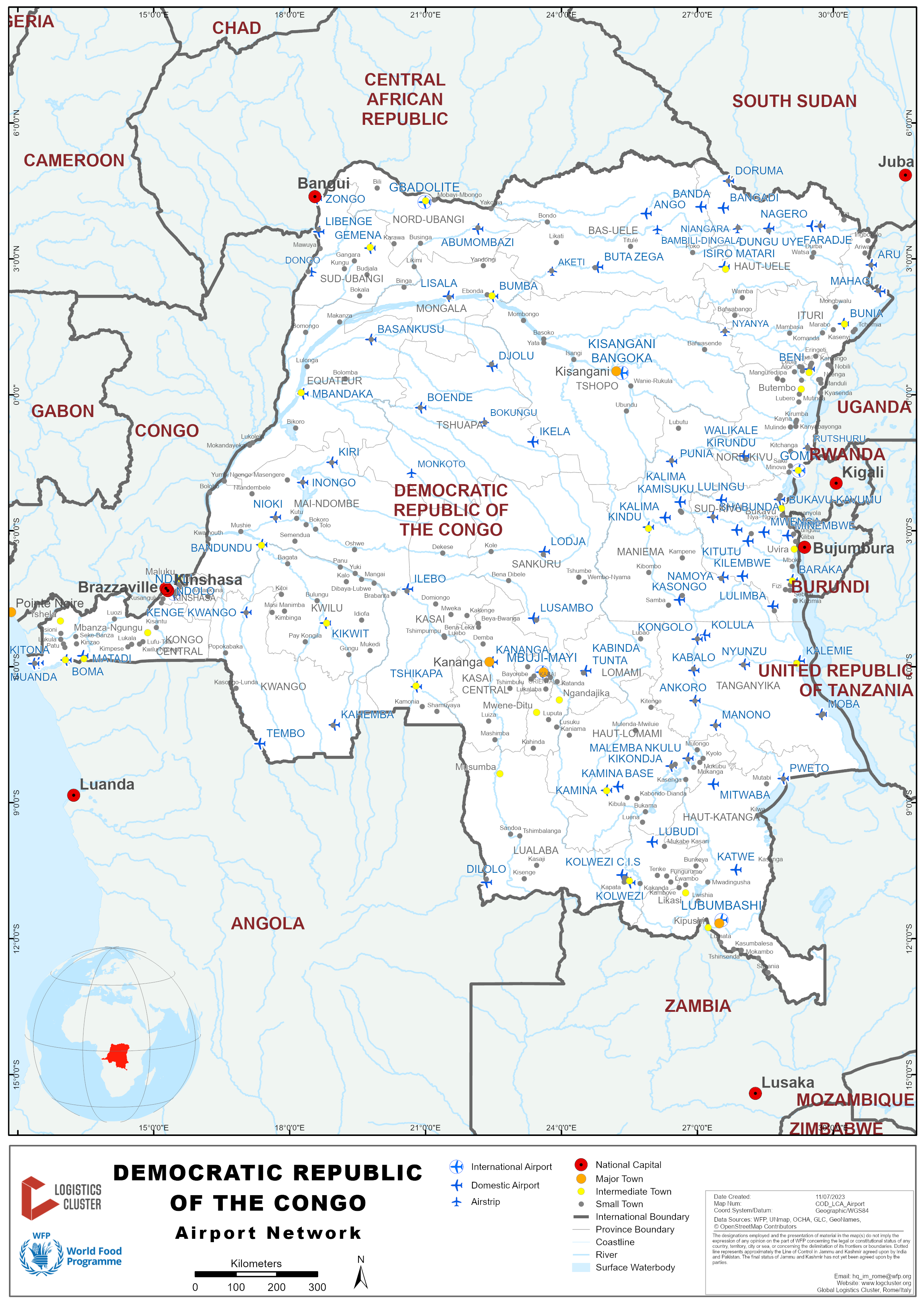
The Autorité de l’Aviation Civile de la République Démocratique du Congo (AAC /RDC) is the national regulatory authority in charge of the regulations, supervision and control of civil aviation activities in accordance with the principles of the International Civil Aviation Organization (ICAO).
Furthermore, the Régie des Voies Aériennes (RVA) is a state-owned technical and commercial corporation established by Ordinance-Law No. 72-013 of 21 February 1972 that manages 53 airports as of August 2022. It is responsible for designing, building, developing, maintaining and operating the airports, managing DRC’s airspace and ensuring air navigation safety. It is also responsible for the commercial exploitation of airport equipment and facilities and training its staff.
-
Four International airports: Kinshasa N’djili, Goma, Lubumbashi Luano and Kisangani
-
Sixteen National airports: Mbuji-Mayi, Bukavu, Kananga, Kinshasa N’dolo, Mbandaka, Bandundu, Bunia, Gemena, Isiro, Kalemie, Kindu, Kolwezi, Lodja, Mwanda, Gbadolite, Tshikapa
-
Thirty-three aerodromes
The air transport sector is not reliable with a dilapidated airport infrastructure system, which requires public and private investment for rehabilitation. Thus, the government is committed to modernizing this sector with the objective of meeting ICAO aviation safety standards through past and ongoing improvements plans such as the following.
Two aviation safety projects funded by the Groupe de la Banque Africaine de Development (BAD) with the past 2010 - 2015 Projet Prioritaire de Sécurité Aérienne Phase 1 (PPSA I) and the ongoing 2018-2022 Projet Prioritaire de Sécurité Aérienne Phase 2 (PPSA II). Those two projects included construction and renovation works of airport control towers, construction of fire stations and safety fences, acquisition of firefighting and rescue vehicles and airport security equipment (Kinshasa N’djili, Kisangani, Lubumbashi Luano, Kindu & Mbuji-Mayi)
The Projet d'Amélioration de la Sécurité à l'Aéroport de Goma (PASAG) managed by the Cellule d’Exécution du Projet du Transport Multimodal (CEPTM) with fundings from the DRC government and the World Bank. Amongst others, it resulted in the building of a new tower control in Goma inaugurated in November 2021, the rehabilitation of the runway (up to a length of 3000 m), and improvement of the airstrip lights.


Goma Airport: a new tower control in November 2021 that complies with international aeronautic standards
For the government, improving the air transport sector will open the country both externally and internally to boost the local economy and to increase the regional trade. Through public and institutional investments, DRC also wants to normalize the air traffic by ensuring the safety of air navigation and aeronautical security and help get the country's airlines off the European Union (EU) blacklist. In this regard, DRC and Ethiopian Air Lines are negotiating a partnership to create a new air company called Air Congo (7 aircrafts, maintenance program and capacity building).The current national airline company Congo Airways is currently operating only an aircraft type A320-200 to cover its domestic network, as three other aircrafts are still under maintenance.
There are numerous private airlines operating in DRC but many of them are banned for transporting staff by UN agencies and most INGOs. The main reason is the still alarming accident record due to disrespect of international aviation standards in-country. Thus, United Nation Humanitarian Air Service (UNHAS) is operating in the whole country with nine aircraft and took over the management of Echo Flight in 2020 (one aircraft and one helicopter).
For more information, contact details and routes, please visit here the DRC Cluster Logistics website.
For more information on government agency and airport company contact information, please see the following links: 4.1 Government Contact List and 4.5 Airport Companies Contact List .
Aviation taxes for passengers
In 2009, the RVA introduced a tax to fund the rehabilitation of airport infrastructures through the Redevance de Développement des Infrastructures Aéroportuaires (IDEF) also called GO PASS.
Current rates are:
-
10 USD per passenger when embarking for a national flight
-
50 USD per passenger when embarking for an international flight
Additional taxes when applicable:
-
Tax from the provincial transport authorities (starting from 5 USD)
-
Statistics tax (in some airports): 5 USD
Procedures for Foreign Registered Aircraft
The request must comply with AAA/RDC ‘s procedures in force as described below to grant an official registration and authorization to operate in DRC. The process is led by the Direction du Transport Aérien (DTA) and may also involve additional national authorities such as DGM (Direction Générale de Migration), SCS (Service du Conseiller Spécial), and Ministère de la Défense Nationale or ARN (Agence Nationale de Renseignement ).
|
Reference |
Description |
|
|---|---|---|
|
POAAC-LEG-09-02 |
Procédure relative à l'octroi de l'autorisation de survol à un aéronef |
|
|
POAAC-LEG-09-03 |
Procédure relative à l'octroi de l'autorisation de survol et atterrissage à un aéronef |
|
|
POAAC-LEG-09-04 |
Procédure octroi de l'autorisation de circulation au-dessus du territoire congolais |
Democratic Republic of Congo - 2.2.1 Democratic Republic of Congo Kinshasa N'Djili SeniorInternational Airport
The Kinshasa/N’Djili Airport is the largest of the six international airports in DRC. It remains the country's most active airport freight terminal. Despite its importance, the existing facility is not in line with international standards and regulations and its location does not provide room to grow nor to facilitate the proper handling of materials.
However, some improvements happened in the last 2 years including a new international passenger terminal and a new control tower. Additional refueling points and taxi extension are also on their way.
|
Location Details |
|||
|---|---|---|---|
|
Country |
The Democratic Republic of Congo |
Latitude |
-4.385736 |
|
Province / District |
Kinshasa |
Longitude |
15.44449 |
|
Town or City (Closest) |
Kinshasa |
Elevation (ft and m) |
1,027 ft / 313.03 m |
|
Airfield Name |
N’DJILI |
IATA and ICAO Codes |
FIH/ FZAA |
|
Open From (hours) |
24 hrs |
Open To (hours) |
24 hrs |

Runways
Existing infrastructure dating back to the independence period have suffered from the cumulative effect of lack of maintenance and successive wars. The Kinshasa N’Djili runway has suffered some damages (cracks, rot, potholes, sinking etc.). A rehabilitation project is currently taking place.
|
Runway #1 |
|
|---|---|
|
Runway Dimensions |
3,300 m x 60 m (previously 4,700 m to be used as US space shuttle emergency landing strip) |
|
Orientation |
243°/063° |
|
Surface |
Asphalt, asphaltic concrete, tar macadam, or bitumen bound macadam. |
Helicopter Pad(s)
There is no landing pad or area or platform for helicopter per se. However, there are some parts of the tarmac area at the Ndjili airport that have been arranged to allow for all types of aircraft to safely land and park.
|
Helipad #1 |
|
|---|---|
|
Present (Yes / No) |
Yes |
|
Largest helicopter that can land |
Mi 26 |
|
Width and Length (metres) |
n/a |
|
Surface |
n/a |
Airport Infrastructure Details
|
Customs |
Yes |
JET A-1 fuel |
Yes |
|---|---|---|---|
|
Immigration |
Yes |
AVGAS 100 |
Yes |
|
Terminal Building |
Yes |
Point Refueling (now 14, soon +7) |
Yes |
|
Passenger Terminal |
Yes |
Air Starter Units |
Yes |
|
Cargo terminal |
Yes |
Ground Power (mobile) |
Yes |
|
Pax transport to airfield |
Yes |
Ground Handling Services |
Yes |
|
Control Tower |
Yes |
Latrine Servicing |
Yes |
|
Weather Facilities |
Yes |
Fire Fighting Category (ICAO) LEVEL 9 |
Yes |
|
Catering Services |
Yes |
De-icing Equipment |
No |
|
Base Operating Room |
Yes |
Parking Ramp Lighting |
Yes |
|
Airport Radar |
No |
Approach & Runway Lights |
Yes |
|
NDB |
Yes |
VOR |
Yes |
|
ILS |
Yes |
ADS-B |
Yes |

Passenger and Cargo Performance Indicator


Hangar for aircraft maintenance Control tower (soon to be replaced)
Total aircraft movements
|
Movements |
|||||||
|---|---|---|---|---|---|---|---|
|
Year |
Domestic |
International |
|||||
|
Arrival |
Departure |
Total |
Arrival |
Departure |
Total |
Grand Total |
|
|
2012 |
5,690 |
5,810 |
11,500 |
3,581 |
3,473 |
7,054 |
18,554 |
| 2013 | 5,849 | 5,864 | 11,713 | 4,010 | 3,979 | 7,989 | 19,702 |
| 2014 | 5,496 | 5,591 | 11,087 | 4,159 | 4,056 | 8,215 | 19,302 |
|
Source: RVA/Service statistiques/Division d'exploitation |
|||||||
Total passengers
|
Passengers |
|||||||
|---|---|---|---|---|---|---|---|
|
Year |
Domestic |
International |
|||||
|
Arrival |
Departure |
Total |
Arrival |
Departure |
Total |
Grand Total |
|
|
2012 |
14,1223 |
171,453 |
312,676 |
206,036 |
208,430 |
414,466 |
727,142 |
| 2013 | 131,606 | 142,666 | 274,272 | 240,796 | 238,860 | 479,656 | 753,928 |
| 2014 | 139,618 | 144,068 | 283,686 | 245,589 | 244,063 | 489,652 | 773,338 |
|
Source: RVA/Service statistiques/Division d'exploitation |
|||||||


BOEING 787 New Passenger Terminal
Total Cargo
|
AIR FREIGHT |
|||||||
|---|---|---|---|---|---|---|---|
|
Year |
Domestic |
International |
|||||
|
Arrival |
Departure |
Total |
Arrival |
Departure |
Total |
Grand Total |
|
|
2012 |
13,896 |
35,160 |
49,056 |
15,271 |
5,220 |
20,348 |
69,404 |
| 2013 | 16,514 | 35,541 | 52,055 | 19,037 | 5,310 | 24,347 | 76,403 |
| 2014 | 14,004 | 33,143 | 47,147 | 21,053 | 4,747 | 25,801 | 72,949 |
|
Source: RVA/Service statistiques/Division d'exploitation |
|||||||
Cargo planes commonly used in DRC


ANTONOV 26 BOEING 727
Airport Operating Details
| Operating Details | |||
|---|---|---|---|
| Maximum sized aircraft which can be offloaded on bulk cargo: |
All type of common cargo-carrying aircraft types including:
NB: AN 225 landing not confirmed but C5 Galaxy did land. |
||
| Maximum sized aircraft that can be offloaded on pallet | see above | ||
| Total aircraft parking area (m²) |
There are 3 Parking areas: The Congolese Air Force parking The "Hangar Technique" parking, which is currently undergoing extension, has a surface of 31,500 square meters. It can accommodate up to 10 aircraft. The Tarmac or Central Parking allocated to both National and International airlines including cargo totals 60,000 square meters. The Central parking has 14 parking among which the Parking #9, 10 and 11 are dedicated to Cargo freighters. (Source: RVA N'Djili, Division circulation Aérienne) |
||
| Storage Area (mt) | Very limited * | Cubic Meters (m³) | n/a |
| Cargo Handling Equipment Available (Yes / No) | Yes | If "Yes" specify below | |
| Elevators / Hi Loaders (Yes / No) | Yes | Max Capacity (mt) | n/a |
| Can elevators / Hi Loaders reach the upper level of a B747 (Yes / No) | Yes | ||
| Loading Ramps (Yes / No) | Yes | ||
Handling companies present on the ground (4):
CONGO HANDLING SERVICE / CHS


Congo Handling Service's cargo handling equipment list
AFRICAN TRANSPORT SYSTEMS / ATS
Information on ATS can be found on its website.
CARGOMAN


Cargoman's cargo handling equipment list
GAS / Global Aviation Service
Information on ATS can be found on its website.
Storage Facilities
There is a public bonded warehouse which is under the management of DGDA (Direction Générale des Douanes et Accises). Only 2 private bonded warehouses are available (Bolloré Africa Logistics – BAL and DHL express): Bolloré’s is 600 sqm and DHL’s is smaller. For large amounts of cargo, BAL usually transfers the goods to their warehouse in town (named Air France Cargo location), with a special customs procedure (enlèvement d’urgence permanent).
NB: BAL has a cold room (2 x 40’ reefers) in the airport which can activated upon request. DGDA has one too (190 cbm), but it’s believed unreliable (tbc). DHL’s is apparently in renovation.


Boloré’s warehouse DHL warehouse
Airfield Cost
See 2.2 Democratic Republic of Congo Aviation
Navigation Charges
See 2.2 Democratic Republic of Congo Aviation
Cargo Terminal Charges
See 2.2 Democratic Republic of Congo Aviation
Security
The main weaknesses of the air transport system in DRC include the advanced state of dilapidation of airport infrastructure, obsolete air navigation equipment and lack of resources to enable the administration to effectively perform its air safety and security supervision functions. In addition, the country is in a strategic position in the air transport industry at the regional and international levels because most flights between Southern Africa and Europe as well as between Southern Africa, West, and East Africa use its vast airspace without adequate visualization or surveillance systems.
Democratic Republic of Congo - 2.2.2 Democratic Republic of Congo (DRC) Goma International Airport
Airport Overview
Goma International Airport plays a key role as the main air hub for East Congo. In the last few years, the airport’s safety has been upgraded with an extension of the runway and the building of a new tower control (PASAG projects). However, the airport remains vulnerable with the active volcano Nyiragongo located about 20 km from Goma (last eruption in May 2021).
|
Airport Location and Contact |
|
|---|---|
|
Country |
Republic Democratic of Congo |
|
Province or District |
North Kivu |
|
Nearest Town or City with Distance from Airport |
Goma |
|
Airport’s Complete Name |
Goma International Airport |
|
Latitude |
-1.670856 |
|
Longitude |
29.238403 |
|
Elevation (ft and m) |
5,045 ft – 1538 m |
|
IATA Code |
GOM |
|
ICAO Code |
FZNA |
|
Managing Company or Airport Authority |
Régie des Voies Aériennes |
|
Management Contact Person |
+ 243 815 136 006 |
|
Open from to (hours) |
24 Hours |
Port Picture

Description and Contacts of Key Companies
Daily commercial and cargo flights connect Goma to Kinshasa, other main cities of DRC (Bunia, Beni, Kalémie, Kissangani) and one African capital (Addis Ababa), from where a connection to Europe Middle East is available. Flight cancellations without prior notice often occur and passengers can wait several days before their flight is rescheduled. In addition, fuel storage has been impacted by recent the current crisis in Europe.
Below airline companies currently operating at Goma Airport:
CAA, Congo Airways, Ethiopan Airlines, Gomair, Malu Aviation, Servair Cargo, Trans Air Cargo Service.
For more information on airport contacts, please see the following link: 4.5 Airport Companies Contact List.
Passenger and Cargo Performance Indicator
|
Total Aircraft Movements |
||||
|---|---|---|---|---|
|
Performance |
Arrival |
Departure |
||
|
GOMA |
Domestic |
International |
Domestic |
International |
|
2021 |
9,053 |
798 |
9,033 |
808 |
|
2020 |
7,100 |
666 |
7,115 |
643 |
|
2019 |
8,731 |
822 |
8,666 |
882 |
Source : Statistique RVA
|
Total Passangers |
||||
|---|---|---|---|---|
|
Performance |
Arrival |
Departure |
||
|
GOMA |
Domestic |
International |
Domestic |
International |
|
2021 |
104,541 |
35,817 |
103,125 |
34,420 |
|
2020 |
68,679 |
21,850 |
66,678 |
22,571 |
|
2019 |
121,494 |
21,988 |
114,851 |
22,406 |
Source : Statistique RVA
|
Total Cargo (in mt) |
||||
|---|---|---|---|---|
|
Performance |
Arrival |
Departure |
||
|
GOMA |
Domestic |
International |
Domestic |
International |
|
2021 |
5 234,762 |
859,214 |
20 012,593 |
270,031 |
|
2020 |
3 988,066 |
671,809 |
16 450,138 |
216,045 |
|
2019 |
5 132,840 |
437,300 |
14 836,890 |
310,303 |
Source : Statistique RVA
Runways
|
Runway #1 |
|
|---|---|
|
Runway Dimensions |
2995 x 45 |
|
Orientation |
17/35 |
|
Surface |
Macadam/Tarmac |
Airport Infrastructure Details
|
Customs |
Yes |
JET A-1 fuel |
Yes |
|
Immigration |
Yes |
AVGAS 100 |
n/a |
|
Terminal Building |
Yes |
Single Point Refueling |
n/a |
|
Passenger Terminal |
Yes |
Air Starter Units |
n/a |
|
Cargo terminal |
Yes |
Ground Power (mobile) |
n/a |
|
Pax Transport to Airfield |
Yes |
Ground Handling Services |
Yes |
|
Control Tower |
Yes |
Latrine Servicing |
n/a |
|
Weather Facilities |
Yes |
Fire Fighting Category (ICAO) |
7 |
|
Catering Services |
Yes |
De-icing Equipment |
n/a |
|
Base Operating Room |
Yes |
Parking Ramp Lighting |
n/a |
|
Airport Radar |
Yes |
Approach & Runway Lights |
Yes |
|
NDB |
Yes |
VOR |
Yes |
|
ILS |
n/a |
|
|
Airport Operating Details
|
Operating Details |
|||
|---|---|---|---|
|
Loading Ramps |
Yes |
||
|
Elevators / Hi Loaders |
Yes |
||
United Nation Humanitarian Air Service (UNHAS)
Since 2008, UNHAS has provided air access throughout the country and has added new remote destinations for helicopter services that support the humanitarian response in Ituri, North and South Kivu, which are unreachable with fixed-wing aircraft. UNHAS DRC offers fifty destinations with a fleet of nine aircraft strategically based in Kinshasa, Goma, Bunia, and Kalemie, to respond effectively to regular demand and emergencies/evacuations.
Contact details, routes and flight schedules are available in DRC Logistics Cluster website here .
Customs Guidance
For information on customs in Democratic Republic of Congo, please see the following link: 1.3 Customs Information.
Airfield Costs
FUEL SERVICES CHARGES
The cost of importing jet fuel has increased recently and the country faced shortage in September 2022. The Ministry of Hydrocarbons has implemented a contingency plan that includes rationing fuel until the arrival of new stocks. Due to this context, prices are fluctuating and the current fuel price list is available on the website of the Ministry of Economy here.
Democratic Republic of Congo - 2.2.3 Democratic Republic of Congo Lubumbashi First ClassInternational Airport (Category 1)
Lubumbashi airport is in fact the second most important Congolese airport in terms of aviation activity, especially with international traffic. This is because of the intense economic activity in the region, mainly in and around mining. This has allowed the creation of several private domestic airlines, mainly for VIP (helicopter or jet) and freight (cargo planes) transport.

|
Airport Details |
|
||
|---|---|---|---|
|
Country |
DRC |
Latitude |
-11.59111 |
|
Province / District |
HAUT KATANGA |
Longitude |
27.525 |
|
Airport Name |
Lubumbashi airport |
Elevation (ft and m) |
4,295 ft / 1309.12 m |
|
IATA & ICAO codes |
FBM / FZQA |
Surface |
Asphalt |
|
Town or City (closest) |
Lubumbashi |
Runway Condition |
GOOD |
|
Humanitarian air agencies using regularly this facility |
UNHAS ECHOFLIGHT MAF |
Passenger / Cargo Security Screening (Yes / No) |
YES |
|
Runway Dimension |
3,150 m x 50 m |
Ground Handling (Yes / No) |
YES |
|
Refueling Capacity |
YES |
Runway Lighting (Yes / No) |
YES |
|
Runway Heading |
YES |
Fire Fighting Equipment (Yes / No) |
YES |
|
Air Traffic Control (Yes / No) |
YES |
Windsock (Yes / No) |
YES |
|
Weather Information (Yes / No) |
YES |
Aircraft Parking space (Yes / No) |
YES |
|
Navigation Aids (Yes / No) |
YES |
Perimeter fencing (Yes / No) |
YES |


Passenger’s terminal (tarmac side) Passenger’s terminal (public access)
International Airlines with regular flights to Lubumbashi:
- Ethiopian Airlines
- Kenya Airways
- South African Airways
NB: Please note that Korongo Airlines (Brussels Airlines joint partner) shut down their activity in September 2015. This was the only Congolese airline authorized to UN staff and most NGOs between Lubumbashi and Kinshasa.


Main taxi area for passenger planes Medium size cargo plane for rent (ITAB)
Democratic Republic of Congo - 2.2.4 Democratic Republic of Congo Gbadolite First ClassNational Airport (Category 2)
Gbadolite airport used to be the best equipped airport at the time of its splendor. Since 1997, it has unfortunately been looted several times and stripped of of all its aviation equipment. It remains, however, one of the longest airstrips in the DRC, and is located in a humanitarian hotspot due to the Central African refugee crisis.

|
Airport Details |
|
||
|---|---|---|---|
|
Country |
DRC |
Latitude |
4.25 |
|
Province / District |
NORTH UBANGI |
Longitude |
20.96667 |
|
Airport Name |
Gbadolite airport |
Elevation (ft) |
1,509 ft / 459.94 m |
|
IATA & ICAO codes |
BDT / FZFD |
Surface |
Asphalt |
|
Town or City (closest) |
Gbadolite |
Runway Condition |
GOOD |
|
Humanitarian air agencies using regularly this facility |
UNHAS ECHOFLIGHT |
Passenger / Cargo Security Screening (Yes / No) |
NO |
|
Runway Dimension |
3,200 m x 60 m |
Ground Handling (Yes / No) |
NO |
|
Refueling Capacity |
NO |
Runway Lighting (Yes / No) |
NO |
|
Runway Heading |
NO |
Fire Fighting Equipment (Yes / No) |
NO |
|
Air Traffic Control (Yes / No) |
NO |
Windsock (Yes / No) |
YES |
|
Weather Information (Yes / No) |
NO |
Aircraft Parking space (Yes / No) |
YES |
|
Navigation Aids (Yes / No) |
NO |
Perimeter fencing (Yes / No) |
NO |


Abandoned & non serviceable ground equipment and Main taxi for (manual) offloading.
Democratic Republic of Congo - 2.2.5 Democratic Republic of Congo Kisangani / Bangoka FirstClass National Airport (Category 2)
Built in 1978, to replace the other airport in town (now only for military use), Bangoka airport is located in the medium north of DRC. The nearby town of Kisangani is connected by roads and rivers to the West and the East of the country. This airport used to be a key hub in the economy and in humanitarian responses since the 1990s. The main building is a large passenger terminal (currently in renovation) able to host a large number of passengers. The cargo possibilities is unfortunately very restrained due to lack of ground equipment and warehousing. Custom and immigration services are nevertheless present and operational.
The airport seems to be now in decline with only bi-weekly flights from MONUSCO, from private airline CAA and occasionally the private cargo airline SERVICE AIR. However, Bangoka has been included in an ABD (African Bank Development) project for the renovation of DRC’s airports and some parts of the airport are now being rehabilitated (Congo aviation authority office, control tower, generator’s room). MONUSCO has donated firefighting equipment. It is unclear when the renovation work will be completed.

|
Airport Details |
|
||
|---|---|---|---|
|
Country |
DRC |
Latitude |
0.483333 |
|
Province / District |
TSHOPO |
Longitude |
25.33333 |
|
Airport Name |
Bangoka airport |
Elevation (ft) |
1,417 ft / 431.90 m |
|
IATA & ICAO codes |
FKI / FZIC |
Surface |
Asphalt |
|
Town or City (closest) |
Kisangani |
Runway Condition |
GOOD |
|
Humanitarian air agencies using regularly this facility |
N/A |
Passenger / Cargo Security Screening (Yes / No) |
NO |
|
Runway Dimension |
3,500 m x 45 m |
Ground Handling (Yes / No) |
Limited |
|
Refueling Capacity |
YES |
Runway Lighting (Yes / No) |
YES* |
|
Runway Heading |
NO |
Fire Fighting Equipment (Yes / No) |
YES |
|
Air Traffic Control (Yes / No) |
YES |
Windsock (Yes / No) |
YES |
|
Weather Information (Yes / No) |
YES |
Aircraft Parking space (Yes / No) |
YES |
|
Navigation Aids (Yes / No) |
NO |
Perimeter fencing (Yes / No) |
NO |
* On request in advance (powered by generator)


The existing control tower. One of the firefighting vehicles currently on duty.


The main parking area. The passenger terminal building.
NB:
- The biggest aircraft that has landed here is an ANTONOV 124.
- There are fees for vehicle access on tarmac: $20 USD/day, $300 USD/year.
Democratic Republic of Congo - 2.2.6 Democratic Republic of Congo (DRC) Kavumu National Airport ( Bukavu)
Airport Overview
|
Airport Location and Contact |
|
|---|---|
|
Country |
Democratic Republic of the Congo |
|
Province or District |
Sud Kivu |
|
Nearest Town or City |
Bukavu Distance: 35 km (1 hour drive by car) |
|
Airport’s Complete Name |
Kavumu |
|
Latitude |
-2.309215 |
|
Longitude |
28.808185 |
|
Elevation (ft and m) |
5,655 ft – 1725 m |
|
IATA Code |
BKY |
|
ICAO Code |
FZMA |
|
Managing Company or Airport Authority |
Régie des Voies Aériennes |
|
Management Contact Person |
Commandant de l’Aéroport : Patrick MUKULUMANYA + 243 814 284 292
Chef de circulation aérienne : Douglas NGANGA + 243 999 329 760 |
|
NGO and/or UN Presence at Airport? |
UNHAS (Contact details, routes and flight schedules are available on the DRC Logistics Cluster website here) |
A dozen airline companies for cargo activities (e.g. Swala Aviation, Busy Bee Congo, Servair Cargo, Gomair) are operating at Kavumu Airport. MONUSCO has improved the airport facilities during the last years.
Airport Picture

Runway(s)
|
Runway #1 |
|
|---|---|
|
Runway Dimensions |
2000 x 45 m |
|
Runway Orientation |
17/35 |
|
Runway Surface |
Macadam |

Airport Infrastructure Details
|
Infrastructure |
|||
|---|---|---|---|
|
Passenger / Cargo Security Screening |
Yes |
Runway Lighting |
No |
|
Refueling Capacity |
Yes |
Ground Handling Services |
Yes |
|
Air Traffic Control |
Yes |
Fire Fighting Equipment |
Yes |
|
Weather Information |
Yes |
Aircraft Parking Space |
Yes |
|
Navigation Aids |
Yes |
Perimeter Fencing |
Yes |
|
Windsock |
Yes |
|
|
Fuel Services Charges
The cost of importing jet fuel has recently increased and the country faced shortages last September 2022. The Ministry of Hydrocarbons has implemented a contingency plan that includes rationing fuel until the arrival of new stocks. Due to this context, prices are fluctuating and the current fuel price list is available on the website of the Ministry of Economy here.
Democratic Republic of Congo - 2.2.7 Democratic Republic of Congo Kinshasa N'Dolo SecondClass National Airport (Category 1)
The Kinshasa Ndolo airport hosts the General Staff of the DRC Air Force and their air base. It features some standard airworthy equipment.
|
Airport Details |
|||
|---|---|---|---|
|
Country |
DRC |
Latitude |
-4.326689 |
|
Province / District |
Kinshasa |
Longitude |
15.32734 |
|
Airport Name |
N’dolo |
Elevation (ft) |
914.99 ft / 278.89 m |
|
IATA & ICAO codes |
NLO / FZAB |
Surface |
Asphalt |
|
Town or City (closest) |
Kinshasa |
Runway Condition |
Runway, off-ramp and tarmac in bad condition |
|
Humanitarian air agencies using regularly this facility |
ECHOFLIGHT ICRC / MSF |
Passenger / Cargo Security Screening (Yes / No) |
Yes |
|
Runway Dimension |
1,300 m x 30 m |
Ground Handling (Yes / No) |
Yes |
|
Refueling Capacity |
Yes |
Runway Lighting (Yes / No) |
Yes |
|
Runway Heading |
Yes |
Fire Fighting Equipment (Yes / No) |
Yes |
|
Air Traffic Control (Yes / No) |
Yes |
Windsock (Yes / No) |
Yes |
|
Weather Information (Yes / No) |
Yes |
Aircraft Parking space (Yes / No) |
Yes |
|
Navigation Aids (Yes / No) |
Yes |
Perimeter fencing (Yes / No) |
Yes |
Democratic Republic of Congo - 2.2.8 Democratic Republic of Congo Bunia National Airport(Category 2)
Most of the National airports and airfields do not possess the adequate infrastructure nor offer the services demanded by the airline industry.
|
Airport Details |
|||
|---|---|---|---|
|
Country |
DRC |
Latitude |
1.565719 |
|
Province / District |
PROVINCE ORIENTALE |
Longitude |
30.22083 |
|
Airport Name |
BUNIA Airport |
Elevation (ft) |
4,045 ft / 1,232.92 m |
|
IATA & ICAO codes |
BUX / FZKA |
Surface |
Asphalt |
|
Town or City (closest) |
BUNIA |
Runway Condition |
Good |
|
Humanitarian air agencies using regularly this facility |
UNHAS ECHOFLIGHT MAF |
Passenger / Cargo Security Screening (Yes / No) |
No |
|
Runway Dimension |
1,850 m x 30 m |
Ground Handling (Yes / No) |
Yes |
|
Refueling Capacity |
Yes |
Runway Lighting (Yes / No) |
No |
|
Runway Heading |
Yes |
Fire Fighting Equipment (Yes / No) |
Yes |
|
Air Traffic Control (Yes / No) |
Yes |
Windsock (Yes / No) |
Yes |
|
Weather Information (Yes / No) |
Yes |
Aircraft Parking space (Yes / No) |
Yes |
|
Navigation Aids (Yes / No) |
Yes |
Perimeter fencing (Yes / No) |
Yes |


Overview and control tower.
Democratic Republic of Congo - 2.2.9 Democratic Republic Congo Kalemie Second ClassNational Airport (Category 2)
Airport Overview
Kalemie airport is fully operational, operating solely during the day time. The airport has functional taxiways and parking areas.
|
Airport Details |
|||
|---|---|---|---|
|
Country |
DRC |
Latitude |
-5.875525 |
|
Province / District |
KATANGA |
Longitude |
29.24937 |
|
Airport Name |
KALEMIE Airport |
Elevation (ft) |
2,569 ft / 783.03 m |
|
IATA & ICAO codes |
FMI/ FZRF |
Surface |
Asphalt |
|
Town or City (closest) |
n/a |
Runway Condition |
Good |
|
Humanitarian air agencies using regularly this facility |
UNHAS ECHOFLIGHT |
Passenger / Cargo Security Screening (Yes / No) |
No |
|
Runway Dimension |
1,750 m x 30 m |
Ground Handling (Yes / No) |
No |
|
Refueling Capacity |
No |
Runway Lighting (Yes / No) |
No |
|
Runway Heading |
No |
Fire Fighting Equipment (Yes / No) |
No |
|
Air Traffic Control (Yes / No) |
No |
Windsock (Yes / No) |
No |
|
Weather Information (Yes / No) |
No |
Aircraft Parking space (Yes / No) |
No |
|
Navigation Aids (Yes / No) |
No |
Perimeter fencing (Yes / No) |
No |

Services
The airport houses immigration and refuelling facilities. There are no cargo handling facilities.
Access to the airport is good.
The parking areas are in good condition, have a surface area of 7200 m², and can hold 2 hawkers, and 9 small airplanes.
Existing communications means include a radio room and access via mobile phone.
Helicopter Pad(s)
Kalemie airport has a helicopter pad.
Security
The airport, though not fenced, is patrolled by guards and has appropriate alert procedures and communications in place. It is well-lit, and has fire services on hand.
Contact(s)
Airport Focal Point:
AMULI KADALI OLIVIER +243 812357859
Immigration:
NYEMBO ABUNAMBOKA +243 814076021
Security:
AMULI KADALI OLIVIER +243 812357859
Democratic Republic of Congo - 2.2.10 Democratic Republic of Congo Kindu Second ClassNational Airport (Category 2)
Kindu is among the national airports and airfields that do not possess the adequate infrastructures nor offer the services demanded by the airline industry.
|
Airport Details |
|||
|---|---|---|---|
|
Country |
DRC |
Latitude |
-2.919178 |
|
Province / District |
MANIEMA |
Longitude |
25.91536 |
|
Airport Name |
Kindu Airport |
Elevation (ft) |
1,630 ft . 496.82 m |
|
IATA & ICAO codes |
KND/ FZOA |
Surface |
Asphalt |
|
Town or City (closest) |
Kindu |
Runway Condition |
Fair |
|
Humanitarian air agencies using regularly this facility |
UNHAS |
Passenger / Cargo Security Screening (Yes / No) |
No |
|
Runway Dimension |
2,200 m x 45 m |
Ground Handling (Yes / No) |
No |
|
Refueling Capacity |
No |
Runway Lighting (Yes / No) |
No |
|
Runway Heading |
No |
Fire Fighting Equipment (Yes / No) |
No |
|
Air Traffic Control (Yes / No) |
No |
Windsock (Yes / No) |
Yes |
|
Weather Information (Yes / No) |
No |
Aircraft Parking space (Yes / No) |
Yes |
|
Navigation Aids (Yes / No) |
Yes |
Perimeter fencing (Yes / No) |
Yes |


No ground equipment for handling (here a medical organization offloading by hand a B727). Fire truck inherited from MONUSCO.
Democratic Republic of Congo - 2.2.11 Democratic Republic of Congo Butembo Second ClassNational Airport (Category 2)
Airport Overview
Butembo is a large city with an estimated population of 1 million people. The Butembo airstrip runs quite literally through the middle of the city, which unfortunately has reasonably high rates of urban crime. Due to a lack of security at the airport, there are often numbers of people who cross the runway, even when soldiers are deployed to prevent people from doing so. As a result, the runways of the airport are considered dangerous.
| Airport Location and Contact | |
|---|---|
| Country |
Democratic Republic of |
|
Province or District |
North Kivu |
|
Nearest Town or City with Distance from Airport |
The airport literally runs |
|
Airport’s Complete Name |
Butembo airport |
|
Latitude |
0°7’2.07”N |
|
Longitude |
29°18’46.17”E |
|
Elevation (ft and m) |
1500 m |
|
IATA Code |
NO |
|
ICAO Code |
NO |
|
Managing Company or Airport Authority |
RVA |
|
Management Contact Person |
Moise Mbusa |
|
NGO and/or UN Presence at Airport? |
Yes/MONUSCO |
Runway(s)
|
Runway #1 |
|
|---|---|
|
Runway Dimensions |
700 L (m) X 10 W (m) |
|
Runway Orientation |
110°290° |
|
Runway Surface |
Gravel |
|
Runway Condition |
Laterite/bad condition |
Airport Infrastructure Details
|
Infrastructure |
|||
|---|---|---|---|
| Passenger / Cargo Security Screening |
No |
Runway Lighting |
No |
|
Refueling Capacity |
No |
Ground Handling Services |
No |
|
Air Traffic Control |
Yes 118.100 |
Fire Fighting Equipment |
No |
|
Weather Information |
Yes |
Aircraft Parking Space |
Yes |
|
Navigation Aids |
Perimeter Fencing |
No |
|
| Windsock | Yes |
|
|
Fuel Services Charges
There is no fuel service recharge in Butembo.
|
Price per Litre USD - $ |
|
|---|---|
|
Jet A-1 |
N/A |
| Avgas | N/A |
Royalties / Non-Objection Fees (NOFs)
Passengers will have to pay 34 USD for GO pass.
Democratic Republic of Congo - 2.2.12 Democratic Republic of Congo (DRC) Kananga National Airport
Airport Overview
|
Airport Location and Contact |
|
|---|---|
|
Country |
Democratic Republic of Congo |
|
Province or District |
Kasai Central |
|
Nearest Town or City |
Kananga Distance: 7 km (15 minutes drive by car) |
|
Airport’s Complete Name |
Kananga Airport |
|
Latitude |
-5.900083 |
|
Longitude |
22.4692 |
|
Elevation (ft and m) |
2,143 ft – 650,70 m |
|
IATA Code |
KGA |
|
ICAO Code |
FZUA |
|
Managing Company or Airport Authority |
Régie des Voies Aériennes |
|
Management Contact Person |
Commandant de l’Aéroport Patrick BONDO + 243 81 26 425
Coordinateur des Services Gaston MUTOMBA + 243 895 174 628 / +243 991 088 880 |
|
NGO and/or UN Presence at Airport? |
UNHAS (Contact details, routes and flight schedules are available on the DRC Logistics Cluster website here) |
Kananga National Airport currently has an average of sixteen movements per week for both passenger and cargo transportation.
Below are the airline companies operating in Kananga airport: Congo Airways, CAA, Servair Cargo, Goma Air, Air Kasai, Trans Air Cargo Service.
Airport Picture

Runway(s)
|
Runway #1 |
|
|---|---|
|
Runway Dimensions |
2200 x 45 m |
|
Runway Orientation |
11/29 |
|
Runway Surface |
Macadam |
Airport Infrastructure Details
|
Infrastructure |
|||
|---|---|---|---|
|
Passenger / Cargo Security Screening |
Yes |
Runway Lighting |
Yes |
|
Refueling Capacity |
Yes |
Ground Handling Services |
Yes |
|
Air Traffic Control |
Yes |
Fire Fighting Equipment |
Yes |
|
Weather Information |
Yes |
Aircraft Parking Space |
Yes |
|
Navigation Aids |
Yes |
Perimeter Fencing |
Yes |
|
Windsock |
Yes |
|
|
Storage Facilities 
The RVA offers storage solutions such as warehouses and hangars (former MONUSCO compound) and there is also available land to erect a mobile storage unit. Rates are based on the square meter occupied (m²/USD). Written requests are to be addressed to RVA Management for contracting and terms details.
|
Storage Type |
Owner |
Area |
|---|---|---|
|
General Cargo |
RVA |
642 m² |
|
500 m² |
||
|
1,132 m² |
Handling equipment
|
Equipment |
Comments |
|---|---|
|
Forklift |
1 x unit, lifting 15 tons Rental cost is 350 USD per day
|
|
Elevator |
1 x unit, lifting 40 tons Rental cost is 480 USD per day |
Fuel Services Charges
The cost of importing jet fuel has recenly increased and the country faced shortages last September 2022. The Ministry of Hydrocarbons has implemented a contingency plan that includes rationing fuel until the arrival of new stocks. Due to this context, prices are fluctuating and the current fuel price list is available on the website of the Ministry of Economy here.
Jet fuel shortage at SEP airport may occur due to delay to receive replenishment from Ilebo SNCC Port connected with the train (derailment, breakdown locomotive, landslide…).
Democratic Republic of Congo - 2.2.13 Democratic Republic of Congo (DRC) Mbuji Mayi National Airport
Airport Overview
Mbuji Mayi Airport is the fifth airport of DRC in terms of passengers and cargo traffic, and is the main transportation means to supply the city and the province. The African Development Bank Group under the Projet Prioritaire de Sécurité Aérienne - Phase 2 (PPSA II) is funding the airstrip extension up to 3000 x 60 m, a new tower control and a fire station. This project will be completed by the end of December 2024 and will allow the airport to welcome an additional range of aircraft.
|
Airport Location and Contact |
|
|---|---|
|
Country |
Democratic Republic of Congo |
|
Province or District |
Kasai Oriental |
|
Nearest Town or City |
Bipemba Distance: n/a |
|
Airport’s Complete Name |
Mbuji Mayi Airport |
|
Latitude |
-6.121111 |
|
Longitude |
23.568889 |
|
Elevation (ft and m) |
2200 ft – 677 m |
|
IATA Code |
MJM |
|
ICAO Code |
FZWA |
|
Managing Company or Airport Authority |
Régie des Voies Aériennes |
|
Management Contact Person |
Commandant de l’Aéroport Romain TSHINYAMA KABONGO MUKISHI +243 970 069 458 / +243 821 253 071 |
|
NGO and/or UN Presence at Airport? |
UNHAS (Contact details, routes and flight schedules are available on the DRC Logistics Cluster website here) |
Airport Picture

Runway(s)
|
Runway #1 |
|
|---|---|
|
Runway Dimensions |
2000 x 45 m |
|
Runway Orientation |
11/29 |
|
Runway Surface |
Macadam |
Airport Infrastructure Details
|
Infrastructure |
|||
|---|---|---|---|
|
Passenger / Cargo Security Screening |
Yes |
Runway Lighting |
Yes |
|
Refueling Capacity |
Yes |
Ground Handling Services |
Yes |
|
Air Traffic Control |
Yes |
Fire Fighting Equipment |
Yes |
|
Weather Information |
Yes |
Aircraft Parking Space |
Yes |
|
Navigation Aids |
Yes |
Perimeter Fencing |
Yes |
|
Windsock |
Yes |
|
|
Airlines companies
The following airline companies are operating in the airport: Congo Airways, CAA, Servair Cargo , Trans Air Cargo Service.
Storage Facilities
The RVA has a warehouse, which is a prefabricated structure left by MONUSCO, There is available land to erect mobile storage units. Written requests for contracting and terms are to be addressed to RVA Management.
Handling equipment
Handling equipment is not available at the airport at the moment, however, RVA Management is currently sourcing a supplier to deliver this service.
Fuel Services Charges
The cost of importing jet fuel has recently increased and the country faced shortages last September 2022. The Ministry of Hydrocarbons has implemented a contingency plan that includes rationing fuel until the arrival of new stocks. Due to this context, prices are fluctuating and the current fuel price list is available on the website of the Ministry of Economy here.
Jet fuel shortage at SEP airport may occur due to delay to receive replenishment from Ilebo SNCC Port connected with the train (derailment, breakdown locomotive, landslide…).
Democratic Republic of Congo - 2.3 Democratic Republic of Congo Road Network

The country’s road network is in an extremely bad state of repair following years of armed conflicts. In theory, the road network comprises 58,358 km of national roads, 86,615 km of rural roads, and 7,400 km of urban roads.
According to estimates, only 5 per cent of the 58,000 km of the national roads are sealed. These sections are mainly located on the axis between Matadi and Kinshasa, Lubumbashi and the Zambian border and some sections in the eastern part of the country. (Source: Ministère des Transports et Voies de Communication Cellule d’Exécution du Projet de Transport Multimodal Report Annuel 2011)
Although there is little reliable detailed information, a large proportion of the road network is known to be in need of repairs. The two main highways on the national road network are the East-West road (linking the port of Matadi to Lubumbashi via Kinshasa) and the North-South road (linking Lubumbashi to Goma, Bukavu and Kisangani).
Recent road quality indicators suggest that the state of the country’s limited paved network (fewer than 3,000 km) has improved considerably and is now comparable with those of other low income countries in the region. (Source: African Development Bank Group)
4.1 Democratic Republic of Congo Government Contact List
Distance Matrix
|
Distances from Capital City to Major Towns (km) |
|||||||||||
|---|---|---|---|---|---|---|---|---|---|---|---|
|
KINSHASA |
MATADI |
BANDUNDU |
KANANGA |
MBUJI MAYI |
LUBUMBASHI |
KINDU |
BUKAVU |
GOMA |
KISANGANI |
MBANDAKA |
|
|
KINSHASA |
355 |
490 |
1,105 |
1,283 |
2,317 |
2,033 |
2,660 |
2,709 |
2,624 |
3,192 |
|
|
MATADI |
355 |
1,051 |
1,460 |
1,638 |
2,672 |
2,388 |
3,015 |
3,064 |
2,979 |
3,547 |
|
|
BANDUNDU |
490 |
1,051 |
973 |
1,151 |
2,184 |
1,901 |
2,528 |
2,577 |
2,492 |
3,059 |
|
|
KANANGA |
1,105 |
1,460 |
973 |
179 |
1,212 |
928 |
1,556 |
1,604 |
1,520 |
2,087 |
|
|
MBUJI MAYI |
1,283 |
1,638 |
1,151 |
179 |
1,036 |
752 |
1,379 |
1,428 |
1,344 |
1,911 |
|
|
LUBUMBASHI |
2,317 |
2,672 |
2,184 |
1,212 |
1,036 |
1,421 |
1,432 |
1,655 |
2,013 |
2,831 |
|
|
KINDU |
2,033 |
2,388 |
1,901 |
928 |
752 |
1,421 |
627 |
841 |
591 |
1,878 |
|
|
BUKAVU |
2,660 |
3,015 |
2,528 |
1,556 |
1,379 |
1,432 |
627 |
|
220 |
647 |
2,028 |
|
GOMA |
2,709 |
3,064 |
2,577 |
1,604 |
1,428 |
1,655 |
841 |
220 |
|
856 |
2,237 |
|
KISANGANI |
2,624 |
2,979 |
2,492 |
1,520 |
1,344 |
2,013 |
591 |
647 |
856 |
|
1,577 |
|
MBANDAKA |
3,192 |
3,547 |
3,059 |
2,087 |
1,911 |
2,831 |
1,878 |
2,028 |
2,237 |
1,577 |
|
Road Security
DRC's territory is partially enclosed. Almost all the provincial capitals can only be reached by air. The national road network is approximately 152,400 km long--only 2% of which is sealed--is in a state of disrepair. Of the priority roads (covering 30,786 km), 25% of which are in good condition, 16% in fair condition and 59% in poor condition.
Out of the 86,821 km of local roads, only 11% are in good condition. (Source: RDC - 2011-2015 - Document de stratégie de réduction de la pauvreté P. 64). There are also roads with checkpoints manned by DRC security forces, which sometimes set up temporary roadblocks, especially at night.
Vehicles are often searched for weapons and valuables and travelers are checked for identity papers. All forms of public transportation are unregulated. Taxis, mini-buses and trains are in poor mechanical condition and are often filled beyond capacity.
Weighbridges and Axle Load Limits
Axle load limit in DRC is derived from the Arrêté Interministériel Instituant des Mesures de Protection du Patrimoine Routier National de 2011.
|
Axle load limits |
LCA Country |
Transit Country |
Transit Country |
|---|---|---|---|
|
Truck with 2 axles |
21 tons |
16,000 kg |
18,000 kg |
|
Truck with 3 axles |
27 tons |
22,000 kg |
24,000 kg |
|
Truck with 4 axles |
50 tons |
26,000 kg |
28,000 kg |
|
Semi-trailer with 3 axles |
50 tons |
26,000 kg |
28,000 kg |
|
Semi-trailer with 4 axles |
50 tons |
34,000 kg |
36,000 kg |
|
Semi-trailer with 5 axles |
50 tons |
40,000 kg |
44,000 kg |
|
Semi-trailer with 6 axles |
50 tons |
46,000 kg |
50,000 kg |
|
Truck & drawbar trailer with 4 axles |
50 tons |
34,000 kg |
37,000 kg |
|
Truck & drawbar trailer with 5 axles |
50 tons |
40,000 kg |
45,000 kg |
|
Truck & drawbar trailer with 6 axles |
50 tons |
46,000 kg |
53,000 kg |
|
Truck & drawbar trailer with 7 axles |
50 tons |
n/a |
56,000 kg |
Road Class and Surface Conditions
There are several classifications of roads in DRC.
As per the official classification, roads are divided into four distinct categories which are managed by various Governmental bodies.
- National Roads
- Priority regional roads
- Secondary regional roads
- Local roads
The National roads, including Priority and Secondary roads, are managed by Office des Routes (OdR).
Local roads are managed by the Direction des voies de Desserte Agricole (DVDA).
The Office des Voiries et Drainage is in charge of all urban roads comprise of sealed and paved roads.
|
Classification |
Road Description |
|---|---|
|
National road (Bitumen-Gravel) |
All paved and dirt roads intended to be paved on major international routes and on major national routes. These roads are part of the public domain of the State and are managed by Office des Routes |
|
Priority Regional road (Sand / Dirt – Gravel) |
They are public domain of the Province and are also managed by Office des Routes |
|
Secondary Regional Road (Sand / Dirt – Gravel) |
They are public domain of the Province and are also managed by Office des Routes |
|
Local road (Sand / Dirt – Gravel) |
They are public domain of the Province and are managed by the Direction des Voies de Desserte Agricole |
Road Inventory
The road network is organized as a network of national roads and each province maintains a network of provincial roads. The provincial roads are divided into a network of priority and secondary roads.
|
National road (RN) (Bas Congo) |
Office des Routes |
1,370 km |
|---|---|---|
|
Priority provincial road (RP1) (Bas Congo) |
Office des Routes |
891 km |
|
Secondary provincial road (RP2) (Bas Congo) |
Office des Routes |
869 km |
|
National road (RN) (Bandundu) |
Office des Routes |
2,177 km |
|
Priority provincial road (RP1) (Bandundu) |
Office des Routes |
3,505 km |
|
Secondary provincial road (RP2) (Bandundu) |
Office des Routes |
3,160 km |
|
National road (RN) (Equateur) |
Office des Routes |
2,939 km |
|
Priority provincial road (RP1) (Equateur) |
Office des Routes |
2,707 km |
|
Secondary provincial road (RP2) (Equateur) |
Office des Routes |
3,158 km |
|
National road (RN) (Prov. Orientale) |
Office des Routes |
3,612 km |
|
Priority provincial road (RP1) (Prov. Orientale) |
Office des Routes |
3,578 km |
|
Secondary provincial road (RP2) (Prov. Orientale) |
Office des Routes |
3,075 km |
|
National road (RN) (South Kivu) |
Office des Routes |
1,023 km |
|
Priority provincial road (RP1) (South Kivu) |
Office des Routes |
873 km |
|
Secondary provincial road (RP2) (South Kivu) |
Office des Routes |
0 km |
|
National road (RN) (Katanga) |
Office des Routes |
4,064 km |
|
Priority provincial road (RP1) (Katanga) |
Office des Routes |
4,024 km |
|
Secondary provincial road (RP2) (Katanga) |
Office des Routes |
2,958 km |
|
National road (RN) (Kasaï Occidental) |
Office des Routes |
1,909 km |
|
Priority provincial road (RP1) (Kasaï Occidental) |
Office des Routes |
1,230 km |
|
Secondary provincial road (RP2) (Kasaï Occidental) |
Office des Routes |
859 km |
|
National road (RN) (Kasaï Oriental) |
Office des Routes |
1,457 km |
|
Priority provincial road (RP1) (Kasaï Oriental) |
Office des Routes |
1,627 km |
|
Secondary provincial road (RP2) (Kasaï oriental) |
Office des Routes |
1,234 km |
|
National road (RN) (Kinshasa) |
Office des Routes |
252 km |
|
Priority provincial road (RP1) (Kinshasa) |
Office des Routes |
0 km |
|
Secondary provincial road (RP2) (Kinshasa) |
Office des Routes |
0 km |
|
National road (RN) (North Kivu) |
Office des Routes |
823 km |
|
Priority provincial road (RP1) (North Kivu) |
Office des Routes |
534 km |
|
Secondary provincial road (RP2) (North Kivu) |
Office des Routes |
389 km |
|
National road (RN) (Maniema) |
Office des Routes |
1,057 km |
|
Priority provincial road (RP1) (Maniema) |
Office des Routes |
1,212 km |
|
Secondary provincial road (RP2) (Maniéma) |
Office des Routes |
1,543 km |
Bridges
The road network under the responsibility of the Office des Routes is comprised of 1,886 bridges including 445 permanent bridges (concrete structures) which represents 23% of bridges, 750 semi-permanent bridges (metallic structures) and 691 temporary bridges representing 37% of bridges.
Given their ages, more than 90% of the bridges are in a poor or average condition. An analysis of the modernization of 118 bridges was conducted.
The table below shows the distribution of the bridges by province and by type:

Distribution of bridges by provinces and types (Source: Office des Routes: Rapport Annuel D’activités – Exercise 2011)
Kongo Central Province (ex Bas Congo)
Below is the map of the main road network in Kongo Central Province.

Maï-Ndombe, Kwilu and Kwango Provinces (ex Bandundu)
Below is the map of the main road networks in Maï-Ndombe, Kwilu and Kwango Provinces.

North Ubangui, South Ubangui and Mongala Provinces (parts of ex Equateur)
Below is the map of the main road networks in North Ubangui, South Ubangui and Mongala Provinces.

Distances by road:

More distances can be found in this Road Matrix.
Distances by boat:

Kasaï Oriental, Lomami and Sankuru Provinces (ex Kasaï Occidental)
Below is the map of the main road networks in Kasaï Oriental, Lomami and Sankuru Provinces.

Kasaï and Kasaï Central Provinces (ex Kasaï Oriental)
Below is the map of the main road networks in Kasaï and Kasaï Central Provinces.

Tanganyka Province (part of ex Katanga)
The capital of this province, Kalémie, is now better connected to the North (Bukavu) and the South (Pweto then Lubumbashi) through some well-built roads (especially between Pweto and Lubumbashi). However, the rest of the road network is difficult and can be seriously affected by the weather conditions.
Below is the map of the main road network in Tanganyka Province.

Distances can be found in this Road Matrix of all ex Katanga Province.
Haut Katanga Province (part of ex Katanga)
Distances for all destinations in ex Katanga Province from Lubumbashi can be found in this Road Matrix.
KEY INFO
Lubumbashi – Pweto: 2 days by road (487 km)
Lubumbashi – Kalémie: 5 days by road (1,141 km)
Maniema Province
This province is seriously landlocked as rail solutions are unreliable and roads (especially North and North East) are in a very bad condition.
Below is a Distance Matrix for Maniema Province.

KEY INFO
For now, the only road access to South Kivu Province is a medium size road starting from Kindu, going south to Kasongo, then north-east to the border with South Kivu province, and, in Matala village, finally south-east along the border to Kasikasilu (then you can go north to Fizi or south to Kalémie).
North Kivu Province
Below is the map of the main road network in North Kivu Province.

Distances can be found in this Road Matrix of all North Kivu Province.
Tshopo Province (part of ex Province Orientale)
Tshopo Province is considered the central part of the ex Province Orientale as it is a key region linking the West and East of DRC:
- Kisangani is a hub where the Congo River connects with roads going to Bunia (and Uganda, Kenya) and Goma (and Rwanda, Tanzania).
- From Kisangani, you can also go by river to North West of the ex Equateur Province (then to Bangui, CAR) and Kinshasa.
- You can also go to Maniema, using road or train (both in poor condition), up to Ubundu where you can use a boat to reach Kindu.
Below is the map of the main road network in Tshopo Province.

KEY INFO
Kisangani-Gbadolite :
- Kisangani-Bumba : 2 days on Congo river
- Bumba-Gbadolite: 3 days by road (500 km)
Ituri Province (part of ex Province Orientale)
Below is the map of the main road network in Ituri Province.

Below is a Distance Matrix for Ituri Province.

KEY INFO
Bunia-Kisangani: 2 days by road (700 km)
South Kivu Province
The province of South Kivu has a road network consists mainly of dirt roads with the exception of the paved road of the Ruzizi plain.
Below is the map of the main road network in Ituri Province.

Road Corridor Assessment
International Corridors Leading to the Country
Because of its special geographic configuration, DRC is a semi landlocked country with only 32 km of coastline. The remaining part of the country is opened outward through corridors that connect it to international trade.
These corridors are the only entry points for goods for this part of the country.
There are several international corridors, here gathered in 3 zones, linking the DRC to other countries:
- On the Eastern borders of DRC: The Northern Corridor and the Central Corridor
- The Southern borders of DRC
- The Western borders of DRC
1. Eastern Borders
Below is an overview map of the Eastern borders.

The Northern Corridor
The Northern Corridor is the transport corridor linking the landlocked countries of Uganda, Rwanda and Burundi with Kenya’s maritime port of Mombasa. Similarly, the Northern Corridor serves Eastern part of the Democratic Republic of Congo, Southern Sudan and Northern Tanzania. Thus, the Northern Corridor infrastructure connects all the five countries of the East African Community and beyond.
It is the busiest and most important transport route in East and Central Africa. It totals about 7,000 km, of which 60% is paved and 40% is unpaved, as depicted in the table below:
(Source: Northern Corridor Transit and Transport Coordination Authority)
Below is a map of the Northern Corridor.

Because of their heavy reliance of the Northern Corridor for their overseas trade, as well as the trade among themselves, Burundi, Democratic Republic of Congo, Kenya, Rwanda and Uganda are contracting parties to the Northern Corridor Agreement.
The Agreement provides the legal framework for collaboration among these countries on matters related to transit transport; customs control; documentation and procedures; as well as the development of infrastructure and facilities relating to sea ports, inland ports and waterways, roads, railways, pipelines and border posts.
The Northern Corridor is a multi-modal corridor, encompassing road, rail, pipeline and inland waterways transport. The main road network runs from Mombasa Sea Port through Kenya and Uganda to Kigali in Rwanda, Bujumbura in Burundi and to Kisangani in the Democratic Republic of Congo.
The road network also links Kenya and Uganda to Juba in South Sudan. The rail network runs from Mombasa Sea Port through Nairobi, Malaba, and Kampala to Kasese in Western Uganda, close to the border with the Democratic Republic of Congo. A branch line radiates from Nakuru to Kisumu on Lake Victoria, from where rail wagon ferries link the system to Port Bell in Kampala.
Another rail branch line runs from Tororo in eastern Uganda to Pakwach in northern Uganda. River steamers are used to provide links with Nimule in South Sudan from Pakwach. The oil pipeline runs from Mombasa through Nairobi and Nakuru to Kisumu and Eldoret in western Kenya, from where the landlocked countries access their fuel imports. (Source: Northern Corridor Transit and Transport Coordination Authority)
The international and intra-regional trade as engine of economic growth in the region is hampered by high costs of doing business, including:
- High costs of transport and delays;
- Numerous NTBs (non-traffic barriers) and associated administrative costs along the transit chain;
- Lack of implementation by Member States of various protocols on trade and transport facilitation;
- Low level of awareness of laws, regulations and agreements/conventions;
- Lack of facilitation mindset;
- Limited capacity to package bankable projects.
The whole related costs are allocated gradually to the landlocked Member States.
The Region is a net importer and very uncompetitive compared to other economies:
- 37% of the total logistics costs in landlocked Northern Corridor Member States are attributable to road transport costs;
- Direct costs of delay contributed to more than 2% of the total logistics costs;
- Hidden costs of delays constitute 40% of the total logistics costs ;
- Delays on the northern transport corridor is estimated to cause a loss of an estimated $800 per day per truck, hence increasing the cost of doing business in the region (Source: Transit and Trade Facilitation along the Northern Corridor: Challenges, Experiences Towards an Enhanced Sustainable Partnership).
The estimated delivery leadtime in the Northen Corridor is outlined in the table below. (Source: WFP DRC Logistics)
|
ORIGIN |
DESTINATION |
DISTANCE (Km / NM) |
MODE OF TRANSPORT |
LEAD TIME (days) |
|---|---|---|---|---|
|
Transport |
||||
|
Mombasa |
Tororo |
937 |
Road |
10-12 |
|
|
|
|
Rail |
12-20 |
|
Mombasa |
Kampala |
1,148 |
Road |
15 |
|
|
|
|
Rail |
14-30 |
|
Mombasa |
Kigali |
1,670 |
Road |
10 |
|
Mombasa |
Goma |
1,766 |
Road |
15-20 |
|
Tororo |
Kampala |
211 |
Road |
1 |
|
Tororo |
Goma |
829 |
Road |
5 |
|
Tororo |
Bunia |
690 |
Road / Lake |
3 |
|
Tororo |
Beni |
785 |
Road |
4 |
|
Tororo |
Bukavu |
1,093 |
Road |
5 |
|
Kampala |
Goma |
618 |
Road |
4 |
|
Kampala |
Bunia |
479 |
Road / Lake |
3 |
|
Kampala |
Mahagi |
560 |
Road |
3 |
|
Kampala |
Beni |
574 |
Road |
3 |
|
Kampala |
Bukavu |
872 |
Road |
5 |
|
Kampala |
Kigali |
522 |
Road |
5 |
|
Kampala |
Kigoma |
1,064 |
Road |
14 |
|
Goma |
Bukavu |
90 |
Lake |
1 - 2 |
|
Goma |
Beni |
400 |
Road |
2 -3 |
|
Goma |
Kindu |
214 |
Air |
1 |
|
Kindu Aéro |
Kindu WFP WH |
5 |
Road |
1 |
|
Goma |
Kalemie |
253 |
Air |
1 |
|
Goma WH |
Goma Port |
7 |
Road |
1 |
|
Beni |
Bunia |
200 |
Road |
1 |
|
Goma |
Bunia |
600 |
Road |
3 - 4 |
|
Kigali |
Goma |
167 |
Road |
1 |
|
Kigali |
Bukavu |
350 |
Road |
1 |
The Central Corridor
The Central Corridor is managed by the Central Corridor Transit Transport Facilitation Agency (TTFA). The TTFA is a multilateral agency formed by five Member States (Burundi, DRC, Rwanda, Tanzania and Uganda) with cooperation from both public and private sector stakeholders.
Transit routes cover cargo and passenger transport utilizing:
- All Tanzanian roads connecting to Burundi, Democratic Republic of Congo, Rwanda and Uganda together with all roads and railway systems in these landlocked countries connecting to the central corridor;
- The Port of Dar es Salaam;
- The Railway system operated by Tanzania Railways Corporation;
- Isaka Dry Port;
- The freight and marine services provided by Uganda Railways Corporation and Marine Services Company Limited respectively and other private companies on Lake Victoria;
- The Port of Mwanza, Kemondo Bay, Port Bell and Jinja Port;
- The marine services provided by Marine Services Company Limited and other public and private Companies on lake Tanganyika;
- The Port of Kigoma, Bujumbura, Moba, Baraka, Kasanga, Kalundu and Kalemie;
- Deep sea and coastal shipping services calling at Dar es Salaam port;
- Kidatu inland trans-shipment terminal and other transit routes and facilities as determined from time to time
(Source: Central Corridor Transit Transport Facilitation Agency)
Below is a map of the Central Corridor.

The main challenges of the Central Corridor are related to border and customs procedures, infrastructure, inland non-traffic barriers such as police road blocks, weigh bridges and revenue check points as well as domestic non-traffic barriers that impede the smooth flow of trade.
The estimated delivery leadtime in the Central Corridor is outlined in the table below. (Source: WFP DRC Logistics)
|
ORIGIN |
DESTINATION |
DISTANCE (Km / NM) |
MODE OF TRANSPORT |
LEAD TIME (days) |
|---|---|---|---|---|
|
Transport |
||||
|
Dar-es-Salam |
Kigoma |
1,300 |
Road |
9 |
|
Dar-es-Salam |
Kigali |
1,497 |
Road |
9 |
|
Dar-es-Salam |
Bukavu |
1,638 |
Road |
9 |
|
Dar-es-Salam |
Goma |
1,722 |
Road |
10 |
|
Dar-es-Salam |
Bunia |
2,498 |
Road |
21 |
|
Kigoma |
Kalemie |
n/a |
Lake |
1 |
|
Kigoma |
Uvira |
n/a |
Road |
2 |
|
Kigoma |
Uvira |
n/a |
Lake |
2 |
|
Uvira |
Bukavu |
128 |
Road |
1 |
|
Uvira |
Kalemie |
n/a |
Lake |
2 |
|
Kalemie Port |
Kalemie WFP WH |
3 |
Road |
1 |
|
Bukavu |
Kindu |
178 |
Air |
1 |
|
Bukavu |
Kalemie |
216 |
Air |
1 |
|
Bukavu |
Goma |
90 |
Lake |
1-2 |
|
Bujumbura |
Uvira |
16 |
Road |
1 |
2. Southern borders
The Southern Corridor accounts for a significant percentage of southern DRC export/regional freight. Exporters and importers in Katanga have a variety of options open to them for transporting goods.
They can link up with the Central Corridor and the port of Dar es Salaam or take a variety of routes to Nacal, Beira, Maputo (Mozambique) or through to the port of Durban (South Africa).
Transport corridors in this region are mainly being transformed into integrated economic corridors through the Spatial Development Initiative (SDI).
In order to meet the objectives set by the SDI, there has been been more investment including cargo tracking, tax guarantees (which are used on most of the corridors) and a high percentage of freight containerization.
Below is a map of the Southern Corridor.

The estimated delivery leadtime in the Southern Corridor is outlined in the table below. (Source: WFP DRC Logistics)
|
ORIGIN |
DESTINATION |
DISTANCE (Km / NM) |
MODE OF TRANSPORT |
LEAD TIME (days) |
|---|---|---|---|---|
|
Transport |
||||
|
Beira |
Lubumbashi |
n/a |
Road / Rail |
39 |
|
Harare |
Lubumbashi |
912 |
Road / Rail |
5 |
|
Lusaka |
Lubumbashi |
539 |
Road / Rail |
15 |
|
Lubumbashi |
Kalemie |
n/a |
Rail / River |
4-8 |
2. Western borders
Below is a map of the Western Corridors.

The Equateur region (through Zongo port and/or the Oubangui river) can receive goods through Bangui from three ports abroad:
- The Douala port in Cameroon (congested).
- The Kribi port (new) in Cameroon (a brand new port already partly operational).
- The Libreville port in Gabon (assessed by WFP shipping).
In addition to the Matadi port, there are three other options for transporting goods from the ocean to Kinshasa:
- The Lobito port in Angola.
- The Luanda port in Angola.
- The Pointe Noire port in the Congo Republic.
Main domestic road corridors
Three major economic corridors on which the country’s future development depends can be identified taking into account the distances between key production sectors and their relation to the country’s main infrastructure link.
These are:
- Matadi-Kinshasa-Lubumbashi (road and rail)
- Bunia-Kisangani-Kinshasa (road & river)
- Lubumbashi-Goma (road)
Below is a map of the main domestic road corridors.

- Matadi-Kinshasa-Lubumbashi: This route plays a major role in international trade. The section from Matadi to Kinshasa is the main route for the transport of imports to Kinshasa and for legal exports from the DRC using the Matadi port. The second part between Kinshasa and Lubumbashi can not be yet a major corridor since half of the way is in very bad condition.
- Bunia-Kisangani-Kinshasa: This route is now a major way for transporting goods from eastern Africa to Kinshasa (especially second hand cars from the Middle East or Asia). The Congo River is also crucial for transporting timbers, agricultural products and fish from the center of the country to Kinshasa.
- Lubumbashi-Kalémie-Goma: This route is mainly useful in terms of integrating the country between cities and is also used by the mining industry.
Democratic Republic of Congo - 2.4 Democratic Republic of Congo Railway Assessment
The Democratic Republic of Congo has non-interconnected railways of 5,033 km. Three public institutions, the Commercial Company of Transports and Ports (SCTP), the Railways of Uélé and the Société Nationale des Chemins de Fer du Congo (SNCC), ensure investments, management and exploitation of the existing infrastructures.
The rail network is largely inherited from the colonial times and was renovated during the 1970s in some areas. The infrastructure is in poor condition, but the network manages to function despite considerable delays and numerous incidents (with the exception of the Railways of Uélé which is not operational).
4.1 Democratic Republic of Congo Government Contact List
Travel Time Matrix
This is an indicative and theoretical matrix: incidents and mechanical failures often delay trains by days.
|
Travel Time from Capital City to Major Towns (Hours / Days) |
|||||||
|---|---|---|---|---|---|---|---|
|
Kalemie |
Nyemba |
Nyunzu |
Kabalo |
Kongolo |
Kindu |
Lubumbashi |
|
|
Kalemie |
4 hrs |
9 hrs |
1 day |
2 days |
4 days |
4-7 days |
|
|
Nyemba |
4 hrs |
3 hrs |
10 hrs |
1 day |
4 days |
4-7days |
|
|
Nyunzu |
9 hrs |
1 hr |
7 hrs |
1 day |
4 days |
4-7 days |
|
|
Kabalo |
1 days |
10 hrs |
7 hrs |
4 days |
2 days |
4-6 days |
|
|
Kongolo |
2 days |
1 day |
1 day |
1 day |
2 days |
4-7 days |
|
|
Kindu |
4 days |
4 days |
4 days |
2 days |
2 days |
4-8 days |
|
|
Lubumbashi |
4-7 days |
4-7 days |
4-7 days |
4-6 days |
4-7 days |
4-8 days |
|
Railway Companies and Consortia
SNCC railway network connects Katanga province to both Kasais at the center of the country to the Eastern Province in the north and the Northern provinces, South Kivu and Maniema in the east.
SNCC manages a multimodal transport system consisting of:
- An interconnected rail network of 3,641 km (for which 858 km electrified) including the section Ubundu-Kisangani (120 km);
- A network on the Lake Tanganyika (1425 km) which connects the Democratic Republic of Congo to Zambia, Tanzania and Burundi;
- A network on the Lake Kivu linking Bukavu to Goma (106 km); a Kalundu-Bukavu road network (128 km);
- A river system of the medium Reach from Kindu to Ubundu (310 km) and the upper Reach from Kongolo to Malemba-Nkulu (390 km).
The SNCC network is interconnected in the south with networks of Southern Africa via Zambia (Sakania), to the west by the city of Dilolo with the Benguela Railway, to the North with SCTP (National Transportation Agency) via the waterway and to the east by Kalemie on Lake Tanganyika.(Source: SNCC)
SCTP (Société Commerciale des Transports et des Ports) manages the Matadi-Kinshasa railway which connects the Port of Matadi to the Kinshasa river port. It totals 366 km.
Les Chemins de fer des Uélé is in charge of the network that connects Bumba in Bondo (Province Orientale and Mungbere).This line is no longer in use.
Funding from the World Bank for the rehabilitation and upgrade of 1,200 km and 487 km respectively of SNCC rail track was launched in 2010. The main works are being implemented on the sections between the copper producing zone (in the area of Kolwezi and Tenke) and Sakania at the Congolese border with Zambia as well as between Kamina and Kabalo and Kamina and Mwene Ditu so as to preserve and strengthen SNCC North/Central and East network sections connectivity. No investments on the Kolwezi to Dilolo section of the network have been planned for now as uncertainties remain in terms of the timing and conditions of re-opening of the Benguela rail line in Angola (Kolwezi to Lobito corridor).
The SNCC and the Chemin de fer Matadi-Kinshasa (belonging to SCTP) are the two railways of significant importance for DRC. The Chemin de fer Matadi-Kinshasa is the natural transport mode for timber exports and other bulk traffic that is not time sensitive including imports to the city of Kinshasa.
The most important branch of the network operating by SNCC connects Kolwezi to Sakania on the Zambian border and westward to Ilebo. The SNCC network is the natural transport mode for copper exports leaving the DRC for the port of Durban, and will eventually also offer the opportunity to export copper through Lobito in Angola via the Benguela Railway currently under reconstruction.
Although the CFMK and the SNCC networks are not interconnected, transport from Kinshasa to Lubumbashi has historically been achieved using the river link from Kinshasa to Ilebo, where the SNCC network begins.
Both Congolese rail networks has seen their traffic decline sharply due to deficient service and strong intermodal competition. Despite the relatively good condition of the SCTP’s track, its rolling stock has deteriorated and its quality of service has declined.
The recent rehabilitation of the road corridor parallel to the track has led many businesses to send their bulk freight by road rather than rail. The SNCC network is in poor condition, with speed limit of 10 to 35 km per hour.
SNCC
The World Bank has launched an eight-year plan for improving the DRC Multi Modal Transport in the south and south-east of the country, which is the area of operation of the SNCC. It covers the all SNCC activities on rail, lake and rivers.
Total SNCC network (rail, river, lake):

SNCC network in detail (+ Haut Uélé):

In coordination with the implementing agencies, the Ministries of Finance and Transport, the project aims to commit $631 million for renewing tracks, trains and boats to improve the competitiveness of the SNCC for exporting goods and minerals. 2015 was an important year for the project as the first brand new locomotives (from China) were delivered to Lubumbashi.

New locomotive on the SNCC network.
For more information on the project, please see The World Bank's DRC Multi-modal Transport Project Implementation Status & Results Report.
The project suffered some delays due to the structural problems inherited from the past, such as staff recruitment, staff volume and deficient management at all levels (financial, technical, commercial). An external problem appeared as the SNCC complained of the damages on the infrastructure caused by looters digging under the rail tracks to get earth containing copper fallen from the wagons.


Kisangani station (the train foreground, loaded with iron sheets for a Development agency, has been standing for months). The locomotive is under repair until new ones are delivered (2016).


Kindu station: workshop and fuel tanker (here aviation fuel).


Kalémie station: one locomotive (without fuel) and tracks with large warehouses along them.
SCTP
The rail part of the SCTP’s activity is composed of the Matadi-Kinshasa corridor. It has been recently rehabilitated and operates several times a week.
In the past, the company was able to run up to 20 convoys simultaneously and had more than 3,000 wagons, but now only two trains can circulate between Matadi and Kinshasa and the company has only 250 wagons and 4 locomotives.
The train is in direct competition with the transportation by trucks but has some advantages:
- Price is competitive ( $70 / ton)
- Transit time is approximately the same: 7 hours
- The train can enter Kinshasa at any time (restrictions apply on trucks)
- One train can pull the equivalent of minimum 30 heavy duty trucks
However:
- Loading/offloading of wagons can delay train departures
- In case of mechanical problems, the SCTP has little and slow means to fix problems
- There are is not enough wagons in circulation so the company is often missing units where needed.
- For economical reasons, a train doesn’t leave until a certain number of loaded wagons is reached


The Matadi train station is directly connected to the port and containers can be directly loaded from vessels to train.


There was no locomotives (only this one for maneuvers) on the day of visit: they were all in Kinshasa so trains couldn’t leave.

New locomotive on the Matadi-Kinshasa line (SCTP).
For information on Democratic Republic of Congo railway contact details, please see 4.1 Democratic Republic of Congo Government Contact List.
Capacity Table
|
Rail Operator Capacity |
|
|---|---|
|
SNCC |
|
|
Operates on (lines) |
See map |
|
Max train length and/or pulling capacity |
8 wagons of 40 Metric Tons |
|
Locomotives (electric/diesel/steam) |
Diesel or Electric |
|
Freight Wagons (covered) / size |
12 m length, 2.5 m width |
|
Freight Wagons (flat bed) / size |
16 m length |
|
Freight Wagons (high-sided)/size |
16 m length |
|
Freight Wagons (drop-side)/size |
n/a |
Key Route Information
- The SNCC rail network is in the southeast of the Democratic Republic of Congo, and is the only cross-border railway network in sub-Saharan Africa. The railway covers 3,641km but most parts are in poor condition or complete disrepair. SNCC could be useful as a link to Durban and Dar es Salaam ports, but the railway's slow operations and high costs make road travel a more practical option. Today, the railway holds about one-tenth of the traffic it held in 1970. One section of the railway runs from Kolwezi, near the Zambian border, through Katanga, and to Ilebo. The track from Ilebo to Kinshasa has gone missing, so road or river transport is required between these two areas. Transport along the SNCC is about three times more expensive than it is on other railways in southern Africa. The cost of SNCC rail freight is about $0.15/MT.
- The Matadi-Kinshasa rail line (links to the Port of Matadi). The railway from Matadi to Kinshasa was built in the 1890s and is 366 km long.
- The third and last railway network in the Democratic Republic of Congo is the Chemin de Fer des Uélés (Uélés Railway - CFU), a 1,026 km long 0.6 meter gauge line in the north of the country (linking the Kilo Moto gold mines to the Congo River). It is currently not operational.
Main international railway lines:
- TAZARA railway links the Southern African regional transport network to East Africa and the rest of the world through the East African seaport of Dar es Salaam. It runs from the port of Dar es Salaam in Tanzania to the Town of Kapiri Mposhi in Central Zambia where it links with the existing Zambia Railways system and connects to the Congolese Railways, SNCC. The gauge of the line is 1,067 millimetres (three and half feet), also known as the "Cape Gauge." The gauge of the TAZARA line is the same as that of Zambia Railways and all the other main trunk lines in Central and Southern Africa.
- Dar es Salaam-Kigoma, Tanzania rail line (links to Kigoma port). The railway from Dar es Salaam to Kigoma, Tanzania is 1,254 km long, and serves parts of North Kivu, South Kivu, and Katanga provinces for the Democratic Republic of Congo. Goods arriving in Kigoma from Dar es Salaam by rail would then be transported by boat to Bujumbura (12 hours) and Kalemie, the Democratic Republic of Congo (12-18 hours). Goods arriving by boat to Bujumbura would then be off-loaded and trucked to Bukavu, Goma and further points inside the Democratic Republic of Congo.
- From Dar es Salaam / To Zambia
General overview:
The Tanzania-Zambia Railway Authority, popularly known by the acronym TAZARA, is a bi-national railway, jointly owned by the Government of the United Republic of Tanzania and the Government of the Republic of Zambia on an equal share-holding basis. The 1,860 km-rail runs from Tanzania and East Africa’s major seaport of Dar es Salaam into the heart of Zambia’s Central Province, terminating at New Kapiri-Mposhi, where it is further linked by road and rail to Zambia’s capital city, Lusaka (about 200 km), Zambia’s mining nerve centre, the Copperbelt province (about 100 km) and the Democratic Republic of Congo (DRC).
|
Standard Route Information |
|
|---|---|
|
Track gauge |
1,067 mm (3’6”) |
|
Ruling gradient |
Maximum 23 per thousand |
|
Total track distance (single and/or double) |
720 km(Kalemie-Kdu); 1,320 km(LBB-Klm); 1,488 km(Lbb-Kdu) |
|
Type of rail (weight and if welded or not) |
29 km/m in elementary rods of 10m, 29km/m in elementary rods of 16m and 24km/m in elementary rods of 7m |
|
Type of sleeper and fastenings |
Fixed metallic ties (CFL and BCK) 29 km/m |
|
Total track travel time |
See above |
|
Maintenance (Good, marginal, bad) |
Marginal |
|
Companies-consortiums operating on line |
SNCC |
|
Traffic frequency (monthly/weekly/daily) |
Weekly |
|
Security (Good, marginal, bad) |
Marginal |
|
Main stations (Add details below) |
Kalemie, Nyemba, Nyunzu, Kabalo, Kongolo, Samba, Kibombo and Kindu |
Democratic Republic of Congo - 2.5 Democratic Republic of Congo Waterways Assessment
Below is a map of how waterways connect with railways in the Democratic Republic of Congo:

The waterway network in the Democratic Republic of Congo has always been a key factor in the development of the country: the strategic use of its richness allows many possibilities in terms of transportation and electricity production.
Below is a map of the ports and waterways network in the Democratic Republic of Congo.

The navigation network of inland waterways of the Democratic Republic of Congo totals more or less 16,000 km in length and is based on the Congo River and its major lakes. It is divided into four sections, called navigable reach, often connected by rail, including:
- The lower reach of the Congo River or the maritime in the west which totals 140 km from Banana (mouth) to the port of Matadi;
- The middle reach in the north and center of the Congo River Basin with its two axes (Kisangani-Kwamouth and Ilebo-Kwamouth) including two lakes (Maindombe and Tumba) and leading to Kinshasa;
- The upper reach in the east that goes from Ubundu to Province Orientale up to Lake Moero (Katanga Province) with two main axes Ubundu-Kindu and Kongolo-Bukama;
- The chain of lakes comprised of lakes Mweru, Tanganyika, Kivu, Edward and Albert.
Until recently, management of inland navigation was carried out efficiently by the Board of Maritime Routes (RVM) on maritime reach and by the Board of Fluvial Routes (RVF) in the middle and upper reaches of Congo River. Currently, their response is reduced to a strict minimum.
Small scale, informal operators provide most transport among the Democratic Republic of Congo’s rivers. Though the country’s waterways once carried significant quantities of goods, the overall deterioration of the infrastructure over the past 50 years has also been felt in the river transport sector. Goods can typically travel on the main river routes of Ilebo-Kinshasa (Kasai and Congo Rivers), Kisangani-Mbandaka-Kinshasa (Congo River) and Gbadolité/Equateur Province-Kinshasa (Ubangui and Congo rivers). Goods arriving in Ilebo typically are then sent by rail/road to further points in the province of Kasaï Occidental, Kasaï Oriental and Katanga. Goods arriving in Kisangani can then be sent by rail/or road to Maniema, North Kivu and South Kivu.

Several barges pushed by a tug near Kisangani.
There are also safety concerns as 4,770 passengers died and 153 vessels sank between 2008 and 2011 in the Democratic Republic of Congo.
EU/Europaid project has been underway since 2013 for improving the navigability of river and lake routes. The main objectives are:
- Hydrography and hydrology: updating the follow-up system to optimize navigation capacities, especially during low water level seasons.
- Upgrading and renovation of the river signals system for preventing accidents due to moving sandbanks and rocks. The RVF will also get new vessels and a renovated shipyard.
- Improving port infrastructures: port equipment, handling and decks.
- Capacity building for RVF’s staff: hydrography, river’s maintenance and port management.


A passenger boat in Bukavu and an informal port in Kisangani (loaded with second hand vehicles from Asia)
4.1 Democratic Republic of Congo Government Contact List
Company Information
See 4.4 Democratic Republic of Congo Port and Waterways Company Contact List for information on waterway companies.

“Beach” boat crossing the the Congo river between Kinshasa and Brazzaville
For more information, please see the Master List of River Transporters.
Travel Time Matrix
|
|
Travel Time from Main port to other major Ports (days) Barge (On the Congo River) |
|||||||
|---|---|---|---|---|---|---|---|---|
|
Kinshasa |
Mbandaka |
Bandundu |
Ilebo |
Kisangani |
Akula |
Lisala |
Bumba |
|
|
Kinshasa |
7 |
6 |
12 |
17 |
11 |
11 |
12 |
|
|
Mbandaka |
4 |
n/a |
3 |
14 |
5 |
6 |
7 |
|
|
Bandundu |
6 |
13 |
6 |
23 |
17 |
17 |
18 |
|
|
Ilebo |
12 |
3 |
19 |
29 |
23 |
23 |
24 |
|
|
Kisangani |
12 |
8 |
23 |
29 |
5 |
4 |
3 |
|
|
Akula |
8 |
4 |
17 |
7 |
9 |
3 |
4 |
|
|
Lisala |
7 |
4 |
23 |
6 |
6 |
4 |
|
1 |
|
Bumba |
8 |
5 |
18 |
24 |
7 |
6 |
1 |
|
Key Routes
International: CONGO RIVER
From KINSANGANI / To KINSHASA / MATADI / BOMA / BANANA
The Congo River is the second longest African river (4,700 km) after the Nile River. Its position astride the Equator and the homogeneous distribution of its tributaries enable it to have the best river rate of flow in Africa (41,000 m3 / s) and makes it the most consistent river in the world.
The Congo River has its source in southern Katanga, in the Musofi village, at an altitude of 1,435 meters and is called Lualaba up to Kisangani.
Between Kinshasa and Matadi, The Congo River is subject to numerous bottlenecks resulting in the presence of impassible rapids with a drop of 265 meters over a length of 300 km.
At 40 km from Matadi up to Inga, the Congo River drops 102 meters in a distance of 15 km and beyond Matadi, it widens to 4.6 km in Boma and 10 km in its estuary in Banana. It flows into the sea by a wide estuary in a distance of 45 km.
The main tributaries of the Congo River are:
- The Kasai River, which is the largest (2,000 km long), located entirely within the tropical zone of the southern hemisphere;
- The Ubangi River, the longest tributary with 2,300 km and ranks second in the rate of flow after the river Kasai. It is located entirely within the tropical zone of the northern hemisphere;
- The Sangha River (790 km long), has its source in Cameroon, crosses the Central African Republic and the Republic of Congo;
- The Luvua River, which is fed by Lake Moero, the Lukuga, which is the outlet of Lake Tanganyika and the Lomani, which has its source in the Mitumba Mountains near Kamina.
The Congo River and its tributaries total 25,000 km of navigable waterways.
Domestic: KASAI RIVER
From DILOLO (Katanga) / To ILEBO / KWAMOUTH
Kasai River is the most important tributary of the Congo River and is located entirely within the tropical zone of the southern hemisphere.
- The river is 2,000 km long with an average rate of flow of 12,000 m³ / s. Kasai River has its source in the swamps and the lakes of Dilolo region in the southwest Katanga, on the border with Angola where it is known as the Rio Casal.
- It flows from south to north to Ilebo where it turns west and heads to the Congo River. In many places it is the border between Angola and the Democratic Republic of Congo.
- The main tributaries of the Kasai are Kwango, Sankuru, Lulua, the Fimi and Kwilu.
- The section between the confluence with the Fimi is named Kwa River.
International: UBANGUI RIVER
From BANGUI / KINSANGANI / BRAZZAVILLE
- The Ubangi is the main right bank tributary of the Congo River. This river has its source from the confluence of the Mbomou and Uele Rivers.
- The river flows west for 350 km, then south-west where it passes Bangui, and goes on about 500 km to the south and flows into the Congo River on the right bank.
- From its source up to 100 km after Bangui, the river forms the border with the Central African Republic and the Democratic Republic of Congo. It then forms the border between the Democratic Republic of Congo and the Republic of Congo.
- It is navigable downstream to Bangui, and boats (ferrys and pushed barges) commute from Kisangani and Brazzaville.
- The length of the Ubangi River, from the confluence of Mbomou and Uele river is 1,120 km. However, together with the Uele, its left source, the Ubangi totals 2,272 km long.
|
Congo River |
Kasai River |
Ubangui River |
|
|---|---|---|---|
|
Total Distance (km) |
4,700 km |
2,000 km |
1,120 km |
|
Width (m): Broadest Narrowest |
4.6 km in Boma and 10 km in its estuary in Banana |
n/a |
n/a |
|
River Flow (m³ / second) |
|
12,000 |
266 |
|
Seasonal Affects |
|
n/a |
n/a |
|
Maximum Weight and Size of Vessels |
Vessels with a draft of 1.30 m during dry period and |
|
|
|
Regular Traffic Passenger / Cargo |
n/a |
Maximum weight 500 tons |
Maximum weight 500 tons |
|
Companies Operating Along the Route |
DIOCESE DE TSHUMBE; AGRILUC; Ets OKA ; ADL TRADING; VALELE; SETRA; SONYHO; LOFILS; CITRA; SETRA;TFCE |
DIOCESE DE TSHUMBE; AGRILUC; Ets OKA ; ADL TRADING; VALELE; SETRA; SONYHO; LOFILS; CITRA; SETRA;TFCE |
DIOCESE DE TSHUMBE; AGRILUC; Ets OKA ; ADL TRADING; VALELE; SETRA; SONYHO; LOFILS; CITRA; SETRA;TFCE |
|
Security Concerns (Yes / No) |
Marginal |
Marginal |
Marginal |
|
Main Ports |
See Port Chapter |
For more information, please see the list of SNCC and Private Fleets on Lake Tanganyika.

Informal port (beside SCTP’s one) in Mbandaka.
Democratic Republic of Congo - 2.6 Democratic Republic of Congo Storage Assessment
Due to the history of the Democratic Republic of Congo, and the export economy needing such facilities, the country has inherited a massive storage capacity infrastructure. This capacity continued to expand a bit after independence but has slowly degraded due to lack of investment and maintenance. Some economic operators did try to fix and improve this potential but it is mainly located in large cities such as Kinshasa and Lubumbashi. Other cities, because of their key location in terms of domestic logistics (ie. Kisangani), still have important storage capacities but are poorly maintained.
For more information on storage companies, please see 4.6 Democratic Republic of Congo Storage and Milling Company Contact List.
Commercial Storage
A wide range of commercial storage can be found in Kinshasa, Lubumbashi, Matadi and Goma with the provision of handling material. Storage spaces are also available in the rest of the country but lack suitable structures. Most of the commercial warehouses are factory premises that were abandoned when the companies went bankrupt. Others are owned by various logistics service providers.
|
Location |
Owner |
Available for Rent |
Capacity mt / m² / m³ |
||
|---|---|---|---|---|---|
|
GOMA |
Entreprise La Joie, Mr KAKESA, Tel. 0994326446 |
Yes | 570 m2 divided in 3 warehouses | ||
| GOMA | GATCHERIMA MUNYANDEKWE TCHEO Tel. 0998624229, 0997041269 |
Yes | 727 m2 divided in 4 warehouses | ||
| GOMA |
VANNY BISHWEKA, Tel. 099850034, 081039353 |
Yes | 800 m2 divided in 3 warehouses | ||
| GOMA |
Entreprise RUKERA |
Yes | 545 m2 divided in 2 warehouses | ||
| GOMA (near airport) |
JAMBO SAFARI, Mr Modeste MAKABUSA |
Yes | 753 m2 divided in 3 warehouses | ||
| GOMA (near airport) |
Entreprise LA CLARTE |
Yes | 460 m2 divided in 2 warehouses | ||
| GOMA |
Entreprise AKIPHAR |
Yes |
Site n°1: Site n°2: |
||
| GOMA |
BOLLORE AFRICA LOGISTICS |
Yes | 17,650 m2 divided in 3 warehouses | ||
| LUBUMBASHI |
GREENCO M. Nassor S. Walid, walidnassor@gmail.com+243844000775 |
Yes |
360 m2 divided in 2 warehouses |
||
| LUBUMBASHI |
AMATO |
Yes | 1,500 m2 divided in 2 warehouses | ||
| LUBUMBASHI |
MWENDA MSIRI |
Yes |
Site n°1: Site n°2: Site n°3: |
||
| LUBUMBASHI |
Entreprise MULENDA KIYANA Tel: 0991240998 |
Yes |
2,000 MT |
||
| LUBUMBASHI |
MALABAR |
Yes | 3,325 m2 | ||
| LUBUMBASHI |
AMICONGO |
Yes | 1,100 m2 divided in 2 warehouses | ||
| BUKAVU |
Office National de Café (ONC) Tel 0997720292 |
Yes | 7,800 m3 divided in 2 warehouses | ||
| BUKAVU |
PHARMA STORE |
Yes | 2,200 m3 | ||
|
KINDU |
Maniema Union | Yes | 2,625 m3 | ||

Kindu SNCC warehouse on the port (previously occupied by WFP)
Storage Used by Humanitarian Organizations
As the lead agency for the Logistics cluster, WFP has been offering transport and storage services to the entire humanitarian community on a cost recovery basis.
|
Location |
Organization |
Sharing Possibility (Yes / No) |
Capacity mt / m² / m³ |
Type* |
Condition** |
|---|---|---|---|---|---|
|
KINSHASA, |
WFP |
Yes |
4,797 m² |
Concrete |
Appears intact |
|
GOMA, multiple sites Contact WFP Goma Logistics for more details |
WFP | Yes |
6,129 m² (3,302 m² for service provision) |
Various |
Appears intact |
|
KALEMIE, multiple sites |
WFP | Yes | 3,400 MT | Various |
Appears intact |
|
KALEMIE, Contact IRC Logistics for more details |
IRC | Unknown | +710 MT | Various |
Appears intact |
|
KALEMIE, Contact FAO Kalemie for more details |
FAO | Unknown | 330 MT | Building |
Appears intact |
|
KALEMIE, Contact AVSI Kalemie for more details |
AVSI | Unknown | Unknown | Unknown | Unknown |
|
KALEMIE, Contact UNICEF Kalemie for more details |
UNICEF | Unknown | 8 X 40’ containers | Containers |
Appears intact |
|
KALEMIE, Contact MSF France Kalemie for more details:Takataka Mwendapeke 0814626220 |
MSF-F | Unknown | 400 MT | Building |
Appears intact |
|
LUBUMBASHI, Contact WFP Lubumbashi for more details |
WFP | Yes | |||
|
PWETO, Contact WFP Pweto for more details |
WFP | Yes | 1,000 m² | 4 Wiik Hall tents |
Appears intact |
|
BUNIA, Contact WFP Bunia for more info |
WFP | Yes | |||
|
BUKAVU Contact WFP Bukavu for more info |
WFP | Yes | 7,500 m3 | Various | Appears intact |
[1] Warehouse Type: Open storage, container, rub-hall, silo, concrete, other, unspecified
[2] Warehouse condition: Appears intact, appears damaged, under construction/repair
WFP service provision:
DRCLOGServices@wfp.org
+243 81 715 0354 / +243 817006713 / +243 81 555 2300
Public Sector Storage
Basically, all storage facilities belonging to the SNCC (Société Nationale des Chemins de fer du Congo) and SCTP (Société Commerciale des Transports et Ports) are, in principle, eligible for renting. These companies are partly owned by the State. Often, these warehouses are rented by big local companies, such as the brewing company BRALIMA.
As they are located in train stations, river and lake ports, they are disseminated almost all over the country (except North East).
Here is only a few sites visited during the assessment. Please refer to the port section for more details.
|
Location |
Ministry / Agency |
Use Possibility (Yes / No) |
Capacity mt / m² / m³ |
Type* |
Condition** |
|---|---|---|---|---|---|
| KALEMIE
|
SNCC train station | Yes | See 2.1.4 Democratic Republic of Congo Port of Kalémie | Concrete | Appears OK |
| GOMA | SNCC port | Yes | See 2.1.6 Democratic Republic of Congo Port of Goma | Concrete | TBC |
| KINDU | SNCC port | Yes | 1,200 MT | Concrete | TBC |
| KISANGANI*** | SCTP port | Yes | See 2.1.8 Democratic Republic of Congo Port of Kisangani | Concrete | TBC |
| MBANDAKA | SCTP port | Yes | See 2.1.13 Democratic Republic of Congo Port of Mbandaka | Concrete | Appears OK |
| KINSHASA | SCTP port | Yes | See 2.1.14 Democratic Republic of Congo Port(s) of Kinshasa | Concrete | TBC |
| BANDUNDU | SCTP port | Yes | 1,100 m² divided in 3 warehouses | Concrete | TBC |
[1] Warehouse Type: Open storage, container, rub-hall, silo, concrete, other, unspecified
[2] Warehouse condition: Appears intact, appears damaged, under construction/repair
***Please remember that there are 2 ports in Kisangani, including one connected to a train station, on each side of the Congo River.
Cold Chain
|
Location |
Organisation / Owner |
Type [1] |
Cooling / Power [2] |
Total Capacity m³ |
Condition |
|---|---|---|---|---|---|
|
KINSHASA, N'Djili Airport |
DHL |
Reefer container in specialized warehouse (Refrigerator) |
From +2 to +8° C Compression |
7 m³ |
Non Serviceable |
|
KINSHASA, N'Djili Airport |
BOLLORE Thibaut Lame: 0815563445 |
Reefer containers in bonded warehouse |
1x from +2 to +8° C Cold room positive 1x below 0° C cold room negative |
120 m³ |
Serviceable |
|
KINSHASA |
BOLLORE AFRICA LOGISTICS Thibaut Lame: 0815563445 |
Reefer Containers (1x 20’, 1x 40’) |
2 x from +2 to +8° C Cold room positive 600 m² |
90 m³ |
Serviceable (soon capacities will double) |
|
KINSHASA |
PEV / WHO |
3 freeze rooms 17 cold rooms |
Below 0° C 2-8° C Compression |
200 m³ |
Serviceable |
| KINSHASA |
FEDECAM |
1 fridge | 2-8° C | 1 m³ | Serviceable |
| GOMA |
ASRAMES |
1 freeze room 1 cold room 1 AC room |
Below 0° C 2-8° C Below 25° C Compression |
20 m³ 20 m³ 5,000 m3 |
Serviceable |
| GOMA |
CARITAS |
1 fridge AC room |
2-8° C Below 25° C |
1 m³ 150 m² |
Serviceable |
| GOMA |
MEDAIR |
1 fridge AC room |
2-8°C Below 25°C |
1 m³ 24 m² |
|
| GOMA |
ICRC Dominique Frankenne: 0817160528 |
2 freezers 7 fridges AC room |
Below 0° C 2-8° C Below 25° C |
2 m³ 7 m³ -- |
Servicable |
| GOMA |
UNICEF / PEV |
1 freeze room 1 cold room |
Below 0° C 2-8°C |
20 m³ 20 m³ |
|
|
MANIEMA, Q. Bankoko Hôpital Général |
PEV / DPS |
n/a |
From +2 to +8° C Compression |
30 m³ |
Unknown status |
|
MANIEMA, Q. Bankoko hôpital Général |
PEV / DPS |
n/a |
From +2 to +8° C Compression |
40 m³ |
Unknown status |
|
K. OCCIDENTAL, Kananga |
CADIMEK |
Warehouse with air conditioner |
From +2 to +8° C Compression |
1,600 m² |
Unknown status |
[1] Cold Room Positive, Cold Room Negative, Refrigerator, Freezer,
[2] Compression, Absorption, Solar, Other, unspecified
|
|
Estimated volume |
|
1 freezer |
1 m³ |
|
1 fridge |
1 m³ |
|
1 freeze room |
20 m³ |
|
1 cold room |
20 m³ |

BOLLORE Cold chain facility in Kinshasa.
Democratic Republic of Congo - 2.7 Democratic Republic of Congo Milling Assessment
The largest flour mill company of the Democratic Republic of Congo is MIDEMA (Minoterie De Matadi), established in 1973. MIDEMA mainly produces premium quality wheat flour as well as cattle feed. MIDEMA remains the only mill in the country to produce fortified flour with iron and folic acid, which has been produced since October 28, 2006 on the recommendation of the World Health Organization (WHO). It is important to note that the monetary crisis that shook the world has forced many companies to close their doors, but the MIDEMA continues to resist.

The MIDEMA silos in Matadi port, with its own quay (n° 11).
MIDEMA directly employs more than 300 workers and indirectly creates thousands of jobs through its customers and the milling industry. MIDEMA's customers include bakers, distributors and "mama mikate" (street retailers), all of which, in turn, create jobs. The milling industry and has more than 1,000 bakeries, which use an average of 30 workers and deliver bread to more than 50 vendors, resulting in 80,000 indirect jobs.
The daily output of the milling industry totals 15,000 45 kg bags of wheat flour. Each 45 kg bag gives an average of 400 loaves, providing the Congolese at least 6 million loaves a day. MIDEMA is known in the Democratic Republic of Congo by the quality of its flour.

Heavy MIDEMA investment in Matadi with their own conveyor belt to the quay.
Since 2008, MIDEMA has been training its bakers with IFC, a financial arm of the World Bank, to introduce customers to the culture of banking. This banking has opened the doors of microcredit agencies, which gave a boost to the development of their production units. For more information on this partnership with the World Bank, please read Reaching Small and Micro Entrepreneurs in the Democratic Republic of Congo. Another investor in MIDEMA is the Seaboard Overseas and Trading Group. Beside these, there are now numerous private investors from Lebanon, India and Pakistan creating small to medium sized mill businesses in addition to large companies such as African Milling in Lubumbashi. This economic sector becomes very competitive and some historical groups, such as ORGAMAN (founded in 1931), had to cease activities due to a drastic decrease of benefits. MIDEMA is also seriously challenged by this tense economic environment.
For more information on milling companies in the Democratic Republic of Congo with contact details, please see the (non-exhaustive) Democratic Republic of Congo Milling Supplier Contact List and 4.6 Democratic Republic of Congo Storage and Milling Company Contact List.