Ecuador - 2.2 Aviation

In Ecuador there are twenty-one (21) airports. Four international certified airports (Quito, Guayaquil, Manta and Latacunga). Only 2 are receiving a significant number of international flights (more than 10 airlines): 1) “Mariscal Sucre” (SEQM) in Quito, operated by Corporación Quiport S.A. and 2) “José Joaquín de Olmedo” (SEGU) in Guayaquil operated by Terminal Aeroportuaria de Guayaquil S.A.
Note: The Manta Airport is in transition of management from the DGAC to the Decentralized Autonomous Government GAD Manta or some other operating institution while the Latacunga Airport is operated by the DGAC
Currently, Cuenca Airport “Mariscal La Mar” (SECU) is in the adaptation process, which dates back to several years of efforts and significant technical investments, to obtain certification as an international airport. However, statements and inscriptions of the International Airport or “Internationalization of the Airport” are constantly verified. The technical evaluation is scheduled for the end of 2023.
Cargo flight movements in Ecuador are operated through both regular and ad-hoc flights. The number of cargo flights entering Ecuador is increasing at a rate of 1% annually while the number of cargo flights leaving the country is increasing at a rate of 3% annually.
Challenges and Progress
Ecuador has positioned itself as an important air market after the 2020 pandemic. Currently, the country has recovered its connectivity strongly: close to 10% above the levels of March 2019 for domestic traffic and 83% of the same period for international traffic.1
Peter Cerdá, Regional Vice President for the Americas of IATA2, highlighted three fronts that must be addressed by the authorities, in order to enhance air connectivity for passengers and cargo, which in turn boost tourism, trade, logistics and foreign investment in the country*:
1) Dialogue with municipal authorities to explore growth opportunities and with air operators to evaluate an airport cost structure,
2) Review overflight and traffic control service rates since they are currently some of the highest in Latin America and this can negatively influence market competitiveness.
3) Grow the domestic and international connectivity of other cities in Ecuador and thus provide many more opportunities to the country.
(*) Ecuador Aviation Day, extract, Opening speech – Peter Cerdá June 21, 2023
Note: References verbatim
Supervising Authority

General Directorate of Civil Aviation (Directorate General of Civil Aviation) is the civil aviation authority of Ecuador located in Quito. It oversees the regulation and safety of civil aviation, including airplanes, airports and pilots. This directorate as a government entity is in charge of the management and development of the country's civil aviation industry. Ecuador DGAC implements technical directives as well as quality assurance protocols in compliance with national and international standards.
The Civil Aviation Authority of Ecuador also investigates aviation accidents and incidents and has the following functions:
Provide safe and efficient air navigation services to all aircraft flying within the airspace of Ecuador.
Develop and maintain operational safety oversight capacity, in accordance with the standards established by the International Civil Aviation Organization (ICAO); and work with/advise the Government of Ecuador on technical issues affecting the aviation industry.
Implement government policies on civil aviation and coordinate and advise stakeholders on general development issues affecting civil aviation.
Civil Aviation Law of Ecuador Aviación Civil
Civil Aeronautical Code of Ecuador Código-Aeronáutico
ICAO Convention on International Civil Aviation - Doc 7300
Ecuador acceded to the ICAO Convention on International Civil Aviation - Doc 7300, with the date of deposit of the instrument of ratification or notification of accession, August 20, 1954
SAR Rescue and Fire Fighting in Ecuador
The Search and Rescue (SAR) and fire extinguishing service in accidents or other aeronautical emergencies is coordinated with the ECU 911 Integrated System www.ecu911.gob.ec
[How to report an emergency: https://www.ecu911.gob.ec/como-reportar-al-9-1-1/]
The Search and Rescue Coordination Center (RCC) and Meteorological Instrument Management are recently located at the Technical School of Civil Aviation www.etac.edu.ec (ETAC). The relocation will allow the services provided by RCC Quito to be enhanced 24/7 throughout the year:
Coordination of search procedures for lost or accident aircraft.
• Coordination of rescue procedures for flight crews and passengers.
• Coordination of alerts from the COSPAS SAR-SAT system regarding emergency activations of aircraft.
• Coordination of aircraft emergency location transmitter (ELT) checks.
With the new facilities, the RCC will be able to establish working groups with public and private SAR organizations in Quito and the rest of the country, and thus improve the immediate coordination required to address aircraft cases in emergency situations.
Airlines currently operating (2023)
This is a non-exhaustive and statistical list of active airlines3
Domestic flights
Latam Airlines, Avianca. Aeroregional, EquAir
With regular services from/to: Quito, Guayaquil, Cuenca, Loja, Manta, Galapagos, etc.
Movement: More than 5 million passengers served nationwide (2022)
International flights
Aerolineas Argentinas, Across, Aeroméxico, Aeroregional, Air Europa, American Airlines, Arajet, Avianca, Conviasa, Copa Airlines, Delta, Eastern, EquAir, Estelar, GOL Linhas, Grupo Aéreo Monterrey, Iberia, Jet Blue, KLM, Latam, Spirit, TACA, United Airlines, Viva Aerobus, World Atlantic, Wingo.
Movement: More than 3.8 million passengers were mobilized in international air connectivity (2022)
Source: Ministry of Transport and Public Works Movimiento Aéreo Pasajeros 2022
Procedures for Foreign Registered Aircraft
A.- Permanence of private foreign aircraft in Ecuador for less than 48 hours
B.- Authorization for private aircraft to remain in Ecuador for more than 48 hours and a single entry.
C.- Authorization for private aircraft to remain in Ecuador for more than 48 hours and multiple entries
Standard Entry, transit and exit of aircraft: Aeronaves Reglamento
Special authorization for long-term stay
Without prejudice to the provisions of the previous section, the DGAC may authorize the permanence of aircraft with foreign registration, used in corporate or executive aviation for up to periods of 12 months, as long as their operator is a national or foreign legal entity that accredits business. permanent in Ecuador and abroad, which require frequent entries and exits of the aircraft to and from Ecuadorian territory or its permanence for prolonged periods.
The request for the corresponding authorization must contain, in addition to the requirements provided for in Form 100VP, those pertinent to the development of the following corporate or executive activities:
Description of the company's permanent businesses in Ecuador and abroad.
Type of operations to be carried out in Ecuador (transportation of company personnel or equipment, etc.)
Ecuadorian airports where the aircraft is expected to mainly operate.
Certificate of existence and legal representation of the company, if it is Ecuadorian, or of the establishment of a branch in Ecuador, if it is foreign.
Authorization conditions
The corresponding authorization for entry and exit flights to and from the country, and for test or demonstration flights, will be issued by the Operations Division. The aircraft must not begin their arrival flight until they have expressly received such authorization. Without prejudice to this authorization, the owners of the aircraft must comply with the requirements of Customs, Immigration, and other Ecuadorian state agencies.
In accordance with the provisions of Article 16 of the Convention on International Civil Aviation, the DGAC reserves the right to inspect foreign-registered aircraft that are in Ecuador, and to examine their certificates and other documents, prescribed in said article. Agreement, without prejudice to the jurisdiction of other authorities.
In application of Article 11 of the Convention on International Civil Aviation, once the entry and/or stay of any foreign aircraft in Ecuador is authorized, the aspects related to its entry, or exit, or its operation and navigation, will be subject to the Laws. and Aeronautical Regulations of Ecuador.
This authorization can only be used by private aircraft with foreign registration, and that operate in their countries of origin under this modality, not for commercial purposes in air transport. These aircraft must only transport their crew members, the owner, their relatives and guests on pleasure trips, and in the case of companies, the flights must only transport the owner, executives and company personnel.
The values generated by the operation of the aircraft in Ecuadorian territory will be paid before leaving the country.
General requirements for authorization
The authorization to obtain a multiple entry permit will be valid until the last day of the year in which the authorization was requested.
The legal stay in Ecuador for foreign crew and passengers must be subject to the Immigration Law and this authorization does not exempt compliance with other government requirements.
Comply with the requirements and formalities of Customs, Immigration and Health at the international airports of arrival and departure of the Republic of Ecuador.
Comply with the standards contained in the Civil Aviation Law and its regulations, as well as the stipulations issued by the authorities of their countries, regarding brands, registration, certificate of airworthiness, insurance policy, flight personnel license, aircraft manuals. aircraft and any other appropriate documentation required for safe operation within Ecuadorian airspace.
Follow the procedures and air routes as previously established by the General Directorate of Civil Aviation in the AIP Manual (Aeronautical Information Publication of Ecuador), or in any publication legally recognized by the aeronautical industry.
Promptly notify the Ecuadorian aeronautical authority or the Area Control Centre of the point at which the GUAYAQUIL FIR/UIR will be crossed and your intention to enter Ecuadorian airspace.
If you have a valid permit, its number must be placed as Other Data in the IFR/ICAO flight plan presented at the point of origin.
Once the above instructions are fulfilled at the first international airport of arrival, the foreign aircraft can operate within Ecuadorian territory, always observing the stipulations contained in the Civil Aviation Law and its Regulations.
When the aircraft leaves the Equator, it may do so without some or all of the people who entered with that aircraft. These people can leave Ecuador on another date, and by any other means of transportation, but these people must comply with immigration regulations.
Authorizations for multiple entries must be requested from:
Dirección General de Aviación Civil (General Directorate of Civil Aviation)
Buenos Aires Oe1-53 y 10 de Agosto
Quito, D.M.
Fax: 593 2 2506592 / 593 2 2221590 / 593 2 2238364
Web: www.dgac.gov.ec
E-mail: jefe_ops@dgac.gov.ec
Teléfono: 593 2 2562997 / 593 2 2221590.
Operator, Aircraft and Crew Documentation
- Air operator certificate
- Registration certificate
- Insurance certificate
Airworthiness certificate
- Crew licenses
- Engineer certificates
- Maintenance authorization certificate
- Aircraft registration
- Type and brands
- Aircraft serial number
- Scheduled dates from and to Ecuador
- Desired flights within the country
- Expected passenger numbers and cargo load
- Insurance policies for each aircraft that will be operated.
For Aeronautical Personnel Licenses see: SIPA Aviacioncivil
The Application must include
• Identification of the aircraft by its nationality and registration marks.
• Make, model and serial number of the aircraft and its engines and propellers.
• Name of the requesting operator, including its telephone number and AFS address, email or postal code, where the response is sent.
• Names of the crew in charge, along with their number of licenses issued or validated by the State of registration of the aircraft.
• Number of non-crew occupants entering and leaving the country on the aircraft.
• Airport(s) of entry and exit to and from Ecuador (being international airports) and deadlines for this purpose.
• Approximate dates and times planned for entry and exit.
• Place or places (city and airport) where the aircraft will remain or operate.
• Place (address and telephone) where the crew can be found in Ecuador.
• Reason for stay. If the reason is to carry out demonstration flights, they must know the names or be interested in the demonstration. In the case of repair or maintenance, indicate the name of the workshop, the type of work and its approximate duration.
How and Where to Get It
Online
https://www.gob.ec/dgac . Select the online form button https://apps.aviacioncivil.gob.ec/form_vuelos_privados/Login/login and proceed to fill out the required data and print the receipt to receive authorization.
In person
Request authorization to enter and exit the country, attaching the documents accrediting the team and crew to receive authorization.
Service channels: Online (Site/Web Portal/Web Application), In-person.
In person: Directorate of Aeronautical Inspection and Certification
Quito: Buenos Aires OE1-53 and Av. 10 de August (+593) 2 2947400 Ext. 4000/4001
Guayaquil: Av. de las Américas and José Alavedra Tama (+593) 2 2947400 Ext. 2030/2031
Opening hours: MON – FRI 08:00 - 16:30
Contact: Directorate of Aeronautical Inspection and Certification Email: info@aviacioncivil.gob.ec
Telephone: 22947400 extensions 4900/4940
Covid-19 Protocol, (effective from August 1, 2022)
Restriction of entry into the country2
Citizens who have the following African countries as points of origin or transit will not be able to enter Ecuador: South Africa, Botswana, Egypt, Mozambique, Lesotho, Zimbabwe, Eswatini and Namibia.
_____________________________________
- Ref : Presentación Oportunidades del Transporte Aéreo en Ecuador, 2023 Power Point https://www.iata.org/contentassets/0b6d1c34ebb24fa390b6030be3327751/21062023_peter_cerda_iata_aviation_day_ecuador_final.pdf
- Ref: IATA Ecuador Comunicado de Prensa , Día de la Aviación https://www.iata.org/contentassets/0b6d1c34ebb24fa390b6030be3327751/230621-ecuador-diadelaaviacion-comunicado.pdf
- Statistics provided by the General Directorate of Civil Aviation of Ecuador
- https://www.aviacioncivil.gob.ec/ecuador-modifica-lineamientos-de-ingreso-por-via-aerea-al-pais-por-variante-de-covid-19/#:~:text=Requisitos%20de%20ingreso%20a%20Ecuador%20continental%20por%20v%C3%ADa%20a%C3%A9rea&text=Las%20personas%20mayores%20de%2016,despu%C3%A9s%20de%20completar%20el%20esquema. Read last paragraph.
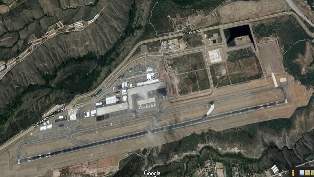
Ecuador - 2.2.1 Quito Mariscal Sucre International Airport (MSIA)
Airport Overview
Mariscal Sucre International Airport (IATA code: UIO; ICAO code: SEQM), also called Tababela Airport, is the international airport of the city of Quito and the main airport in Ecuador. It was officially named in honor of Antonio José de Sucre, hero of Ecuadorian and Spanish American independence. The airport is located on a plain in the eastern suburb of the city of Quito, in the town of Tababela, 25 kilometers from the historic center of the city. The Mariscal Sucre International Airport has the largest passenger movement in the country, and its administration is contracted to the Quiport company.
Quito International Airport is the only one in Latin America and the Caribbean and one of the 17 airports worldwide to have a 5-star rating for service quality by Skytrax, the largest air transport services auditing company. important and prestigious in the world.
|
Airport Location and Contact |
|
|---|---|
|
Country |
Ecuador |
|
Province or District |
Pichincha |
|
Nearest Town or City |
Also known as Tababela airport, is located 18 kilometres (11 miles) northeast of Quito, in the province of Pichincha, about 25 kilometres by road. |
|
Airport’s Complete Name |
Mariscal Sucre International Airport, Quito |
|
Latitude |
-0.113333 |
|
Longitude |
-78.358611 |
|
Elevation (ft and m) |
2,411 m |
|
IATA Code |
UIO |
|
ICAO Code |
SEQM |
|
Managing Company or Airport Authority |
Corporación Quiport S.A. |
|
Management Contact Person |
Ramón Miró, President and General Manager Quiport Daniela Jaramillo, Operations Manager |
|
Open From (hours) |
00:00 |
|
Open To (hours) |
24:00 |
Airport Picture


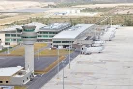
The main areas of the airport are: customs, security office, cargo area, local arrivals, international arrivals.
Description and Contacts of Key Companies
https://www.aeropuertoquito.aero/aerolineas/
|
Aeronautical Safety and Prevention |
|||
|---|---|---|---|
|
Quito |
DIRECTOR DE SEGURIDAD Y PREVENCIÓN AERONÁUTICA, Buenos Aires Oe1-53 y 10 de Agosto Of: 302 Quito, Ecuador |
||
|
Telefono |
+593 02-2552987 |
Fax |
N/A |
|
Telex |
N/A |
AFS |
N/A |
|
|
|||
|
Chief Accident Inspector |
|||
|
Quito |
DIRECTOR DE SEGURIDAD Y PREVENCIÓN AERONÁUTICA, Buenos Aires Oe1-53 y 10 de Agosto Of: 302 Quito, Ecuador |
||
|
Teléfono |
+593 02 2552987 |
Fax |
N/A |
|
Telex |
N/A |
AFS |
N/A |
|
|
Web |
||
|
Customs |
|||
|---|---|---|---|
|
Quito |
Aduanas del Ecuador Arribo internacional, junto a Attenza Duty Free |
||
|
Teléfono |
+593 2 395 4200 ext. 2369 |
Fax |
N/A |
|
Migrations |
|||
|---|---|---|---|
|
Quito |
Policía Nacional, Dirección Nacional de Migración Av. Amazonas N53 - 113 y Japón, Quito, Ecuador |
||
|
Teléfono |
+593 244-7070 |
Fax |
N/A |
|
Ministry of Foreign Affairs |
|||
|---|---|---|---|
|
Quito |
Ministerio de Relaciones Exteriores Carrión E1-76 y Av. 10 de Agosto, Quito, Ecuador |
||
|
Teléfono |
+593 299-3200 |
Fax |
N/A |
|
|
|||
|
Meteorological Service |
|||
|---|---|---|---|
|
Quito |
INSTITUTO NACIONAL DE METEOROLOGIA E HIDROLOGIA Iñaquito N36-14 y Corea, Quito, Ecuador |
||
|
Teléfono |
+593 2 3971100 |
Fax |
N/A |
|
|
Web |
||
|
Ministry of Public Health |
|||
|---|---|---|---|
|
Quito |
Av. Quitumbe Ñan y Av. Amaru Ñan |
||
|
Teléfono |
+593-2 381-4400 |
Fax |
n/a |
|
Quarantine Agriculture |
|||
|---|---|---|---|
|
Quito |
Ministerio de Agricultura, Ganadería, Acuacultura y Pesca Amazonas y Eloy Alfaro, Esquina. Edificio MAGAP, Quito, Ecuador. http://www.magap.gob.ec |
||
|
Teléfono |
+593 2 396-0100 |
Fax |
N/A |
|
National Civil Aviation Council |
|||
|---|---|---|---|
|
Quito |
Consejo Nacional de Aviación Civíl Buenos Aires Oe 1-53 y 10 de Agosto, 4to. Piso |
||
|
Teléfono |
+593 2 2900923 |
Fax |
N/A |
|
Quito International Airport – (MSIA) |
|||
|---|---|---|---|
|
Quito |
Aeropuerto Internacional de Quito - Quiport, PBX: +(593 2) 395-4200 / +(593 2) 395-4300 |
||
|
|
Tel |
+(593 2) 395-4200 ext. 2008/2010 |
|
|
Web |
Fax |
+593 2 294 4948 |
|
FBO Agents Ground Operators Quito Airport
Guayaquil FBO +593 9 9749 1740 (All Ecuador incl. Galápagos)
Jethandling FBO Ecuador +593 99 368 3885
FBO Ecuador +593 99 8838 016
SAEREO - Servicios Aereos Ejecutivos +593 2 3301 152
Ecuacentair +593 2 2818 404
Swissport Ecuador/EMSA +593 2 3957 470
Consorcio Aviation +595 98 1193 063
Talma Ecuador +593 2 281 8052
Passenger and Cargo Performance Indicator
Passenger traffic at the Mariscal Sucre International Airport in Quito registered in 2022, 4.3 million passengers transported on national and international flights, in arrivals and departures.
(Compared to 2019 traffic -before the covid-19 pandemic-, which was more than 5 million passengers, the recovery is 86.4 %.)
The Mariscal Sucre International Airport building occupies 70 hectares of a 1,500 hectare land. It was initially estimated that the 38,000 m2 international passenger terminal would be used by five million passengers per year. The 7,910 m2 national terminal, inaugurated in May 2015, has 10 departure lounges distributed over two levels. The runway is 4,100 meters long, making it the longest runway in Ecuador and any capital in South America. The runway can accommodate the largest aircraft currently available, including the Boeing 747 or the Airbus A380. The construction of a second runway is planned to meet projected demand. The control tower is 41 m high.
|
Performance for 2022 |
|||
|---|---|---|---|
|
Per Year |
Per Month |
Per Day |
|
|
Total Aircraft Movements |
N/A |
- |
- |
|
Total Passengers |
4.3 million (nationals and foreigners; arrivals and departures) |
358,000 |
12,000 |
|
Total Capacity of the Airport (MT) |
N/A |
||
|
Current Activity of the Airport (MT) |
290 677 (TM) [239 109 TM only for exports] |
24,223 |
807.5 |
|
Current use by Humanitarian Flights (UNHAS) |
N/A |
||
The cargo terminal has 13,000 m2, with 10,000 m2 of warehouses and 3,000 m2 of offices carrying out cargo activities. With 24 docks divided into 4 palletizers, the loading waiting area can accommodate up to 24 additional trucks (48 trucks can be in the loading area at the same time). This area has sophisticated scanners and cold rooms.
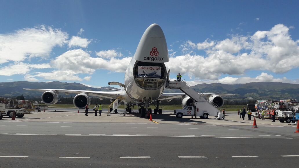
Foto: cortesía https://www.quiport.com/
Runways
This airport has one of the longest runways in Latin America at 4.1 km.
|
Runway #1 |
|
|---|---|
|
Runway Dimensions |
4,100m x 45m |
|
Orientation |
18/36 |
|
Surface |
Draining asphalt |
Helicopter Pad(s)
There is a small space at the Mariscal Sucre International Airport designated for the use of both public and private helicopters. The helicopters and their crews are under the direction of the General Directorate of Civil Aviation.
|
Helipad #1 |
|
|---|---|
|
Present |
Yes |
|
Largest Helicopter that can Land |
Mi-26 |
|
Width and Length (m) |
The helicopters are positioned in the general manoeuvring area |
|
Surface |
Asphalt |
|
Width and Length (m) |
|
|
Surface |
|
Important note: The General Directorate of Civil Aviation (DGAC) inaugurated the 'First Public Heliport in Ecuador' in 2020 at the Monjas Radar Station, in the city of Quito; which is permanently operational.
Public and private aircraft (helicopters) can land at the heliport, as established in Art. 48 of the Codification of the Aeronautical Code.
The landing site is called “Monjas Radar Heliport”, -0.23604, -78.47768 and has all the physical characteristics, visual aids, obstacle limiting surface and wind direction indicator.
Technical characteristics:
Heliport Type: Public.
Hours of Operation: HJ (Sunrise to sunset).
Platform Resistance: 8000 kg.
Visual Aids: Available.
Elevation: 3051.73 meters above sea level.
Airport Infrastructure Details
The Mariscal Sucre International Airport and the Quiport Corporation have obtained the Aerodrome certificate. The certification guarantees that the airport complies with the specifications issued by the International Civil Aviation Organization (ICAO) and the General Directorate of Civil Aviation (DGAC), regarding the facilities and their operation.
|
Customs |
Yes |
JET A-1 fuel |
Yes |
|
Immigration |
Yes |
AVGAS 100 |
Yes |
|
Terminal Building |
Yes |
Single Point Refueling |
Yes |
|
Passenger Terminal |
Yes |
Air Starter Units |
Yes |
|
Cargo terminal |
Yes |
Ground Power (mobile) |
Yes |
|
Pax Transport to Airfield |
Yes |
Ground Handling Services |
Yes |
|
Control Tower |
Yes |
Latrine Servicing |
Yes |
|
Weather Facilities |
Yes |
Fire Fighting Category (ICAO) |
9 |
|
Catering Services |
Yes |
De-icing Equipment |
Yes |
|
Base Operating Room |
Yes |
Parking Ramp Lighting |
Yes |
|
Airport Radar |
Yes |
Approach & Runway Lights |
Yes |
|
NDB |
Yes |
VOR |
Yes |
|
ILS |
Yes |
Yes |
Airport Operating Details
|
Operating Details |
|||
|---|---|---|---|
|
Maximum Sized Aircraft that can be Offloaded on Bulk Cargo |
A340-600 |
||
|
Maximum Sized Aircraft that can be Offloaded on Pallet |
AN-124 |
||
|
Total Aircraft Parking Area (m²) |
Up to 8 positions between MD11 and B747-800 |
||
|
Storage Area (m3 and MT) |
700 m2, there are three warehouses available with cold storage |
||
|
Handling Equipment |
|||
|
Elevators / Hi Loaders |
Yes |
Max Capacity (MT) |
10m |
|
Max Height (m) |
14m |
||
|
Loading Ramps |
6 |
||
|
Other Comments |
|
||
Customs Guidance
Passengers arriving in Ecuador can bring: clothing for personal use, toiletries, medications for personal use and goods for professional use, among other products with their specifications. When the goods exceed the quantity or value on the personal effects list (see link below), the passenger must pay the required taxes. Goods cannot exceed a total value of $2,000 USD. If the total value is greater, the merchandise will go to a temporary storage area and the corresponding tax procedures will be followed. The list of personal effects can be found here: https://www.aduana.gob.ec/viajeros-por-via-aerea-aeropuerto/
Storage Facilities
Centro Perecibles, Cap 250 pallets $0,070 + IVA (12%) + CCFEE
Pertally, Cap 120 pallet $0.070 + IVA (12%) + CCFEE
Aronem Cap 75 pallets $0.070 + IVA (12%) + CCFEE
WAREHOUSE: Mariscal Sucre Quito International Airport

The airport has 3 warehouses with capacity for 445 pallets, complying with all security standards, regulated by the General Directorate of Civil Aviation (DGAC). In addition, they offer cold rooms.
Airfield Costs
Ecuador is the most expensive country for airlines, because it has the highest landing and parking fees in Latin America. On average, an airplane must pay USD 1,751 to cover these items. Quito's Mariscal Sucre International Airport is one of the terminals in the region with the most expensive airport tax, which reaches USD 56.30 per passenger in 2022.
The rates are controlled by the General Directorate of Civil Aviation (DGAC) and paid in its offices and correspond to the following services, among others:
• By the use of the tracks
• For air traffic services
• For meteorological services
• For the inspection and control services of passengers and luggage
• Due to the use, by passengers, of airport areas not accessible to visitors.
• For passenger mobility services and assistance to people with reduced mobility
• Due to the parking of aircraft at airports
• Due to the use of aircraft boarding and disembarkation bridges
• For cargo loading and unloading operations
NAVIGATION CHARGES
International Cargos por Navegación y en Tierra (see Art. 4, 5, 5.1, 7, 8 and 9)
|
Charges |
Aircraft Weight - MTOW (kg) |
||
|---|---|---|---|
|
0 - 7,000 |
7,001 - 136,000 |
136,001 and over |
|
|
Navigation (per journey) USD - $ |
19.30 |
19.30 |
20.06 |
|
Landing USD - $ |
17.43 |
18.75 |
18.88 |
|
Night Landing USD - $ |
4.77 |
4.97 |
5.17 |
|
Night Take-Off USD - $ |
4.77 |
4.97 |
5.17 |
|
Parking |
2.33 |
2.43 |
2.52 |
|
Handling Charges |
N/A |
N/A |
N/A |
FUEL SERVICES CHARGES
|
Price per Litre USD - $ |
|
|---|---|
|
Jet A-1 |
$2.55 US Gallon (entre $0.67 a $0.562 x Litre) |
|
Avgas |
$2.76 US Gallon |
1 US Gallon = 3.8 Liters
Note: In Ecuador Prices vary depending on the type of flight, as can be seen in the following list (updated 08/22/2023):
Commercial AVGAS: €2.04 + VAT (21%)
AVGAS Private: €2.55 + VAT (21%)
JET-A1 Commercial: €1.80 + VAT (21%)
JET-A1 Private: €2.18 + VAT (21%)

CARGO TERMINAL CHARGES
|
Import Charges |
||
|---|---|---|
|
Type of Charge |
Rate USD - $ per kg |
Comments |
|
Handling Charge |
0.26 |
|
|
Break Bulk Fee |
0.26 |
|
|
Diplomatic Mail |
10.00/ 15.00 |
Up to 100 kg |
|
Strong Room – per consignment |
0.26 |
|
|
Cold Storage Fee |
0.26 |
|
|
Delivery Outside Normal Working Hours |
N/A |
|
|
Preparation of substitute AOA – Invoice – Receipt |
N/A |
|
|
Storage per Day |
0.10 |
Grace period N/A |
|
Export |
||
|
Handling Charges – Un-palletized Cargo |
0.10 |
|
|
International Air Waybill |
40.- |
|
|
Local Air Waybill |
25.- |
|
|
Air Way Bill Amendment - Cancellation |
N/A |
|
|
Air Way Bill Documentation |
60 |
|
|
Diplomatic Mail |
25 |
|
|
Storage Charges per Day |
24 hrs 0.10 |
|
AIR-BRIDGE CHARGES
De 0 a 45’ USD 145.60
de 46’ a 180’ USD145.60 + 1.55 x (t= time in minutes)
More than 180’ USD 336.45
Security
EPMSA https://www.aeropuertoquito.gob.ec/ directs, plans, coordinates and controls security operations at the Mariscal Sucre International Airport, in accordance with national and international aeronautical regulations.
Its main task is to guarantee security at the airport through:
• AVSEC inspection for passengers and airport staff
• Inspection of checked and hand luggage.
• Handling of X-ray equipment.
• Control in metal detector arches.
• Closed circuit television control
Ecuador - 2.2.2 José Joaquín de Olmedo International Airport(Guayaquil)
Airport Overview
José Joaquín de Olmedo International Airport (Aeropuerto Internacional José Joaquín de Olmedo in Spanish) is located 5 km north of Guayaquil, the largest and most populous city in Ecuador. It has a runway of 2,790 meters (9,154 ft) and an elevation of 5 meters (16 ft). Together with the Quito airport, it handles most of Ecuador's national and international flights. During 2019, around 4 million passengers passed through the airport. The airport is capable of serving up to 7.5 million passengers per year.
The airport is on Avenida de las Américas, 5 kilometers (3.1 mi) north of downtown Guayaquil. The runway length of 2,684 meters (9,150 ft) includes a 240-meter (790 ft) displaced threshold on Runway 21 and a 100-meter (330 ft) displaced threshold on Runway 03. The airport is in the wide delta of the Guayas River, with level terrain in all quadrants. The parking platform is made of concrete about 35 cm thick and 600 meters long by 80 meters wide, which has an area of 48,000 m², has an asphalt strip for access and a vehicular street, all built in compliance with the established norms. by the General Directorate of Civil Aviation (DGAC) and the International Civil Aviation Organization (ICAO).
The Daular International Airport is a proposed development project for the Ecuadorian city of Guayaquil. The new airport is intended to replace the current José Joaquín de Olmedo Airport once completed. The master plan for the Guayaquil International Airport contemplates moving the airport facilities to a nearby 2,020 hectare plot of land. The new airport, whose construction is planned for 2024 with an estimated investment of 800 million dollars, will have three runways and will be able to serve 16 million passengers per year. However, the new Daular intercontinental airport (26 kilometers from the city) will not be inaugurated in 2024, as initially planned. The plans were affected by the drop in the number of passenger arrivals at the current José Joaquín de Olmedo airport. The entire project consists of two parallel runways of 4,100 and 2,500 meters in length and 36 boarding gates
|
Airport Location and Contact |
|
|---|---|
|
Country |
Ecuador |
|
Province or District |
Guayas |
|
Nearest Town or City |
El aeropuerto está a 7 km del centro y a 1,3 km de la Terminal Terrestre. En auto se tarda 20 minutos en llegar al centro de Guayaquil. |
|
Airport’s Complete Name |
Aeropuerto Internacional José Joaquín de Olmedo |
|
Latitude |
-2.147646 |
|
Longitude |
-79.885222 |
|
Elevation (ft and m) |
6m (19.68 ft) |
|
IATA Code |
GYE |
|
ICAO Code |
SEGU |
|
Managing Company or Airport Authority |
TAGSA – Terminal Aeroportuaria de Guayaquil S. A |
|
Management Contact Person |
Pablo Pita Gerente de Aeropuerto Guayaquil |
|
Open From (hours) |
00:00 |
|
Open To (hours) |
24:00 |
Airport Picture

The existing area of the Guayaquil International Airport is severely limited due to urban congestion.


Source: www.universalweather.com Map not to scale. Not suitable for navigation purposes.

Description and Contacts of Key Companies
Aeropuerto de Guyaquil contactos generales TAGSA Contactos
Aeropuerto Contacto Entidades TAGSA Entidades
FBO Handlers, Ground Operators, Guayaquil Airport
Swissport Ecuador/EMSA +593 4 2590 266
Aeromilitec +593 4 2283 359
SAEREO - Servicios Aereos Ejecutivos +593 2 3301 152
Consorcio Aviation +595 98 1193 063
Jethandling FBO Ecuador +593 99 368 3885
FBO Ecuador +593 99 8838 016
Guayaquil FBO +593 9 9749 1740
Among the airport handling services offered by FBO aviation companies are: ground assistance to aircraft, exclusive services for passengers or crew, which can be carried out even in premises adjacent to the airport terminals, aircraft cleaning, catering, refueling, luggage loading or positioning of aircraft in hangars, among others.
Passenger and Cargo Performance Indicator
Guayaquil Airport is the second busiest airport in Ecuador after Quito's Mariscal Sucre Airport. The airport has a runway and a terminal with capacity for 7.5 million passengers per year. A new airport is currently being built 40 kilometers/25 miles from the city center, called Guayaquil Daular Airport. The airport is expected to become operational in 2026 and will have a capacity of 16 million passengers per year.
|
Performance for 2022 |
|||
|---|---|---|---|
|
Per Year |
Per Month |
Per Day |
|
|
Total Aircraft Movements |
Information not available |
- |
- |
|
Total Passengers |
3,746,554 (The airport is capable of serving up to 7.5 million pax/year) |
290,000 |
9660 |
|
Total Capacity of the Airport (MT) |
74,000 |
||
|
Current Activity of the Airport (MT) |
29,310 |
2443 |
81.4 |
|
Current use by Humanitarian Flights (UNHAS) |
N/A |
_ |
_ |
https://www.ecuadorencifras.gob.ec/institucional/home/
International entry and exit of cargo by air, period 2022 (Thousands of TM)

Among the most relevant aspects, the passenger traffic at the “José Joaquín de Olmedo de Guayaquil” International Airport, which registered a total of 3,477,592 people who moved through the air terminal and its cargo movements transported 33,150.25 MT ( Metric Tons).

Runways
The Guayaquil airport has a single runway designated as Runway 03/21. The runway is 2,684 m long and 45 m wide and is covered with an asphalt surface. It can accommodate large aircraft such as Boeing 747, MD-11 and Airbus A340-600. The airport has a single taxiway 2,935 m long and 23 m wide. Parking spaces are planned for passenger aircraft with seven boarding bridges, eight for cargo airships and seven for general aviation aircraft.
|
Runway #1 |
|
|---|---|
|
Runway Dimensions |
9154 × 151 ft (2,684 m × 46 m) |
|
Orientation |
03/21 |
|
Surface |
All-weather asphalt that meets ICAO standards |
Helicopter Pad

A small space in the airport is designated for the use of helicopters from public or private companies. HELO Aepto GYE Both the helicopters and the crew are controlled by the General Directorate of Civil Aviation.
|
Helipad #1 |
|
|---|---|
|
Present |
Yes |
|
Largest Helicopter that can Land |
Mi-26 |
|
Width and Length (m) |
N/A |
|
Surface |
All-weather asphalt that meets ICAO standards Concrete PCN: 88/R/C/W/T |
Airport Infrastructure Details
Infrastructure/facilities of the Guayaquil International Airport
- Tracks
- Taxiways
- Aprons
- Sewer system
- Energy and public services
- Terminals
- Air traffic control towers
- Charging facilities
- Aircraft hangars
- Fixed base operations
- Roads
- Parking facilities
In 2019, the Guayaquil Airport received from the General Directorate of Civil Aviation the “Aerodrome Certificate” with which the aeronautical authority certifies that GYE, SEGU comply with and comply with all aeronautical regulations related to the air zone or manoeuvre area specified by ICAO and the General Directorate of Civil Aviation Ecuador (DGAC).
|
Customs |
Yes |
JET A-1 fuel |
Yes |
|
Immigration |
Yes |
AVGAS 100 |
Yes |
|
Terminal Building |
Yes |
Single Point Refueling |
Yes |
|
Passenger Terminal |
Yes |
Air Starter Units |
Yes |
|
Cargo terminal |
Yes |
Ground Power (mobile) |
Yes |
|
Pax Transport to Airfield |
Yes |
Ground Handling Services |
Yes |
|
Control Tower |
Yes |
Latrine Servicing |
Yes |
|
Weather Facilities |
Yes |
Fire Fighting Category (ICAO) |
9 |
|
Catering Services |
Yes |
De-icing Equipment |
Yes |
|
Base Operating Room |
Yes |
Parking Ramp Lighting |
Yes |
|
Airport Radar |
Yes |
Approach & Runway Lights |
Yes |
|
NDB |
Yes Ident R |
VOR |
Yes Ident GYV |
|
ILS |
Yes |
Airport Operating Details
|
Operating Details |
|||
|---|---|---|---|
|
Maximum Sized Aircraft that can be Offloaded on Bulk Cargo |
Antonov AN-225, AN-124, Ilyushin IL-76 |
||
|
Maximum Sized Aircraft that can be Offloaded on Pallet |
Boeing 747-400, Airbus A340-600, B777-300 |
||
|
Total Aircraft Parking Area (m²) |
48,000 m², (600 m x 80 m) |
||
|
Storage Area (m3 and MT) |
150 MT |
||
|
Handling Equipment |
|||
|
Elevators / Hi Loaders |
Yes |
Max Capacity (MT) |
15. m |
|
Max Height (m) |
N/A |
||
|
Loading Ramps |
Yes 8 Ramps |
||
|
Other Comments |
Platforms: There are 15 parking spaces. 8 aircraft parking positions for passengers with 10 boarding bridges (these positions have variants according to the type of aircraft operated). 8 aircraft parking spaces for cargo (remote). 7 aircraft parking spaces for general aviation. |
||
Customs Guidance
|
SubDirector : |
Miguel Ángel Villacís Álava |
|---|---|
|
Dirección : |
Av de las Américas, terminal de carga aérea – edificio TCE |
|
Código Postal : |
090505 |
|
Teléfonos : |
(593-4) 2924454 |
|
Horario de atención: |
08h00 – 17h00 |
People arriving in Ecuador must consider that they can enter with clothing used by the traveler, toiletries, medications for personal use, goods for professional use, among other products with their specifications. When the assets exceed the amount or value on the list of personal effects, they are used to pay taxes. The total of these goods may not exceed $2,000. If the amount is greater, the merchandise will be placed in a temporary warehouse to continue the corresponding process.
Check the list of personal effects by entering: https://www.aduana.gob.ec/viajeros-por-via-aerea-aeropuerto/ .
Storage Facilities
|
Guayaquil – Warehousing (US$) |
||
|---|---|---|
|
Facility |
General Air |
TAGSA |
|
Cap |
50 Pallets |
30 Pallets |
|
Charges |
$0.090 + IVA (12%) + CCFEE |
$0.010 + IVA (12%) + CCFEE |
The airport has 2 warehouses with capacity for 80 pallets, complying with all the safety standards regulated by the General Directorate of Civil Aviation (DGAC). In addition, they offer cold chain cold chambers.
Airfield Costs
Ecuador is the most expensive country for airlines, because it has the highest landing and parking fees in Latin America. On average, an airplane must pay USD 1,751 to cover these items.
The airport tax charged at the José Joaquín de Olmedo Airport in Guayaquil is USD 28.50 per traveler.
The airport charges regulated rates for the following services, among others:
• By the use of the tracks
• For air traffic services
• For meteorological services
• For the inspection and control services of passengers and luggage
• Due to the use, by passengers, of airport areas not accessible to visitors.
• For passenger mobility services and assistance to people with reduced mobility
• Due to the parking of aircraft at airports
• Due to the use of aircraft boarding and disembarkation bridges
• For cargo loading and unloading operations
NAVIGATION CHARGES
International, Navigation and Land Charges Internacional Cargos Navegación
(ver Art. 4º, 5º, 5.1, 7º, 8º and 9º)
|
Charges |
Aircraft Weight - MTOW (kg) |
||
|---|---|---|---|
|
0 - 7,000 |
7,001 - 136,000 |
136,001 and over |
|
|
Navigation (per journey) USD - $ |
17.87 |
17.87 |
18.17 |
|
Landing USD - $ |
7.76 |
8.06 |
8.06 |
|
Night Landing USD - $ |
10.10 |
10.10 |
10.10 |
|
Night Take-Off USD - $ |
10.10 |
10.10 |
10.10 |
|
Parking |
1.16 |
1.22 |
1.22 |
|
Handling Charges |
N/A |
|
|
International operations
For the collection of fees for flight protection services for large and small aircraft in international operations, the following charges are established:
A) Flight Protection Rights before and after the route (approach and takeoff):
Base: Maximum takeoff weight
MTOW (In tons) Charge per ton (In USD)
More than 5.7 up to 50 2.23
From more than 50 to 100 2.32
From more than 100 to 150 2.42
From more than 150 2.52
FUEL SERVICES CHARGES
|
Price per Litre USD - $ |
|
|---|---|
|
Jet A-1 |
$2.55 US Gallon (from $0.67 to $0.562 x Litro) |
|
Avgas |
$2.76 US Gallon |
1 US Gallon = 3.8 Liters
Note: In Ecuador Prices vary depending on the type of flight, as can be seen in the following list (updated 08/22/2023):
AVGAS Commercial: €2.04 + VAT (21%)
AVGAS Private: €2.55 + VAT (21%)
JET-A1 Commercial: €1.80 + VAT (21%)
JET-A1 Private: €2.18 + VAT (21%)

At the José Joaquín de Olmedo Airport terminal in Guayaquil, about 162,000 gallons of JET A-1 fuel are pumped daily, the same fuel used in the aeronautical industry and designed for airplanes powered by gas turbine engines. The fuel travels underground through pipes from Plant 1 of Ecuafuel to the aircraft platforms, where a network of hydrants is installed. From this network, the supply equipment is attached to the wing of the aircraft where the fuel tanks are located. operation is called Into Plane.
CARGO TERMINAL CHARGES
|
Import Charges |
||
|---|---|---|
|
Type of Charge |
Rate USD - $ per kg |
Comments |
|
Handling Charge |
0.09 |
The indicated values are referential, it is necessary to request a current quote |
|
Break Bulk Fee |
0.09 |
|
|
Diplomatic Mail |
0.09 |
|
|
Strong Room – per consignment |
0.09 |
|
|
Cold Storage Fee |
0.09 |
100 kg max. |
|
Delivery Outside Normal Working Hours |
N/A |
|
|
Preparation of substitute AOA – Invoice – Receipt |
N/A |
|
|
Storage per Day |
0.09 |
N/A |
|
Export |
||
|
Handling Charges – Un-palletized Cargo |
0.09 |
|
|
International Air Waybill |
40.00 |
|
|
Local Air Waybill |
25.00 |
At market value. Consult in advance with the shipper or agent to establish the current value |
|
Air Way Bill Amendment - Cancellation |
N/A |
|
|
Air Way Bill Documentation |
57.00 |
|
|
Diplomatic Mail |
25.00 |
|
|
Storage Charges per Day |
24 hrs 0.03 |
|
AIR-BRIDGE CHARGES
From 0 a 45’ De 46’ a 180’ More than 180’
USD 134 134.57 + 1.45 x (t=time in mins) 335.91
Security
TAGSA, the managing entity of the Guayaquil Airport, through qualified technical personnel, carries out inspections and controls in the different areas of the airport to prevent risk factors that may generate accidents or affect the health of workers, as part of Health and Safety. . Management System of the José Joaquín de Olmedo International Airport, according to the legal framework
Rescue and firefighting:
• Protection category: 9.
• Critical aircraft: Boeing 767-300.
• Operational personnel: Aeronautical firefighters, radio operators, SEM (Emergency Medical Service) personnel.
• 24 hours, 365 days a year.
Operational equipment:
• 2 OSHKOSH T-12 brand self-pumps: Capacity of 3170gl of water and 410gl of AFFF.
• 1 OSHKOSH T-1500 brand self-pump: Capacity of 1500gl of water, 190gl of AFFF and 500lb of PQS.
• 1 OSHKOSH T-2500 brand self-pump: Capacity of 2500gl of water, 410gl of AFF and 500lb of PQS; It has a hydraulic arm (Snoozle) that penetrates the aircraft fuselage, unique in South America.
• 1 Ford-350 rapid intervention team: Capacity of 500lbs of PQS, 94gl of water and 6gl of 6% foam concentrate.
• 1 logistical support van.
• 1 all-terrain logistical support vehicle in charge of towing the triage trailer
• 2 ambulances
• 1 triage trailer equipped with first aid kits, oxygen, stretchers, etc. to serve our critical aircraft considering up to 250 passengers
Ecuador - 2.2.3 Eloy Alfaro International Airport (Manta)
Airport Overview
The “Eloy Alfaro” International Airport serves the city of Manta, Ecuador (IATA: MEC, ICAO: SEMT). The airport is a mixed-use facility, operating civilian and military air services. It is designated as the alternate airport to Quito and Guayaquil airport. At present, this Manabi airport remains operational with the Quito-Manta-Quito routes, with the service of the Latam and Avianca Airlines. Recently remodeled after a long wait after the 2016 earthquake the Manta International Airport has a new 5,000 square meter terminal, a new nine-story high control tower, parking for more than 130 vehicles, an aircraft parking platform of more than 14,000 square meters, a new access road and additional works that became operational in February 2021 with passengers on the Quito - Manta - Quito route.
Korea Airports Corporation KAC signed a contract with the Ecuadorian government at the end of June 2021 to take on full ownership of Manta Airport and the incorporation for the next 30 years (2021-2050). This will be KAC’s first overseas airport among the 15 airports the firm operates.
The airport, also known as Eloy Alfaro Air Base, is the fourth-busiest airport in Ecuador. Due to its strategic location, the Eloy Alfaro Air Base and the Manta Naval Air Station operate on the runway of this airport. The military air force base is located in an area attached to the provisional passenger air terminal of the International Airport. A portion of the airport was used until July 2009 by the Air Forces Southern Air Force component of the United States Southern Command, for operations against drug trafficking in north western South America. Buildings and platforms were built for the use of the US military and runway 05/23 was rebuilt using more resistant material in order to support the operations of the world's heaviest aircraft, both civil and military.
Later the Ecuador and U.S. governments did not to renew the military airport agreement that allows access and use of the base and in 2009 US forces left the facilities.
|
Airport Location and Contact |
|
|---|---|
|
Country |
Ecuador |
|
Province or District |
Manabi |
|
Nearest Town or City with Distance from Airport |
Manta (2.5 km) |
|
Airport’s Complete Name |
Eloy Alfaro International Airport |
|
Latitude |
-0.953341 |
|
Longitude |
-80.683924 |
|
Elevation (ft and m) |
15 m / 48 feet |
|
IATA Code |
MEC |
|
ICAO Code |
SEMT |
|
Managing Company or Airport Authority |
Direccion General De Aviacion Civil Managing Company: Korea Airports Corporation (KAC) 78, Haneul-gil, Gangseo-gu, Seoul, 07505 Landline 1661-2626 |
|
Management Contact Person |
Chang-wan Son, CEO Korea Airport Corp. |
|
Open From (hours) |
TBD |
|
Open To (hours) |
- |
Airport Picture

Source: www.eluniverso.com, passenger terminal at Manta airport. Photo: Neptalí Palma


Description and Contacts of Key Companies
- The Korea Airports Corporation (KAC) is a Korean state firm that manages 15 international airports, including Manta International Airport.
- UN789 Ocean Airway. This is the name given to the Manta - Tahiti Airway. This airway connects the Asia Pacific region to the South American Region; that is, from Tahiti (French Polynesia) - Tahiti International Airport (NTAA), to Ecuador - Manta International Airport (SEMT) on the northwest coast of Ecuador, being the most salient geographical point towards Asia from South America.

Source: revistademanabi.com Joselías Sánchez Ramos, 2021
Passenger and Cargo Performance Indicator
Not available.
Runway
|
Runway #1 |
|
|---|---|
|
Runway Dimensions |
2860 m X 45 m |
|
Orientation |
05/23 |
|
Surface |
Asphalt |
| Condition | Good |
The runway 05/23 was rebuilt using more resistant material in order to support the operations of the world's heaviest aircraft, both civil and military.
Helicopter Pad(s)
Yes. Manta Naval Air Station and Base Militar Manta. Information is unavailable.
Airport Infrastructure Details
Recently remodeled after a long wait after the 2016 earthquake, the Manta International Airport has a new 5,000 square meter terminal, a new nine-story high control tower, parking for more than 130 vehicles, an aircraft parking platform of more than 14,000 square meters, a new access road and additional works that became operational in February 2021 with passengers on the Quito - Manta - Quito route.
Airport Operating Details
|
Operating Details |
|||
|---|---|---|---|
|
Maximum Sized Aircraft that can be Offloaded on Bulk Cargo |
Antonov AN-225, AN-124, Ilyushin IL-76 |
||
|
Maximum Sized Aircraft that can be Offloaded on Pallet |
Boeing 747-400, Airbus A340-600, B777-300 |
||
|
Total Aircraft Parking Area (m²) |
N/A |
||
|
Storage Area (m3 and MT) |
N/A |
||
|
Handling Equipment |
|||
|
Elevators / Hi Loaders |
N/A |
Max Capacity (MT) |
N/A |
|
Max Height (m) |
N/A |
||
|
Loading Ramps |
N/A |
||
|
Other Comments |
Airport construction is in progress. |
||
Storage Facilities
N/A
Airfield Costs
Navigation Charges
N/A
Fuel Service Charges
The only fuelling station is Ecuafuel , the station belongs to PETROECUADOR, an Ecuadorian state company. In this station large amount of fuel is available.
|
Price per Litre USD - $ |
|
|---|---|
|
Jet A-1 |
0.56 (*) |
|
Avgas |
0.13 (*) |
(*) The above are referential prices and were obtained from Petrocomercial information (GoE fuel supplier). In the private sector, each retailer may vary its prices.
Cargo Terminal Charges
Airport construction is in progress.
Air-Bridge Charges
N/A
Security
N/A
Ecuador - 2.2.4 Mariscal La Mar International Airport (Cuenca)
Airport Overview
Mariscal La Mar International Airport (IATA code: CUE, ICAO code: SECU), also called Mariscal Lamar Airport or Cuenca Airport, is considered a national cross-border terminal located within the urban perimeter of the city of Cuenca, providing its services to the city of Cuenca, Quito and Guayaquil in Ecuador. Local flights take 35 minutes from Quito and 20 minutes from Guayaquil.
Currently, and due to the unexpected growth of the city and its progressive expansion, the airport has been surrounded by industrial and residential areas, which produces tension between the neighbors and the airport entities, due to the constant discomfort due to the noise generated by the planes at the airport. take off and landing. Furthermore, expansions are made impossible due to geography and the surrounding populations; This puts entities in a serious dilemma, since the airport and its runways need to be expanded again due to their air traffic.
The airport has carried out several works that have allowed it to maintain its operations safely and up to date with current aeronautical trends. For example, new satellite and GPS landing procedures have been implemented in approach systems that allow more environmentally friendly operations with lower visibility. It also has an ILS landing system, PAPI and runway lights.
Master Plan and International Airport Certification
In 2022, the Municipality of Cuenca carried out the comprehensive rehabilitation of the runway and movement area of the Mariscal La Mar airport, as well as the repowering and construction of a new drainage system; the reconstruction of electrical circuits, the change to LED lights and the horizontal signage currently in use (The current landing assistance system (ILS) was installed in 2002, which allowed the airport to extend its hours and increase the number of landings in bad weather). These improvements, according to CORPAC, are part of a certification process that this aerodrome seeks and is included in the strategic, institutional and master plans.
Other mandatory improvements are the implementation of immigration and customs measures for daily flight control, which would currently be limited by the physical spaces of the airport.
Incentives
Corpac considers that despite the current geographical and demographic limitations, the Cuenca Airport is an interesting option for companies that operate smaller aircraft (e.g. Dash8 20,000 kg, Fokker F28 30,000 kg), aircrafts that require a shorter runway length and parking platform In this perspective, the government of Ecuador grants to terminals not commissioned in private concession, among others:
- A 40% fuel subsidy for international airlines and,
- The reduction of the EcoDelta* rate from US$50 to US$5
(*) The Ecodelta rate, of USD 50, is charged on international tickets from Ecuador to abroad. On the other hand, the Ecuador Tourist Power tax is charged on international tickets from abroad to Ecuador.
About International Airport Certification
Within the framework of the airport's development and certification master plan, three specific points should be highlighted at this time:
- Anti-narcotics and migration units are installed at the Mariscal La Mar International Airport. https://www.ministeriodelinterior.gob.ec/aeropuerto-de-cuenca-se-internacionaliza-e-implementa-unidades-de-antinarcoticos-y- migration/ September 14, 2023
- However, Corpac recognizes that, if certification is obtained, the operation of international airlines in the city will be conditioned by three limitations that the airport has. The first is the size of the track, just 1,900 meters long. The second consists of the limited space on both sides of the track of just 50 and 80 meters. Ecuadorian regulations say that airfields must have 140 meters of space on the sides of the runway. Third, the location of the air terminal in a densely populated area and in the future the impossibility of expanding it due to the highly limiting mountainous geography of the area.
- The DGAC Ecuador, at the time of publication of this document, considers the Mariscal La Mar Airport, Cuenca as a National Aerodrome.

|
Airport Location and Contact |
|
|---|---|
|
Country |
Ecuador |
|
Province or District |
Azuay |
|
Nearest Town or City |
Cuenca (3.8 km) |
|
Airport’s Complete Name |
Mariscal La Mar International Airport |
|
Latitude |
-2.889678 |
|
Longitude |
-78.987095 |
|
Elevation (ft and m) |
2.532 m / 8.306 feet |
|
IATA Code |
CUE |
|
ICAO Code |
SECU |
|
Managing Company or Airport Authority |
Corporación Aeroportuaria de Cuenca (CORPAC) http://www.aeropuertocuenca.ec/ |
|
Management Contact Person |
José Luis Aguilar Executive Director (May 2023) (Experience: Ministry of Transportation and Public Works, deputy minister of transport services) 593) 7286-7120 / (593) 72862095 |
|
Open From (hours) |
From Saturday to Thursday 06:00 a.m. to 9:30 p.m. Friday from 6:00 a.m. to 10:00 p.m. |
|
Open To (hours) |
_ |
Airport Picture

Photo: www.aeropuertocuenca.ec
The airport is located 2,532 meters above sea level with a reference temperature of 24 degrees Celsius. The airport's operation starts at 11:00 UTC to 02:00 UTC every day of the year, that is, 6:00 and ends at 21:00 in local time UTC-5.

Sourec: @dgac_ecuador
Description and Contacts of Key Companies
Corporate Contacs CORPAC
|
OFFICER |
AREA |
|
|---|---|---|
|
Dr. José Luis Aguilar |
Executive Director |
|
|
Ing. Italo Mogrovejo |
Director of Aerodrome Operations, Engineering and Infrastructure |
|
|
Ing. Marcela Bravo |
Financial Administrative Director |
|
|
Ab. Paul Vazquez |
Legal advisor |
|
|
Lcda. Marcia Rodas |
Security |
FBO Handlers, Ground Operators, Cuenca Airport*
International Flight Planning Solutions- IFPLS
(*) With own operations or service is provided through third parties
Passenger and Cargo Performance Indicator
|
Performance for 2022 |
|||
|---|---|---|---|
|
Per Year |
Per Month |
Per Day |
|
|
Total Aircraft Movements |
N/A |
- |
Cuenca-Quito 52 flights/week Cuenca-Guayaquil 4 flights/week |
|
Total Passengers |
196.530 (1) (2021 103.777) |
16378 |
546 |
|
Total Capacity of the Airport (MT) |
(2) |
||
|
Current Activity of the Airport (MT) |
(3) |
||
|
Current use by Humanitarian Flights (UNHAS) |
No |
||
(1) National Institute of Statistics, Consulted on September 6, 2023
(2) Cargo flights are not planned. The terminal, relatively small, has 5,126 m² of construction on 2 floors, being a completely modern building.
(3) The airport has a rigid pavement platform 250 m long by 50 m wide, parallel to 70 m from the runway axis.
Runways
Total area of 68,400 square meters. At the Northeast and Southwest ends there is an additional area (called ears) of 18,446.00 m². Therefore, the actual total surface area of the track is 86,846.00 m². Headland threshold 0-5: S 02º53``41.0” and W 78º59``28.1” with an elevation of 2531.73 meters (8306.2 feet) above sea level. Head threshold 2-3: S 02º53``03.1 and W 78º58` 39.06” with an elevation of 2516.45 meters (8256.07 feet) above sea level.
The taxiway is built on flexible pavement, parallel to the runway at a distance of 78m. and communicates with the 0-5 head of the airport with a length of 580 m. with a width of 18 m.

Source: zbordirect.com/es/airport/cuenca-cue
Currently, with the growth of the city, the airport is located within the northern area of the city, completely surrounded by it, in a commercial, industrial and residential area. This generates inconvenience, especially due to noise, safety and efficiency problems for airlines and users. Furthermore, although the passenger terminal has been constantly updated and is a modern building, the runway can no longer be expanded because on one side there is a ravine and on the other side several houses and businesses.
|
Runway #1 |
|
|---|---|
|
Runway Dimensions |
1900m x 36m (6,234 × 118 ft) TRACK STRIP: 2020m x 110m SLOPE: ±0.82% |
|
Orientation |
24 N y 06 S |
|
Surface |
Asphalt, flexible |
RunwayRepairs (Nov 2021):
Repair of irregularities on the runway surface, due to the asphalt layer reaching its useful life.
Repair and sealing of cracks (potholes on runway).
Repair in the footprint groove.
Definitive demarcation of the manoeuvre area and movement area with new painting and signage.
Taxi way:
The taxiway is built on flexible pavement, parallel to the runway at a distance of 78 m and communicates with the airport's 0-5 headland with a length of 580 m and a width of 18 m.
CUE conditions:
4.5 km Visibility
250m Ceiling
VFR THRESHOLD 05
IFR THRESHOLD 23 PRN APPROACH THRESHOLD 05
Runway lighting:
12 PAPIS Lights, header 23.
8 PAPIS lights, header 05.
16 Green lights, runway start 05/23.
16 Red lights, end of runway 05/23.
The airport has a rigid pavement platform 250 m long by 50 m wide, parallel to 70 m from the runway axis.
Airport Infrastructure Details
The relatively small terminal has 5,126 m² of construction on 2 floors, being a completely modern building. Currently, with the growth of the city, the airport is located within the northern area of the city, completely surrounded by it, in a commercial, industrial and residential area. This generates inconvenience, especially due to noise, safety and efficiency problems for airlines and users.
|
Customs |
Yes |
JET A-1 fuel |
Yes |
|
Immigration |
Yes |
AVGAS 100 |
Yes |
|
Terminal Building |
Yes |
Single Point Refueling |
Yes |
|
Passenger Terminal |
Yes |
Air Starter Units |
Yes |
|
Cargo terminal |
No cargo flights |
Ground Power (mobile) |
Yes |
|
Pax Transport to Airfield |
No |
Ground Handling Services |
Yes |
|
Control Tower |
Yes |
Latrine Servicing |
Yes |
|
Weather Facilities |
Yes Meteo CUE |
Fire Fighting Category (ICAO) |
|
|
Catering Services |
No |
De-icing Equipment |
No |
|
Base Operating Room |
Yes |
Parking Ramp Lighting |
N/A |
|
Airport Radar |
Yes |
Approach & Runway Lights |
Yes Balizaje CUE |
|
NDB |
Yes |
VOR |
|
|
ILS |
Yes |
Radio aid for navigation and landing: Radioayuda CUE
Airport Operating Details
|
Operating Details |
|
|---|---|
|
Maximum Sized Aircraft that can be Offloaded on Bulk Cargo |
No cargo flights |
|
Maximum Sized Aircraft that can be Offloaded on Pallet |
No cargo flights |
|
Total Aircraft Parking Area (m²) |
The airport has a rigid pavement platform 250 m long by 50 m wide, parallel to 70 m from the runway axis. |
|
Storage Area (m3 and MT) |
No |
Storage Facilities
CUE Airport does not receive cargo flights
Airfield Costs
The Ecodelta rate, of USD 50, is charged on international tickets from Ecuador to abroad. On the other hand, the Ecuador Tourist Power tax is charged on international tickets from abroad to Ecuador.
Ecuador is generally the most expensive country for airlines, because it has the highest landing and parking fees in Latin America. On average, an airplane must pay USD 1,751 to cover these items.
The airport charges regulated rates for the following services, among others:
• By the use of the tracks
• For air traffic services
• For meteorological services
• For the inspection and control services of passengers and luggage
• Due to the use, by passengers, of airport areas not accessible to visitors.
• For passenger mobility services and assistance to people with reduced mobility
• Due to the parking of aircraft at airports
FUEL SERVICES CHARGES
|
Price per Litre USD - $ |
|
|---|---|
|
Jet A-1 |
2.114 / US Gallon ; 0.562 / Litre |
|
Avgas |
N/A |
Video restart of fuel supply service at CUE airport: https://youtu.be/_5UJGaPUy3E
Corpac – FAYTA* http://www.fayta.com.ec/combustibles/ : Fuel types: JET A-1
2 tanks with a capacity of 5000 and 10000 gallons
5 tanks with a capacity of 50 thousand gallons
Condition: Operational
(*)FAYTA S.A. is an Ecuadorian company that markets aviation fuels (Turbo Fuel JP1 and AVGas 100/130), with more than 10 years of experience in the market, has current permits and contracts for the sale and distribution of aviation fuels.
Air Bridge
The airport does not have this equipment
Navigation Charges
Internacional, Cargos por Navegación y en Tierra Internacional Cargos Navegación
(see Art. 4º, 5º, 5.1, 7º, 8º y 9º)
Security
PROHIBITED ITEMS
a) Light firearms, firearms and other projectile-launching devices designed to cause serious injury by launching a projectile, or which can be confused with such devices
b) Stunning devices specifically designed to stun or immobilize:
c) Pointed or sharp-edged objects that can be used to cause serious injury:
d) Work tools that can be used to cause serious injury or threaten the operational safety of the aircraft:
e) Blunt instruments that can be used to cause serious injuries by striking:
f) Explosives and flammable substances and devices that can be used to cause serious injury or threaten the operational safety of the aircraft:
The regulations for obtaining, granting and using the airport circulation card at the Mariscal La Mar airport in the city of Cuenca indicate that: Any person who performs tasks or functions in the aeronautical field, as well as performs commercial acts or provides services. in the restricted security areas of the Mariscal La Mar airport in the city of Cuenca, you must possess the Airport Circulation Card, issued by the Cuenca Airport Corporation.
The TCA is the only document that allows its holder to enter certain sector(s) of the airport facility, according to the area to which they are authorized and which is displayed on the card in a bar of colors and numbers.
Objective: Guarantee the safety of passengers, aircraft users and airport facilities through the application of a control mechanism, with the issuance of the Airport Circulation Card, which regulates the entry and stay of people in the aeronautical part or in the different restricted security areas of the Mariscal Lamar airport in the city of Cuenca.
RESCUE AND FIRE FIGHTING SERVICE
|
1 |
Working Hours |
MON-SUN 1100-0300 |
|
2 |
Fire Fighting Category |
CAT 6 |
|
3 |
Rescue Equipment |
1 OSHKOSH T-1500 1500 gallons of water, 195 gallons of AFFF and 500 pounds of P.Q.S. 1 ROSEMBAUER 3000 3000 gallons of water, 400 gallons of AFFF and 500 pounds of P.Q.S. |
|
4 |
Ability to remove disabled aircraft |
Liability and removal of an aircraft unused correspond to the registered owner or to the operator affected by his own means or agreement with local companies. |
|
5 |
Remarks |
N/A |
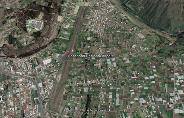
Ecuador - 2.2.5 Chachoan National Airport (Ambato)
Airport Overview
Chachoán airport is only operational during the day.
|
Airport Location and Contact |
|
|---|---|
|
Country |
Ecuador |
|
Province or District |
Tungurahua |
|
Nearest Town or City |
Ambato (6km) |
|
Airport’s Complete Name |
Aeródromo Nacional “Chachoán” |
|
Latitude |
-1.211944 |
|
Longitude |
-78.57444 |
|
Elevation (ft and m) |
8,391 ft / 2,558 m |
|
IATA Code |
ATF |
|
ICAO Code |
SEAM |
|
Managing Company or Airport Authority |
Ministry of National Defense Directorate of Specialized Technical Consulting (DATE) Ecuadorian Air Force |
|
Management Contact Person |
|
|
NGO and/or UN Presence at Airport? |
NO |
Observations: Prior permission from the Ministry of National Defence is required for civil aircraft operations.
Runway
|
Runway #1 |
|
|---|---|
|
Runway Dimensions |
1,925 m x 25 m Runway Side Strip 2042 x 150 m |
|
Runway Orientation |
01/19 |
|
Runway Surface |
SIWL 13636 DW 17273 Pavement, asphalt |
|
Runway Condition |
N/A |
Airport Infrastructure Details
|
Infrastructure |
|||
|---|---|---|---|
|
Passenger / Cargo Security Screening |
No |
Runway Lighting |
No |
|
Refueling Capacity |
No |
Ground Handling Services |
No |
|
Air Traffic Control |
N/A |
Fire Fighting Equipment |
N/A |
|
Weather Information |
Yes 1 |
Aircraft Parking Space |
No |
|
Navigation Aids |
No 2 |
Perimeter Fencing |
No |
|
Windsock |
Yes |
|
|
- Meteo Ambato: INFORMACION_METEOROLOGICA_PROPORCIONADA Ambato
- Nav Aid , NO. Source RADIOAYUDAS_PARA_LA_NAVEGACI.C3.93N_Y_EL_ATERRIZAJE Ambato
Helipad
Si , _AREA_DE_ATERRIZAJE_PARA_HELICOPTEROS Ambato
Fuel Services Charges
N/A
|
Price per Litre USD - $ |
|
|---|---|
|
Jet A-1 |
N/A |
|
Avgas |
N/A |
Royalties / Non Objection Fees (NOFs)
N/A
Ecuador - 2.2.6 Seymour National Airport (Baltra, Galapagos)
Airport Overview
Baltra Seymour Airport, also known as Baltra Airport - Galapagos Islands, is the main airport of the Galapagos Islands archipelago in Ecuador. Seymour Airport is located on the island of Baltra, 23 meters above sea level.
The airport is located 36 km (22 miles) north of Puerto Ayora, capital and main town of the island of Santa Cruz, part of the Galapagos archipelago.
Baltra receives small planes with flights from the main Ecuadorian cities. Some of the airport's main services are X-ray control to prevent trafficking of endemic species, biosecurity and quarantine agencies, medical service, migration, catering, agro-quality and rapid security clearance. In the event of any emergency, the fire station and ambulances have a prompt response.

Entry requirements to the Galapagos Islands by air
All people who want to enter the island province, tourists or residents, have the same requirements:
People over 16 years of age must present a COVID-19 vaccination card valid for at least 14 days after completing the schedule. In addition, the negative result of a qualitative real-time RT-PCR test, carried out up to 72 hours prior to boarding to Ecuador.
Minors between 2 and 16 years of age must present the negative result of a real-time qualitative RTPCR test carried out up to 72 hours prior to boarding.
In the case of national or foreign tourists, they must also present the transit control card issued by the Government Council of the Special Regime of Galapagos, eliminating the safe conduct managed by a tour operator or by an accommodation regulated by the Ministry of Tourism. This provision exempts the safe conduct for tour leaders established in article 12 of the Tourist Guidance Regulations for the Special Regime of the Province of Galapagos.
Ref. DGAC Galápagos por Vía Aérea

Note: Seymour Airport is only operational during the day.
|
Airport Location and Contact |
|
|---|---|
|
Country |
Ecuador |
|
Province or District |
Islas Galápagos |
|
Nearest Town or City |
Baltra |
|
Airport’s Complete Name |
Aeródromo Nacional “Seymour” |
|
Latitude |
-0.444840 |
|
Longitude |
-90.270334 |
|
Elevation (ft and m) |
77 feet / 23 m |
|
IATA Code |
GPS |
|
ICAO Code |
SEGS |
|
Managing Company or Airport Authority |
Aeropuertos Ecológicos de Galápagos - ECOGAL S.A. https://www.ecogal.aero/es/
|
|
Management Contact Person |
Jorge Rosillo Gerente General Jefatura Aeropuerto Baltra Aeródromo de Baltra |
|
NGO and/or UN Presence at Airport? |
No |
Passenger movement at Seymour Airport 2022 231,782 pax. (73,000 pax in 2020)
Runway(s)
|
Runway #1 |
|
|---|---|
|
Runway Dimensions |
2,400 m x 35 m |
|
Runway Orientation |
14/32 |
|
Runway Surface |
65/F/D/X/U Pavement Asphalt |
|
Runway Condition |
Good |
Platform:
Surface: NE Sector: Pavement SW Sector – Concrete, Resistance: PCN: 45/R/D/X/T
Width, surface and resistance of taxiways:
Width: TWY A 59.82 M TWY B 31.77 M
Surface: TWY A Concrete TWY B Pavement
Resistance: TWY A and TWY B
PCN: 65/F/C/X/T
Airport Infrastructure Details
|
Infrastructure |
|||
|---|---|---|---|
|
Passenger / Cargo Security Screening |
Yes |
Runway Lighting |
No |
|
Refueling Capacity |
No |
Ground Handling Services |
No |
|
Air Traffic Control |
Yes |
Fire Fighting Equipment |
Yes 4 |
|
Weather Information |
Yes 1 |
Aircraft Parking Space |
Yes 3 |
|
Navigation Aids |
Yes 2 |
Perimeter Fencing |
No |
|
Windsock |
Yes |
|
|
(1) Meteo Aeropuerto Seymour Meteo Aeropuerto Seymour Teléfono: Teléfono: 593 2 2947400 ext. 2610
(2) Aeronavegación RADIOAYUDAS NAVEGACION ATERRIZAJE Galápagos
(3) Plataforma: Superficie : Sector NE: Pavimento Sector SW – Concreto, Resistencia : PCN: 45/R/D/X/T
(4) Cat 6 Para situaciones de emergencia se interviene mediante convenio entre la Jefatura de aeropuerto y las compañías locales. Equipo de salvamento: 1 OSHKOSH T-3000, 3000 galones de agua, 420 galones de AFFF 500 libras de P.Q.S. Ante cualquier emergencia el parque de bomberos y ambulancias tienen una pronta respuesta.
Helipad
Yes Aterrizaje HELO Galápagos Helipad Strength: Concrete PCN: 45/R/D/X/T
Fuel Services Charges
N/A
|
Price per Litre USD - $ |
|
|
Jet A-1 |
N/A |
|
Avgas |
N/A |
Royalties / Non Objection Fees (NOFs)
N/A
Ecuador - 2.2.7 Francisco de Orellana National Airport (Coca)
Airport Overview
The Francisco de Orellana Airport is located in the capital of the province of Orellana, also known by the name of Coca, due to its proximity to the Coca River. With the General Directorate of Civil Aviation of Ecuador as its operator, it is considered a Type B airport, because it carries out both cargo and passenger flights; In addition, it has a completely paved track 2,060 meters long × 27 meters wide.
The airport is located at an elevation of 834 feet (254 m) above mean sea level. It has a runway designated 15/33 with a flexible pavement surface measuring 6,760 by 90 feet (2,060 × 27 m); and a capacity to receive aircraft weighing more than 100,000 pounds.
Some of the airport's main services are: medical service and expedited security clearance. In the event of any emergency, the fire and ambulance station has a prompt response.
Brief History
The airport was built between 1958 and 1959 by the Vicariate of Aguarico, an ecclesiastical community that has contributed to the development of the region.
With an initial length of 600 meters, and only grass, which only allowed it to operate in summer; It was used to evacuate patients with tropical diseases typical of the area, given that there were no roads that connected this area with the rest of the country. With oil exploitation, the Texaco Company extended the length to a thousand meters, and added a mixture of ballast and crude oil, which gave it a characteristic similar to pavement.
|
Airport Location and Contact |
|
|---|---|
|
Country |
Ecuador |
|
Province or District |
Orellana |
|
Nearest Town or City |
Coca (5 km) |
|
Airport’s Complete Name |
Aeródromo Nacional “Francisco de Orellana” |
|
Latitude |
-0.463693 |
|
Longitude |
-76.985308 |
|
Elevation (ft and m) |
834 feet / 254 m |
|
IATA Code |
OCC |
|
ICAO Code |
SECO |
|
Managing Company or Airport Authority |
General Directorate of Civil Aviation “Francisco de Orellana” National Aerodrome * |
|
Management Contact Person |
+593 6 2883518 |
|
NGO and/or UN Presence at Airport? |
N/A |
(*) The General Directorate of Civil Aviation has been in charge of administration since 1988, and permanently continues with expansion and improvements to the runway and apron, and air terminal.
Passenger movements at Francisco de Orellana Airport 2022: 48,862 pax. (The airport has an installed capacity of up to 100,000 pax / year)

Photo https://www.nlarenas.com/2022/08/aeropuerto-francisco-de-orellana-el-coca/

Runway
|
Runway #1 |
|
|---|---|
|
Runway Dimensions |
2300m x 30m |
|
Runway Orientation |
16/34 |
|
Runway Surface |
Pavement Asphalt :PCN 39/F/C/Y/T |
|
Runway Condition |
N/A |
- 180° turns prohibited on RWY 16/34
- Receives aircraft weighing more than 100,000 pounds/45 tons
Airport Infrastructure Details
With the remodelling carried out in 2018, the new terminal has 4,780 square meters of space and the apron with a capacity for up to 7 aircraft. Additionally, the airport has a landing strip 2,300 meters long by 30 meters wide, a boarding hall for more than 400 passengers, a new control tower 19.7 meters high, counter rooms and service hangars.
|
Infrastructure |
|||
|---|---|---|---|
|
Passenger / Cargo Security Screening |
Yes |
Runway Lighting |
Yes 2 |
|
Refuelling Capacity |
No |
Ground Handling Services |
No |
|
Air Traffic Control |
Yes |
Fire Fighting Equipment |
Yes CAT 6 |
|
Weather Information |
Yes 4 |
Aircraft Parking Space |
Yes 1 |
|
Navigation Aids |
Yes 3 |
Perimeter Fencing |
Yes |
|
Windsock |
Yes |
|
|
(1) Ramp with positions for up to 7 aircraft
(2) Approach and Runway Lights: PAPI Left 3° (253 M / 830 FT)
(3) Type of MAG VAR aid, type of OPS supported (for VOR/ILS/MLS, declination indicated): VOR/DME (5°W/2022) COV ID, NDB COC ID, LOC (5°W/2022 ) ILS CAT I (5°W or 355°) ID ICC, GP 16 DME
(4) COCA associated MET office, Ph. 593 2 2947400 ext. 3515
New facilities
• New Passenger Terminal
• New Control Tower
• New Fire Service Hangar
• Aircraft apron expansion
• Re-distribution of the internal hydrosanitary network
• Storm sewage system
• Exterior works and parking lots
Helipad
Yes, Helicopter Landing Area with two positions:
A) 002741.68S 0765913.02W
B) 002742.03S 0765913.72W
16.5M/54FT
Fuel Services Charges
Coca Airport fuel types: JET A-1 NOT operational
Royalties / Non Objection Fees (NOFs)
N/A
Ecuador - 2.2.8 Coronel Carlos Concha Torres National Airport (Esmeraldas)
Airport Overview
The Colonel Carlos Concha Torres Airport is an airport serving the Pacific coastal city of Esmeraldas, capital of the Esmeraldas Province of Ecuador. It is 3 kilometres (1.9 mi) east of the city, across the Esmeraldas River in the parish of Tachina. Established in 1940 as General Rivadeneira Airport, the airport was renovated between 2012 and 2013, receiving a new terminal and a lengthened runway. Some of the main services of the airport are: medical service and fast-tracked security clearance.
In case of any emergency the fire station and ambulances have a prompt response.
|
Airport Location and Contact |
|
|
Country |
Ecuador |
|---|---|
|
Province or District |
Esmeraldas |
|
Nearest Town or City with Distance from Airport |
Esmeraldas (3 km) |
|
Airport’s Complete Name |
Coronel Carlos Concha Torres Airport |
|
Latitude |
0.977015 |
|
Longitude |
-79.624447 |
|
Elevation (ft and m) |
32 feet / 10 m |
|
IATA Code |
ESM |
|
ICAO Code |
SETN |
|
Managing Company or Airport Authority |
Dirección de Aviación Civil |
|
Management Contact Person |
Jorge Acosta |
|
NGO and/or UN Presence at Airport? |
N/A |


Runway
|
Runway #1 |
|
|
Runway Dimensions |
2,400 m x 45 m |
|---|---|
|
Runway Orientation |
18/36 |
|
Runway Surface |
Asphalt |
|
Runway Condition |
Good condition |
It is 3 kilometres (1.9 mi) east of the city, across the Esmeraldas River in the parish of Tachina.
Airport Infrastructure Details
|
Infrastructure |
|||
|
Passenger / Cargo Security Screening |
Yes |
Runway Lighting |
No |
|---|---|---|---|
|
Refueling Capacity |
Yes |
Ground Handling Services |
Yes |
|
Air Traffic Control |
Yes |
Fire Fighting Equipment |
Yes |
|
Weather Information |
Yes |
Aircraft Parking Space |
Yes |
|
Navigation Aids |
Yes |
Perimeter Fencing |
Yes |
|
Windsock |
Yes |
|
|
The Esmeraldas VOR-DME (Ident: ESV) and non-directional beacon (Ident: ESM) are located on the field.
Fuel Service Charges
Ecuafuel is the fuelling station that belongs to PETROECUADOR, an Ecuadorian state company.
|
|
Price per Litre USD - $ |
|
Jet A-1 |
0.56 |
|---|---|
|
Avgas |
0.13 |
The above are referential prices and were obtained from Petrocomercial information (GoE fuel supplier). In the private sector, each retailer may vary its prices.
Royalties / Non-Objection Fees
N/A
Ecuador - 2.2.9 Nueva Loja National Airport (Lago Agrio)
Airport Overview
The airport has a terminal that can serve 150,000 passengers in a year. In this terminal, different types of airport services are offered: airline counters, restaurants, security points, military presence and nursing. In the external part of the airport there is a parking lot with capacity for about 220 cars, monitored by the local authorities. In terms of capacity, the airport can receive aircraft such as the Hercules C-130 or Boeing 727 without major problems, thanks to its track of 2,300 meters long by 45 wide. The airport has hangars and staff and equipment to provide maintenance for C-130, Boeing 727, Boeing 737 and Airbus A320 aircraft. Some of the main services of the airport are medical service and fast-tracked security clearance. In case of any emergency the fire station and ambulances have a prompt response. Lago Agrio Airport is only operational during daylight hours.
|
Airport Location and Contact |
|
|
Country |
Ecuador |
|---|---|
|
Province or District |
Sucumbios |
|
Nearest Town or City with Distance from Airport |
Lago Agrio (3 km) |
|
Airport’s Complete Name |
Aeropuerto Nueva Loja |
|
Latitude |
0.092445 |
|
Longitude |
-76.866919 |
|
Elevation (ft and m) |
982 feet / 299 m |
|
IATA Code |
LGQ |
|
ICAO Code |
SENL |
|
Managing Company or Airport Authority |
Dirección Nacional de Aviación Civil |
|
Management Contact Person |
Hernan Ojeda |
|
NGO and/or UN Presence at Airport? |
N/A |


Runway
|
Runway #1 |
|
|
Runway Dimensions |
2,307 m x 45 m |
|---|---|
|
Runway Orientation |
05/23 |
|
Runway Surface |
Asphalt |
|
Runway Condition |
Good condition |
Airport Infrastructure Details
|
Infrastructure |
|||
|
Passenger / Cargo Security Screening |
Yes |
Runway Lighting |
No |
|---|---|---|---|
|
Refueling Capacity |
Yes |
Ground Handling Services |
Yes |
|
Air Traffic Control |
Yes |
Fire Fighting Equipment |
Yes |
|
Weather Information |
Yes |
Aircraft Parking Space |
Yes |
|
Navigation Aids |
Yes |
Perimeter Fencing |
Yes |
|
Windsock |
Yes |
|
|
Fuel Services Charges
PETROECUADOR an Ecuadorian state company, provided the fuel service in Lago Agrio.
|
|
Price per Litre USD - $ |
|
Jet A-1 |
0.56 |
|---|---|
|
Avgas |
0.13 |
The above are referential prices and were obtained from Petrocomercial information (GoE fuel supplier). In the private sector, each retailer may vary its prices.
Royalties / Non Objection Fees (NOFs)
N/A
Ecuador - 2.2.10 Latacunga International Airport (Cotopaxi)
Airport Overview
Cotopaxi International Airport is a high elevation airport in Latacunga, the capital of the Cotopaxi Province in Ecuador. The airport is within a broad valley of the Ecuadoran Andes, with rising terrain east and west, and mountainous terrain distant in all quadrants. Cotopaxi International Airport is operational from 1045 – 0500.
It has the second longest runway in Ecuador. Runway length includes a 440 metres (1,440 ft) displaced threshold on the runway.
|
Airport Location and Contact |
|
|---|---|
|
Country |
Ecuador |
|
Province or District |
Cotopaxi |
|
Nearest Town or City |
Latacunga |
|
Airport’s Complete Name |
Aeropuerto Internacional de Latacunga |
|
Latitude |
00° 54' 24.60" S |
|
Longitude |
078° 36' 56.72" W |
|
Elevation (ft and m) |
2.806 m / 9.205 feet |
|
IATA Code |
LTX |
|
ICAO Code |
SELT |
|
Managing Company or Airport Authority |
Dirección Nacional de Aviación Civil |
|
Management Contact Person |
Carlos Vivas |
|
NGO and/or UN Presence at Airport? |
N/A |
Airport Pictures


Runway(s)
|
Runway #1 |
|
|---|---|
|
Runway Dimensions |
Length 3693 m x Width 45 m |
|
Runway Orientation |
18/36 |
|
Runway Surface |
Asphalt |
|
Runway Condition |
Good condition |
Airport Infrastructure Details
|
Infrastructure |
|||
|---|---|---|---|
|
Passenger / Cargo Security Screening |
Yes |
Runway Lighting |
Yes |
|
Refueling Capacity |
Yes |
Ground Handling Services |
Yes |
|
Air Traffic Control |
Yes |
Fire Fighting Equipment |
Yes |
|
Weather Information |
Yes |
Aircraft Parking Space |
Yes |
|
Navigation Aids |
Yes |
Perimeter Fencing |
Yes |
|
Windsock |
Yes |
|
|
Fuel Services Charges
The only fuelling station is Ecuafuel , the station belongs to PETROECUADOR, an Ecuadorian state company. In this station large amount of fuel is available.
|
Price per Litre USD - $ |
|
|---|---|
|
Jet A-1 |
0.56 |
|
Avgas |
0.13 |
The above are referential prices and were obtained from Petrocomercial information (GoE fuel supplier). In the private sector, each retailer may vary its prices.
Ecuador - 2.2.11 Catamayo National Airport (Loja)
Airport Overview
The Catamayo City Airport is the only airport that serves the entire province of Loja with more than 511,000 inhabitants. The airport is only operational during daylight hours, receiving a total of 68 regular flights monthly, of which 60 are from Quito and 8 from Guayaquil, reaching up to 3 daily flights. In 2022 a total of 64.685 passengers flew in/out the terminal, (Ref, 2021 33,577; 2020 20,955)
The airport is located a city in mountain valley 18 kilometres (11 mi) west of Loja. There is rising terrain south of the airport, and mountainous terrain in all other quadrants. Some of the main services of the airport are a medical Service and fast-tracked security clearance.
Approaching and landing can only be made on runway 07 and takeoffs on runway 25, which makes its operation more complex, which together with the climate and mountains is a challenge for the pilots, who are specially trained to land there. The location of the runway does not allow the development of an instrument flight procedure to get there in bad weather. Very intense winds in certain times of the year is another limitation that does not allows any operation to be carried out on either of the two tracks, added to the irregular topography of the terrain.
|
Airport Location and Contact |
|
|---|---|
|
Country |
Ecuador |
|
Province or District |
Loja |
|
Nearest Town or City |
Catamayo |
|
Airport’s Complete Name |
Aeropuerto Ciudad de Catamayo |
|
Latitude |
035945S |
|
Longitude |
0792219W |
|
Elevation (ft and m) |
1238 m / 4,056 feet |
|
IATA Code |
LOH |
|
ICAO Code |
SECA |
|
Managing Company or Airport Authority |
Dirección General de Aviación Civil Aeródromo Nacional “Ciudad de Catamayo” |
|
Management Contact Person |
Jefatura Aeropuerto Catamayo Ph: +593 7 2677310 |
|
NGO and/or UN Presence at Airport? |
No |
The Catamayo Airport, began its operations with the application of the RNAV instrument approach procedure, with support from the GNSS satellite system (Global Navigation Satellite System), used for the approach and landing of aircraft. . Previously, the approach was carried out only in VFR flight conditions, that is, with visual reference to the terrain.
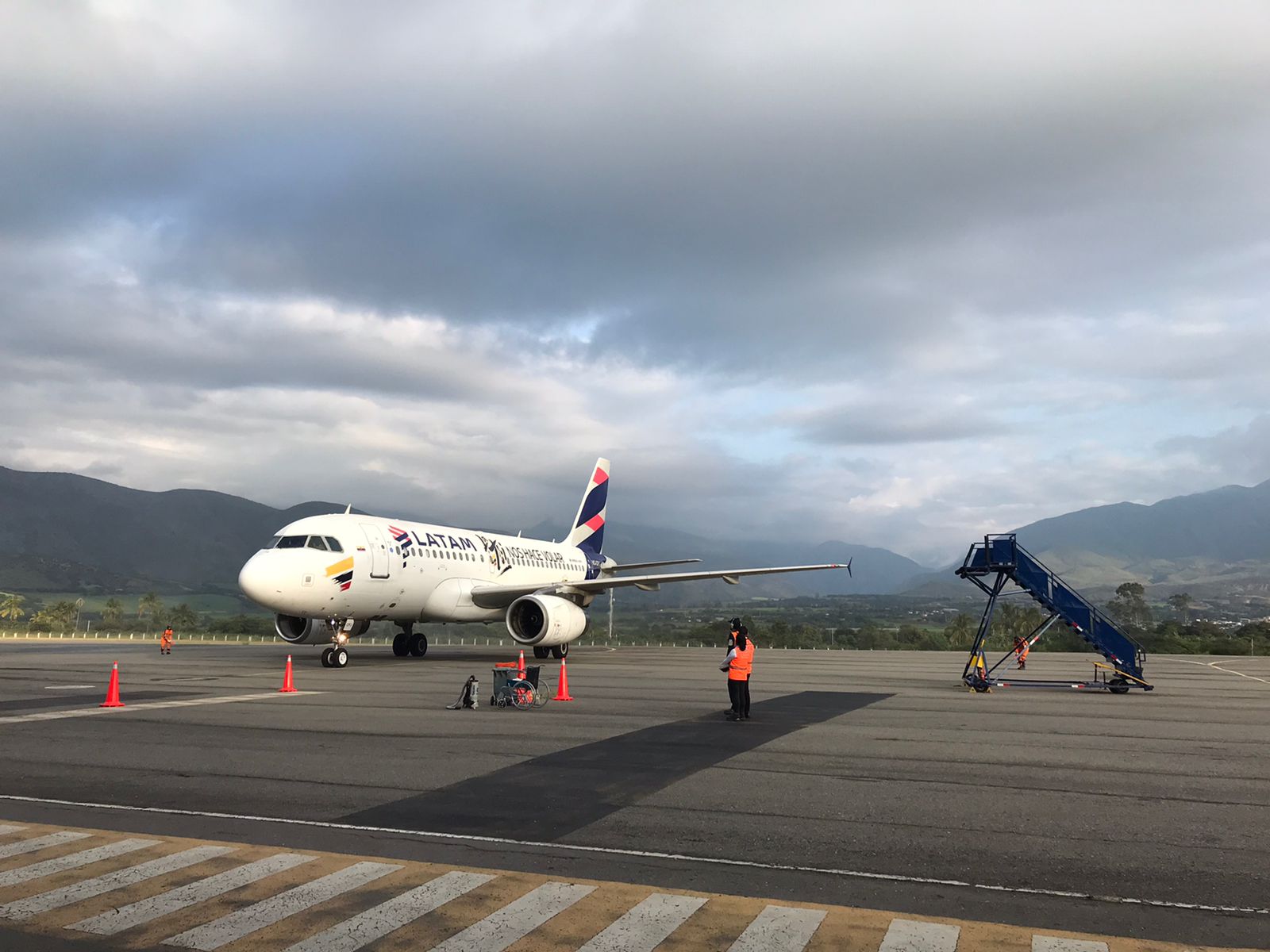
The General Directorate of Civil Aviation, through the Directorate of Air Navigation Services, began the process of implementing this procedure, a year ago, together with the air operator LATAM, to take advantage of the avionics technology that will be used by the Airbus 319 aircraft said the airline, on the Quito-Loja-Quito route.
During this process, the Air Traffic Control (ATC) personnel of the control tower of the Catamayo air terminal were trained. In addition, technical coordination was carried out regarding the type of navigation, approach and takeoff with ATC personnel from the Guayaquil Area Control Center (ACC) and ATC personnel from the Cuenca airport, who will carry out permanent control and surveillance of the flights carried out. to and from Catamayo airport.


Passenger movements at Catamayo City Airport 2022: 64.685 pax, nationals
Runway
|
Runway |
|
|---|---|
|
Runway Dimensions |
1860 m x 30 m |
|
Runway Orientation |
07 / 25 |
|
Runway Surface |
50/F/D/Y/U Pavement (72000 KG) |
|
Runway Condition |
Good |
Helipad
Not established, APN is used. Pavement PCN: 50/F/D/Y/U
Airport Infrastructure Details
|
Infrastructure |
|||
|---|---|---|---|
|
Passenger / Cargo Security Screening |
Yes |
Runway Lighting |
Yes |
|
Refuelling Capacity |
Yes (Not Operational) |
Ground Handling Services |
Yes / No |
|
Air Traffic Control |
Yes |
Fire Fighting Equipment |
Yes CAT 6 |
|
Weather Information |
Yes 2 |
Aircraft Parking Space |
Yes 1 |
|
Navigation Aids |
Yes 3 |
Perimeter Fencing |
Yes / No |
|
Windsock |
Yes |
Ability to Remove Disabled Aircraft |
No 4 |
- Pavement PCN: 50/F/D/Y/U (72000 KG) The parking platform can accommodate 3 Embraer 190 type aircraft or 4 smaller aircraft
- Associated MET office CATAMAYO 593 2 2947400 ext. 1515
- The use of the RNAV instrument approach procedure at the Catamayo Airport increases the level of safety of air operations, shorten the approach time of an aircraft to the airport and thereby also reduce the emission of carbon dioxide into the air atmosphere.
- Not available, In case of these situations It is carried out through an agreement between the airport and local companies
The Loja non-directional beacon (Ident: LOJ) is located on the field. The control tower has new-technology, communications and weather forecast systems. There is a firefighting hangar, parking area for 4,000 US gallons firefighting trucks and technical maintenance block of 360 square meters facilities.
Source: DGAC, runway lighting system at Loja's "Ciudad de Catamayo" Airport.
Fuel Services Charges
Facilities/resupply capacity Catamayo Airport
fuel types: JET A-1
1 tanker
NOT operational
Royalties / Non Objection Fees (NOFs)
N/A
Ecuador - 2.2.12 Coronel Edmundo Carvajal National Airport (Macas)
Airport Overview
The Macas Airport, also known as the Coronel Edmundo Carvajal Airport, is an airport serving Macas, the capital of Morona-Santiago Province in Ecuador. The airport is located 1.9 nautical miles (3.5 km) off the approach threshold of Runway 19. The city of Macas (Morona Santiago) is the connection point for the Taisha, Gualaquiza, Limón Indanza, and Morona cantons and provides connectivity to 80 tracks in various communities in the sector; places where there is no other mode of transport than air. It is the only means of access to an average of 147 tracks of the Shuar and Achuar ethnic groups. There are 17 DGAC officials working in the terminal that allow the population to communicate with the rest of Ecuador.

The Trans Cutucú Region area is located on the border with Peru, crossing the Trans Cutucú mountain range.
The average cost of each flight to the Trans Cutucú is $250. The trip is carried out with 5 pax capacity Cessnas, Pipers, who finance the trip. Average flight time is 20-30 minutes to any point in the jungle. Air transport becomes essential for dozens of inhabitants of remote rural areas, as it is the the only means of access to an average of 147 tracks of the Shuar and Achuar ethnic groups, who do not have other communication channels.
|
Airport Location and Contact |
|
|---|---|
|
Country |
Ecuador |
|
Province or District |
Morona-Santiago |
|
Nearest Town or City |
Macas |
|
Airport’s Complete Name |
Aeródromo Nacional “Coronel Edmundo Carvajal” |
|
Latitude |
021757S |
|
Longitude |
0780715W |
|
Elevation (ft and m) |
1052 m 3451 ft |
|
IATA Code |
XMS |
|
ICAO Code |
SEMC |
|
Managing Company or Airport Authority |
Dirección General de Aviación Civil Aeródromo Nacional “Coronel Edmundo Carvajal” |
|
Management Contact Person |
Jefatura Aeropuerto Macas 593 7 2700258 |
|
NGO and/or UN Presence at Airport? |
No |
Air lines that operate with service to MACAS
MACAS is the main airport serving this area and is the departure and arrival point of flights operated by TAME Línea Aereas del Ecuador in the region, also Aero Morona, Aerokashurco, Aerosangay, Aeromacas and Amazonía Verde. There are also occasional Air Force flights.

The Coronel Edmundo Carvajal Airport is located between the town of Santa Ana and Nueva Jerusalem.
Runway
The dimensions of the runway 2,560 m runway long by 30 m. wide and has all the air navigation services that make both minor and major aviation operations possible. The Hercules of the Armed Forces with capacity for 100 passengers and the Embraer 190 for commercial flights with 70 occupants are the largest aircraft that operate at the airport.
|
Runway |
|
|---|---|
|
Runway Dimensions |
2500 m x 30 m |
|
Runway Orientation |
02 / 20 |
|
Runway Surface |
Pavement, asphalt |
|
Runway Condition |
Good |
Observations:
- Turning 180° prohibited in RWY 02/20.
- It is strictly prohibited to carry out a right traffic circuit for runway 20 and a left traffic circuit for runway 02, except for overflights.

“CORONEL EDMUNDO CARVAJAL” AIRPORT MACAS by Galeria Mtop Morona Santiago
Helipad

Photo: https://www.airliners.net/photo/Ecuador-Police/Eurocopter-AS-350B-3-Ecureuil/2714804/L
Not established, APN is used. There are also private helipads, resistance of platform: Unknown

Photo, Google, Alejandro Torres, Image capture Mar 2022
OPERATION IN AEROMEDICAL TRANSPORTATION
Air transport, also known as aeromedical evacuation, is the action of carrying wounded, affected, injured and/or sick people through the air (in airplanes, helicopters, small planes, among other rotary-wing or fixed-wing aircraft). These transports by air are carried out:
- When the area where the alert is registered is very difficult to access for relief personnel (on foot or in logistics vehicles) and the displacement of an aircraft from the relief entities must be activated to rescue and mobilize those affected.
- When the situation of the injured person and the degree of his injuries seriously compromise his physical integrity and it is necessary for him to be transferred urgently and as quickly as possible to a specialized health center.
In 2022 in the Amazon, ECU 911 Macas * managed the support of a private company for the air transfer of a child with health problems from the Banderas community, bordering Peru. A helicopter from the Lowell Mineral Exploration company was activated. The 10-year-old minor was taken in an ambulance from the Ministry of Public Health (MSP) to the Edmundo Carvajal airport in Macas and then to the Macas General Hospital for a more specialized evaluation.
In the same community, another transport by air was carried out of a 17-year-old Peruvian woman who was pregnant. Due to the degree of difficulty in accessing the area and the complications in the pregnancy (which put the life of the woman and her child at risk), it was essential to immediately transport the patient to a health home, where she was treated. with her baby and had no subsequent complications.
(*)ECU 911 Macas Morona Santiago, Ecuador coordinates -2.30283880234, -78.1229476929
ECU 911 call center (Quito) Phone: +593 2-380-0700
Citizens who have an emergency anywhere in Ecuadorian territory can request help through the following mechanisms: call to the single emergency line 911 and the ECU 911 smartphone application.
Airport Infrastructure Details
|
Infrastructure |
|||
|---|---|---|---|
|
Passenger / Cargo Security Screening |
Yes |
Runway Lighting |
No |
|
Refueling Capacity |
No |
Ground Handling Services |
No |
|
Air Traffic Control |
Yes 2, 6 |
Fire Fighting Equipment |
Yes CAT 5 |
|
Weather Information |
Yes 5 |
Aircraft Parking Space |
No |
|
Navigation Aids |
Yes 1, 3, 4, |
Perimeter Fencing |
Yes |
|
Windsock |
Yes |
|
|
-
Type of help MAG VAR, type of OPS supported (for VOR/ILS/ MLS, indicated decline): VOR/DME (3°W/2017) ID: MSV. NDB ID: MAS The Macas VOR-DME (Ident: MSV) is located 1.9 nautical miles (3.5 km) off the approach threshold of Runway 19. The Macas non-directional beacon (Ident: MAS) is located on the field.
-
MACAS CTR RDO 10 NM centered on VOR/DME MSV COORD 021527S 0780636W.
-
To manage the air traffic that operates in this sector, when the use of the 123.45 MHZ frequency is mentioned, the procedure called TIBA (Traffic Information Broadcast by Aircraft) will be applied, which consists of pilots disseminating relevant complementary reports and data on this frequency. to warn the pilots of other aircraft in the vicinity
-
The Aerodrome Control Service (ATZ) of the “Coronel Edmundo Carvajal” Aerodrome will provide the Aerodrome Flight Information Service (AFIS) to the extent of the reach of the 123.0 MHZ frequency in airspace classified as “Class G”.
-
MACAS associated MET office Ph: 593 2 2947400 ext. 3315
-
There is Increase in air operations, mainly minor aviation and helicopters that fly at low levels
Fuel Services Charges
Macas Airport fuel types: JET A-1
NOT operational
Royalties / Non Objection Fees (NOFs)
N/A
Ecuador - 2.2.13 Santa Rosa International Airport (Machala)
Airport Overview
Santa Rosa International Airport (also known as Coronel Artilleria Victor Larrea Airport) is an airport serving Machala, the capital of El Oro Province in Ecuador. Located 28 kilometres (12 mi) south in Santa Rosa, it replaces the closed General Manuel Serrano Airport (permanent closed) in Machala, and is designed to handle international flights from Peru.
Within its infrastructure it has a 2,470m x 45m runway, its aircraft with the highest capacity an Airbus A-320, a pre-boarding room for 252 people, radio aids, fire service and ample parking spaces. In addition, this airport not only offers a modern infrastructure, it is also part of the Incentive Plan that has discounts on landing, lighting, flight protection, flight protection en route, parking for more than 4 hours. As well as the subsidy of 40% of air fuel, implemented by the National Government.
Latam Ecuador announced it will operate Santa Rosa from Quito. Different shrimp farms and banana farms operate from Santa Rosa and have their hangars here as well as Alas del Ecuador flight school. Daily general aviation flights from Guayaquil and other parts of the coast can be seen here. Occasionally, military flights operate to and from Santa Rosa.
Aero-regional is a commercial passenger and cargo airline installed in Ecuador since 2018 with regular and non-scheduled flights, both national and international. Actually Aero-regional has two services to Lima, Perú and Caracas Venezuela based on seasonal charters
Some of the main services of the airport are a medical service and fast-tracked security clearance. In case of any emergency the fire station and ambulances have a prompt response.
|
Airport Location and Contact |
|
|---|---|
|
Country |
Ecuador |
|
Province or District |
El Oro |
|
Nearest Town or City |
Machala (28 km) Santa Rosa (4.8 km) |
|
Airport’s Complete Name |
Santa Rosa International Airport |
|
Latitude |
032611S |
|
Longitude |
0795902W |
|
Elevation (ft and m) |
21 ft / 6.4 m |
|
IATA Code |
ETR |
|
ICAO Code |
SERO |
|
Managing Company or Airport Authority |
Dirección General de Aviación Civil Aeródromo Nacional “Santa Rosa” |
|
Management Contact Person |
Jefatura Aeropuerto Santa Rosa Ph: (593) 7 3903460 |
|
NGO and/or UN Presence at Airport? |
No |
Passenger movements at Santa Rosa Airport in 2022: 12.591 pax

Runways
 Source: El Universo, https://www.eluniverso.com/
This airport was built next to the Santa Rosa Agro airfield which is a private airstrip used for crop dusting. Though it is not part of the same airport, the Santa Rosa Agro runway appears in the airport charts. However, both airfields are separate and there is no physical connection between both. Santa Rosa tower must be contacted for take-off and landing clearance.
|
Runway #1 |
|
|---|---|
|
Runway Dimensions |
2500 m x 30 m |
|
Runway Orientation |
07 / 25 |
|
Runway Surface |
60/F/D/Y/U Pavement |
|
Runway Condition |
Good |
- Aircraft operating on runway 07/25 of the “Santa Rosa” Regional Airport will have priority over those operating on runway 09/27; ATC will authorize the agricultural aircraft to carry out a visual hold away from the approach path or on the ground as the case may be.
- Operations at the Santa Rosa Regional Airport runways 07/25 and 09/27 will NOT be carried out simultaneously; will be considered one operation at a time. Agricultural aircraft will avoid flying over the runway 07/25
|
Runway #2 |
|
|---|---|
|
Runway Dimensions |
914 m x 18 m |
|
Runway Orientation |
09 / 27 |
|
Runway Surface |
6800 kg 15000 pounds Pavement, flexible |
|
Runway Condition |
Good |
- The operation on runway 09/27 will be exclusively for agricultural aircraft, which will be subject to authorizations from the Air Traffic Services.
- Due to the lack of visibility towards runway 09/27 from the Control Tower, ATC WILL NOT USE the phraseology “AUTHORIZED TO TAKE OFF” or “AUTHORIZED TO LAND”, limiting itself to reporting local weather conditions, essential traffic and other instructions. ATC that correspond.
- Aircraft operating on runway 07/25 of the “Santa Rosa” Regional Airport will have priority over those operating on runway 09/27; ATC will authorize the agricultural aircraft to carry out a visual hold away from the approach path or on the ground as the case may be.
- Because runway 09/27 is located within the “Santa Rosa” Regional Airport, VFR operations on this runway cannot be carried out if the weather conditions are below the minimum meteorological conditions for VFR flights.
Airport Infrastructure Details
|
Infrastructure |
|||
|---|---|---|---|
|
Passenger / Cargo Security Screening |
Yes |
Runway Lighting |
Yes 2 |
|
Refueling Capacity |
No |
Ground Handling Services |
No |
|
Air Traffic Control |
Yes |
Fire Fighting Equipment |
Yes CAT 5 |
|
Weather Information |
Yes 1 |
Aircraft Parking Space |
Yes 4 |
|
Navigation Aids |
Yes 3 |
Perimeter Fencing |
Yes |
|
Windsock |
Yes |
|
|
- Associated MET Office: SANTA ROSA 593 2 2947400 Ext. 2435
- Approach and landing lights: PAPI Left / 3rd (6M/19FT)
- Type of help MAG VAR, type of OPS supported (for VOR/ILS/ MLS, indicated decline): VOR/DME (2°W/2020) ID:SRVLOC 07 (2°W/2020) ILS CAT I (2°W o 358°) ID: ISR. GP 07 DME
- Surface and resistance of the platform: Surface: Pavement Resistance: PCN: 70/R/D/Y/U
Helipad
Not established, APN is used. Pavement PCN: 70/R/D/Y/U
Fuel Services Charges
Santa Rosa Airport
fuel types: JET A-1
NOT operational
Royalties / Non Objection Fees (NOFs)
N/A