Chad - 2 Chad Logistics Infrastructure

Chad is a landlocked country with severely limited Logistics infrastructure. According to the Global Quality Infrastructure Index Report 2021, Chad scored a 28.99 (out of 100) on the quality infrastructure index ranking in at 154th overall out of 184 different country scores. Other indicators, like the Quality Infrastructure for Sustainable Development (QI4SD) Index launched in 2022 by UNIDO, are unable to rank Chad because there are little to no data available.
Sea and Dry Ports
Chad does not have any seaports because of its geographical location. The Dry Port of N’Gueli, located just 10 km south of Central N’Djamena, is the only port currently operating in Chad.
Airports
As of 2022, Chad has 26 airfields which vary in surface type and condition. The Hassan Djamous airport in the capital (N’Djamena) is the only airport within Chad that currently receives international commercial traffic.
Road Network
There is a considerable amount of roadway in Chad. However, little data are available on the actual size and material infrastructure of the road network after 2018. As of 2018, there were 40,000 Km of roads with roughly 206 Km of urban roads paved. Of the 40,000 Km of road, 25,000 Km are national and regional roads while 15,000 Km are local roads.
Rail Network
Chad does not currently have an existing railroad network. The Cameroonian rail system, which ends at the Ngaoundéré transit office, is the primary rail network that assists with the transportation of freight to Chad.
Waterway Network
Chad has 2,400 Km of navigable waterway as of 2022. The 2,400 Km of waterway is comprised of only two: the Chari (1,400 km) and Logone (1,000 km). Although the rivers do not evaporate completely in the dry season, the waterway is only navigable during the wet season.
Storage Capacity
Storage facilities are available throughout the country. Sufficient storage capacity exists throughout the country for public, private, and humanitarian sector operations. N’Djamena has the most developed warehousing infrastructure in the country but there is considerable capacity in other cities like Moundou and Abeche. In smaller towns, warehouses exist but they are often not in great condition.
Milling Capacity
Milling capacity is very limited in Chad. There are some mills which operate within the country that typically utilize machines imported from Ghana and/or Burkina Faso. The mills that do exit are small scale and typically serve individuals for household consumption or cooperatives.
Chad - 2.1 Chad Port Assessment

Seaports
Chad has no seaports within its territory. There is a heavy reliance on the seaport infrastructure of neighboring countries for the shipment of goods. Specifically, Chad relies on seaports that operate in Cameroon, Sudan, and Togo.
Cameroon
Most goods that are imported into Chad come through the Cameroonian corridor. Although data on the actual value of goods imported through Cameroon are limited, some estimates suggest that 80% of Chadian imports (worth roughly 2.19 billion USD in 2021) come through Cameroon before reaching their destination in Chad. In Cameroon, there are two primary deep seaports: Douala-Bonaberi Port (“Douala Port”) and Kribi Port.
|
Douala-Bonaberi Port For detailed information on Douala Port, click the link here.
|
Douala Port
|
Distance from Chadian Border: Approximately 790 Kilometers (Douala Port to Koutéré)
|
Transit Time: Approximately 7 days for a loaded truck and 2-3 days for a private vehicle |
|---|---|---|---|
|
Kribi Port For detailed information on Kribi Port, click the link here.
|
Kribi Port
|
Distance from Chadian Border: Approximately 846 Kilometers (Douala Port to Koutéré) |
Transit Time: Approximately 7 days for a loaded truck and 2-3 days for a private vehicle |


Sudan - Port of Sudan
Goods in transit to Chad sometimes pass through the Sudanese corridor via El Geneina. The Port of Sudan is approximately 2,250 Kilometers East of the Chadian border city of Adre. The 2023 armed conflict between the Sudanese Armed Forces (SAF) and the Rapid Support Forces (RSF) in Sudan is currently limiting the overall functionality of the Port. For more information on the Port of Sudan click the link here.
Togo - Port of Lomé
In addition to shipments to Cameroon and Sudan, goods may also arrive to Chad via the West African corridor originating from Port of Lomé, Togo. Typically, goods arriving at Port of Lomé pass through Cotonou (Benin), Lagos and northeast Nigeria, and arrive to N’Djamena after multiple transshipments and customs stops. The distance from the port to N’Djamena is approximately 2,135 Kilometers and transit time is heavily dependent on customs processes and transshipments. Additional corridor options originating from Togo exist and are being explored as well. Although the Port of Lomé is an option, it is not very heavily utilized in comparison to the Port of Douala because of the associated transit costs and hard to estimate lead times. For more information on the Port of Lomé click the link here.
Libya
In total, there are 6 commercial seaports in Libya (4 in the west and 2 in the east). Although there is potential for shipments to reach Chad from Libyan ports, security concerns and territorial disputes have made this corridor virtually impossible. Two decades ago, a Libyan corridor was created by humanitarian organizations to ship supplies and food assistance to people in Northern Chad. The current route that exists (Benghazi, Libya to Abeche, Chad) takes approximately 5 days and is 2,035 Kilometers. Today, the Libyan corridor is not being used by humanitarian actors. However, there are private transporters who bring goods into Chad from Libya for purchase. For more information on Libya’s Seaports click the link here.
Dry ports
Chad has a single dry port that is located just 10 km south of Central N’Djamena. The Port of N’Gueli, also known as the Port of N’Djamena (TDNDJ), is run by the Chadian port authority and is open for operations daily. Port N’Gueli is of considerable importance to the Chadian economy acting as a regional market for all types of products and commodities like livestock, salt, dates, and grains. To find in-depth information on the Port of N’Gueli see 2.1.1 Chadian Port of N’Gueli.
Chad - 2.1.1 Chad Dry Port of N'Gueli

Port Overview
Chad’s only port in operation, the Port of N’Gueli is a dry port located at the border between Chad and Cameroon. N’Gueli Port serves as the primary entry point for goods into Chad as it is located less than 15 km away from Chad’s economic center and capital, N’Djamena. The port is primarily operated by Société de Manutention du Tchad (SMT), based on an agreement with the Chadian government. Despite Chad’s dependence on the port, N’Gueli Port has limited infrastructure and truck capacity. In the future, the Chadian government and SMT (a subsidiary of the MSC group after its acquisition from Bollore Africa Logistics) have plans to expand the port and increase its capacity. However, no concrete goals have been established.
|
Port Location and Contact |
|
|---|---|
|
Country |
Chad |
|
Province or District |
Chari Bagumi |
|
Nearest Town or City with Distance from Port |
N’Djamena 13 km |
|
Port's Complete Name |
Dry Port of N’Gueli |
|
Latitude |
N 12.07047 |
|
Longitude |
E 15.057078 |
|
Managing Company or Port Authority
|
Société de Manutention du Tchad (SMT) |
|
Management Contact Person |
Ahmat Abdoulhak (Director of Operations) |
|
Nearest Airport and Airlines with Frequent International Arrivals/Departures |
Ndjamena Hassan Djamous Airport
Air France, ASKY Airlines, Cameroon Airlines, Egypt Air, Ethiopian Airlines, Qatar Airways, Sudan Airlines and Tchadia Airlines (operations are down as of 2022), and Turkish Airlines. |
Port Picture

1. The Green arrow identifies the warehouse
2. The red arrow identifies the main handling station
3. The dark blue arrow identifies the operations building
4. The light blue arrows identify the main truck parking area
Description and Contacts of Key Companies
The Port of N’Gueli is operated by Société de Manutention du Tchad (SMT), a subsidiary of MSC group. At the directive of the Ministry of Finance, the Chadian government and SMT have a signed agreement which designates SMT as the primary authority overseeing the daily operations of the dry port. Chadian government bodies, including Customs and the Ministry of Agriculture, conduct routine checks within the facility. The entire port is insured by SMT.
For more information on port contacts, please see the following link: 4.3 Port and Waterways Companies Contact List
Port Performance
The Dry Port of N’Gueli remains active year-round. On average, the port processes 20,000 shipping containers per year. At times, the port can become severely congested as there is only parking capacity for 250 trucks. Waiting times are dependent on the nature of the cargo being shipped, volume of transporters, and whether transporters have all the necessary documentation needed to complete the process. Put plainly, waiting time can range from 1-2 hours to 2-3 days. During the rainy season, N’Gueli Port can function effectively unless there is severe flooding. In 2022, floods crippled activity within the port and led to slowdowns and limited parking capacity.
Discharge Rates and Terminal Handling Charges
Handling charges at the Port of N’Gueli are based primarily on the VAT charges administered by Chadian customs. To find information about VAT charges see Section 1.3 Customs Information.
Port Handling Equipment
|
Equipment |
Available
|
Total Quantity and Capacity Available |
Comments on Current Condition and Actual Usage |
|---|---|---|---|
|
Forklifts |
Yes |
1: 45-ton capacity 1: 3-ton capacity |
In decent working condition. Forklifts are well maintained as they are used daily. |
Container Facilities
At N’Gueli Port, containers are stored in an open parking lot with little coverage from the elements.
Customs Guidance
Chad’s Customs Agency (Douane) works in collaboration with SMT to facilitate operations within the port. Douane works in collaboration with a private security company to maintain the structural integrity of the port and to direct transporters where they are supposed to go during the customs process. Customs officers are generally friendly and speak Arabic and French. English speakers are limited.
For more information on customs in Chad please see the following link: 1.3 Customs Information
Terminal Information
MAIN STORAGE

Storage Facility at N’Gueli
At N’Gueli, there is one warehouse available for storage. The facility is well kept and equipped with ventilation, 2 garage doors, security cameras, cement flooring, and smoke detectors. Patrons of N’Gueli Port, however, rarely use the warehouse. As of December 2022, N’Gueli warehouse remains empty and available for rent.
|
Storage Type |
Number of Storage Facilities |
Area (m2) |
Storage Capacity (mt) |
|---|---|---|---|
|
Bagged Cargo |
1 |
1,500 |
1,500 |
Port Security
The Port is guarded by both private security and customs personnel. There are multiple security checkpoints throughout the port which permit unwanted entry. In 2015, security cameras and a cargo scanner were installed on the premises. In the truck parking area, security guards remain on watch and ensure that business runs smoothly.
Chad - 2.2 Chad Aviation

Key airport information may also be found at: http://worldaerodata.com/
Despite lack of significant aviation infrastructure throughout the country, there is a functioning aviation sector which allows for domestic and international flights of a commercial, militaristic, and humanitarian nature. The sector is comprised of two parts: military and civil. The military aviation branch is controlled by the Chadian Airforce (AAT) which operates primarily out of a joint base at the N’Djamena International Airport. The civil aviation sector is managed by the Chad Civil Aviation Authority (ADAC). ADAC supervises and promotes aviation activities in Chad to ensure safety and security at airports, effective development planning, fair competition, and the enforcement of aviation laws and measures. More specifically, ADAC is the primary authority in carrying out the following actions related to the aviation sector:
-
Development of a national network of airports;
-
Issuance of operating permits to airports and licenses to civil aviation personnel, and development of the legislative framework that governs these mechanisms;
-
Organization of a national air traffic control system;
-
Negotiation of traffic rights with other states;
-
Definition of the coordination procedures necessary to avoid conflicts of interest between the development and operation of an airport and the development of the surrounding area;
-
Coordination of civil and military aeronautical activities;
-
Conducting aviation accident investigations.
The Agency for the Security of Arial Navigation (ASECNA) also plays a role in the aviation sector. ASECNA is a regional agency within Africa that offers air navigation safety assistance and provides meteorological information to larger airports within Chad.
According to the UN Humanitarian Air Service (UNHAS), there are 33 airports (21 “regular” and 12 “non-regular” airfields) in operation as of April 2022. Other unpaved runways do exist throughout the country, but not classified as airports because they do not meet certain standards administered by both UNHAS and ADAC. N’Djamena International airport is the most developed airport in Chad with service to domestic and international locations. The airport’s single runway serves commercial, humanitarian, and military purposes. Detailed information regarding regular airports in Chad can be found in the subsequent subpoints of section 2.2.
Registration of Foreign Aircrafts in Chad
Chad does not produce airports domestically so there is a constant need to register foreign aircrafts. ADAC acts as the primary authority for the registration of foreign aircrafts and requires that a certain protocol be followed. Firstly, the interested party must follow ADAC regulations. To begin the application process, the organization or company must fill out an authorization request for either short-term or long-term registration. For short-term registration, the aircraft will be authorized to stay in Chad for 72 hours following the arrival day of the aircraft. ADAC requires that the registration approval process is initiated at least one month before the estimated day of arrival of the foreign aircraft. The authorization request must be accompanied with the following documents, per ADAC policies:
-
A Customs Clearance Certificate
-
Bill of Entry
-
Certificate of De-Registration from the previous registering authority
-
Evidence that the aircraft has been purchased or is owned by the applicant
In addition, ADAC requires that all aircraft owners uphold regulations by having in their possession the following documents:
-
Registration Certificate
-
Airworthiness Certificate
-
Radio Station License/ Installation Certificate
-
Noise Certificate
-
Insurance Certificate
-
Weight and Balance Certificate
-
AMO Approval Certificate
-
Maintenance Contract
-
Charter Agreement
-
The 3 last Certificates of Release to Service
-
Aircraft History (Incidents/ Accidents Reports)
-
Copy of Normal/ Emergency Checklist
-
Flight Manual (Approved by the Directorate General of Civil Aviation)
-
Minimum Equipment List Approval Page
-
Approval Page of the Operator’s Operational Manual
-
Approval Page of the Maintenance Control Manual
-
The Airworthiness Directives (Ads) and Service Bulletins (SBs) Statements
-
The Life Limited Parts Reports
-
Charter Agreements
-
Approval Page of the Structural Repair Manual (SRM)
-
Approval Page of the Illustrated Parts Catalogue (IPC)
-
Approval Page of the Wiring Diagram (WD)
-
Approval Page of the Trouble Shooting Manual (TSM)
-
Approval Page of the Aircraft Maintenance Manual (AMM)
-
Approval Page of the Component Maintenance Manual (CMM)
-
Air Operator Certificate (AOC)
-
Copy of Overflight and Landing Clearance
After the aircraft arrives, ADAC will conduct an inspection and to complete the authorization process. The inspection team typically consists of three people and costs a total of 90,000 XAF or 152.17 USD* (30,000 XAF/inspector). In the case of UN chartered aircrafts, procedures are subject to change. Specifically, UN chartered aircrafts are required to get Diplomatic Authorization from the Chadian Ministry of Foreign Affairs and African Integration for registration. to register and may be able to get necessary clearances within 24 hours, depending on the urgency of the situation.
The owner or operator of the aircraft must use one of the following maintenance programs as required by ADAC:
-
Calendar inspections according to the maintenance program
-
Inspections by flight hours and cycles
-
Progressive maintenance program.
Private and Non-scheduled Commercial Aircraft Landing Protocol
Private and non-scheduled commercial aircrafts flying over or landing in Chad must request prior permission from ADAC and the Ministry of Foreign Affairs (for UN Aircrafts) at least 10 working days prior to departure. Requests will not be granted more than 48 hours (with exceptions depending on the situation) before the overflight or landing time and must be submitted in duplicate including the following information:
-
Type of aircraft
-
Registration of aircraft
-
Name of pilot
-
Number of crew
-
Number of passengers
-
Origin of aircraft
-
Destination of aircraft
-
Airport of stopover
-
Airport of exit
-
Nature of cargo
-
Date of entry and departure
-
Purpose of visit
-
Services required.
*Conversion rate is 591.43 XAF to 1 USD taken directly from the UN Treasury Operational Rates of Exchange website on July 14th, 2023.
For more information on government agency and airport company contact information, please see the following links: 4.1 Government Contact List and 4.4 Airport Companies Contact List.
Chad - 2.2.1 Chad N'Djamena International Airport
Airport Overview
The N’Djamena-Hassan Djamous International Airport is the only international airport in Chad, based in the capital, N’Djamena. The airport has a single asphalt runway that serves both a civilian and a military purpose. The runway is sandwiched between a civilian terminal and military installation located right outside the center of N’Djamena. Commercial airlines that operate at N’Djamena International Airport include Air France, ASKY Airlines, Cameroon Airlines, Egypt Air, Ethiopian Airlines, Qatar Airways, Sudan Airlines and Tchadia Airlines (operations are down as of 2022), and Turkish Airlines.
|
Airport Location and Contact |
|
|---|---|
|
Country |
Chad |
|
Province or District |
Chari Baguimi |
|
Nearest Town or City |
N’Djamena 1 km northwest of the city |
|
Airport’s Complete Name |
N’Djamena Hassan Djamous |
|
Latitude |
12.133689° |
|
Longitude |
15.034019° |
|
Elevation (ft and m) |
968 ft/ 295 m |
|
IATA Code |
NDJ |
|
ICAO Code |
FTTJ |
|
Managing Company or Airport Authority |
ASECNA and ADAC |
|
Management Contact Person |
Djafar Assadick, NDJ Airport Manager |
|
Open From (hours) |
00:00 |
|
Open To (hours) |
24:00 |
Airport Picture


Description and Contacts of Key Companies
The Chad Civil Aviation Authority (ADAC) and the Agency for the Security of Arial Navigation (ASECNA) are the primary authorities on operations at N’Djamena International Airport. ASECNA’s role is reserved for matters related to meteorological information and safety assistance for air navigation. ASECNA’s involvement in Chad’s aviation sector is limited compared to ADAC, which acts as the primary civil aviation authority. The United Nations Humanitarian Air Service (UNHAS) operates extensively from N’Djamena International Airport. In 2020, UNHAS had 93 different organizations (including NGOs, UN Agencies, and Government counterparts) utilizing their services.
For more information on airport contacts, please see the following link: 4.4 Airport Companies Contact List.
Passenger and Cargo Performance Indicator
|
Performance for 2022 |
|||
|---|---|---|---|
|
|
Per Year |
Per Month |
Per Day |
|
Total Aircraft Movements* *Including commercial, military, and humanitarian movements |
6403 |
533 |
18 |
|
Total Passengers |
No accurate data from 2022 available In 2016, there was about 220,000 total passengers. |
||
|
Export Activity of the Airport (mt) |
960 |
80 |
2.6 |
|
Import Activity of the Airport (mt) |
<12 |
<1 |
<.1 |
|
Current use by Humanitarian Flights (UNHAS) |
596 |
50 |
1.6 |
Runway
The single runway at N’Djamena international airport is up to international standards and in decent condition.
|
Runway #1 |
|
|---|---|
|
Runway Dimensions |
2800 m x 45 m |
|
Orientation |
05 RWY/ 23 RWY |
|
Surface |
Asphalt |
Helicopter Pad
There are no helicopter pads at the N’Djamena International Airport for civilian purposes. At the airport, Helicopters will typically land on a section of the runway. A single helipad exists at the military base in N’Djamena. The helipad is capable of accommodating helicopters as big as the MI-26.
Airport Infrastructure Details
|
Customs |
Yes |
JET A-1 fuel |
Yes |
|
Immigration |
Yes |
AVGAS 100 |
Yes |
|
Terminal Building |
Yes |
Single Point Refuelling |
Yes |
|
Passenger Terminal |
Yes |
Air Starter Units |
Yes |
|
Cargo terminal |
No |
Ground Power (mobile) |
Yes |
|
Pax Transport to Airfield |
No |
Ground Handling Services |
Yes |
|
Control Tower |
Yes |
Latrine Servicing |
Yes |
|
Weather Facilities |
Yes |
Fire Fighting Category (ICAO) |
Yes, 8 |
|
Catering Services |
Yes |
De-icing Equipment |
No |
|
Base Operating Room |
Yes |
Parking Ramp Lighting |
Yes |
|
Airport Radar |
Yes |
Approach & Runway Lights |
Yes |
|
NDB |
Yes |
VOR |
Yes |
|
ILS |
Yes |
|
|
Airport Operating Details
|
Operating Details |
|||
|---|---|---|---|
|
Maximum Sized Aircraft that can be Offloaded on Bulk Cargo |
Boeing 747/ Ilyushin Il-76/ Antonov An-124 |
||
|
Maximum Sized Aircraft that can be Offloaded on Pallet |
Boeing 747/ Ilyushin Il-76/ Antonov An-124 |
||
|
Total Aircraft Parking Area (m²) |
46,750 |
||
|
Storage Area (mt) |
1,650 |
||
|
Handling Equipment |
|||
|
Elevators / Hi Loaders |
Yes |
Max Capacity (mt) |
35 |
|
Loading Ramps |
Yes |
||
Customs Guidance
Customs procedures typically take 20 to 30 minutes. Arriving passengers exit the plane outside on the tarmac and walk to the terminal where they must go up the stairs to the second floor and begin to fill out declaration forms and present their identification to customs officials. Customs officials primarily speak French and Arabic. Once the documentation screening has been completed, arriving passengers will then walk down to the first floor to collect their luggage, put their luggage through a security scanner, and exit the terminal. Customs procedures differ for non-commercial flights. For UNHAS flights, check-in operations begin at the latest one hour and half before the flight and ends one hour before the aircraft take-off.
For more information on customs in Chad, please see the following link: 1.3 Customs Information.
Storage Facilities
There are currently five different storage buildings which are utilized for import and export storage. The total storage capacity is approximately 1,650 mt. Of the five facilities, four are used for import and only one is used for export storage. The facilities act as a transitory point as most items are typically stored in privately owned and operated warehouses located elsewhere in Ndjamena.
Airfield Costs
NAVIGATION CHARGES
For information on N’Djamena International Airport Landing and Navigation charges, please click on the link here.
|
Charges |
Aircraft Weight - MTOW (tons) |
|||
|---|---|---|---|---|
|
|
0 – 25 |
26-75 |
76-150 |
>150 |
|
Landing USD - $ |
6.58 USD/ton |
13.02 USD/ton |
18.21 USD/ton |
17.10 USD/ton |
|
Night Landing USD - $ |
130.64 USD |
130.64 USD |
165.48 USD |
165.48 USD |
|
Night Take-Off USD - $ |
130.64 USD |
130.64 USD |
165.48 USD |
165.48 USD |
|
Parking |
$.20/hour/ton *First hour is free |
|||
|
Handling Charges |
$1,426/ flight |
|||
FUEL SERVICES CHARGES
|
|
Price per Litre USD - $ |
|---|---|
|
Jet A-1 |
$1.25 |
|
Service Charge |
ASECNA 6 XAF/litre or 1¢/litre ADAC 3 XAF/litre or .5¢/litre |
CARGO TERMINAL CHARGES
Terminal charges were last updated on the 1st of August 2020.
|
|
Import Charges |
|||
|---|---|---|---|---|
|
Type of Charge |
Rate (XAF) |
Rate (USD) |
Comments |
|
|
Handling Charge |
300/kg |
50¢/kg |
|
|
|
Break Bulk Fee |
20,000/waybill |
33.83$/waybill |
|
|
|
Diplomatic Mail |
22,000/waybill |
37.2$/waybill |
|
|
|
Hazardous Materials |
60,000/waybill |
101.45$/waybill |
|
|
|
Cold Storage Fee |
N/A |
N/A |
No current capacity |
|
|
Valuable materials |
120,000/waybill |
202.90$/waybill |
|
|
|
Express charge (additional) |
20,000/waybill |
33.83$/waybill |
|
|
|
Storage per Day |
10/kg/day |
1.7¢/kg/day |
7,500 XAF (12.70 USD) Minimum |
|
|
|
Export |
|||
|
Handling Charges – Un-palletized Cargo |
100/kg |
17¢/kg |
|
|
|
International Air Waybill |
100/kg |
17¢/kg |
10,000 XAF (16.92 USD) Minimum |
|
|
Local Air Waybill |
65/kg |
11¢/kg |
6,500 XAF (11 USD) Minimum |
|
|
Air Waybill Documentation |
20,000/waybill |
33.83$/waybill |
|
|
|
Diplomatic Mail |
100/kg |
17¢/kg |
|
|
|
Storage Charges per Day |
10 |
1.7¢/kg |
7,500 XAF (12.7 USD) Minimum |
|
Agency Charges
|
Import Charges |
|
|---|---|
|
ASECNA |
25 XAF/kg or 4¢/kg |
|
ADAC |
50 XAF/kg or 8¢/kg |
|
Export Charges |
|
|
ASECNA |
10 XAF/kg or 1.7¢/kg |
|
ADAC |
100 XAF/kg or 17¢/kg |
Security
The airport has a good level of security with military personnel, metal detectors, and baggage scanners present. Security officers ensure that international standards are met and are available in case airport patrons need to report suspicious activity. Leaving baggage unattended can lead to destruction of the baggage or even criminal charges. The table below identifies security tax fees per traveller at N’Djamena International Airport.
|
National Traffic |
2,000 XAF or 3.38 USD |
|---|---|
|
Regional Traffic |
2,500 XAF or 4.23 USD |
|
International Traffic |
3,500 XAF or 5.92 USD |
Chad - 2.2.2 Chad Amdjarass International Airport
Airport Overview
Amdjarass International Airport has the longest and best kept asphalt runway in Chad. Serious progress has been made to the airport to receive international status. Although it is unclear whether Amdjarass has received international flights yet, there will likely be international flights in 2023 for the Islamic Pilgrimage (Hajj) to Mecca. Runway incursions are a possibility and there is significant bird activity at the airport during the rainy season.
|
Airport Location and Contact |
|
|---|---|
|
Country |
Chad |
|
Province or District |
Ennedi Est |
|
Nearest Town or City |
Amdjarass 13.97 km |
|
Airport’s Complete Name |
Aéroport Amdjarass |
|
Latitude |
15.97833° |
|
Longitude |
22.77277° |
|
Elevation (ft and m) |
2992 ft / 912 m |
|
IATA Code |
AG17585 |
|
ICAO Code |
FTAA |
|
Managing Company or Airport Authority |
ADAC |
|
Management Contact Person |
Allahoguina Emile |
Airport Picture


Runway(s)
|
Runway #1 |
|
|---|---|
|
Runway Dimensions |
3050 m x 50 m |
|
Runway Orientation |
RWY 09/ RWY 27 |
|
Runway Surface |
Asphalt |
|
Runway Condition |
Good |
Airport Infrastructure Details
|
Infrastructure |
|||
|---|---|---|---|
|
Passenger / Cargo Security Screening |
Yes |
Runway Lighting |
Yes |
|
Refuelling Capacity |
Yes* |
Ground Handling Services |
Yes* |
|
Air Traffic Control |
Yes |
Fire Fighting Equipment |
Yes |
|
Weather Information |
No* |
Aircraft Parking Space |
Yes |
|
Navigation Aids |
No* |
Perimeter Fencing |
Yes |
|
Windsock |
Yes |
|
|
*Under development
Chad - 2.2.3 Chad Sarh National Airport
Airport Overview
The Sarh national airport is located near the Chari River in South-eastern Chad. The airport has decent infrastructure (including firefighting equipment) and is primarily operated by ASECNA. Potential users of the airport should be aware that baggage and passenger screenings are conducted by local police.
|
Airport Location and Contact |
|
|---|---|
|
Country |
Chad |
|
Province or District |
Moyen-Chari |
|
Nearest Town or City |
Sarh In town (<1 km) |
|
Airport’s Complete Name |
Sarh National Airport |
|
Latitude |
9.15111° |
|
Longitude |
18.37944° |
|
Elevation (ft and m) |
1151 ft / 351 m |
|
IATA Code |
SRH |
|
ICAO Code |
FTTA |
|
Managing Company or Airport Authority |
ASECNA |
|
Management Contact Person |
Djouainante Neldibaye |
|
NGO and/or UN Presence at Airport? |
Yes UNHAS |
Airport Picture

Runway(s)
|
Runway #1 |
|
|---|---|
|
Runway Dimensions |
1800 m x 30 m |
|
Runway Orientation |
RWY 04 / RWY 22 |
|
Runway Surface |
Gravel |
|
Runway Condition |
Good |
Airport Infrastructure Details
|
Infrastructure |
|||
|---|---|---|---|
|
Passenger / Cargo Security Screening |
Yes |
Runway Lighting |
No |
|
Refuelling Capacity |
No |
Ground Handling Services |
No |
|
Air Traffic Control |
No |
Fire Fighting Equipment |
Yes |
|
Weather Information |
Yes |
Aircraft Parking Space |
Yes |
|
Navigation Aids |
Yes |
Perimeter Fencing |
No |
|
Windsock |
Yes |
|
|
Chad - 2.2.4 Chad Moundou National Airport
Airport Overview
The Moundou International Airport is located on the outskirts of Moundou, the second largest city in Chad. The airport is designated as an international airport but has not received international traffic in several years. Moundou airport has developed infrastructure however, as of October 2022, the navigation aids were not working.
|
Airport Location and Contact |
|
|---|---|
|
Country |
Chad |
|
Province or District |
Logone Occidental |
|
Nearest Town or City |
Moundou 4 km |
|
Airport’s Complete Name |
Moundou National Airport |
|
Latitude |
8.62222° |
|
Longitude |
16.06944° |
|
Elevation (ft and m) |
1409 ft / 429 m |
|
IATA Code |
MQQ |
|
ICAO Code |
FTTD |
|
Managing Company or Airport Authority |
ADAC |
Airport Picture

Runway(s)
|
Runway #1 |
|
|---|---|
|
Runway Dimensions |
3000 m x 45 m |
|
Runway Orientation |
RWY 04 / RWY 22 |
|
Runway Surface |
Asphalt |
|
Runway Condition |
Good |
Airport Infrastructure Details
|
Infrastructure |
|||
|---|---|---|---|
|
Passenger / Cargo Security Screening |
Yes |
Runway Lighting |
No |
|
Refuelling Capacity |
No |
Ground Handling Services |
Yes |
|
Air Traffic Control |
Yes |
Fire Fighting Equipment |
Yes |
|
Weather Information |
No |
Aircraft Parking Space |
Yes |
|
Navigation Aids |
No* Currently out of operation |
Perimeter Fencing |
Yes |
|
Windsock |
Yes |
|
|
Chad - 2.2.5 Chad Goz Beïda Airport
Airport Overview
The Goz Beïda airport is in eastern Chad in the province of Dar Sila. The airport is equipped with passenger and cargo screening tools and a 50 kg fire extinguisher. High terrain surrounds the airport, and the runway is rough in some parts.
|
Airport Location and Contact |
|
|---|---|
|
Country |
Chad |
|
Province or District |
Dar Sila |
|
Nearest Town or City |
Goz Beïda 6.4 km |
|
Airport’s Complete Name |
Goz Beïda Airport |
|
Latitude |
12.2° |
|
Longitude |
21.46666° |
|
Elevation (ft and m) |
1765 ft / 537.9 m |
|
ICAO Code |
FTTG |
Airport Picture

Runway(s)
|
Runway #1 |
|
|---|---|
|
Runway Dimensions |
1500 m x 40 m |
|
Runway Orientation |
RWY 17 / RWY 35 |
|
Runway Surface |
Gravel and Loose stones |
|
Runway Condition |
Passable |
Airport Infrastructure Details
|
Infrastructure |
|||
|---|---|---|---|
|
Passenger / Cargo Security Screening |
Yes |
Runway Lighting |
No |
|
Refueling Capacity |
No |
Ground Handling Services |
No |
|
Air Traffic Control |
No |
Fire Fighting Equipment |
Yes |
|
Weather Information |
No |
Aircraft Parking Space |
No |
|
Navigation Aids |
Yes |
Perimeter Fencing |
Yes |
|
Windsock |
Yes |
|
|
Chad - 2.2.6 Chad Mongo National Airport
Airport Overview
The Mongo airport is located on the outskirts of the city of Mongo. The airstrip has been converted into a road and is unusable when wet. The airport is equipped with some passenger and cargo screening tools.
|
Airport Location and Contact |
|
|---|---|
|
Country |
Chad |
|
Province or District |
Guera |
|
Nearest Town or City |
Mongo (<1 km)
|
|
Airport’s Complete Name |
Mongo National Airport |
|
Latitude |
12.17027° |
|
Longitude |
18.675° |
|
Elevation (ft and m) |
1421 ft / 433 m |
|
IATA Code |
MVO |
|
ICAO Code |
FTTM |
Airport Picture

Runway(s)
|
Runway #1 |
|
|---|---|
|
Runway Dimensions |
1500 m x 30 m |
|
Runway Orientation |
RWY 06 / RWY 24 |
|
Runway Surface |
Compacted Sand |
|
Runway Condition |
Passable |
Airport Infrastructure Details
|
Infrastructure |
|||
|---|---|---|---|
|
Passenger / Cargo Security Screening |
Yes |
Runway Lighting |
No |
|
Refuelling Capacity |
No |
Ground Handling Services |
No |
|
Air Traffic Control |
No |
Fire Fighting Equipment |
No |
|
Weather Information |
No |
Aircraft Parking Space |
No |
|
Navigation Aids |
No |
Perimeter Fencing |
No |
|
Windsock |
Yes |
|
|
Chad - 2.2.7 Chad Faya Largeau National Airport
Airport Overview
The Faya-Largeau airport is managed by ADAC and has air traffic control capacity. At the airport there are strong winds, and the runway surface is broken in places. The area surrounding the airport can get hot and dusty and caution on landing and take-off should be taken.
|
Airport Location and Contact |
|
|---|---|
|
Country |
Chad |
|
Province or District |
Borkou |
|
Nearest Town or City |
Faya-Largeau In town (1 km) |
|
Airport’s Complete Name |
Faya-Largeau Airport |
|
Latitude |
17.91867 |
|
Longitude |
19.10783 |
|
Elevation (ft and m) |
771 ft / 235 m |
|
IATA Code |
FYT |
|
ICAO Code |
FTTY |
|
Managing Company or Airport Authority |
ADAC |
Airport Picture


Runway(s)
|
Runway #1 |
|
|---|---|
|
Runway Dimensions |
2800 m x 45 m |
|
Runway Orientation |
RWY 06 / RWY 24 |
|
Runway Surface |
Asphalt |
|
Runway Condition |
Passable |
Airport Infrastructure Details
|
Infrastructure |
|||
|---|---|---|---|
|
Passenger / Cargo Security Screening |
Yes |
Runway Lighting |
No |
|
Refuelling Capacity |
Yes* |
Ground Handling Services |
No |
|
Air Traffic Control |
Yes |
Fire Fighting Equipment |
No |
|
Weather Information |
No |
Aircraft Parking Space |
Yes |
|
Navigation Aids |
Yes |
Perimeter Fencing |
No |
|
Windsock |
Yes |
|
|
*In the past, the French airforce has aided planes with Jet-A1 fuel at the airport. Arrangements can be made to secure jet fuel through communications with ADAC.
Chad - 2.2.8 Adre National Airport
Adre Airfield

Airport Overview
The Adre landing strip is located on the Chadian-Sudanese border to the East. The landing zone goes from East to West and has none of the equipment needed for a functioning airport. However, the airstrip does serve a purpose for shipments destined for the Eastern border of Chad where there is a large humanitarian presence.The conflict in Sudan has sparked a large influx of refugees and reinvigorated the need for the Adre landing strip to be active. In early August, the airstrip is expected to be fully operational for both airplanes and helicopters.
|
Airport Location and Contact |
|
|---|---|
|
Country |
Chad |
|
Province or District |
Ouaddai |
|
Nearest Town or City |
Adre 2.9 km |
|
Latitude |
N13°28'84 |
|
Longitude |
E022°10'71" |
|
Elevation (ft and m) |
2624 ft / 800m |
|
NGO and/or UN Presence at Airport? |
No |
Runway(s)

|
Runway #1 |
|
|---|---|
|
Runway Dimensions |
600 m X 30 m |
|
Runway Orientation |
RWY 07/ RWY 25 |
|
Runway Surface |
Sand and loose Gravel |
|
Runway Condition |
Passable |
Airport Infrastructure Details
|
Infrastructure |
|||
|---|---|---|---|
|
Passenger / Cargo Security Screening |
No |
Runway Lighting |
No |
|
Refuelling Capacity |
No |
Ground Handling Services |
No |
|
Air Traffic Control |
No |
Fire Fighting Equipment |
No |
|
Weather Information |
No |
Aircraft Parking Space |
No |
|
Navigation Aids |
No |
Perimeter Fencing |
No |
|
Windsock |
No |
|
|
Chad - 2.2.9 Chad Iriba National Airport
Airport Overview
Iriba airfield has basic security measures (metal detectors and a scale) and is located right next to the road heading into town. The airstrip is a little rough and unusable during the wet season. On the approach from the east (RWY 09), there is a small hill which can be dangerous during landing.
|
Airport Location and Contact |
|
|---|---|
|
Country |
Chad |
|
Province or District |
Wadi Fira |
|
Nearest Town or City |
Ouadi Iriba 2.46 km |
|
Airport’s Complete Name |
Iriba Airfield |
|
Latitude |
15.13468° |
|
Longitude |
22.22183° |
|
Elevation (ft and m) |
3136 ft /956 m |
|
NGO and/or UN Presence at Airport? |
Yes WFP-UNHAS |
Airport Picture


Runway(s)
|
Runway #1 |
|
|---|---|
|
Runway Dimensions |
1500 m x 30 m |
|
Runway Orientation |
RWY 09 / RWY 27 |
|
Runway Surface |
Compact Sand/Gravel |
|
Runway Condition |
Good |
Airport Infrastructure Details
|
Infrastructure |
|||
|---|---|---|---|
|
Passenger / Cargo Security Screening |
No |
Runway Lighting |
No |
|
Refuelling Capacity |
No |
Ground Handling Services |
No |
|
Air Traffic Control |
No |
Fire Fighting Equipment |
No |
|
Weather Information |
No |
Aircraft Parking Space |
No |
|
Navigation Aids |
No |
Perimeter Fencing |
No |
|
Windsock |
Yes |
|
|
Chad - 2.2.10 Koukou Angarana National Airport
Koukou Angarana National Airport
This airport is used regularly or on occasional basis by UNHAS or others operators (ASF-B, MSF, ICRC, AIRSERV, MINURCAT) Airport max load DC 3
|
Airport Details |
|||
|---|---|---|---|
|
Country |
Chad |
Latitude |
12° 00' N |
|
Province / District |
n/a |
Longitude |
21° 41' E |
|
Airport Name |
Koukou Angarana |
Elevation (ft) |
512 m |
|
IATA & ICAO codes |
n/a |
Surface |
Gravel |
|
Town or City (closest) |
n/a |
Runway Condition |
n/a |
|
NGO / UN (on ground) |
n/a |
Passenger / Cargo Security Screening (Yes / No) |
n/a |
|
Runway Dimension |
1350m x 40m |
Ground Handling (Yes / No) |
n/a |
|
Refueling Capacity |
n/a |
Runway Lighting (Yes / No) |
n/a |
|
Runway Heading |
n/a |
Fire Fighting Equipment (Yes / No) |
n/a |
|
Air Traffic Control (Yes / No) |
n/a |
Windsock (Yes / No) |
n/a |
|
Weather Information (Yes / No) |
n/a |
Aircraft Parking space (Yes / No) |
n/a |
|
Navigation Aids (Yes / No) |
n/a |
Perimeter fencing (Yes / No) |
n/a |
For information on Chad Airport contact details, please see the following link:
Chad - 2.2.11 Chad Farchana National Airport
Airport Overview
The Farchana airfield is an unfenced, unprotected airfield typically used by humanitarian planes. Located near a military base, the airfield has basic security measures including a scale and metal detectors. The airstrip is unusable during the wet season as there are gullies near the airfield which overflow and flood the landing strip.
|
Airport Location and Contact |
|
|---|---|
|
Country |
Chad |
|
Province or District |
Ouaddai |
|
Nearest Town or City |
Abeche 119 km |
|
Airport’s Complete Name |
Farchana National Airport |
|
Latitude |
13.57222° |
|
Longitude |
21.8525° |
|
Elevation (ft and m) |
2831 ft / 863 m |
|
Managing Company or Airport Authority |
ADAC |
|
Management Contact Person |
Ngarpeni Madjirebe |
|
NGO and/or UN Presence at Airport? |
No |
Airport Picture

Runway(s)
|
Runway #1 |
|
|---|---|
|
Runway Dimensions |
1100 m x 45 m |
|
Runway Orientation |
RWY 09 / RWY 27 |
|
Runway Surface |
Gravel |
|
Runway Condition |
Good |
Airport Infrastructure Details
|
Infrastructure |
|||
|---|---|---|---|
|
Passenger / Cargo Security Screening |
No |
Runway Lighting |
No |
|
Refuelling Capacity |
No |
Ground Handling Services |
No |
|
Air Traffic Control |
No |
Fire Fighting Equipment |
No |
|
Weather Information |
No |
Aircraft Parking Space |
No |
|
Navigation Aids |
Yes |
Perimeter Fencing |
No |
|
Windsock |
Yes |
Windshield |
Yes |
Chad - 2.2.12 Chad Mao National Airport
Airport Overview
The Mao national airport is an IATA and ICAO coded airport with passable airport infrastructure including an asphalt runway and basic passenger and cargo screening. The airport can experience strong winds so caution must be undertaken upon approach.
|
Airport Location and Contact |
|
|---|---|
|
Country |
Chad |
|
Province or District |
Kanem |
|
Nearest Town or City |
Mao 1.6 km |
|
Airport’s Complete Name |
Mao National Airport |
|
Latitude |
N14°08'42" |
|
Longitude |
E015°18'54" |
|
Elevation (ft and m) |
1070 ft / 326 m |
|
IATA Code |
AMO |
|
ICAO Code |
FTTU |
|
Managing Company or Airport Authority |
ASECNA |
|
NGO and/or UN Presence at Airport? |
Yes |
Airport Picture


Runway(s)
|
Runway #1 |
|
|---|---|
|
Runway Dimensions |
1700 m x 20 m |
|
Runway Orientation |
RWY 08 / RWY 26 |
|
Runway Surface |
Asphalt |
|
Runway Condition |
Good |
Airport Infrastructure Details
|
Infrastructure |
|||
|---|---|---|---|
|
Passenger / Cargo Security Screening |
Yes |
Runway Lighting |
No |
|
Refuelling Capacity |
No |
Ground Handling Services |
No |
|
Air Traffic Control |
Yes |
Fire Fighting Equipment |
No |
|
Weather Information |
Yes |
Aircraft Parking Space |
Yes |
|
Navigation Aids |
Yes |
Perimeter Fencing |
No |
|
Windsock |
Yes |
|
|
Chad - 2.2.13 Chad Bahai National Airport
Airport Overview
The landing strip is used on an occasional basis by humanitarian agencies. The airfield has been abandoned and there are no operating facilities currently.
|
Airport Location and Contact |
|
|---|---|
|
Country |
Chad |
|
Province or District |
Ennedi Est |
|
Nearest Town or City |
Amdjarass 43.1 km |
|
Latitude |
15.63263° |
|
Longitude |
22.89738° |
|
Elevation (ft and m) |
2683 ft/ 818 m |
|
NGO and/or UN Presence at Airport? |
No |
Airport Picture


Runway(s)
|
Runway #1 |
|
|---|---|
|
Runway Dimensions |
1650 m x 25 m |
|
Runway Orientation |
RWY 07/ RWY 25 |
|
Runway Surface |
Sand/loose gravel |
|
Runway Condition |
Passable |
Airport Infrastructure Details
|
Infrastructure |
|||
|---|---|---|---|
|
Passenger / Cargo Security Screening |
No |
Runway Lighting |
No |
|
Refuelling Capacity |
No |
Ground Handling Services |
No |
|
Air Traffic Control |
No |
Fire Fighting Equipment |
No |
|
Weather Information |
No |
Aircraft Parking Space |
No |
|
Navigation Aids |
No |
Perimeter Fencing |
No |
|
Windsock |
No |
|
|
Chad - 2.2.14 Chad Tine National Airport
Please note: as of August 2023, the airstrip results currently abandoned.
|
Airport Details |
|||
|---|---|---|---|
|
Country |
Chad |
Latitude |
15° 03' N |
|
Province / District |
n/a |
Longitude |
22° 48' E |
|
Airport Name |
Tine |
Elevation (ft) |
857 m |
|
IATA & ICAO codes |
n/a |
Surface |
Clay & Sand |
|
Town or City (closest) |
n/a |
Runway Condition |
n/a |
|
NGO / UN (on ground) |
n/a |
Passenger / Cargo Security Screening (Yes / No) |
n/a |
|
Runway Dimension |
1900m x 20m |
Ground Handling (Yes / No) |
n/a |
|
Refueling Capacity |
n/a |
Runway Lighting (Yes / No) |
n/a |
|
Runway Heading |
n/a |
Fire Fighting Equipment (Yes / No) |
n/a |
|
Air Traffic Control (Yes / No) |
n/a |
Windsock (Yes / No) |
n/a |
|
Weather Information (Yes / No) |
n/a |
Aircraft Parking space (Yes / No) |
n/a |
|
Navigation Aids (Yes / No) |
n/a |
Perimeter fencing (Yes / No) |
n/a |
For information on Chad Airport contact details, please see the following link:
Chad - 2.2.15 Chad Guereda National Airport
Airport Overview
The Guereda airfield is primarily operated by UNHAS. Although airport infrastructure is lacking, the airfield does have metal detectors, a scale, and a windsock. The runway is somewhat rough and inaccessible during the rainy season. On the east end of the runway, there is a small sand knoll which can be dangerous if pilots are unaware. Visibility can also be a problem.
|
Airport Location and Contact |
|
|---|---|
|
Country |
Chad |
|
Province or District |
Wadi Fira |
|
Nearest Town or City |
Guereda 7 km |
|
Airport’s Complete Name |
Guereda Airfield |
|
Latitude |
14.56444° |
|
Longitude |
22.07527° |
|
Elevation (ft and m) |
3349 ft /1021 m |
|
Managing Company or Airport Authority |
World Food Programme- UN Humanitarian Air Service (UNHAS) |
|
Management Contact Person |
Fidele Ngondjim |
|
NGO and/or UN Presence at Airport? |
Yes WFP-UNHAS |
Airport Picture


Runway(s)
|
Runway #1 |
|
|---|---|
|
Runway Dimensions |
1000 m x 30 m |
|
Runway Orientation |
RWY 07/ RWY 25 |
|
Runway Surface |
Gravel with small stones |
|
Runway Condition |
Passable |
Airport Infrastructure Details
|
Infrastructure |
|||
|---|---|---|---|
|
Passenger / Cargo Security Screening |
No |
Runway Lighting |
No |
|
Refuelling Capacity |
No |
Ground Handling Services |
No |
|
Air Traffic Control |
No |
Fire Fighting Equipment |
No |
|
Weather Information |
No |
Aircraft Parking Space |
No |
|
Navigation Aids |
Yes |
Perimeter Fencing |
No |
|
Windsock |
Yes |
|
|
Chad - 2.2.16 Chad Dogdore National Airport
Please note: as of August 2023, the airstrip results currently abandoned.
|
Airport Details |
|||
|---|---|---|---|
|
Country |
Chad |
Latitude |
12° 03' N |
|
Province / District |
n/a |
Longitude |
22° 17' E |
|
Airport Name |
Dogdore |
Elevation (ft) |
578 m |
|
IATA & ICAO codes |
FTTC |
Surface |
Clay & Sand |
|
Town or City (closest) |
n/a |
Runway Condition |
n/a |
|
NGO / UN (on ground) |
n/a |
Passenger / Cargo Security Screening |
n/a |
|
Runway Dimension |
800 m x 20 m |
Ground Handling |
n/a |
|
Refueling Capacity |
n/a |
Runway Lighting |
n/a |
|
Runway Heading |
n/a |
Fire Fighting Equipment |
n/a |
|
Air Traffic Control |
n/a |
Windsock |
n/a |
|
Weather Information |
n/a |
Aircraft Parking space |
n/a |
|
Navigation Aids |
n/a |
Perimeter fencing |
n/a |
For information on Chad Airport contact details, please see the following link:
Chad - 2.2.17 Chad Ati National Airport
Airport Overview
Ati National Airport is located on the outskirts of the city of Ati in the Batha province. The airport is recognized by the ICAO and remains fully functional. The area surrounding the airport is generally hot so planes must monitor their temperatures. In addition, livestock are also found to regularly graze in the vicinity of the airport.
|
Airport Location and Contact |
|
|---|---|
|
Country |
Chad |
|
Province or District |
Batha |
|
Nearest Town or City |
Ati 2 km (Located on the outskirts of town) |
|
Airport’s Complete Name |
Ati National Airport |
|
Latitude |
13.24472° |
|
Longitude |
18.31222° |
|
Elevation (ft and m) |
1106 ft / 337 m |
|
IATA Code |
ATV |
|
ICAO Code |
FTTI |
Airport Picture

Runway(s)
|
Runway #1 |
|
|---|---|
|
Runway Dimensions |
1800 m X 30 m |
|
Runway Orientation |
RWY 09 / RWY 27 |
|
Runway Surface |
Smooth Asphalt |
|
Runway Condition |
Good |
Airport Infrastructure Details
|
Infrastructure |
|||
|---|---|---|---|
|
Passenger / Cargo Security Screening |
Yes |
Runway Lighting |
No |
|
Refuelling Capacity |
No |
Ground Handling Services |
No |
|
Windsock |
Yes |
Fire Fighting Equipment |
No |
Chad - 2.2.18 Chad Bol National Airport
Airport Overview
The Bol-Bérim National Airport is in the Lac region approximately 2.5 km from the town of Bol. The runway, although made up of asphalt, is relatively rough. The airport is in a military conflict zone. Thus, the presence of militants is probable.
|
Airport Location and Contact |
|
|---|---|
|
Country |
Chad |
|
Province or District |
Lac |
|
Nearest Town or City |
Bol 2.5 km |
|
Airport’s Complete Name |
Bol-Bérim National Airport |
|
Latitude |
N13°26'37.68" |
|
Longitude |
E014°44'22.20" |
|
Elevation (ft and m) |
968 ft / 295 m |
|
IATA Code |
OTC |
|
ICAO Code |
FTTL |
Airport Picture

Runway(s)
|
Runway #1 |
|
|---|---|
|
Runway Dimensions |
800 m x 16 m |
|
Runway Orientation |
RWY 05 / RWY 23 |
|
Runway Surface |
Asphalt |
|
Runway Condition |
Passable |
Airport Infrastructure Details
|
Infrastructure |
||||
|---|---|---|---|---|
|
Passenger / Cargo Security Screening |
Yes |
Runway Lighting |
No |
|
|
Refuelling Capacity |
No |
Ground Handling Services |
No |
|
|
Navigation Aids |
No |
Fire Fighting Equipment |
No |
|
|
Windsock |
Yes |
Aircraft Parking Space |
No |
|
| Perimeter Fencing | No | |||
Chad - 2.2.19 Chad Fada Airport
Airport Overview
The Fada Airport is in an isolated area approximately 10 km from the town of Fada. In the area, visibility may be poor and there are high rocks surrounding the airstrip. In addition, there are high chances of sandstorm and high temperatures.
|
Airport Location and Contact |
|
|---|---|
|
Country |
Chad |
|
Province or District |
Ennedi-Ouest |
|
Nearest Town or City |
Fada 10.2 km |
|
Airport’s Complete Name |
Fada Airport |
|
Latitude |
17.19638° |
|
Longitude |
21.50611° |
|
Elevation (ft and m) |
1820 ft / 554.7 m |
|
ICAO Code |
FTTF |
Airport Picture

Runway(s)
|
Runway #1 |
|
|---|---|
|
Runway Dimensions |
1900 m x 30 m |
|
Runway Orientation |
RWY 11 / RWY 29 |
|
Runway Surface |
Compact Sand |
|
Runway Condition |
Passable |
Airport Infrastructure Details
|
Infrastructure |
|||
|---|---|---|---|
|
Passenger / Cargo Security Screening |
No |
Runway Lighting |
No |
|
Refuelling Capacity |
No |
Ground Handling Services |
No |
|
Air Traffic Control |
No |
Fire Fighting Equipment |
No |
|
Weather Information |
No |
Aircraft Parking Space |
No |
|
Navigation Aids |
No |
Perimeter Fencing |
No |
|
Windsock |
No |
|
|
Chad - 2.2.20 Chad Haraze Airfield
Airport Overview
The Haraze Airfield is primarily operated by UNHCR as a means for serving refugee populations coming from Central African Republic. As of May 2023, construction was ongoing for the development of an office/structure adjacent to the plane parking station (see in photo above) which was recently completed.
|
Airport Location and Contact |
|
|---|---|
|
Country |
Chad |
|
Province or District |
Salamat |
|
Nearest Town or City |
Haraze-Mangeigne 3 km |
|
Airport’s Complete Name |
Haraze Airfield |
|
Latitude |
9.91944° |
|
Longitude |
20.90555° |
|
Elevation (ft and m) |
1368 ft / 417 m |
|
NGO and/or UN Presence at Airport? |
Yes UNHCR |
Airport Picture


Runway(s)
|
Runway #1 |
|
|---|---|
|
Runway Dimensions |
1000 m x 25 m |
|
Runway Orientation |
RWY 03/ RWY 21 |
|
Runway Surface |
Compact Gravel |
|
Runway Condition |
Good |
Airport Infrastructure Details
|
Infrastructure |
|||
|---|---|---|---|
|
Passenger / Cargo Security Screening |
No |
Runway Lighting |
No |
|
Refuelling Capacity |
No |
Ground Handling Services |
No |
|
Air Traffic Control |
Yes |
Fire Fighting Equipment |
No |
|
Weather Information |
No |
Aircraft Parking Space |
Yes* |
|
Navigation Aids |
Yes |
Perimeter Fencing |
No |
|
Windsock |
Yes |
|
|
*Aircraft garage is currently under construction.
Chad - 2.2.21 Chad Kelo Airfield
Airport Overview
The Kelo Airfield has mostly been abandoned as a landing zone for aircrafts. The airstrip is currently being used as a mode of other vehicle transportation. However, the airstrip is still suitable for aircraft landing despite a lack of aviation infrastructure.
|
Airport Location and Contact |
|
|---|---|
|
Country |
Chad |
|
Province or District |
Tandjile |
|
Nearest Town or City |
Kelo 0 km (located in the city of Kelo) |
|
Airport’s Complete Name |
Kelo Airport |
|
Latitude |
9.31680° |
|
Longitude |
15.78947° |
|
Elevation (ft and m) |
1276 ft /389 m |
|
NGO and/or UN Presence at Airport? |
No |
Airport Picture


Runway(s)
The runway is currently being used as a road.
|
Runway #1 |
|
|---|---|
|
Runway Dimensions |
1800 m x 20 m |
|
Runway Orientation |
RWY 04 / RWY 22 |
|
Runway Surface |
Gravel |
|
Runway Condition |
Passable* |
Airport Infrastructure Details
|
Infrastructure |
|||
|---|---|---|---|
|
Passenger / Cargo Security Screening |
No |
Runway Lighting |
No |
|
Refuelling Capacity |
No |
Ground Handling Services |
No |
|
Air Traffic Control |
No |
Fire Fighting Equipment |
No |
|
Weather Information |
No |
Aircraft Parking Space |
No |
|
Navigation Aids |
No |
Perimeter Fencing |
No |
|
Windsock |
No |
|
|
Chad - 2.2.22 Chad Koumra National Airport
Airport Overview
The Koumra National Airport is an asphalt airstrip located minutes away from the city of Koumra. The airport does not have extensive infrastructure but there are basic security and navigation aids.
|
Airport Location and Contact |
|
|---|---|
|
Country |
Chad |
|
Province or District |
Mandoul |
|
Nearest Town or City |
Koumra 10.69 km |
|
Airport’s Complete Name |
Koumra National Airport |
|
Latitude |
8.93333° |
|
Longitude |
17.58333° |
|
Elevation (ft and m) |
1509 ft /460 m |
|
Managing Company or Airport Authority |
ASECNA |
|
Management Contact Person |
Brahim Guihini Dadi |
|
NGO and/or UN Presence at Airport? |
No |
Airport Picture


Runway(s)
|
Runway #1 |
|
|---|---|
|
Runway Dimensions |
1219 m x 40 m |
|
Runway Orientation |
RWY 04 / RWY 22 |
|
Runway Surface |
Asphalt |
|
Runway Condition |
Good |
Airport Infrastructure Details
|
Infrastructure |
|||
|---|---|---|---|
|
Passenger / Cargo Security Screening |
Yes |
Runway Lighting |
No |
|
Refueling Capacity |
No |
Ground Handling Services |
No |
|
Air Traffic Control |
No |
Fire Fighting Equipment |
No |
|
Weather Information |
No |
Aircraft Parking Space |
No |
|
Navigation Aids |
Yes |
Perimeter Fencing |
No |
|
Windsock |
Yes |
|
|
Chad - 2.2.23 Chad Kyabe Airfield
Airport Overview
The Kyabe Airfield is located just outside of the city of Kyabe. A section of the airstrip has been converted into road, but the airstrip is still passable. There is no aviation infrastructure currently at the airfield.
|
Airport Location and Contact |
|
|---|---|
|
Country |
Chad |
|
Province or District |
Moyen Chari |
|
Nearest Town or City |
Kyabe 2 km from town center |
|
Airport’s Complete Name |
Kyabe Airfield |
|
Latitude |
9.44725° |
|
Longitude |
18.92672° |
|
Elevation (ft and m) |
1292 ft / 394 m |
|
NGO and/or UN Presence at Airport? |
No |
Airport Picture


Runway(s)
|
Runway #1 |
|
|---|---|
|
Runway Dimensions |
1800 m x 25 m |
|
Runway Orientation |
RWY 6 / RWY 24 |
|
Runway Surface |
Gravel |
|
Runway Condition |
Passable |
Airport Infrastructure Details
|
Infrastructure |
|||
|---|---|---|---|
|
Passenger / Cargo Security Screening |
No |
Runway Lighting |
No |
|
Refuelling Capacity |
No |
Ground Handling Services |
No |
|
Air Traffic Control |
No |
Fire Fighting Equipment |
No |
|
Weather Information |
No |
Aircraft Parking Space |
No |
|
Navigation Aids |
No |
Perimeter Fencing |
No |
|
Windsock |
No |
|
|
Chad - 2.2.24 Chad Moissala Airfield
Airport Overview
The Moissala Airstrip is used primarily for humanitarian purposes (Doctors without Borders utilizes the landing strip frequently). The landing strip has been partially converted into a road and is theoretically inside of the town of Moissala.
|
Airport Location and Contact |
|
|---|---|
|
Country |
Chad |
|
Province or District |
Mandoul |
|
Nearest Town or City |
Moissala In town (<1km) |
|
Airport’s Complete Name |
Moissala Airport |
|
Latitude |
8.34575° |
|
Longitude |
17.72611° |
|
Elevation (ft and m) |
1315 ft / 400 m |
|
NGO and/or UN Presence at Airport? |
Yes Doctors without Borders (MSF) |
Airport Picture


Runway(s)
|
Runway #1 |
|
|---|---|
|
Runway Dimensions |
1100 m x 20 m |
|
Runway Orientation |
RWY 02 / RWY 20 |
|
Runway Surface |
Gravel with grass |
|
Runway Condition |
Good |
The runway has been converted into a road, so it is hard to define the actual length of the airstrip.
Airport Infrastructure Details
|
Infrastructure |
|||
|---|---|---|---|
|
Passenger / Cargo Security Screening |
No |
Runway Lighting |
No |
|
Refuelling Capacity |
No |
Ground Handling Services |
No |
|
Air Traffic Control |
No |
Fire Fighting Equipment |
No |
|
Weather Information |
Yes |
Aircraft Parking Space |
No |
|
Navigation Aids |
No |
Perimeter Fencing |
No |
|
Windsock |
No |
|
|
Chad - 2.2.25 Chad Moussoro National Airport
Airport Overview
The Moussoro National Airport has basic infrastructure including a windsock and metal detectors. The runway is rough and sandy and should be avoided when it is wet.
|
Airport Location and Contact |
|
|---|---|
|
Country |
Chad |
|
Province or District |
Bahr El Ghazel |
|
Nearest Town or City |
Moussoro <1km |
|
Airport’s Complete Name |
Moussoro National Airport |
|
Latitude |
13.64388° |
|
Longitude |
16.5° |
|
Elevation (ft and m) |
1014 ft / 309 m |
|
IATA Code |
MXR |
Airport Picture

Runway(s)
|
Runway #1 |
|
|---|---|
|
Runway Dimensions |
900 m x 18 m |
|
Runway Orientation |
RWY 03 / RWY 21 |
|
Runway Surface |
Black cotton with Sand |
|
Runway Condition |
Passable |
Airport Infrastructure Details
|
Infrastructure |
|||
|---|---|---|---|
|
Passenger / Cargo Security Screening |
Yes |
Runway Lighting |
No |
|
Refuelling Capacity |
No |
Ground Handling Services |
No |
|
Air Traffic Control |
No |
Fire Fighting Equipment |
No |
|
Weather Information |
No |
Aircraft Parking Space |
No |
|
Navigation Aids |
No |
Perimeter Fencing |
No |
|
Windsock |
Yes |
|
|
Chad - 2.2.26 Chad Pala Airfield
Airport Overview
Pala Airfield lacks basic aviation infrastructure. However, air traffic control capabilities are operated by ASECNA.
|
Airport Location and Contact |
|
|---|---|
|
Country |
Chad |
|
Province or District |
Mayo Kebbi-Ouest |
|
Nearest Town or City |
Pala Outskirts of town (1 km) |
|
Airport’s Complete Name |
Pala Airfield |
|
Latitude |
9.384° |
|
Longitude |
14.93011° |
|
Elevation (ft and m) |
1551 ft / 473 m |
|
Managing Company or Airport Authority |
ASECNA |
|
Management Contact Person |
Francois Mbaikodou |
|
NGO and/or UN Presence at Airport? |
No |
Airport Picture


Runway(s)
|
Runway #1 |
|
|---|---|
|
Runway Dimensions |
1600 m x 40 m |
|
Runway Orientation |
RWY 05 / RWY 23 |
|
Runway Surface |
Gravel |
|
Runway Condition |
Good |
Airport Infrastructure Details
|
Infrastructure |
|||
|---|---|---|---|
|
Passenger / Cargo Security Screening |
No |
Runway Lighting |
No |
|
Refuelling Capacity |
No |
Ground Handling Services |
No |
|
Air Traffic Control |
Yes |
Fire Fighting Equipment |
No |
|
Weather Information |
No |
Aircraft Parking Space |
Yes |
|
Navigation Aids |
No |
Perimeter Fencing |
No |
|
Windsock |
Yes |
|
|
Chad - 2.2.27 Abeche National Airport
Airport Overview
The Abeche International airport is in decent condition and is considered one of the top secondary airports in Chad with an asphalt runway and refuelling capacity. Despite its international status, the airport at Abeche has not received international traffic in many years. The airport is fenced off and there are potential runway incursions but, overall, the airport is in good condition and has necessary security and communications infrastructure.
|
Airport Location and Contact |
|
|---|---|
|
Country |
Chad |
|
Province or District |
Ouaddai |
|
Nearest Town or City |
Abeche 1.6 km |
|
Airport’s Complete Name |
Abeche Airport |
|
Latitude |
N13°50'00" |
|
Longitude |
E020°51'00" |
|
Elevation (ft and m) |
1837 ft, 560 m |
|
IATA Code |
ABE |
|
ICAO Code |
FTTC |
|
Managing Company or Airport Authority |
ASECNA and ADAC |
|
Contact Person |
Mr Mahamat Ali (Provincial Transport Manager-Abeche) |
|
NGO and/or UN Presence at Airport? |
No |
Airport Picture


Runway
|
Runway |
|
|---|---|
|
Runway Dimensions |
2800 m x35 m |
|
Runway Orientation |
RWY 09/ RWY 27 |
|
Runway Surface |
Asphalt |
|
Runway Condition |
Good |
Airport Infrastructure Details
|
Infrastructure |
|||
|---|---|---|---|
|
Passenger / Cargo Security Screening |
Yes |
Runway Lighting |
No |
|
Refueling Capacity |
Yes |
Ground Handling Services |
Yes |
|
Air Traffic Control |
Yes |
Fire Fighting Equipment |
Yes |
|
Weather Information |
Yes |
Aircraft Parking Space |
Yes |
|
Navigation Aids |
Yes |
Perimeter Fencing |
Yes |
|
Windsock |
Yes |
|
|
Current Emergency Response Operations

UNHAS Flight Patterns in the East
With current operations in the East, Abeche Airport now has helicopter service to Arkoum, Ourang, and Zabout refugee sites.
For information on Chad Airport contact details, please see the following link: 4.4 Airport Company Contact List
Fuel Services Charges
At Abeche International Airport the refuelling capacity is 140,000 litres per year.
|
|
Price per Litre XAF |
|---|---|
|
Jet A-1 |
800 XAF (1.26$/litre) |
|
Avgas |
Not available as of 02/22 |
For more information on airport contacts, please see the following link: 4.4 Airport Companies Contact List.
Chad - 2.2.28 Chad Am Timan National Airport
Airport Overview
The Am Timan Airport is in a passable condition yet is relatively underdeveloped. The airport has some infrastructure (metal detectors, scales, and windsocks) but lacks cover from the sun and sufficient security with a market and school close nearby. If the runway is wet, it is not advised to land at Am Timan.
|
Airport Location and Contact |
|
|---|---|
|
Country |
Chad |
|
Province or District |
Salamat |
|
Nearest Town or City |
Am Timan 1.5 km |
|
Airport’s Complete Name |
Am Timan Airport |
|
Latitude |
11.02833° |
|
Longitude |
20.26666° |
|
Elevation (ft and m) |
1473 ft /449 m |
|
IATA Code |
AMC |
|
ICAO Code |
FTTN |
|
Management Company or Management Authority |
ADAC |
|
NGO and/or UN Presence at Airport? |
No. However, the airport was formerly managed by Doctors without Borders |
Airport Picture


Runway(s)
|
Runway #1 |
|
|---|---|
|
Runway Dimensions |
1800 m x 30 m |
|
Runway Orientation |
RWY 03/ RWY 21 |
|
Runway Surface |
Laterite/Gravel |
|
Runway Condition |
Good |
Airport Infrastructure Details
|
Infrastructure |
|||
|---|---|---|---|
|
Passenger / Cargo Security Screening |
Yes |
Runway Lighting |
No |
|
Refuelling Capacity |
No |
Ground Handling Services |
No |
|
Air Traffic Control |
No |
Fire Fighting Equipment |
No |
|
Weather Information |
No |
Aircraft Parking Space |
No |
|
Navigation Aids |
Yes |
Perimeter Fencing |
No |
|
Windsock |
Yes |
|
|
Chad - 2.2.29 Baga Sola N’Gouri National Airport
Airport Overview
The N’Gouri airport is located approximately 30 minutes away from Baga Sola by car. The airport has metal detectors, a scale, and a windsock. The runway is rough and there is a probable presence of militants because of military conflicts in the area.
|
Airport Location and Contact |
|
|---|---|
|
Country |
Chad |
|
Province or District |
Lac |
|
Nearest Town or City |
Baga Sola 18 km
|
|
Airport’s Complete Name |
N’Gouri Airport |
|
Latitude |
13.63441° |
|
Longitude |
14.35167° |
|
Elevation (ft and m) |
968 ft / 295 m |
Airport Picture

Runway(s)
|
Runway #1 |
|
|---|---|
|
Runway Dimensions |
800 m x 20 m |
|
Runway Orientation |
RWY 01 / RWY 19 |
|
Runway Surface |
Compacted Black Cotton with Sand |
|
Runway Condition |
Passable |
Airport Infrastructure Details
|
Infrastructure |
|||
|---|---|---|---|
|
Passenger / Cargo Security Screening |
Yes |
Runway Lighting |
No |
|
Refuelling Capacity |
No |
Ground Handling Services |
No |
|
Air Traffic Control |
No |
Fire Fighting Equipment |
No |
|
Weather Information |
No |
Aircraft Parking Space |
No |
|
Navigation Aids |
No |
Perimeter Fencing |
No |
|
Windsock |
Yes |
|
|
Chad - 2.3 Chad Road Network
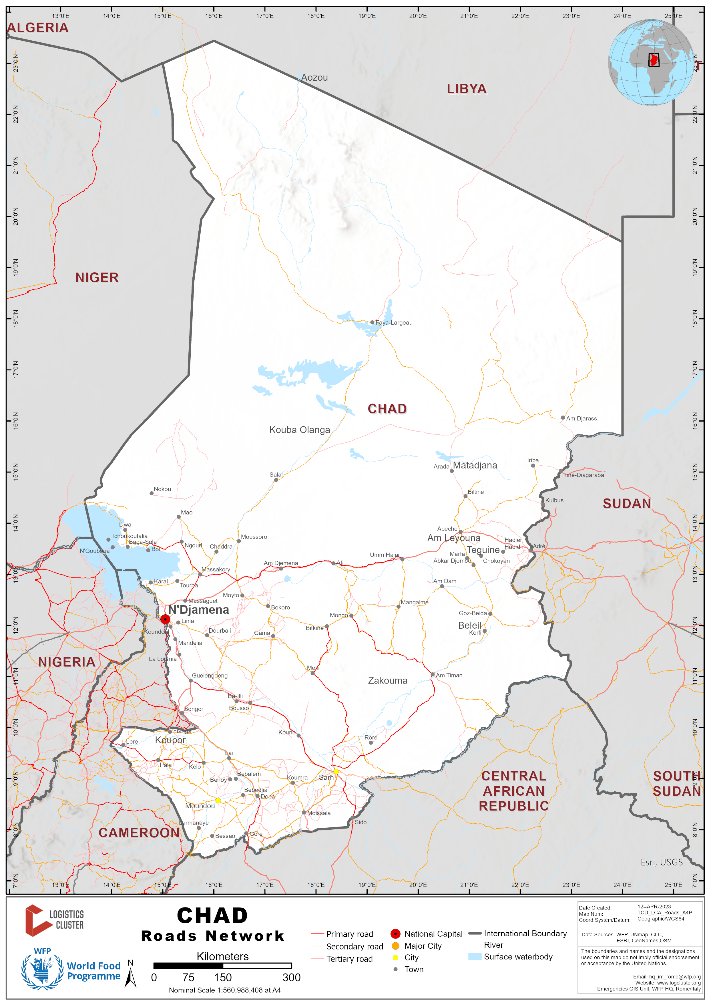
There is a considerable amount of roadway in Chad. As of 2018, there was 40,000 Km of road with roughly 206 Km of paved urban road. Of the 40,000 Km of road, 62.5% (25,000 Km) are national and regional roads while 37.5% (15,000 Km) are local roads. After 2018, however, little data are available on the actual size and material infrastructure of the road network. The primary authority on the maintenance and development of the national road network is the Ministry of Public Works. Despite the size of roadway, Chad suffers from an underdeveloped road network which is poorly connected to foreign markets. Flooding, which makes many roads impassable, and regional conflicts limit Chad’s road network capacity despite its geographical location.
National Road Network
The 25,000 km of roads of national or regional interest include 6,200 km of road in the National Structural Network and 18,800 km of road in the Regional Road Network (RRR). The National Structural Network is broken down into two categories: the Permanent National Network (2,578 km) and the Seasonal National Network (3,622 km).
Sections of the National Structural Network are outlined in the table below:
|
National Structural Network |
|
|---|---|
|
Section |
Km |
|
N’Djamena to Djerdjeraba |
32.5 |
|
Djerdjeraba to Karal |
80 |
|
N’gueli to Walia to Farcha |
25 |
|
N’Djamena to Mandalia |
54 |
|
Mandalia to Kalgoa |
42 |
|
Kalgoa to Guelengdeng |
60 |
|
Guelengdeng to Bongor to Ere |
165 |
|
Ere to Kelo |
52 |
|
Kelo to Moundou |
100 |
|
Djerdjeraba to Massaguet |
46 |
|
Massaguet to N’Goura |
125 |
|
N’Goura to Bokoro |
106 |
|
Bokoro to Arboutchatak |
66 |
|
Arboutchatak to Bitkin |
77 |
|
Bitkin to Mongo |
61 |
|
Mongo to Mangalmé |
129 |
|
Mangalmé to Oum Hadjer |
115 |
|
Oum Hadjer to Abéché |
148 |
|
Massaguet to Massakory |
66 |
|
Moundou to Koutéré |
118 |
|
N’Djamena to Dourbali |
106 |
|
Moundou to Doba |
112 |
|
Doba to Koumra |
91 |
|
Koumra to Sarh |
113 |
|
Sarh to Banda to Maro to the Central African Republic border |
125 |
|
Kelo to Pala |
106 |
|
Pala to Cameroonian border |
122 |
|
Massakory to Bol |
186 |
|
Abéché to Sudanese border |
174 |
|
Abéché to Bilitine |
93 |
|
Aboudeia to Mongo |
123 |
|
Abeche to Am Zoer to Guereda to Iriba to Tiné |
295 |
|
Abeche to Goz Beida |
210 |
|
Abou Deia to Am Timan |
139 |
|
Ati to Mongo |
175 |
|
Bitkin to Melfi |
132 |
|
Binder to Léré |
134 |
|
Bongor to the Cameroon border |
7 |
|
Kélo to Gounou Gaya to Tikem |
110 |
|
Djoumane to Laï to Gabri Ngolo |
108 |
|
Gabri Ngolo to Doba |
93 |
|
Ham to Fianga |
77 |
|
Dourbali to Massenya |
59 |
|
Fianga to Pala |
74 |
|
Goz Beida to Am Timan |
215 |
|
Doba to Goré |
45 |
|
Kélo to Laï |
60 |
|
Kélo to Doher to Benoye to Moundou |
100 |
|
Koumra to Moissala |
75 |
|
Laï to Koumra |
199 |
|
Mbaikoro to Gore to Békoninga |
205 |
|
Mogo to Kouno |
320 |
|
Ngoura to Ati to Oum Hadjer |
400 |
|
Sarh to Banda |
714 |
|
Sarh to Kyabé |
101 |
|
Ngouri to Mao |
60 |
|
Aboudeia to Mangalmé |
141 |
|
Am Timan to Haraze Mangueye |
157 |
|
Kemdéré to Moïssala |
199 |
|
Massakory to Moussoro |
135 |
The 15,000 km of regional, feeder roads of local interest include two networks: rural and urban. These feeder roads are managed by local authorities with some technical and financial support from the Chadian government.
Rural Road Network
The network is typically used for the transport of agricultural products from villages to rural markets and is generally carried out by rudimentary means of transport (man, animal, cart, rickshaw, tote). More developed routes, because of constant traffic, typically have motorized transport is generally applied. Rural transport in Chad is centered around weekly markets. Rural communities are usually within 30 km of the nearest market. Traffic on rural roads is generally very low except on market days.
Distance Matrix
|
Distances from Major Towns (km) |
||||||||||||||||||
|---|---|---|---|---|---|---|---|---|---|---|---|---|---|---|---|---|---|---|
|
|
N’Djamena |
Ati |
Abeche |
Moundou |
Sarh |
Doba |
Bongor |
Faya-Largeau |
Mongo |
Mao |
Fada |
Moussoro |
Bardai |
Bol |
Goz Beida |
Massakory |
||
|
N’Djamena |
|
27 |
748 |
473 |
561 |
500 |
240 |
775 |
510 |
312 |
890 |
300 |
1059 |
330 |
951 |
144 |
||
|
Ati |
27 |
|
312 |
908 |
715 |
915 |
674 |
533 |
175 |
593 |
556 |
332 |
907 |
611 |
540 |
425 |
||
|
Abeche |
748 |
312 |
|
1219 |
929 |
1129 |
985 |
489 |
389 |
904 |
382 |
643 |
918 |
922 |
210 |
735 |
||
|
Moundou |
473 |
908 |
1219 |
|
310 |
112 |
234 |
1084 |
848 |
783 |
1119 |
771 |
1415 |
801 |
883 |
615 |
||
|
Sarh |
561 |
715 |
929 |
310 |
|
200 |
419 |
981 |
541 |
867 |
956 |
768 |
1361 |
885 |
557 |
699 |
||
|
Doba |
500 |
915 |
1129 |
112 |
200 |
|
260 |
1043 |
741 |
810 |
1079 |
798 |
1402 |
828 |
777 |
642 |
||
|
Bongor |
240 |
674 |
985 |
234 |
419 |
260 |
|
945 |
747 |
549 |
1023 |
537 |
1241 |
568 |
995 |
381 |
||
|
Faya-Largeau |
775 |
533 |
489 |
1084 |
981 |
1043 |
945 |
|
635 |
591 |
275 |
555 |
443 |
681 |
678 |
655 |
||
|
Mongo |
510 |
175 |
389 |
848 |
541 |
741 |
747 |
635 |
|
666 |
637 |
405 |
1033 |
684 |
443 |
497 |
||
|
Mao |
312 |
593 |
904 |
783 |
867 |
810 |
549 |
591 |
666 |
|
753 |
456 |
816 |
350 |
1107 |
168 |
||
|
Fada |
890 |
556 |
382 |
1119 |
956 |
1079 |
1023 |
275 |
637 |
753 |
|
669 |
668 |
844 |
559 |
783 |
||
|
Moussoro |
300 |
332 |
643 |
771 |
768 |
798 |
537 |
555 |
405 |
456 |
669 |
|
857 |
474 |
846 |
287 |
||
|
Bardai |
1059 |
907 |
918 |
1415 |
1361 |
1402 |
1241 |
443 |
1033 |
816 |
668 |
857 |
|
912 |
1111 |
933 |
||
|
Bol |
330 |
611 |
922 |
801 |
885 |
828 |
568 |
681 |
684 |
350 |
844 |
474 |
912 |
|
1125 |
186 |
||
|
Goz Beida |
951 |
540 |
210 |
883 |
577 |
777 |
995 |
678 |
443 |
1107 |
559 |
846 |
1111 |
1125 |
|
939 |
||
|
Massakory |
144 |
425 |
735 |
615 |
699 |
642 |
381 |
655 |
497 |
168 |
783 |
287 |
933 |
186 |
939 |
|
||
|
Travel Time from Major Towns by Passenger Car (hours) |
||||||||
|---|---|---|---|---|---|---|---|---|
|
|
N’Djamena |
Ati |
Abeche |
Moundou |
Sarh |
Doba |
Bongor |
Mongo |
|
N’Djamena |
|
6:30 |
10:53 |
8:02 |
10:23 |
8:39 |
4:58 |
7:37 |
|
Ati |
6:30 |
|
4:29 |
14:27 |
11:12 |
14:19 |
11:22 |
2:58 |
|
Abeche |
10:53 |
4:29 |
|
18:48 |
13:39 |
16:45 |
15:44 |
5:25 |
|
Moundou |
8:02 |
14:27 |
18:48 |
|
4:59 |
2:03 |
3:04 |
13:13 |
|
Sarh |
10:23 |
11:12 |
13:39 |
4:59 |
|
3:07 |
6:08 |
8:22 |
|
Doba |
8:39 |
14:19 |
16:45 |
2:03 |
3:07 |
|
3:41 |
11:28 |
|
Bongor |
4:58 |
11:22 |
15:44 |
3:04 |
6:08 |
3:41 |
|
12:33 |
|
Mongo |
7:37 |
2:58 |
5:25 |
13:13 |
8:22 |
11:28 |
12:33 |
|
|
Travel Time from Major Towns by Truck (hours) |
||||||||
|---|---|---|---|---|---|---|---|---|
|
|
N’Djamena |
Ati |
Abeche |
Moundou |
Sarh |
Doba |
Bongor |
Mongo |
|
N’Djamena |
|
12 |
18 |
10 |
18 |
16 |
6 |
10 |
|
Ati |
12 |
|
6 |
22 |
30 |
26 |
18 |
4 |
|
Abeche |
18 |
6 |
|
28 |
36 |
32 |
24 |
8 |
|
Moundou |
10 |
22 |
28 |
|
8 |
4 |
4 |
22 |
|
Sarh |
18 |
28 |
36 |
8 |
|
4 |
12 |
28 |
|
Doba |
16 |
26 |
28 |
4 |
4 |
|
8 |
26 |
|
Bongor |
6 |
22 |
28 |
4 |
12 |
8 |
|
18 |
|
Mongo |
10 |
4 |
8 |
20 |
30 |
26 |
18 |
|
Road Security
Roads are relatively unsafe in Chad. Car and motorbike accidents, thefts, and robberies are common. Typically, unpaved, and unlit road sections experience more accidents and crimes. Most accidents are the result of poor road conditions, speeding, or overloading of vehicles.
The severity of insecurity depends on the location. In the northern and eastern (bordering Sudan) part of Chad, military escorts are mandatory. In these regions, insurgent groups have been known to attempt kidnappings.
Weighbridges
|
Maximum Authorized Load (PTAC) |
Size of Truck |
|---|---|
|
32 Tons |
Height: 4 m Width: 2.5 m |
In case the PTAC obligations are not followed, penalties can be imposed. The penalty thresholds can be seen in the table below:
|
Overweight (> 5 tons) |
Overweight between 5 and 10 tons |
Overweight (> 10 tons) |
|---|---|---|
|
25,000 CFA/ extra ton |
50,000 CFA/ extra ton |
75,000 CFA/ extra ton |
Axle Load Limits
|
Axle Load Limits |
LCA Country (Chad) |
Transit Country #1 (Cameroon) |
|---|---|---|
|
Truck with 2 Axles |
21 tons |
21 tons |
|
Truck with 3 Axles |
32 tons |
27 tons |
|
Semi-trailer with 3 Axles |
32 tons |
27 tons |
Road Class
|
Classification |
Administering Agency |
Local Description |
|---|---|---|
|
National Roads (Asphalt) |
Ministry of Public Works |
Found in Ndjamena to 5 towns (Abeche, Massakory, Bongor, Koutere, and Sarh) |
|
National Roads (Gravel) |
Ministry of Public Works |
Found mainly in the southern part of the country between main towns |
|
Regional and Departmental Roads (levelled sand) |
Regional Authorities |
Typically, regional roads are between towns and are mostly compacted and developed from constant traffic |
|
Rural Roads (grass and sand) |
Local Authorities |
Roads with little to no infrastructure that are between villages |
Surface Conditions
The road network is comprised of asphalt, laterite, gravel, or stabilized sand with levelling occurring during the dry season. During the wet season, interior roads are often cut off by heavy rains and flooding. Throughout this period only paved roads remain passable.
Rain Barriers
Heavy rains during the wet season sometimes warrant government mandated rain barriers. By legal national decree in 2008, the Ministry of Public Works was named the rain barrier declaring authority. Civilian traffic is asked to abide by the rules and regulations of the rain barrier, however special cases can be granted by the Ministry of Public Works in the case of emergency. Passenger car restrictions typically last no longer than 2 hours. Commercial truck restrictions vary depending on a variety of factors (road frequency, condition, and overall security). Therefore, trucks can be stopped for longer periods of time.
In case of violation of the decree, the government can impose the following penalties:
-
500,000 CFA fine to be paid by the vehicle owner
-
Revocation of the driver’s license
-
Participation in the rehabilitation of the road section damaged by the vehicle
Ouadi (drifts)
In Chad, the main constraints of road transport during the rainy season are Ouadis. Essentially, Ouadis are mudslides that can reach up to 3 meters. During times of heavy rains (typically between July and October), Ouadis can make roads completely inaccessible and cause significant damages. Some of the most famous Ouadis include the Moutarare and Amdout located in the East. The table below identifies some of the most notorious Ouadis in Chad.
|
Location |
Name of Ouadi |
|---|---|
|
Bokoro |
Bang-Bang |
|
Moussoro |
Amsilep 1 and 2 |
|
Abeche to Oum Hadjer |
Disko |
|
Abeche to Oum Hadjer |
Kao |
|
Abeche to Farchana |
Chope |
|
Abeche to Farchana |
Moura |
|
Farchana to Adre |
Farcha |
Chad - 2.4 Chad Railway Assessment

Currently, railways are not available in Chad. However, plans to construct a railway connecting Cameroon and Chad are underway. On February 15, 2022, the World Bank approved US $538 million in financing from the International Development Association (IDA) for the Cameroon-Chad Transport Corridor Project to improve the road and rail infrastructure from Douala, Cameroon to the capital of Chad, N'Djamena. The project is currently active (as of 2022) and is expected to run until June 2032. The implementing agencies are the Chadian Ministry for Infrastructure, the Cameroonian Ministry of Transport, and the private company CAMRAIL.
The nearest existing railway network ends in Ngaoundéré, Cameroon. For more information about the Cameroonian railway network click here.
Chad - 2.5 Chad Waterways Assessment
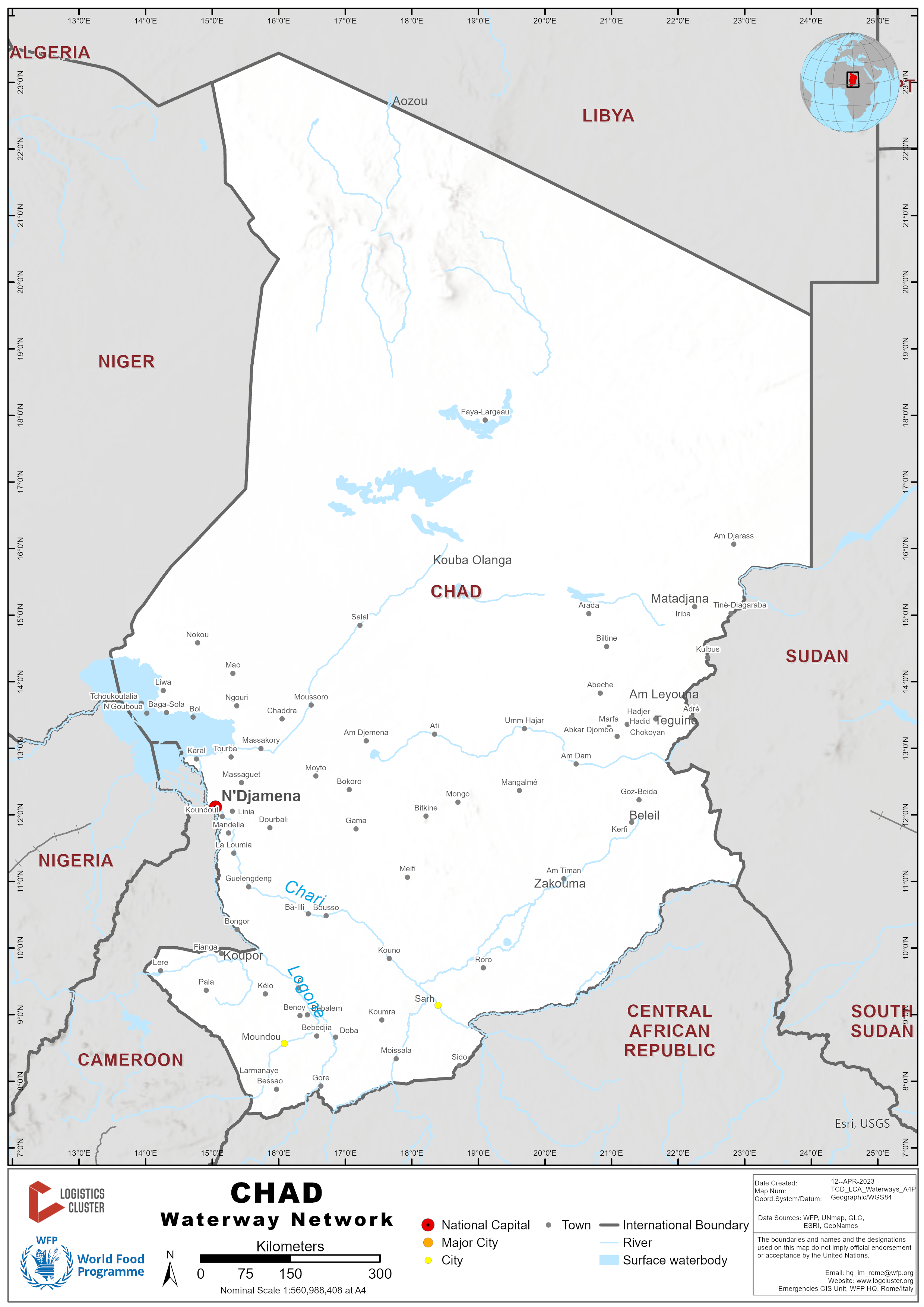

Chad’s waterways consist primarily of three main bodies of water: the Logone and Chari rivers, and Lake Chad. Despite the importance of Chadian waterways to economic activity and cross-border trade, there is no organized river and or lake transportation network. Activity on Chadian waterways is exclusively informal.
Logone and Chari Rivers
Chad's major rivers are the Chari and the Logone, which flow from the southeast into Lake Chad in the west. The river network is little developed and especially dependent on the seasons. The Chari is approximately 1,400 kilometres long and is a tributary of Lake Chad while the Logone is approximately 1,000 kilometres and is a tributary of the Chari. The Chari provides 90 percent of the water flowing into Lake Chad and the watershed of the river covers 548,747 square kilometres. Due to seasonal variations, the Logone is navigable roughly 2 months out of the year while the Chari is navigable almost permanently downstream from N'Djamena, and 4 months per year from Sarh to N'Djamena.
Other notable rivers in Chad
-
Pendé
-
Mbéré
-
Bahr Erguig
-
Bahr Salamat
-
Bahr Azoum
-
Ouadi Kadja
-
Ouham
-
Nana Barya
-
Bahr Kéita
-
Ko
-
Bragoto
-
Bahr Aouk (Aoukalé)
Lake Chad

Lake Chad is a freshwater lake located east of the African Sahel and on the southern edge of the Sahara surrounded by four different countries (Chad, Cameroon, Niger, and Nigeria). The lake is of significant economic importance to the inhabitants of the region regarding basic access to fresh water and the local fishing industry. Despite Lake Chad experiencing significant surface area variation for centuries, evidence suggests that the lake has shrunk considerably since the 1960s.

In 1963, Lake Chad was estimated to have an area of 25,000 km2. The most recent estimate (2020) approximates a surface area of 1,540 km2. Despite the uncertainty surrounding the reasons for the shrinking of the lake (over-use by governments and local communities, rainfall patterns shifting, and sea surface temperature changes), the livelihoods of those dependent on the Lake is becoming increasingly threatened. Currently, the only protected area is the Lake Chad Game Reserve, which covers half of the area next to the lake that belongs to Nigeria. Efforts by the Chadian government to protect the lake are minimal because of the potential opportunities for economic extraction. In 2020, to explore oil and mining opportunities in the region, Chad's tourism and culture minister asked UNESCO to postpone the process of registering Lake Chad on the world heritage list.
Apart from Lake Chad, there is also the Fitri, Iro, Lere, Tikem, and the two Ounianga lakes. Oases are scattered in the desert zone in the north.
Waterway Transport
Most transport activities are provided by canoes (manual or motorized) of fifteen to twenty meters long and a maximum load of about 40 tons. Navigation conditions are difficult, and costs can be high due to constant obstruction of waterways. The “Union des transporteurs fluviaux” based in Bol and Bagasola has a fleet of boats and are willing to complete trips throughout the Lac region. The loading bay is in Guite and depending on the season and the type of boat, the cargo could reach Bol and/or Bagasola within one to two days. See section 4.3 Chad Port and Waterways Company Contact List for more details.
Security
Riverways
Despite widespread informality on the management and maintenance of the river system in Chad, a river security post between Cameroon and Chad exists. Policemen from both countries are tasked with controlling the eight security posts along the fluvial border from Bongor in the south through Ndjamena to Lake Chad.
Lake Chad Basin
The Lake Chad Basin grapples with various security threats ranging from banditry, abduction, and robbery to terrorism, and food insecurity. The militant organization Boko Haram is quite active in the region limiting the ability of the government to build state capacity and humanitarian organizations to reach vulnerable populations in need.
Chad - 2.6 Chad Storage Assessment

In Chad, there is sufficient access to storage facilities around the country for public, commercial, and humanitarian uses. However, storage facilities that are in good working condition, equipped with amenities (like lighting and cold storage), and are well built are not overly abundant. The facilities that are built with modern infrastructure are primarily located in urban areas (like N’djamena and Abeche) and often cost much more than basic warehouses.
For more information on storage company contact details, please see the following link: 4.8 Storage Contact List
Commercial Storage
Commercial storage facilities are most prevalent in urban areas and often have amenities like office facilities, electricity, water access, and hired security. Commercial storage facilities are generally more expensive than humanitarian and public sector storage.
|
Location |
GPS Coordinates |
Owner |
Available for Rent? (As of Q1 2022) |
Capacity (MT / m² / m³) |
Type* |
Access** |
Condition*** |
|---|---|---|---|---|---|---|---|
|
Abeche
|
13.8282613 20.8617046 |
Youssoouf Hamad |
No |
328 MT 210 m² 840 m³ |
Open Storage |
Flat |
Under construction/ repair |
|
Abeche |
13.8280554 20.8616669 |
Youssoouf Hamad |
Yes |
975 MT 624 m² 2496 m³
|
Concrete |
Raised siding |
Appears intact |
|
Abeche |
13.8260729 20.8759057 |
Youssoouf Hamad |
No |
8100 m² |
Open Storage |
Flat |
Under construction/ repair |
|
Abeche |
13.8249396 20.8091892 |
Abdel Atiff Mahamat Ecbro |
Yes |
950 MT 600 m² 2400 m³ |
Concrete |
Raised siding |
Appears intact |
|
Abeche |
13.8265745 20.8160465 |
Abdel Atiff Mahamat Ecbro |
Yes |
1450 MT 230 m² 920 m³ |
Concrete |
Raised siding |
Appears intact |
|
Abeche |
13.8280554 20.8616669 |
Youssoouf Hamad |
Yes |
975 MT 624 m² 2496 m³ |
Concrete |
Raised siding |
Appears intact |
|
Abeche |
13.8153832 20.8094448 |
Mahamat Siboro |
Yes |
850 MT 175 m² 525 m³ |
Concrete |
Raised siding |
Appears intact |
|
Abeche |
13.8314879 20.8524839 |
Entreprise Waditrone |
Yes |
600 MT 320 m² 1280 m³ |
Concrete |
Raised siding |
Appears intact |
|
Abeche |
13.8188891 20.797201 |
Renatus |
No |
3500 MT 1600 m² 6500 m³ |
Concrete |
Raised siding |
Appears intact |
|
Abeche |
13.8290603 20.8407612 |
Unlisted- informal visit |
Yes |
600 MT 385 m² 1540 m³ |
Concrete |
Raised siding |
Appears intact |
|
Abeche |
13.8291883 20.840784 |
Unlisted- informal visit |
Yes |
350 MT 210 m² 840 m³ |
Concrete |
Raised siding |
Appears intact |
|
Adre |
13.4660823 22.2091784 |
Ousmane Adam Bahar |
Yes |
350 MT 200 m² 800 m³ |
Concrete |
Raised siding |
Appears intact |
|
Adre |
13.4679208 22.2087804 |
Said Mahamoud Ali |
Yes |
60 MT 35 m² 140 m³ |
Concrete |
Raised siding |
Appears intact |
|
Adre |
13.4673976 22.2087257 |
Mahamat Nour |
Yes |
100 MT 64 m² 256 m³ |
Concrete |
Raised siding |
Appears intact |
|
Adre |
13.4672191 22.207972 |
Israël Ali |
Yes |
70 MT 40 m² 160 m³ |
Concrete |
Raised siding |
Appears intact |
|
Adre |
13.4655554 22.2067894 |
Margui |
Yes |
550 MT 150 m² 600 m³ |
Concrete |
Flat |
Appears intact |
|
Adre |
13.475881 22.1845353 |
Ismael Ali |
Yes |
160 MT 100 m² 400 m³ |
Concrete |
Raised siding |
Appears intact |
|
Adre |
13.4667742 22.2083294 |
Ousmane Adam Bahar |
Yes |
185 MT 120 m² 480 m³ |
Concrete |
Raised siding |
Appears intact |
|
Adre |
13.4662488 22.2092857 |
Ousmane Adam Bahar |
Yes |
510 MT 324 m² 1296 m³ |
Concrete |
Raised siding |
Appears intact |
|
Amdjarass |
16.0620063 22.8323075 |
Tebir ahmat |
Yes |
320 m² |
Concrete |
Raised siding |
Appears intact |
|
Amdjarass |
16.0676197 22.8429452 |
HBC SA |
Yes |
3000 MT 750 m² 3750 m³ |
Concrete |
Raised siding |
Appears intact |
|
Amdjarass |
16.0669266 22.8290526 |
Bakhit Zakaria |
Yes |
375 MT 240 m² 720 m³ |
Concrete |
Raised siding |
Appears intact |
|
Bongor |
10.282938 15.3636656 |
Unlisted- Informal Visit |
Yes |
Unidentifed |
Concrete |
Raised siding |
Appears intact |
|
Haraze |
9.9483759 20.9111073 |
Omar Souleymane Babourou |
Yes |
50 m² |
Concrete |
Raised siding |
Under construction/ repair |
|
Haraze |
9.9496517 20.9100455 |
Omar Souleymane Babourou |
Yes |
56 m² |
Concrete |
Raised siding |
Appears intact |
|
Kyabe |
9.4638529 18.968689 |
Diabo Harou |
Yes |
160 m² |
Concrete |
Flat |
Appears intact |
|
Lere |
9.6485763 14.1930857 |
OPLO- Zoumnone Josue |
Yes |
70 m² 210 m³ |
Concrete |
Raised siding |
Appears intact |
|
Mao |
14.1267017 15.311189 |
CGECBT- Hamid Brahim Mahamat |
Yes |
Unverified |
Concrete |
Raised siding |
Appears intact |
|
N’Djamena |
12.142049 15.019446 |
Moussa Abdallah |
Yes (1 of 4 warehouse spaces available) |
25,920 MT 9,458 m² |
Concrete |
Raised siding |
Appears intact |
|
N’Djamena |
12.12616480 14.99893908 |
Adam Yunus |
Yes |
18,690 MT 12,500 m² |
Concrete |
Flat |
Under construction/ repair |
|
Ngabgoto |
9.229989 18.473264 |
ESPOIR (NGO) |
Yes |
60 m² |
Concrete |
Raised siding |
Appears intact |
|
Pala |
9.3626087 14.9025358 |
AFAP- Neyom Toukoua DJABA |
Yes |
90 m² |
Concrete |
Raised siding |
Appears intact |
Storage Used by Humanitarian Organizations

Humanitarian Organizations typically own and operate warehouses themselves. Private storage service providers are limited in Chad. However, the Chadian government does allow some organizations to use their storage facilities at a low rate or even free of charge. The World Food Program (WFP) has the largest amount of storage capacity in Chad because of the need to preposition and deliver in-kind commodities to beneficiaries throughout the country. Other organizations with notable storage capacity (other than direct distribution centers) include UNICEF and AIRD.
|
Location |
Organization |
Sharing Possibility
|
Capacity (MT / m² / m³) |
Type* |
Access** |
Condition*** |
|---|---|---|---|---|---|---|
|
Guereda |
AIRD |
No |
500 MT 320 m² |
Concrete |
Raised Flooring |
Appears Intact |
|
Haraze |
AIRD |
Yes |
320 m² |
Rub-hall |
Raised Flooring |
Appears Intact |
|
Ourcassoni |
Hias |
Yes |
250 MT 160 m² 480 m³ |
Concrete |
Flat |
Appears Intact |
|
Ourcassoni |
Hias |
Yes |
250 MT 160 m² 480 m³ |
Concrete |
Flat |
Appears Intact |
|
Farchana |
UNHCR |
Yes |
2,500 MT 1,530 m² 4,590 m³ |
Concrete |
Raised Flooring |
Appears Intact |
|
Abeche |
UNICEF |
No |
500 MT 320 m² 960 m³ |
Rub-hall |
Raised Flooring |
Appears Intact |
|
Abeche |
WFP |
Yes |
12,500 MT 1,000 m² 4,000 m³ |
Concrete |
Raised Flooring |
Appears Intact |
|
Abeche |
WFP |
Yes |
12,500 MT 1,000 m² 5,000 m³ |
Concrete |
Raised Flooring |
Appears Intact |
|
Abeche |
WFP |
Yes |
500 MT 320 m² 960 m³ |
Rub-hall |
Raised Flooring |
Appears Intact |
|
Abeche |
WFP |
Yes |
500 MT 320 m² 960 m³ |
Rub-hall |
Raised Flooring |
Appears Intact |
|
Abeche |
WFP |
Yes |
350 MT 240 m² 720 m³ |
Rub-hall |
Flat |
Appears Damaged |
|
Abeche |
WFP |
Yes |
5 MT 21 m² 52 m³ |
Container |
Flat |
Appears Intact |
|
Abeche |
WFP |
Yes |
6,000 MT 3,840 m² 11,520 m³ |
Rub-hall |
Flat |
Appears Intact |
|
Amnaback |
WFP |
Yes |
1,850 MT 1,200 m² 3,600 m³ |
Rub-hall |
Raised Flooring |
Appears Intact |
|
Farchana |
WFP |
Yes |
2,125 MT 1,360 m² 4,080 m³ |
Rub-hall |
Raised Flooring |
Appears Intact |
|
Guereda/ Mille |
WFP |
Yes |
2,050 MT 4,080 m² 1,360 m³ |
Rub-hall |
Raised Flooring |
Appears Intact |
|
Iridimi |
WFP |
Yes |
1,050 MT 720 m² 2,160 m³ |
Rub-hall |
Raised Flooring |
Appears Damaged |
|
Iridimi |
WFP |
Yes |
1,000 MT 640 m² 1,920 m³ |
Rub-hall |
Raised Flooring |
Appears Intact |
|
Kounoungou |
WFP |
Yes |
1,850 MT 1,200 m² 3,600 m³ |
Rub-hall |
Raised Flooring |
Appears Intact |
|
Mao |
WFP |
Yes |
2,500 MT 1,000 m² 4,000 m³ |
Concrete |
Raised Flooring |
Appears Intact |
|
Mao |
WFP |
Yes |
400 MT 440 m² 1,760 m³ |
Concrete |
Raised Flooring |
Appears Intact |
|
Mao |
WFP |
Yes |
440 MT 280 m² 840 m³ |
Rub-hall |
Raised Flooring |
Appears Intact |
|
Mao |
WFP |
Yes |
350 MT 240 m² 720 m³ |
Rub-hall |
Raised Flooring |
Appears Intact |
|
Mao |
WFP |
Yes |
500 MT 320 m² 960 m³ |
Rub-hall |
Raised Flooring |
Appears Intact |
|
Ourecassoni |
WFP |
Yes |
2,500 MT 1,600 m² 4,800 m³ |
Rub-hall |
Flat |
Appears Damaged |
|
Touloum |
WFP |
Yes |
2,050 MT 1,360 m² 4,080 m³ |
Rub-hall |
Raised Flooring |
Appears Damaged |
Public Sector Storage

In Chad, the National Agency for Rural Development Support (ANADER) and the National Food Security Office (ONASA) are the primary bodies which have adequate storage capacity. Often, ANADER and ONASA enable local humanitarian actors to store in-kind commodities in their warehouses at no/low cost. For more information on agency contacts, please see 4.1 Government Contact List.
|
Location |
Ministry / Agency |
Use Possibility |
Capacity (MT / m² / m³) |
Type* |
Access** |
Condition*** |
|---|---|---|---|---|---|---|
|
Bongor |
ANADER |
Yes |
300 MT 184 m² 552 m³ |
Concrete |
Raised Flooring |
Appears Intact |
|
Bongor |
ANADER |
Yes |
850 MT 525 m² 1,575 m³ |
Concrete |
Raised Flooring |
Appears Intact |
|
Pala |
ANADER |
Yes |
1,000 MT 432 m² 1,728 m³ |
Concrete |
Raised Flooring |
Appears Intact |
|
Kyabe |
ANADER |
Yes |
250 MT 162 m² 486 m³ |
Concrete |
Raised Flooring |
Appears Damaged |
|
Lere |
ANADER |
Yes |
120 m²
|
Concrete |
Raised Flooring |
Appears Intact |
|
Adre |
Douane |
No |
1,100 MT 660 m² 2,640 m³ |
Concrete |
Raised Flooring |
Appears Intact |
|
Abeche |
ONASA |
Yes |
1,500 MT 800 m² 4,000 m³ |
Concrete |
Raised Flooring |
Appears Intact |
|
Abeche |
ONASA |
Yes |
800 MT 600 m² 2,400m³ |
Concrete |
Raised Flooring |
Appears Intact |
|
Iriba |
ONASA |
Yes |
2,000 MT 525 m² 2,100 m³ |
Concrete |
Raised Flooring |
Appears Intact |
|
Bahai |
ONASA |
Yes |
200 MT 128 m² 384 m³ |
Concrete |
Raised Flooring |
Appears Intact |
|
Rig Rig |
ONASA |
Yes |
110 MT 70 m² 210 m³ |
Concrete |
Flat |
Appears Intact |
|
Nokou |
ONASA |
Yes |
2,500 MT 855 m² 3,420 m³ |
Concrete |
Raised Flooring |
Appears Intact |
|
Amdjarass |
ONASA |
Yes |
Unavailable |
Concrete |
Raised Flooring |
Appears Intact |
|
Mao |
ONASA |
Yes |
1,500 MT 525 m² 2,100 m³ |
Concrete |
Raised Flooring |
Appears Intact |
|
Bongor |
ONASA |
Yes |
1,000 MT 360 m² 3,000 m³ |
Concrete |
Raised Flooring |
Appears Intact |
|
Pala |
ONASA |
Yes |
1,500 MT 336 m² 2,688 m³ |
Concrete |
Raised Flooring |
Appears Intact |
|
Kyabe |
ONASA |
Yes |
1,500 MT 525 m² 4,200 m³ |
Concrete |
Raised Flooring |
Appears Intact |
|
Sarh |
ONASA |
Yes |
525 m²
|
Concrete |
Raised Flooring |
Appears Intact |
|
Amti man |
ONASA |
Yes |
800 m² 4,800 m³ |
Concrete |
Raised Flooring |
Appears Intact |
Cold Chain

Cold chain options are limited in Chad. Aside from vaccine storage options provided by Chad’s Ministry of Health, little cold chain infrastructure exists. The information on Cold chain storage capacity presented below, except for information on IRC’s cold chain system, was collected in 2018.
|
Location |
Organization / Owner |
Type**** |
Cooling / Power***** |
Quantity |
Total Capacity (m³) |
Condition*** |
|---|---|---|---|---|---|---|
|
Abeche |
Ministry of Health |
Cold Room Negative |
Generator |
1 |
14 |
Appears Intact |
|
Abeche |
Ministry of Health |
Cold Room Positive |
Generator |
1 |
24 |
Appears Intact |
|
Moundou |
Ministry of Health |
Cold Room Negative |
Generator/ City Power |
1 |
9 |
Under Construction/ Repair |
|
Moundou |
Ministry of Health |
Cold Room Positive |
Generator/ City Power |
1 |
12 |
Under Construction/ Repair |
|
N’Djamena |
Ministry of Health |
Cold Room Positive |
Generator/ City Power |
5 |
200 |
Appears Intact |
|
N’Djamena |
Ministry of Health |
Cold Room Negative |
Generator/ City Power |
1 |
20 |
Appears Intact |
|
N’Djamena |
Ministry of Health |
Cold Room Positive |
Generator/ City Power |
1 |
20 |
Appears Intact |
|
N’Djamena |
Ministry of Health |
Cold Room Negative |
Generator/ City Power |
2 |
20 |
Appears Intact |
|
Sahr |
Ministry of Health |
Cold Room Positive |
Generator/ City Power |
1 |
40 |
Appears Intact |
|
Sahr |
Ministry of Health |
Cold Room Negative |
Generator/ City Power |
1 |
20 |
Appears Intact |
|
Mile |
IRC |
Freezer |
Solar |
1 |
Unknown |
Appears Intact |
|
Moundou |
UNICEF |
Cold Room Positive |
Generator/ City Power |
1 |
150 |
Under Construction/ Repair |
*Warehouse Type: Open storage, container, rub-hall, silo, concrete, other, unspecified
**Warehouse Access: Raised-siding, flat
*** Warehouse Condition: Appears intact, appears damaged, under construction/repair
****Cold Room Type: Cold Room Positive, Cold Room Negative, Refrigerator, Freezer
*****Cold Room Cooling/Power: Compression, Absorption, Solar, Other, unspecified
Chad - 2.7 Chad Milling Assessment
Milling capacity within Chad is extremely limited. The milling facilities that do exist are for small and local production. Milling machines are not produced locally with supply coming from Ghana and Burkina Faso primarily. The mills mentioned below are two examples of the type of milling capacity that currently exists in Chad. Despite being heavily reliant on agricultural production for income generation, medium-sized to large scale mills are not operational in rural or urban (including the capital N’Djamena) areas. Limited milling capacity needs to be taken into consideration while planning commercial and humanitarian operations.
Milling Company Association des femmes pour l’autopromotion (AFAP)

|
Company Name and Location |
Contact |
Telephone |
|---|---|---|
|
AFAP Pala GPS Coordinates: 9.3627308 14.9021759 |
Email: neyom59@gmail.com
|
Tel: +235 62363394 +235 93628767
|
|
Summary of Role and Services |
||
|
AFAP uses their milling equipment to manufacture enriched flour for children from 0 to 24 months old. The group originated from a collaboration between the NGO Experts-Solidaires and 7 groups of women farmers (200 women in total) in Pala in the Southwest of Chad. The activities planned in this project included training in agro-food processing, assistance in acquiring equipment, support to the 7 groups for the management and marketing of products, as well as a social component to limit violence against women. See the link here for more details. |
||
|
Facilities |
|
|---|---|
|
Parking Area Inside Compound (m²) |
N/A |
|
Drainage |
Non-Existent |
|
Fire Fighting Equipment |
No |
|
Number of Ventilators (screened) |
3 |
|
Electricity Load (KVA) |
50 |
|
Backup Generator(s) |
No |
|
Milling Equipment |
|||
|---|---|---|---|
|
Origin of Machinery |
Year of Manufacturing |
Year of Installation |
Condition |
|
Ghana and Burkina Faso |
2018 |
2019 |
Passable |
|
Maintenance |
|||
|---|---|---|---|
|
Duration |
250 hours |
Type of Maintenance |
Preventative |
|
Other Equipment or Machinery Installed |
|
|---|---|
|
Type of Equipment |
Available |
|
Fortification Feeder |
No |
|
Bag Cleaning Plant |
No |
|
Moisture Tester |
No |
|
De-stoning Plant |
No |
|
Metal Extractor |
No |
|
Staffing |
|
|---|---|
|
Number of Full Time Skilled Workers |
14 |
|
Number of Full Time Labourers |
35 |
|
Weigh scales |
||
|---|---|---|
|
Number |
5 |
Capacity (MT) |
|
Within Compound |
.15 |
|
|
Building |
|
|---|---|
|
Walls |
Mesh fence and cement acting as a closure |
|
Roof |
Sheet metal |
|
Floor |
Cement flooring |
|
Conditions & Cleanliness |
||
|---|---|---|
|
|
Outside |
Inside |
|
Cracks in Walls or Roof |
No |
No |
|
Signs of Rodent Activity |
No |
No |
|
Signs of Birds Entry |
Yes |
No |
|
Damaged Gutters/Drains |
N/A |
N/A |
|
Signs of Moisture |
Yes |
No |
|
Adjacent Vegetation |
No |
No |
|
Cleanliness |
Good |
Good |
|
Pest Control |
|||||
|---|---|---|---|---|---|
|
Fumigation |
No |
Frequency |
N/A |
Contracted |
N/A |
|
Spraying |
No |
Frequency |
N/A |
Contracted |
N/A |
|
Rodenticides |
No |
Frequency |
N/A |
Contracted |
N/A |
|
Rodent Trapping |
Yes |
Frequency |
Weekly |
Contracted |
No |
|
Security |
|
|---|---|
|
Security |
Good |
|
Compound |
Fenced |
|
Access |
|
|---|---|
|
Distance from Main Town (km) |
Located in Pala (189 km by road from Moundou and 433 km by road from Ndjamena) |
|
Travel Time if not Located in Town (hours) |
(3 hours from Moundou and 8 hours from Ndjamena) |
|
Road Condition to Mill |
Passable |
|
Road Limitations (if any) |
N/A |
|
Rail Connections |
No |
|
Milling Capacity |
|
|---|---|
|
Commodities |
Daily Capacity (Kg) |
|
Maize |
270 |
|
Groundnuts |
35 |
|
Soybean |
40 |
|
Black-eyed Peas |
40 |
|
Loading & Discharge Rates |
|---|
|
100 XAF (17¢) per unit |
|
Additional Notes |
|---|
|
On average, AFAP does 10 bags of corn per day with the mill. |
Milling Company Pro Fort

|
Company Name and Location |
Contact |
Telephone |
|---|---|---|
|
Pro Fort GPS Coordinates: 9.64868 14.1931685 |
Email: oplolere@gmail.com |
Tel: +235 66371603 +235 93063761
|
|
Summary of Role and Services |
||
|
The mill produces flour for children who are suffering from malnutrition. |
||
|
Facilities |
|
|---|---|
|
Parking Area Inside Compound (m²) |
2000 |
|
Drainage |
Good |
|
Fire Fighting Equipment |
Yes |
|
Number of Ventilators (screened) |
8 |
|
Electricity Load (KVA) |
45 |
|
Backup Generator(s) |
Yes
|
|
Milling Equipment |
|||
|---|---|---|---|
|
Origin of Machinery |
Year of Manufacturing |
Year of Installation |
Condition |
|
Ghana and Burkina Faso |
2018 |
2018 |
Project with four partners (WFP, WHO, UNICEF, FAO) who help with general upkeep of equipment |
|
Maintenance |
|||
|---|---|---|---|
|
Duration |
Monthly |
Type of Maintenance |
Preventative |
|
Other Equipment or Machinery Installed |
||||
|---|---|---|---|---|
|
Type of Equipment |
Available |
Number |
Owned |
Comments |
|
Fortification Feeder |
Yes |
1 |
1 |
None |
|
Bag Cleaning Plant |
No |
N/A |
N/A |
N/A |
|
Moisture Tester |
No |
N/A |
N/A |
N/A |
|
De-stoning Plant |
No |
N/A |
N/A |
N/A |
|
Metal Extractor |
No |
N/A |
N/A |
N/A |
|
Staffing |
|
|---|---|
|
Number of Full Time Skilled Workers |
5 |
|
Number of Full Time Labourers |
2 |
|
Weigh scales |
||
|---|---|---|
|
Number: 4 |
Capacity (MT) |
|
|
Within Compound |
|
.3 |
|
Building |
|||
|---|---|---|---|
|
|
Length (m) |
Width (m) |
Height (m) |
|
Building – Maize Mill |
12 |
8 |
4 |
|
Walls |
Cement and boards |
||
|
Roof |
Sheet Metal |
||
|
Floor |
Cement |
||
|
Conditions & Cleanliness |
||
|---|---|---|
|
|
Outside |
Inside |
|
Cracks in Walls or Roof |
No |
No |
|
Signs of Rodent Activity |
Yes |
No |
|
Signs of Birds Entry |
Yes |
No |
|
Damaged Gutters/Drains |
No |
No |
|
Signs of Moisture |
No |
No |
|
Adjacent Vegetation |
No |
No |
|
Cleanliness |
Good |
Good |
|
Pest Control |
|||||
|---|---|---|---|---|---|
|
Fumigation |
No |
Frequency |
N/A |
Contracted |
N/A |
|
Spraying |
No |
Frequency |
N/A |
Contracted |
N/A |
|
Rodenticides |
No |
Frequency |
N/A |
Contracted |
N/A |
|
Rodent Trapping |
Yes |
Frequency |
Weekly |
Contracted |
No |
|
Security |
|
|---|---|
|
Security |
Good |
|
Compound |
Fenced |
|
Access |
|
|---|---|
|
Distance from Main Town (km) |
Located in Lere (530 km from N’djamena) |
|
Travel Time if not Located in Town (hours) |
10.5 hours to N’djamena |
|
Road Condition to Mill |
Passable |
|
Road Limitations (if any) |
N/A |
|
Rail Connections |
No |
|
Milling Capacity |
|
|---|---|
|
Commodities |
Daily Capacity (Kg) |
|
Maize |
300 |
|
Groundnuts |
5 |
|
Soybean |
72 |
|
Black-eyed Peas |
60 |
|
Loading & Discharge Rates |
|---|
|
100 XAF (17¢) per unit |
|
Transport Capacity at Mill |
|---|
|
800 Kg |