Mozambique - 2 Mozambique Logistics Infrastructure
Mozambique is a long but fairly narrow country, with an area of 801,537 km2 that stretches over 2,500 km of coastline and 4,500 km of land borders with Tanzania, Malawi, Zambia, Zimbabwe, South Africa and Swaziland. The logistics infrastructure was designed to provide adequate gateways for the hinterland traffic through an integrated ports and railways system. The road network was conceived as a feeder system around the main urban areas, and locomotion north-south was to be made by sea for goods, and by air for the people.
Mozambique's logistical infrastructure has undergone significant development over the past decade, but still faces several challenges in terms of road network, railway, aviation, ports, waterways, and storage.
Road Network:
Mozambique's road network is extensive but in poor condition, with only a small portion of it paved. The road network is gradually being improved, mostly with donor funding, and concessions are being made on specific routes that charge tolls.
The completion of the Maputo-Katembe Bridge in 2018, which connects Maputo to the Katembe district, has enhanced access to the southern region of the country. Additionally, the rehabilitation of the N6 road from Beira to Machipanda and the asphalting of the N11 road from Mocuba to Milange were completed in 2019, further improving access to Zimbabwe and Malawi, respectively.
There are several national development and investment programs underway or planned in Mozambique to improve the road network. One of the major initiatives is the "Mozambique Safer Roads for Socio-Economic Integration Program" project, which is being implemented by the World Bank. A total of 508 kilometers of selected priority road sections of EN1 will benefit from rehabilitation. The section of EN1 in worst condition is about 1,050 km long, out of a total length of 2,600 km. The project will last 10 years, with two years of construction and eight years of maintenance. In phase 1, the intervention will focus on 508 km. This includes the stretches Inchope-Gorongosa (Sofala), Chimuara-Nicoadala (Zambézia) and Metoro-Pemba (Cabo Delgado). After finishing phase 1, phase 2 will immediately follow, which includes the Lúrio river-Metoro section (Cabo Delgado); the stretch from the Save river to Muchungwè and Muchungwe to Inchope (both in Sofala). Phase 3, includes the Pambara to Save river section (Inhambane). Over the next ten years, the World Bank will inject about 850 million dollars to finance the rehabilitation of the 1,050 kilometer stretch of the N1.
Railway:
Mozambique's national railway network spans over 3,000 km and is managed by the state-owned Mozambique Ports and Railways (CFM) company, and by Nacala Logistics, managing the northern corridor.
The railway network has no north-south connections, unless one travels through neighbouring countries. The Mozambique railway system was developed in order to be connected with the three main ports of Maputo, Beira and Nacala, mainly to provide a transportation service for exports from South Africa, Zimbabwe, Zambia and Malawi, and for some national traffic from landlocked provinces.
There has been an extensive infrastructure rehabilitation and locomotive and rolling stock renewal across all Southern and Central networks which resulted in higher tonnage capacity and reduced travel time.
The Dona Ana - Vila Nova da Fronteira Railway Line (branch of Sena line) had been rehabilitated in 2022, over a length of 44 km, awaiting the Malawian counterpart, whose works are currently in the mobilization of material and earthworks phase. The operation of this Line will allow the circulation of commercial cargo and passenger trains from the Port of Beira to Malawi.
The acquisition of additional five locomotives, 90 carriages, and 350 wagons will align with the Mozambique government's government’s 2020-2024 five-year program.
Aviation:
Currently, the aviation sector in Mozambique is relatively small, with only a few airlines operating within the country. The national carrier, LAM Mozambique Airlines, is the largest airline in the country and provides both domestic and international services. Other airlines that operate in Mozambique include TAP Portugal, Turkish Airlines, TAAG, Qatar Airways, Ethiopian Airlines, South African Airways, South African Airlink, and Kenya Airways. The country also has a number of small regional airlines that provide services to remote areas.
The government has identified the development of the aviation industry as a priority, and plans to invest in new airport infrastructure, training programs for aviation professionals, and the promotion of Mozambique as a tourist destination.
Ports:
Mozambique is a country with a long coastline of approximately 2,500 km, providing access to the Indian Ocean, extending from South Africa in the south to Tanzania in the north. The country has several major ports along its extensive coastline, including the ports of Maputo, Beira, and Nacala, which serve as critical gateways for international trade and neighbouring countries. Other smaller ports, such as Quelimane and Pemba, serve mostly nearby businesses and communities.
In 2022 a total of 1058 m of berthing area was rehabilitated in Port of Maputo, expanded and dredged to depths of up to 16 meters. Some of the planned investments are: creation of a food terminal (grains, sugar, vegetable oils, molasses); expansion of the container terminal; expansion of the intermodal container terminal (MICD); expanding TCM (Matola Coal Terminal) capacity to 12 MTPA.
Port of Beira has also benefited of some investments by Cornelder. The Container terminal benefitted from an investment to increase the capacity of its container storage space to an area of three hectares, as well as the building of a new five lane access road, with the option to add a further two lanes in the future. There has been investment in equipment such as in terminal tractors, Reachstackers, RoRo tugmasters, forklifts, weighbridges. With the projection expansion of storage yard, in addition to using Rubber Tyred Gantry Cranes (RTG´s) the port will be able to handle 700,000.00 TEU.
The northern Mozambican Port of Nacala plans to increase its cargo handling capacity from 100,000 TEU yearly to 252,000 TEU, a growth of over 150 percent, after the conclusion of the rehabilitation, expansion and modernisation works. The work is expected to be concluded in 2023 and includes the complete rehabilitation of the port facilities, dredging, construction of access roads, and investing in equipment. The rehabilitation, expansion, and modernization works were financed by the Japanese Development Agency (JICA), which disbursed 277.5 million dollars.
Rehabilitation of infrastructure on the pier and container terminal took place in Port of Quelimane, as well as dredging the access channel. This rehabilitation allowed for the expansion of the handling capacity of the container and general cargo terminal, allowing the manoeuvring basin, with a width of 200 m, to reach a depth of five meters, against the previous two to three meters.
In 2019, the Port of Pemba underwent significant rehabilitation and was equipped with modern equipment to handle various types of cargo, including Graphite, Marble, Cotton, Timber, and Clinker. The port is now capable of operating 24/7 and handling up to 27,000 TEUs annually, an increase from the previous 18,000 TEUs. CFM's investment of USD 5 million is expected to improve the flow of goods from the Port of Pemba, reducing the need to travel 400 km to the Port of Nacala, which causes damage to roads and wastes time and resources.
Waterways:
Mozambique's internal waterways have historically been an important means of transport for goods and people, but their utilization has been limited in recent years. The country has a vast network of internal waterways, including the Zambezi, Pungwe, and Save rivers, which span a total of 3,750 km However, due to a lack of investment in infrastructure and equipment, as well as the presence of natural obstacles such as sandbars and rapids, the waterways are not fully utilized.
Internal maritime transport of goods between ports was relaunched in 2020. However, cabotage has proved to be unsustainable in the national market. The revitalization of cabotage is a government initiative included in the government’s 2020-2024 five-year program, with the aim of reducing the costs of transporting goods, with an impact on prices for the final consumer.
Storage:
Mozambique is divided into ten provinces, each with its own unique storage needs and challenges. In general, the storage infrastructure in Mozambique is limited, with many areas lacking sufficient storage capacity for their needs. Reliable storage facilities are often difficult to locate, particularly in rural areas.
In the southern province of Maputo, storage facilities are primarily located in the capital city of Maputo. The city is home to several modern storage facilities, including large warehouses and cold storage facilities. However, the demand for storage in Maputo is high, and many businesses struggle to find affordable storage solutions.
In the central province of Sofala, storage facilities are more limited. The port city of Beira is the primary gateway for imports and exports in the region, but the city's storage facilities are often overwhelmed by the volume of cargo passing through the port.
In the northern province of Cabo Delgado, storage facilities are even more limited. The region has a growing natural gas industry, which requires significant storage capacity for equipment and supplies.
2.2 Mozambique Aviation

Key airport information may be found at:
Civil aviation is a critical component to the Mozambique transport system due to its immense size: the country spans over 2,300 km from North to South and the poor road network renders land transportation too slow.
The Civil Aviation Institute of Mozambique (IACM – http://www.iacm.gov.mz/) is the oversight body for all aviation activities.
The national carrier, Mozambique Airlines (LAM – http://www.lam.co.mz/), covers only national destinations and some neighbouring countries, e.g. South Africa, Tanzania, Kenya, and Zimbabwe. Several international airlines such as SAA, Kenya Airways, Ethiopian Airlines, TAAG, Qatar Airways, TAP, and Turkish Airlines have flights to Mozambique. The domestic flights are now being opened to other airlines in addition to LAM, and FastJet (https://www.fastjet.com/en) already operates to Beira, Tete and Nampula.
For more information on government agency and airport company contact information, please see the following links: 4.1 Government Contact List and 4.4 Airport Companies Contact List
Procedures for Foreign Registered Aircraft
The following steps are required before prepositioning of foreign registered aircraft:
- Application for provisional Air Service Licence by the operator contracted to provide the services. If the operator is not familiar with Mozambique, it is advisable to use a point of contact, e.g. WFP Maputo and/or a local aviation consultancy company to facilitate the process.
- UNHAS requires foreign operators to ensure that the Civil Aviation Authorities of the country of registration of the aircraft clearly takes responsibility for all safe oversight while operating in Mozambique.
- The following operator, aircraft and crew documentation is
required:
- Air Operator Certificate and crew licences
- Certificates of Registration, Airworthiness, Insurance, and Maintenance Release
- For non-scheduled and private flights, permission for over-flights and landings are required 24 hours in advance to IACM.
- Regarding over-flights, the following information is required
in item 18 of the flight plan for:
- Registration of aircraft (if different from the call sign), number of crew and passengers
- Colour and nationality of aircraft, purpose of flight, complete
post and telegraphic address of operator
- Regarding landings, the following information is required in
item 18 of the flight plan for:
- Registration of aircraft (if different from the call sign), names and nationality of crew members and/or passengers
- Names and address of entities to be contacted, nature of cargo, purpose of flight, airport of entry
- Colour and nationality of aircraft, complete postal and telegraphic address of operator.
- Upon submission of the application and documentation to IACM it will take 7 to 10 days to obtain clearance.
In addition to the above, it is essential that the Ministry of Foreign Affairs and Cooperation issues an official communication, notifying relevant Government departments and authorities of the mandate of the humanitarian organisation to respond to the emergency activity, in order to facilitate the decision-making process of the aviation regulatory bodies.
2.2.1 Mozambique Maputo International Airport
Airport Overview
Maputo airport is located three kilometres north of Maputo city.
It has a “4” aerodrome reference code and is capable of sustaining aeroplanes with a letter code up to “E”. The ATC approach is Cat I.
There are two terminals (Domestic and International) with three air bridges each and one cargo terminal.
Two handling companies and one catering company provide respective services to airlines.
The airport is open for operations 24 hours per day. However, it closes 30 minutes before and after VIP flight arrival or departure.
Maputo International Airport website:
https://www.aeroportos.co.mz/aeroporto-de-maputo
|
Maputo Airport |
|
|---|---|
|
Country |
Mozambique |
|
Province or District |
Maputo |
|
Nearest Town or City with Distance from Airport |
Maputo, 3 km |
|
Airport’s Complete Name |
Maputo International Airport or Mavalane International Airport |
|
Latitude |
-25.92086 |
|
Longitude |
32.57254 |
|
Elevation (ft and m) |
45 m (147 FT) |
|
IATA Code |
MPM |
|
ICAO Code |
FQMA |
|
Managing Company or Airport Authority |
Aeroportos de Moçambique (ADM) |
|
Management Contact Person |
Cândida Botelho - 843109373 |
|
Open From (hours) |
00:00 Hrs |
|
Open To (hours) |
24:00 Hrs |
Airport Pictures


Description and Contacts of Key Companies
The airlines operating in Maputo include:
LAM – Mozambique Airlines (www.lam.co.mz/)
SAA – South African Airways (www.flysaa.com/)
Ethiopian Airlines (www.ethiopianairlines.com/MZ/EN/)
Qatar Airways (www.qatarairways.com/)
Turkish Airlines (www.turkishairlines.com/)
TAP – Portuguese Airlines (http://www.flytap.com/)
Kenya Airways (www.kenya-airways.com/)
TAAG – Angola Airlines (www.taag.com/)
Fastjet (www.fastjet.com/)
The main handling company is MAHS (Mozambique Airport Handling Services): http://www.mahs.co.mz/
The catering company is SMS: http://www.smscatering.co.mz/
Passenger and Cargo Performance Indicator
The terminal has a capacity of 900,000 passengers a year and can serve up to 400 arriving and departing passengers per hour.
|
Performance for 2017 |
|||
|---|---|---|---|
|
Per Year |
Per Month |
Per Day |
|
|
Total Aircraft Movements |
18,858 |
||
|
Total Passengers |
940,762 |
||
|
Total Capacity of the Airport (mt) |
|||
|
Current Activity of the Airport (mt) |
|||
|
Current use by Humanitarian Flights (UNHAS) |
No |
||
Runways
|
Runway #1 |
|
|---|---|
|
Runway Dimensions |
3,660 m x 45 m |
|
Orientation |
05/23 |
|
Surface |
Flexible/Asphalt |
|
Runway #2 |
|
|---|---|
|
Runway Dimensions |
1,700 m x 45 m |
|
Orientation |
10/28 |
|
Surface |
Flexible/Asphalt |
Airport Infrastructure Details
|
Customs |
Yes |
JET A-1 fuel |
Yes |
|---|---|---|---|
|
Immigration |
Yes |
AVGAS 100 |
Yes |
|
Terminal Building |
Yes |
Single Point Refuelling |
Yes |
|
Passenger Terminal |
Yes |
Air Starter Units |
Yes |
|
Cargo terminal |
Yes |
Ground Power (mobile) |
Yes |
|
Pax Transport to Airfield |
Yes |
Ground Handling Services |
Yes |
|
Control Tower |
Yes |
Latrine Servicing |
Yes |
|
Weather Facilities |
Yes |
Fire Fighting Category (9) |
Yes |
|
Catering Services |
Yes |
De-icing Equipment |
No |
|
Base Operating Room |
Yes |
Parking Ramp Lighting |
Yes |
|
Airport Radar |
No |
Approach & Runway Lights |
Yes |
|
NDB |
No |
VOR |
Yes |
|
ILS |
Yes |
Airport Operating Details
|
Operating Details |
|||
|---|---|---|---|
|
Maximum Sized Aircraft that can be Offloaded on Bulk Cargo |
Reference code “E” |
||
|
Maximum Sized Aircraft that can be Offloaded on Pallet |
Reference code “E” |
||
|
Total Aircraft Parking Area (m²) |
|||
|
Storage Area (m3 and mt) |
|||
|
Handling Equipment |
|||
|
Elevators / Hi Loaders |
Yes |
Max Capacity (mt) |
14 tons |
|
Max Height (m) |
B747 cabin height |
||
|
Loading Ramps |
Yes |
||
|
Other Comments |
|
||
Customs Guidance
Customs is operational 24 hours a day and has an office at airport. It normally takes 3-5 minutes for each passage in the passenger terminal. In the cargo terminal, it depends on the amount of goods to be cleared.
Storage Facilities
Arrangements for storage must be requested to MAHS 48 hours in advance.
Airfield Costs
NAVIGATION CHARGES
|
Charges |
Aircraft Weight - MTOW (kg) |
||
|---|---|---|---|
|
0 - 7,000 |
7,001 - 136,000 |
136,001 and over |
|
|
Navigation (per journey) USD - $ |
23 - 56 |
56 - 342 |
342 - 540 |
|
Landing USD - $ |
5.5 |
5.5 |
5.5 |
|
Night Landing USD - $ |
±125 |
±125 |
±125 |
|
Night Take-Off USD - $ |
|
|
|
|
Parking |
0.5/3h |
0.5/3h |
0.5/3h |
|
Handling Charges |
7.5 |
7.5 |
7.5 |
FUEL SERVICES CHARGES
|
Price per Litre USD - $ |
|
|---|---|
|
Jet A-1 |
0.34 |
|
Avgas |
CARGO TERMINAL CHARGES
|
Import Charges |
||
|---|---|---|
|
Type of Charge |
Rate USD - $ per kg |
Comments |
|
Handling Charge |
5-25 |
By operation |
|
Break Bulk Fee |
|
|
|
Diplomatic Mail |
|
|
|
Strong Room – per consignment |
|
|
|
Cold Storage Fee |
|
|
|
Delivery Outside Normal Working Hours |
|
|
|
Preparation of substitute AOA – Invoice – Receipt |
|
|
|
Storage per Day |
|
|
|
Export |
||
|
Handling Charges – Un-palletized Cargo |
|
|
|
International Air Waybill |
|
|
|
Local Air Waybill |
|
|
|
Air Way Bill Amendment - Cancellation |
|
|
|
Air Way Bill Documentation |
|
|
|
Diplomatic Mail |
|
|
|
Storage Charges per Day |
|
|
AIR-BRIDGE CHARGES
|
Weight |
First Hour (USD) |
Additional (USD) |
|---|---|---|
|
0 – 40,000 kg |
83.30 |
30/30 min or fraction |
|
40,001 – 100,000 kg |
89.25 |
40/30 min or fraction |
|
100,001 – 190,000 kg |
97.75 |
50/30 min or fraction |
|
190,000 kg and over |
110.50 |
60/30 min or fraction |
Security
The airport has modern and up-to-date security screening equipment and procedures for both departing and arriving passengers. However, the control over luggage helpers present on the arrival and departure halls leaves leaves the airport open to regular security violations as there is frequent access to these restricted areas by these workers, not all of them in possession of the required permits.
2.2.2 Mozambique Beira International Airport
Airport Overview
The airport’s aerodrome reference code is “4”. It is capable of sustaining airplanes up to letter code “E”. It has one passenger terminal for both domestic and international flights, with no air bridge. ATC approach operations Cat I.
The airport closes 30 minutes before and after VIP flight arrival or departure.
|
Airport Location and Contact |
|
|---|---|
|
Country |
Mozambique |
|
Province or District |
Sofala |
|
Nearest Town or City with Distance from Airport |
Beira, 9.5 km to city |
|
Airport’s Complete Name |
Beira International Airport |
|
Latitude |
-19.79474 |
|
Longitude |
34.91583 |
|
Elevation (ft and m) |
8 m |
|
IATA Code |
BEW |
|
ICAO Code |
FQBR |
|
Managing Company or Airport Authority |
Aeroportos de Moçambique |
|
Management Contact Person |
Domingos Rodrigues +258825728840 |
|
Open From (hours) |
00:00 HRS |
|
Open To (hours) |
24:00 HRS |
Airport Pictures


Description and Contacts of Key Companies
LAM – Mozambique Airlines (www.lam.co.mz/)
Malawi Airlines (www.malawian-airlines.com/)
Fastjet (www.fastjet.com/)
Passenger and Cargo Performance Indicator
|
Performance for 2017 |
|||
|---|---|---|---|
|
Per Year |
Per Month |
Per Day |
|
|
Total Aircraft Movements |
7,107 |
||
|
Total Passengers |
186,533 |
||
|
Total Capacity of the Airport (mt) |
|||
|
Current Activity of the Airport (mt) |
|||
|
Current use by Humanitarian Flights (UNHAS) |
No |
||
Runways
|
Runway #1 |
|
|---|---|
|
Runway Dimensions |
2.400 m x 45 m |
|
Orientation |
12/30 |
|
Surface |
Asphalt |
|
Runway #2 |
|
|---|---|
|
Runway Dimensions |
1,698 m x 30 m |
|
Orientation |
17/35 |
|
Surface |
Asphalt |
Helicopter Pad(s)
|
Helipad #1 |
|
|---|---|
|
Present |
No |
|
Largest Helicopter that can Land |
|
|
Width and Length (m) |
|
|
Surface |
|
Airport Infrastructure Details
|
Customs |
Yes |
JET A-1 fuel |
Yes |
|---|---|---|---|
|
Immigration |
Yes |
AVGAS 100 |
Yes |
|
Terminal Building |
Yes |
Single Point Refuelling |
No |
|
Passenger Terminal |
Yes |
Air Starter Units |
No |
|
Cargo terminal |
Yes |
Ground Power (mobile) |
Yes |
|
PaxTransport to Airfield |
No |
Ground Handling Services |
Yes |
|
Control Tower |
Yes |
Latrine Servicing |
Yes |
|
Weather Facilities |
Yes |
Fire Fighting Category (ICAO) |
6 |
|
Catering Services |
De-icing Equipment |
No |
|
|
Base Operating Room |
Yes |
Parking Ramp Lighting |
Yes |
|
Airport Radar |
No |
Approach & Runway Lights |
Yes |
|
NDB |
Yes |
VOR |
Yes |
|
ILS |
No |
Airport Operating Details
|
Operating Details |
|||
|---|---|---|---|
|
Maximum Sized Aircraft that can be Offloaded on Bulk Cargo |
Reference Code letter “E” |
||
|
Maximum Sized Aircraft that can be Offloaded on Pallet |
Reference Code letter “E” |
||
|
Total Aircraft Parking Area (m²) |
110,816.25 |
||
|
Storage Area (m3and mt) |
|||
|
Handling Equipment |
|||
|
Elevators / Hi Loaders |
Yes |
Max Capacity (mt) |
14 |
|
Max Height (m) |
B747 cabin |
||
|
Loading Ramps |
Yes |
||
|
Other Comments |
|
||
Airfield Costs
NAVIGATION CHARGES
|
Charges |
Aircraft Weight - MTOW (kg) |
||
|---|---|---|---|
|
0 - 7,000 |
7,001 - 136,000 |
136,001 and over |
|
|
Navigation (per journey) USD - $ |
23 - 56 |
56 - 342 |
342 - 540 |
|
Landing USD - $ |
5.5 |
5.5 |
5.5 |
|
Night Landing USD - $ |
±125 |
±125 |
±125 |
|
Night Take-Off USD - $ |
|
|
|
|
Parking |
05/3h |
0.5/3h |
0.5/3h |
|
Handling Charges |
7.5 |
7.5 |
7.5 |
FUEL SERVICES CHARGES
|
Price per Litre USD - $ |
|
|---|---|
|
Jet A-1 |
0.34 |
|
Avgas |
Mozambique - 2.2.3 Mozambique Inhambane National Airport
Airport Overview
Inhambane Airport is a small domestic airport located in the Inhambane province of Mozambique. The airport serves as a gateway to the tourist destination of Tofo. The airport is regularly used by small regional airlines and charter flights that transport tourists to and from the region. One of the main issues with Inhambane Airport is its limited infrastructure and capacity. The airport only has one runway and a small terminal building.
-
Inhambane Airport is an airport in Jangamo District, Inhambane Province, Mozambique.
-
Regular flights: Maputo-Inhambane-Vilankulo, Vilankulo-Inhambane-Maputo (four times per week)
-
Charter flights usually have departure in South Africa
-
Aircrafts like Bombardier Q400
|
Airport Location and Contact |
|
|---|---|
|
Country |
Mozambique |
|
Province or District |
Jangamo, Inhambane, Gaza |
|
Nearest Town or City |
Inhambane 3 km |
|
Airport’s Complete Name |
Aeroporto de Inhambane |
|
Latitude |
-23.5200 |
|
Longitude |
35.2500 |
|
Elevation (ft and m) |
9 m |
|
IATA Code |
INH |
|
ICAO Code |
FQIN |
|
Managing Company or Airport Authority |
Aeroportos de Moçambique |
|
Management Contact Person |
Manuel Soares (+25829320312) |
|
NGO and/or UN Presence at Airport? |
No |
Airport Picture


Runway(s)
|
Runway #1 |
|
|---|---|
|
Runway Dimensions |
1500 m x 30 m |
|
Runway Orientation |
16/34 |
|
Runway Surface |
Asphalt |
|
Runway Condition |
Good |
Airport Infrastructure Details
|
Infrastructure |
|||
|---|---|---|---|
|
Passenger / Cargo Security Screening |
Yes |
Runway Lighting |
No |
|
Refueling Capacity |
Yes |
Ground Handling Services |
No |
|
Air Traffic Control |
No* |
Fire Fighting Equipment |
Yes |
|
Weather Information |
Yes |
Aircraft Parking Space |
Yes |
|
Navigation Aids |
Yes |
Perimeter Fencing |
Yes |
|
Windsock |
Yes |
|
|
* Aerodrome flight information service (AFIS)
Fuel Services Charges
Supplier Petromoc
-
Jet A1 - 1 tanks with 30,000 l capacity. 24h for restocking.
-
Payment with POS not working. Contact Sales Dept. for bank transfer.
-
Management Contact Person: Emilio Alfredo (84/877312000, 879920335)
|
|
Price per Litre (Feb’23) |
|---|---|
|
Jet A-1 |
USD 1.3188/l, USD 0.005/l (airport tax), USD 0.0157/l (fuel tax), USD 0.0510/l (customs duty) |
|
Avgas |
Not available |
Mozambique - 2.2.4 Mozambique Vilankulo National Airport
Airport Overview
Vilankulo Airport is located in the southern part of Mozambique, serving the coastal town of Vilankulo. The airport is regularly used by tourists traveling to the nearby Bazaruto Archipelago. The airport also plays an important role in supporting the local economy, particularly through the transportation of goods and supplies. The runway is relatively short, measuring under 1,500 m, which can make it difficult for larger aircraft to land and take off safely.
-
Regular flights: Maputo-Inhambane-Vilankulo, Vilankulo-Inhambane-Maputo (four times per week)
-
Charter flights usually have departure in South Africa and Zimbabwe
-
Aircrafts like Bombardier Q400 and Embraer 190
|
Airport Location and Contact |
|
|---|---|
|
Country |
Mozambique |
|
Province or District |
Inhambane |
|
Nearest Town or City |
Vilankulo 4 km |
|
Airport’s Complete Name |
Aeroporto de Vilankulo |
|
Latitude |
-22.018 |
|
Longitude |
35.313 |
|
Elevation (ft and m) |
12 m |
|
IATA Code |
VNX |
|
ICAO Code |
FQVL |
|
Managing Company or Airport Authority |
Aeroportos de Moçambique |
|
Management Contact Person |
Jerónimo Tambajane (+258844932206) |
|
NGO and/or UN Presence at Airport? |
No |
Airport Picture


Runway(s)
|
Runway #1 |
|
|---|---|
|
Runway Dimensions |
1,470 m x 30 m |
|
Runway Orientation |
17/35 |
|
Runway Surface |
Asphalt |
|
Runway Condition |
Good |
|
Runway #2 |
|
|---|---|
|
Runway Dimensions |
|
|
Runway Orientation |
10/28 |
|
Runway Surface |
Asphalt |
|
Runway Condition |
Bad |
Airport Infrastructure Details
|
Infrastructure |
|||
|---|---|---|---|
|
Passenger / Cargo Security Screening |
Yes |
Runway Lighting |
Yes |
|
Refueling Capacity |
Yes |
Ground Handling Services |
No |
|
Air Traffic Control |
Yes (FIS) |
Fire Fighting Equipment |
Yes |
|
Weather Information |
Yes |
Aircraft Parking Space |
Yes |
|
Navigation Aids |
Yes |
Perimeter Fencing |
Yes |
|
Windsock |
Yes |
|
|
Fuel Services Charges
Supplier BP
-
Jet A1 - 2 tanks with 50,000 liters and 20,000 liters capacity, and 18,000 liters on Aircraft Refuelling Truck. 24h for restocking.
-
Avgas - 1 tank with 30,000 liters capacity, 24h for restocking
-
Payment with POS; for bank transfer contact Sales Department (Celia Pava 843156560, Dalva Macheve 855974096). Payment also possible via fuel.rocketroute.com
-
Management Contact Person: Ilário (849667299), Rafael (844541123), Emildo (842805349)
|
|
Price per Litre USD - $ (Feb’23) |
|---|---|
|
Jet A-1 |
1.53 $/l, 0.005 $/l (refuelling tax), 0.02 $/l (fuel tax) |
|
Avgas |
2.58 $/l, 0.005 $/l (refuelling tax), 0.07 $/l (fuel tax), 0.44 $/l (VAT) |
Disclaimer: Inclusion of company information in the LCA does not imply any business relationship between the supplier and WFP / Logistics Cluster, and is used solely as a determinant of services, and capacities.
Please note: WFP / Logistics Cluster maintain complete impartiality and are not in a position to endorse, comment on any company's suitability as a reputable service provider.
Mozambique - 2.2.5 Mozambique Quelimane National Airport
Airport Overview
Quelimane Airport is a regional airport located in the Zambezia Province of Mozambique. It is the main airport serving the city of Quelimane and the surrounding areas. The airport has a single runway, measuring under 2,000 m long and can accommodate small to medium-sized aircraft such as Boeing 737s and ATR 42s. The airport primarily handles domestic flights within Mozambique.
-
Regular flights: Maputo-Quelimane, Quelimane-Maputo (daily)
-
Aircrafts like Bombardier Q400
|
Airport Location and Contact |
|
|---|---|
|
Country |
Mozambique |
|
Province or District |
Zambézia |
|
Nearest Town or City |
Quelimane 3 km |
|
Airport’s Complete Name |
Aeroporto de Quelimane |
|
Latitude |
-17.855 |
|
Longitude |
36.869 |
|
Elevation (ft and m) |
11 m |
|
IATA Code |
UEL |
|
ICAO Code |
FQQL |
|
Managing Company or Airport Authority |
Aeroporto de Moçambique |
|
Management Contact Person |
Mauricio Alfredo (84/873850840) |
|
NGO and/or UN Presence at Airport? |
No |
Airport Picture


Runway(s)
|
Runway #1 |
|
|---|---|
|
Runway Dimensions |
1,800 m x 45 m |
|
Runway Orientation |
18/36 |
|
Runway Surface |
Asphalt |
|
Runway Condition |
Good |
Airport Infrastructure Details
|
Infrastructure |
|||
|---|---|---|---|
|
Passenger / Cargo Security Screening |
Yes |
Runway Lighting |
Yes |
|
Refueling Capacity |
Yes |
Ground Handling Services |
No |
|
Air Traffic Control |
Yes |
Fire Fighting Equipment |
Yes |
|
Weather Information |
Yes |
Aircraft Parking Space |
Yes |
|
Navigation Aids |
Yes |
Perimeter Fencing |
Yes |
|
Windsock |
Yes |
|
|
Fuel Services Charges
Supplier BP
-
Jet A1 - 2 tanks with 55,000 liters and 80,000 liters capacity, and 20,000 liters on Aircraft Refuelling Truck. 48/72h for restocking.
-
Payment with POS; for bank transfer contact Sales Department (Celia Pava 843156560, Dalva Macheve 855974096). Payment also possible via fuel.rocketroute.com.
-
Management Contact Person: Chico Boa (845785713)
|
|
Price per Litre USD - $ (Feb’23) |
|---|---|
|
Jet A-1 |
1.60 $/l, 0.005 $/l (refuelling tax), 0.02 $/l (fuel tax) |
|
Avgas |
Not available |
Disclaimer: Inclusion of company information in the LCA does not imply any business relationship between the supplier and WFP / Logistics Cluster, and is used solely as a determinant of services, and capacities.
Please note: WFP / Logistics Cluster maintain complete impartiality and are not in a position to endorse, comment on any company's suitability as a reputable service provider.
2.2.6 Mozambique Nampula International Airport
Airport Overview
|
Airport Location and Contact |
|
|---|---|
|
Country |
Mozambique |
|
Province or District |
Nampula |
|
Nearest Town or City with Distance from Airport |
Nampula, 3 km |
|
Airport’s Complete Name |
Nampula International Airport |
|
Latitude |
-15.10571 |
|
Longitude |
39.28174 |
|
Elevation (ft and m) |
440m |
|
IATA Code |
APL |
|
ICAO Code |
FQNP |
|
Managing Company or Airport Authority |
Aeroportos de Moçambique |
|
Management Contact Person |
Helder Sarmento +258828085320 |
|
Open From (hours) |
06:00 |
|
Open To (hours) |
20:00 |
Airport Picture


Passenger and Cargo Performance Indicator
|
Performance for 2017 |
|||
|---|---|---|---|
|
Per Year |
Per Month |
Per Day |
|
|
Total Aircraft Movements |
5,666 |
||
|
Total Passengers |
156,538 |
||
|
Total Capacity of the Airport (mt) |
|||
|
Current Activity of the Airport (mt) |
|||
|
Current use by Humanitarian Flights (UNHAS) |
No |
||
Runways
|
Runway #1 |
|
|---|---|
|
Runway Dimensions |
2,000 m x 45 m |
|
Orientation |
05/23 |
|
Surface |
Asphalt |
|
Runway #2 |
|
|---|---|
|
Runway Dimensions |
1,500 m x 45 m |
|
Orientation |
|
|
Surface |
Gravel |
Helicopter Pad(s)
|
Helipad #1 |
|
|---|---|
|
Present |
No |
|
Largest Helicopter that can Land |
|
|
Width and Length (m) |
|
|
Surface |
|
Airport Infrastructure Details
|
Customs |
Yes |
JET A-1 fuel |
Yes |
|---|---|---|---|
|
Immigration |
Yes |
AVGAS 100 |
Yes |
|
Terminal Building |
Yes |
Single Point Refuelling |
No |
|
Passenger Terminal |
Yes |
Air Starter Units |
|
|
Cargo terminal |
Yes |
Ground Power (mobile) |
|
|
Pax Transport to Airfield |
No |
Ground Handling Services |
Yes |
|
Control Tower |
Yes |
Latrine Servicing |
Yes |
|
Weather Facilities |
Yes |
Fire Fighting Category (ICAO) |
6 |
|
Catering Services |
De-icing Equipment |
No |
|
|
Base Operating Room |
Yes |
Parking Ramp Lighting |
Yes |
|
Airport Radar |
No |
Approach & Runway Lights |
Yes |
|
NDB |
Yes |
VOR |
Yes |
|
ILS |
No |
Airport Operating Details
|
Operating Details |
|||
|---|---|---|---|
|
Maximum Sized Aircraft that can be Offloaded on Bulk Cargo |
B737 – 500 |
||
|
Maximum Sized Aircraft that can be Offloaded on Pallet |
|||
|
Total Aircraft Parking Area (m²) |
41,477.50 |
||
|
Storage Area (m3and mt) |
|||
|
Handling Equipment |
|||
|
Elevators / Hi Loaders |
Yes |
Max Capacity (mt) |
|
|
Max Height (m) |
|
||
|
Loading Ramps |
Yes |
||
|
Other Comments |
|
||
Airfield Costs
NAVIGATION CHARGES
|
Charges |
Aircraft Weight - MTOW (kg) |
||
|---|---|---|---|
|
0 - 7,000 |
7,001 - 136,000 |
136,001 and over |
|
|
Navigation (per journey) USD - $ |
23 - 56 |
56 - 342 |
342 - 540 |
|
Landing USD - $ |
5.5 |
5.5 |
5.5 |
|
Night Landing USD - $ |
±125 |
±125 |
±125 |
|
Night Take-Off USD - $ |
|
|
|
|
Parking |
0.5/3h |
0.5/3h |
0.5/3h |
|
Handling Charges |
7.5 |
7.5 |
7.5 |
FUEL SERVICES CHARGES
|
Price per Litre USD - $ |
|
|---|---|
|
Jet A-1 |
0.96 (MZN 7,59) |
|
Avgas |
1.96 (MZN 119,78) |
CARGO TERMINAL CHARGES
|
Import Charges |
||
|---|---|---|
|
Type of Charge |
Rate USD - $ per kg |
Comments |
|
Handling Charge |
5-25 |
By operation |
|
Break Bulk Fee |
|
|
|
Diplomatic Mail |
|
|
|
Strong Room – per consignment |
|
|
|
Cold Storage Fee |
|
|
|
Delivery Outside Normal Working Hours |
|
|
|
Preparation of substitute AOA – Invoice – Receipt |
|
|
|
Storage per Day |
|
|
|
Export |
||
|
Handling Charges – Un-palletized Cargo |
|
|
|
International Air Waybill |
|
|
|
Local Air Waybill |
|
|
|
Air Way Bill Amendment - Cancellation |
|
|
|
Air Way Bill Documentation |
|
|
|
Diplomatic Mail |
|
|
|
Storage Charges per Day |
|
|
Mozambique - 2.2.7 Mozambique Tete National Airport
Airport Overview
Tete Airport is a regional airport located in the Tete province of Mozambique. It serves as a major transportation hub for the region, with regular commercial flights to Maputo, Johannesburg, and other nearby cities. The airport also supports the transportation needs of the mining industry, as Tete province is home to significant coal deposits.
-
Regular flights:
-
LAM: Maputo-Tete-Maputo (everyday, twice a day);
-
Airlink: Tete-Johannesburg-Tete (Mon, Wed, Thu, Fri)
-
Charter flights usually have departure in South Africa, Malawi and Zimbabwe
-
Aircrafts like Boeing 737, Bombardier Q400 and Embraer 190 operated by LAM; Embraer 135-140 operated by Airlink
|
Airport Location and Contact |
|
|---|---|
|
Country |
Mozambique |
|
Province or District |
Tete, Tete |
|
Nearest Town or City |
Tete 7.5km |
|
Airport’s Complete Name |
Tete airport |
|
Latitude |
-16.108089 |
|
Longitude |
33.640225 |
|
Elevation (ft and m) |
160 m |
|
IATA Code |
TET |
|
ICAO Code |
FQTT |
|
Managing Company or Airport Authority |
Aeroportos de Mocambique |
|
Management Contact Person |
Laine Inacio (843890794, 873527354) |
|
NGO and/or UN Presence at Airport? |
No |
Airport Picture


Runway(s)
|
Runway #1 |
|
|---|---|
|
Runway Dimensions |
2,500 m x 45 m |
|
Runway Orientation |
01/19 |
|
Runway Surface |
Asphalt |
|
Runway Condition |
Good |
Airport Infrastructure Details
|
Infrastructure |
|||
|---|---|---|---|
|
Passenger / Cargo Security Screening |
Yes |
Runway Lighting |
Yes |
|
Refueling Capacity |
Yes |
Ground Handling Services |
Yes |
|
Air Traffic Control |
Yes |
Fire Fighting Equipment |
Yes |
|
Weather Information |
Yes |
Aircraft Parking Space |
Yes |
|
Navigation Aids (VOR/DME) |
Yes |
Perimeter Fencing |
Yes |
|
Windsock |
Yes |
|
|
Fuel Services Charges
Supplier BP
-
Jet A1 - 2 tanks with 83,000 l capacity, and 18,000 l on Aircraft Refuelling Truck. 48/72h for restocking.
-
Payment with POS; for bank transfer contact Sales Department (Celia Pava 843156560, Dalva Macheve 855974096). Payment also possible via fuel.rocketroute.com.
-
Management Contact Person: Arlindo Rodolfo (846882611, 822987130)
|
|
Price per Litre USD - $ (Feb’23) |
|
Jet A-1 |
1.44 $/l, 0.005 $/l (refuelling tax), 0.02 $/l (fuel tax) |
|
Avgas |
Not available |
Supplier Petromoc
-
Jet A1 - 2 tanks with 35,000 l and 28,000 l capacity, and 20,200 l on Aircraft Refuelling Truck. 48/72h for restocking.
-
Payment with POS. Contact Sales Dept. for bank transfer.
-
Management Contact Person: Lourenço Nhamusso (846427272, 876427272)
|
|
Price per Litre USD - $ (Feb’23) |
|
Jet A-1 |
1.301 $/l, 0.005 $/l (airport tax), 0.0157 $/l (fuel tax), 0.0487 $/l (customs duty) |
|
Avgas |
Not available |
Disclaimer: Inclusion of company information in the LCA does not imply any business relationship between the supplier and WFP / Logistics Cluster, and is used solely as a determinant of services, and capacities.
Please note: WFP / Logistics Cluster maintain complete impartiality and are not in a position to endorse, comment on any company's suitability as a reputable service provider.
Mozambique - 2.2.8 Mozambique Pemba National Airport
Airport Overview
The Pemba Airport is located in northern Mozambique's Cabo Delgado province. The airport has a single runway and terminal building. It is operated by Aeroportos de Moçambique. The airport is regularly used by both commercial and charter flights, serving various airlines such as LAM Mozambique Airlines, Astral aviation and Airlink.
-
Regular flights:
-
LAM: Maputo-Pemba-Maputo (Mon, Wed, Thu, Fri, Sun) - Maputo-Pemba-Dar es Salaam (Tue, Sat)
-
Airlink: Tete-Johannesburg-Tete (Mon, Tue, Wed, Thu, Fri)
-
UNHAS: 7 destinations with 2 fixed-wing and 1 rotary-wing
-
Charter flights usually have departure from Pemba to Lugenda, Kambako (Niassa), Palma, Mocimboa, Ibo (Cabo Delgado)
-
Aircrafts like Boeing 737, Bombardier Q400 and Embraer 190 operated by LAM; Embraer 135-140 operated by Airlink
|
Airport Location and Contact |
|
|---|---|
|
Country |
Mozambique |
|
Province or District |
Cabo Delgado, Pemba |
|
Nearest Town or City |
Pemba 5 km |
|
Airport’s Complete Name |
Aeroporto de Pemba |
|
Latitude |
-12.987 |
|
Longitude |
40.522 |
|
Elevation (ft and m) |
103 m |
|
IATA Code |
POL |
|
ICAO Code |
FQPB |
|
Managing Company or Airport Authority |
Aeroportos de Moçambique |
|
Management Contact Person |
Eduardo Mutereda (84/82 513 5860) |
|
NGO and/or UN Presence at Airport? |
Yes, UNHAS |
Airport Picture


Runway(s)
|
Runway #1 |
|
|---|---|
|
Runway Dimensions |
1,800 m x 45 m |
|
Runway Orientation |
35/17 |
|
Runway Surface |
Asphalt |
|
Runway Condition |
Good |
Airport Infrastructure Details
|
Infrastructure |
|||
|---|---|---|---|
|
Passenger / Cargo Security Screening |
Yes |
Runway Lighting |
Yes |
|
Refueling Capacity |
Yes |
Ground Handling Services |
Yes |
|
Air Traffic Control |
Yes |
Fire Fighting Equipment |
Yes |
|
Weather Information |
Yes |
Aircraft Parking Space |
Yes |
|
Navigation Aids |
Yes (NDB) |
Perimeter Fencing |
Yes |
|
Windsock |
Yes |
|
|
Fuel Services Charges
Supplier BP
-
Jet A1 - 4 tanks with 22,000 liter capacity each, and 22,000 liter on Aircraft Refuelling Truck. 24/48h for restocking.
-
Avgas - 1 tank with 32,000 liter capacity, 24/48h for restocking
-
Payment: with POS; for bank transfer contact Sales Department (Celia Pava 843156560 - Dalva Macheve 855974096). Payment also possible via fuel.rocketroute.com.
-
Management Contact Person: Celso Monguambe +258 853135260
|
|
Price per Litre USD - $ (Feb’23) |
|---|---|
|
Jet A-1 |
1.42 $/l, 0.005 $/l (refuelling tax), 0.02 $/l (fuel tax) |
|
Avgas |
2.68 $/l, 0.005 $/l (refuelling tax), 0.07 $/l (fuel tax), 0.46 $/l (VAT) |
Supplier Petromoc
-
Jet A1 - 3 tanks with 25,000 liter, 25,000 liter, and 80,000 liter capacity, and 20,000 liter on Aircraft Refuelling Truck. From 24h to 48h for restocking.
-
Payment with POS; for bank transfer contact Sales Department.
-
Management Contact Person: Narciso Mabessa (829091923, 843605394)
|
|
Price per Litre USD - $ (Feb’23) |
|---|---|
|
Jet A-1 |
1.301 $/l, 0.005 $/l (airport tax), 0.0157 $/l (fuel tax), 0.0487 $/l (customs duty) |
|
Avgas |
Not available |
Disclaimer: Inclusion of company information in the LCA does not imply any business relationship between the supplier and WFP / Logistics Cluster, and is used solely as a determinant of services, and capacities.
Please note: WFP / Logistics Cluster maintain complete impartiality and are not in a position to endorse, comment on any company's suitability as a reputable service provider.
Mozambique - 2.2.9 Mozambique Lichinga National Airport
Airport Overview
Lichinga Airport is in the Niassa province of northern Mozambique. The airport is a small regional airport, serving the city of Lichinga and the surrounding area. The airport is mainly used for domestic flights, with regular connections to the Mozambican capital, Maputo, and other cities in Mozambique.
-
Regular flights: Maputo-Nampula-Lichinga (Tue, Thu, Sat, Sun)
-
Charter flights by Mozambique Leaf Tobacco from Lilongwe (Exports by rail via Cuamba and Nacala, or by road via Malawi and Tete)
-
Aircrafts like Boeing 737, Bombardier Q400 and Embraer 190
|
Airport Location and Contact |
|
|---|---|
|
Country |
Mozambique |
|
Province or District |
Lichinga, Niassa |
|
Nearest Town or City |
Lichinga 7 km |
|
Airport’s Complete Name |
Aerodromo de Lichinga |
|
Latitude |
-13.27399 |
|
Longitude |
35.26626 |
|
Elevation (ft and m) |
1,369 m |
|
IATA Code |
VXC |
|
ICAO Code |
FQLC |
|
Managing Company or Airport Authority |
Aeroportos de Mocambique |
|
Management Contact Person |
Sheila Chemane (+258864905310, +258845506387) |
|
NGO and/or UN Presence at Airport? |
No |
Airport Picture


Runway(s)
|
Runway #1 |
|
|---|---|
|
Runway Dimensions |
2,530 m x 45 m |
|
Runway Orientation |
08/26 |
|
Runway Surface |
Asphalt |
|
Runway Condition |
Good |
Airport Infrastructure Details
|
Infrastructure |
|||
|---|---|---|---|
|
Passenger / Cargo Security Screening |
Yes |
Runway Lighting |
Yes |
|
Refueling Capacity |
No |
Ground Handling Services |
Yes (managed by LAM) |
|
Air Traffic Control |
Yes |
Fire Fighting Equipment |
Yes |
|
Weather Information |
Yes |
Aircraft Parking Space |
Yes |
|
Navigation Aids |
Yes |
Perimeter Fencing |
Yes |
|
Windsock |
Yes |
|
|
Fuel Services Charges
No refuelling capacity. Equipment available but not operational.
2.2.10 Mozambique Nacala International Airport
Airport Overview
Formerly a military airport, Nacala airport underwent a major redevelopment to convert it to commercial use, due to the rising importance of the northern transport corridor and planned economic development for the northern provinces of Tete, Nampula, Niassa and Cabo Delgado. The redeveloped airport opened in 2014.
|
Airport Location and Contact |
|
|---|---|
|
Country |
Mozambique |
|
Province or District |
Nampula |
|
Nearest Town or City with Distance from Airport |
Nacala, 20 km |
|
Airport’s Complete Name |
Nacala International Airport |
|
Latitude |
-14.488 |
|
Longitude |
40.712 |
|
Elevation (ft. and m) |
125 m |
|
IATA Code |
MNC |
|
ICAO Code |
FQNC |
|
Managing Company or Airport Authority |
Aeroportos de Moçambique |
|
Management Contact Person |
Jose Candrinho (+258828994324) |
|
Open From (hours) |
08:00 |
|
Open To (hours) |
16:00 |
Airport Picture


Passenger and Cargo Performance Indicator
The airport is brand new and is only operating at less than 10% capacity due to the economic crisis that has affected Mozambique’s growth since 2015. However, a significant increase in traffic is expected following resumption of various economic activities and key mining and agricultural projects in the north of the country. The development prospects of the port of Nacala, (a USD 300 million rehabilitation and upgrading programme of which has just started), will also certainly contribute to the rise of both national and international passenger traffic.
|
Performance for 2017 |
|||
|---|---|---|---|
|
Per Year |
Per Month |
Per Day |
|
|
Total Aircraft Movements |
586 |
||
|
Total Passengers |
16,483 |
||
|
Total Capacity of the Airport (mt) |
5,000 |
||
|
Current Activity of the Airport (mt) |
200 |
||
|
Current use by Humanitarian Flights (UNHAS) |
No |
||
Runway
The runway was completely rehabilitated recently (4 years ago).
|
Runway #1 |
|
|---|---|
|
Runway Dimensions |
3,100 m x 45 m |
|
Orientation |
01/19 |
|
Surface |
Asphalt |
Helicopter Pad(s)
|
Helipad #1 |
|
|---|---|
|
Present |
No |
|
Largest Helicopter that can Land |
|
|
Width and Length (m) |
|
|
Surface |
|
Airport Infrastructure Details
|
Customs |
Yes |
JET A-1 fuel |
Yes |
|---|---|---|---|
|
Immigration |
Yes |
AVGAS 100 |
No |
|
Terminal Building |
Yes |
Single Point Refuelling |
No |
|
Passenger Terminal |
Yes |
Air Starter Units |
No |
|
Cargo terminal |
Yes |
Ground Power (mobile) |
No |
|
Pax Transport to Airfield |
No |
Ground Handling Services |
Yes |
|
Control Tower |
Yes |
Latrine Servicing |
Yes |
|
Weather Facilities |
Yes |
Fire Fighting Category (ICAO) |
6 |
|
Catering Services |
No |
De-icing Equipment |
No |
|
Base Operating Room |
Yes |
Parking Ramp Lighting |
Yes |
|
Airport Radar |
No |
Approach & Runway Lights |
Yes |
|
NDB |
No |
VOR |
Yes |
|
ILS |
Yes |
Airport Operating Details
|
Operating Details |
|||
|---|---|---|---|
|
Maximum Sized Aircraft that can be Offloaded on Bulk Cargo |
Boeing 747 |
||
|
Maximum Sized Aircraft that can be Offloaded on Pallet |
|||
|
Total Aircraft Parking Area (m²) |
|||
|
Storage Area (m3and mt) |
|||
|
Handling Equipment |
|||
|
Elevators / Hi Loaders |
Yes |
Max Capacity (mt) |
|
|
Max Height (m) |
|
||
|
Loading Ramps |
Yes |
||
|
Other Comments |
|
||
Airfield Costs
NAVIGATION CHARGES
|
Charges |
Aircraft Weight - MTOW (kg) |
||
|---|---|---|---|
|
0 - 7,000 |
7,001 - 136,000 |
136,001 and over |
|
|
Navigation (per journey) USD - $ |
23 - 56 |
56 - 342 |
342 - 540 |
|
Landing USD - $ |
5.5 |
5.5 |
5.5 |
|
Night Landing USD - $ |
±125 |
±125 |
±125 |
|
Night Take-Off USD - $ |
|
|
|
|
Parking |
0.5/3h |
0.5/3h |
0.5/3h |
|
Handling Charges |
7.5 |
7.5 |
7.5 |
FUEL SERVICES CHARGES
|
Price per Litre USD - $ |
|
|---|---|
|
Jet A-1 |
0.88 (54.00 MZN) |
|
Avgas |
CARGO TERMINAL CHARGES
|
Import Charges |
||
|---|---|---|
|
Type of Charge |
Rate USD - $ per kg |
Comments |
|
Handling Charge |
|
|
|
Break Bulk Fee |
|
|
|
Diplomatic Mail |
|
|
|
Strong Room – per consignment |
|
|
|
Cold Storage Fee |
|
|
|
Delivery Outside Normal Working Hours |
|
|
|
Preparation of substitute AOA – Invoice – Receipt |
|
|
|
Storage per Day |
|
|
|
Export |
||
|
Handling Charges – Un-palletized Cargo |
|
|
|
International Air Waybill |
|
|
|
Local Air Waybill |
|
|
|
Air Way Bill Amendment - Cancellation |
|
|
|
Air Way Bill Documentation |
|
|
|
Diplomatic Mail |
|
|
|
Storage Charges per Day |
|
|
AIR-BRIDGE CHARGES
n.a.
Security
The airport has the most up-to-date security screening facilities for passengers and cargo.
Mozambique - 2.2.11 Mozambique Caia National Airport
Airport Overview
Caia Airport is located in the Sofala province of Mozambique. It is a small airport that primarily serves the local community. The airport has a single runway and limited facilities, but it is capable of handling small and medium-sized aircraft. The airport is managed by Serviço Distrital de Planeamento e Infraestruras (SDPI).
Caia Airport faces several challenges. One issue is the condition of the runway, which may not be suitable for larger aircraft or during adverse weather conditions. Communications infrastructure in the area may also be limited, which could impact the ability of pilots and air traffic controllers to communicate effectively. There are no regular flights.
|
Airport Location and Contact |
|
|---|---|
|
Country |
Mozambique |
|
Province or District |
Sofala |
|
Nearest Town or City |
Caia 1 km |
|
Airport’s Complete Name |
Aerodromo de Caia |
|
Latitude |
-17.83476 |
|
Longitude |
35.33478 |
|
Elevation (ft and m) |
31 m |
|
IATA Code |
CMZ |
|
ICAO Code |
FQCA |
|
Managing Company or Airport Authority |
SDPI (Serviço Distrital de Planeamento e Infraestruras) |
|
Management Contact Person |
Beta da Silva (+258845520000) |
|
NGO and/or UN Presence at Airport? |
No |
Airport Picture

Runway(s)
|
Runway #1 |
|
|---|---|
|
Runway Dimensions |
900 m x 20 m |
|
Runway Orientation |
9/27 |
|
Runway Surface |
Asphalt |
|
Runway Condition |
Bad (potholes) |
Airport Infrastructure Details
|
Infrastructure |
|||
|---|---|---|---|
|
Passenger / Cargo Security Screening |
No |
Runway Lighting |
No |
|
Refueling Capacity |
No |
Ground Handling Services |
No |
|
Air Traffic Control |
No |
Fire Fighting Equipment |
No |
|
Weather Information |
No |
Aircraft Parking Space |
Yes |
|
Navigation Aids |
No |
Perimeter Fencing |
No |
|
Windsock |
No |
|
|
Fuel Services Charges
There are no fuel services. The Aircraft Refuelling Truck comes from Beira.
Mozambique - 2.2.12 Mozambique Songo National Airport
Airport Overview
Songo Airport is a small airport located in the Tete province of Mozambique, primarily used for general aviation and private flights. It has a single runway that is 900 m long and can accommodate small aircraft such as Cessnas and helicopters. The airport is primarily used by companies (Hidroeléctrica de Cahora Bassa - HCB) in the area to transport their employees and equipment.
There are no regular flights, only charter flights.
|
Airport Location and Contact |
|
|---|---|
|
Country |
Mozambique |
|
Province or District |
Tete, Cahora Bassa |
|
Nearest Town or City |
Songo 1 km |
|
Airport’s Complete Name |
Aerodromo de Songo |
|
Latitude |
-15.603 |
|
Longitude |
32.773 |
|
Elevation (ft and m) |
881 m |
|
IATA Code |
- |
|
ICAO Code |
FQSG |
|
Managing Company or Airport Authority |
Aeroportos de Mocambique |
|
Management Contact Person |
Laine Inacio (843890794, 873527354) |
|
NGO and/or UN Presence at Airport? |
No |
Airport Picture


Runway(s)
|
Runway #1 |
|
|---|---|
|
Runway Dimensions |
900 m x 30 m |
|
Runway Orientation |
17/35 |
|
Runway Surface |
Asphalt |
|
Runway Condition |
Good |
Airport Infrastructure Details
|
Infrastructure |
|||
|---|---|---|---|
|
Passenger / Cargo Security Screening |
No |
Runway Lighting |
No |
|
Refueling Capacity |
No |
Ground Handling Services |
No |
|
Air Traffic Control |
No |
Fire Fighting Equipment |
No |
|
Weather Information |
Yes |
Aircraft Parking Space |
Yes |
|
Navigation Aids (VHF) |
Yes |
Perimeter Fencing |
No |
|
Windsock |
Yes |
|
|
Fuel Services Charges
There are no fuel services. The Aircraft Refuelling Truck comes from Beira.
Mozambique - 2.2.13 Mozambique Xai Xai National Airport
Airport Overview
Filipe Jacinto Nyusi Airport ( Xai Xai Airport) is a regional airport located 32 km from Xai-Xai, the capital of the Gaza province in Mozambique. Inaugurated in 29 November 2021, the infrastructure has capacity for 220.000 passengers per year. It has a single runway that is 1,800 meters long and can accommodate small to medium-sized aircraft such as Boeing 737s and Airbus A320s. The airport serves as a vital transportation hub for the region, with regular commercial flights to Maputo. It also supports the transportation needs of the tourism and agricultural industries in the area.
-
Regular flights: Maputo-Xai Xai-Beira on Friday, Beira-Xai Xai-Maputo on Monday
-
Charter flights usually have departure in South Africa and Zimbabwe
-
Aeronaves like Embraer 145 and Bombardier Q400
|
Airport Location and Contact |
|
|---|---|
|
Country |
Mozambique |
|
Province or District |
Nhacutse, Chongoene, Gaza |
|
Nearest Town or City |
Xai Xai 30 km |
|
Airport’s Complete Name |
Aeroporto Filipe Jacinto Nyusi |
|
Latitude |
-24.892894 |
|
Longitude |
33.753042 |
|
Elevation (ft and m) |
97 m |
|
IATA Code |
VJB |
|
ICAO Code |
FQXA |
|
Managing Company or Airport Authority |
Aeroportos de Moçambique |
|
Management Contact Person |
Jacinto Mudaca (+258823885949, +258849008170, 28241104/5) |
|
NGO and/or UN Presence at Airport? |
No |
Airport Picture


Runway(s)
|
Runway #1 |
|
|---|---|
|
Runway Dimensions |
1800 m x 45 m |
|
Runway Orientation |
02/20 |
|
Runway Surface |
Concrete |
|
Runway Condition |
New |
Airport Infrastructure Details
|
Infrastructure |
|||
|---|---|---|---|
|
Passenger / Cargo Security Screening |
Yes |
Runway Lighting |
Yes |
|
Refueling Capacity |
Yes |
Ground Handling Services |
Yes |
|
Air Traffic Control |
Yes |
Fire Fighting Equipment |
Yes |
|
Weather Information |
Yes |
Aircraft Parking Space |
Yes |
|
Navigation Aids |
Yes |
Perimeter Fencing |
Yes |
|
Windsock |
Yes |
|
|
Fuel Services Charges
Supplier Petromoc
-
Jet A1 - 1 tank with 30,000 l, and 20,000 l on Aircraft Refuelling Truck. 24h for restocking.
-
Payment with POS not working; for bank transfer contact Sales Department.
-
Management Contact Person: Ilidio dos Santos Marques (84/864586099)
|
|
Price per Litre USD - $ (Feb’23) |
|---|---|
|
Jet A-1 |
1.3188 $/l, 0.005 $/l (airport tax), 0.0157 $/l (fuel tax), 0.0510 $/l (customs duty) |
|
Avgas |
Not available |
Disclaimer: Inclusion of company information in the LCA does not imply any business relationship between the supplier and WFP / Logistics Cluster, and is used solely as a determinant of services, and capacities.
Please note: WFP / Logistics Cluster maintain complete impartiality and are not in a position to endorse, comment on any company's suitability as a reputable service provider.
2.2.14 Mozambique Mocimboa da Praia National Airport
Airport Overview
|
Airport Location and Contact |
|
|---|---|
|
Country |
Mozambique |
|
Province or District |
Cabo Delgado |
|
Nearest Town or City with Distance from Airport |
Mocímboa da Praia, 2 km |
|
Airport’s Complete Name |
|
|
Latitude |
-11.362 |
|
Longitude |
40.355 |
|
Elevation (ft and m) |
36 m |
|
IATA Code |
MZB |
|
ICAO Code |
FQMP |
|
Managing Company or Airport Authority |
Aeroportos de Moçambique |
|
Management Contact Person |
|
|
NGO and/or UN Presence at Airport? |
No |
Airport Picture

Runway(s)
|
Runway #1 |
|
|---|---|
|
Runway Dimensions |
2,000 m x 45 m |
|
Runway Orientation |
|
|
Runway Surface |
Asphalt |
|
Runway Condition |
|
Airport Infrastructure Details
|
Infrastructure |
|||
|---|---|---|---|
|
Passenger / Cargo Security Screening |
|
Runway Lighting |
Yes |
|
Refuelling Capacity |
|
Ground Handling Services |
No |
|
Air Traffic Control |
Yes (AIS) |
Fire Fighting Equipment |
Yes |
|
Weather Information |
Yes |
Aircraft Parking Space |
Yes |
|
Navigation Aids |
No |
Perimeter Fencing |
|
|
Windsock |
Yes |
|
|
Fuel Services Charges
|
Price per Litre USD - $ |
|
|---|---|
|
Jet A-1 |
0.34 plus transport costs from Nacala |
|
Avgas |
2.2.15 Mozambique Ponta de Ouro National Airport
Airport Overview
|
Airport Location and Contact |
|
|---|---|
|
Country |
Mozambique |
|
Province or District |
Maputo |
|
Nearest Town or City with Distance from Airport |
Ponta do Ouro, 5 km |
|
Airport’s Complete Name |
|
|
Latitude |
-26.82666667 |
|
Longitude |
32.83833333 |
|
Elevation (ft and m) |
28 m |
|
IATA Code |
PDD |
|
ICAO Code |
FQPO |
|
Managing Company or Airport Authority |
Aeroportos de Moçambique |
|
Management Contact Person |
|
|
NGO and/or UN Presence at Airport? |
No |
Airport Picture

Runway(s)
|
Runway #1 |
|
|---|---|
|
Runway Dimensions |
7,500 m x 25 m |
|
Runway Orientation |
|
|
Runway Surface |
Asphalt |
|
Runway Condition |
|
Airport Infrastructure Details
|
Infrastructure |
|||
|---|---|---|---|
|
Passenger / Cargo Security Screening |
No |
Runway Lighting |
No |
|
Refueling Capacity |
No |
Ground Handling Services |
No |
|
Air Traffic Control |
No |
Fire Fighting Equipment |
No |
|
Weather Information |
No |
Aircraft Parking Space |
Yes |
|
Navigation Aids |
No |
Perimeter Fencing |
|
|
Windsock |
Yes |
|
|
Fuel Services Charges
|
Price per Litre USD - $ |
|
|---|---|
|
Jet A-1 |
0.34 plus transport costs from Maputo |
|
Avgas |
Mozambique - 2.2.16 Mozambique Cuamba National Airport
Airport Overview
Cuamba Airport is a small airport located in the Niassa Province of Mozambique, serving the town of Cuamba and the surrounding region. The airport is managed by Forças Armadas de Defesa de Moçambique (FADM). It faces several challenges, including a lack of modern equipment, limited communications, and inadequate security measures. It has a single asphalt runway in poor condition. There are no scheduled flights in or out of the city.
|
Airport Location and Contact |
|
|---|---|
|
Country |
Mozambique |
|
Province or District |
Niassa |
|
Nearest Town or City |
Cuamba 2 km |
|
Airport’s Complete Name |
Aeroporto de Cuamba |
|
Latitude |
-14.81722 |
|
Longitude |
36.53167 |
|
Elevation (ft and m) |
597 m |
|
IATA Code |
FXO |
|
ICAO Code |
FQCB |
|
Managing Company or Airport Authority |
FADM |
|
Management Contact Person |
FADM |
|
NGO and/or UN Presence at Airport? |
No |
Airport Picture

Runway(s)
|
Runway #1 |
|
|---|---|
|
Runway Dimensions |
2,500 m x 30 m |
|
Runway Orientation |
04/22 |
|
Runway Surface |
Asphalt |
|
Runway Condition |
No potholes |
Airport Infrastructure Details
|
Infrastructure |
|||
|---|---|---|---|
|
Passenger / Cargo Security Screening |
No |
Runway Lighting |
No |
|
Refueling Capacity |
No |
Ground Handling Services |
No |
|
Air Traffic Control |
No |
Fire Fighting Equipment |
No |
|
Weather Information |
No |
Aircraft Parking Space |
Yes |
|
Navigation Aids |
No |
Perimeter Fencing |
No |
|
Windsock |
Yes |
|
|
Fuel Services Charges
Fuel services are not available in town, can only be supplied from Nampula.
Mozambique - 2.2.17 Mozambique Chimoio National Airport
Airport Overview
Chimoio Airport is a small airport located in the Manica province of Mozambique. The airport serves the city of Chimoio and the surrounding regions, providing both domestic and international flights. The airport's runway is approximately 2,400 m long and can accommodate small and medium-sized aircraft.
-
Chimoio Airport is an airport in Chimoio District, Manica Province, Mozambique
-
Regular flights: Maputo-Chimoio-Maputo (everyday)
-
Charter flights usually have departure in South Africa and Zimbabwe
-
Aircrafts like Bombardier Q400 and Embraer 190
https://www.aeroportos.co.mz/aeroporto-de-chimoio
|
Airport Location and Contact |
|
|---|---|
|
Country |
Mozambique |
|
Province or District |
Manica |
|
Nearest Town or City with Distance from Airport |
Chimoio, 8 km |
|
Airport’s Complete Name |
Aeroporto de Chimoio |
|
Latitude |
-19.151 |
|
Longitude |
33.429 |
|
Elevation (ft and m) |
697 m |
|
IATA Code |
VPY |
|
ICAO Code |
FQCH |
|
Managing Company or Airport Authority |
Aeroportos de Moçambique |
|
Management Contact Person |
Imeldina Mubai (+258878575100, +258827575100) Manuel Nassama (+258840140139) |
|
NGO and/or UN Presence at Airport? |
No |
Airport Pictures


Runway(s)
|
Runway #1 |
|
|---|---|
|
Runway Dimensions |
2,400 m x 45 m |
|
Runway Orientation |
01/19 |
|
Runway Surface |
Asphalt |
|
Runway Condition |
Reasonable |
Airport Infrastructure Details
|
Infrastructure |
|||
|---|---|---|---|
|
Passenger / Cargo Security Screening |
Yes |
Runway Lighting |
Yes |
|
Refuelling Capacity |
No |
Ground Handling Services |
No |
|
Air Traffic Control |
Yes (AIS) |
Fire Fighting Equipment |
Yes |
|
Weather Information |
Yes |
Aircraft Parking Space |
Yes |
|
Navigation Aids |
Yes (NDB) |
Perimeter Fencing |
Yes |
|
Windsock |
Yes |
|
|
Fuel Services Charges
There are no fuel services. The Aircraft Refuelling Truck comes from Beira.
Mozambique - 2.2.18 Mozambique Ulongwe National Airport
Airport Overview
Ulongwe Airport is located in the Tete province of Mozambique. It is a small regional airport that serves as a transportation hub for the surrounding communities, including agricultural activities. The airport is mostly used for domestic flights, with limited international services.
The Airport faces several challenges. One issue is the condition of the runway, which may not be suitable for larger aircraft or during adverse weather conditions. Communications infrastructure in the area may also be limited, which could impact the ability of pilots and air traffic controllers to communicate effectively. There are no regular flights, only charter flights.
|
Airport Location and Contact |
|
|---|---|
|
Country |
Mozambique |
|
Province or District |
Tete, Angonia |
|
Nearest Town or City |
Ulongwe 1 km |
|
Airport’s Complete Name |
Aerodromo de Ulongwe |
|
Latitude |
-14.700000 |
|
Longitude |
34.354167 |
|
Elevation (ft and m) |
1,293.287 m |
|
IATA Code |
- |
|
ICAO Code |
FQUG |
|
Managing Company or Airport Authority |
Aeroportos de Mocambique |
|
Management Contact Person |
Laine Inacio (+258843890794, +258873527354) |
|
NGO and/or UN Presence at Airport? |
No |
Airport Picture


Runway(s)
|
Runway #1 |
|
|---|---|
|
Runway Dimensions |
1,800 m x 30 m |
|
Runway Orientation |
16/34 |
|
Runway Surface |
Asphalt |
|
Runway Condition |
Good |
Airport Infrastructure Details
|
Infrastructure |
|||
|---|---|---|---|
|
Passenger / Cargo Security Screening |
No |
Runway Lighting |
No |
|
Refueling Capacity |
No |
Ground Handling Services |
No |
|
Air Traffic Control |
No |
Fire Fighting Equipment |
No |
|
Weather Information |
Yes |
Aircraft Parking Space |
Yes |
|
Navigation Aids |
No |
Perimeter Fencing |
No |
|
Windsock |
Yes |
|
|
Fuel Services Charges
There are no fuel services. The Aircraft Refuelling Truck comes from Beira.
2.2.19 Mozambique Bilene National Airport
Airport Overview
|
Airport Location and Contact |
|
|---|---|
|
Country |
Mozambique |
|
Province or District |
Gaza |
|
Nearest Town or City with Distance from Airport |
Ponta Bilene, 2 km |
|
Airport’s Complete Name |
|
|
Latitude |
-25.26611111 |
|
Longitude |
33.23861111 |
|
Elevation (ft and m) |
40 m |
|
IATA Code |
n/a |
|
ICAO Code |
FQBI |
|
Managing Company or Airport Authority |
Aeroportos de Mocambique |
|
Management Contact Person |
|
|
NGO and/or UN Presence at Airport? |
No |
Airport Picture

Runway(s)
|
Runway #1 |
|
|---|---|
|
Runway Dimensions |
690 m x 30 m |
|
Runway Orientation |
|
|
Runway Surface |
Asphalt |
|
Runway Condition |
|
Airport Infrastructure Details
|
Infrastructure |
|||
|---|---|---|---|
|
Passenger / Cargo Security Screening |
No |
Runway Lighting |
No |
|
Refueling Capacity |
No |
Ground Handling Services |
No |
|
Air Traffic Control |
No |
Fire Fighting Equipment |
No |
|
Weather Information |
No |
Aircraft Parking Space |
Yes |
|
Navigation Aids |
No |
Perimeter Fencing |
|
|
Windsock |
Yes |
|
|
Fuel Services Charges
|
Price per Litre USD - $ |
|
|---|---|
|
Jet A-1 |
0.34 plus transport costs from Maputo |
|
Avgas |
Mozambique - 2.2.20 Mozambique Lumbo National Airport
Airport Overview
Lumbo Airport is located near Ilha de Mozambique (Nampula Province), a small island off the northern coast of Mozambique. The airstrip is a relatively small and basic facility, with a single runway measuring approximately 1,300 m in length. It is primarily used for small aircraft and private planes.
The condition of the airstrip is generally considered to be poor, with limited infrastructure and basic facilities. The lack of maintenance and investment in the airport means that it can be difficult to access during periods of heavy rain. There are no regular flights, only charter flights.
|
Airport Location and Contact |
|
|---|---|
|
Country |
Mozambique |
|
Province or District |
Nampula, Ilha de Moçambique |
|
Nearest Town or City with Distance from Airport |
Ilha de Moçambique 7.4 km |
|
Airport’s Complete Name |
Lumbo Airport |
|
Latitude |
-15.03305 |
|
Longitude |
40.67172 |
|
Elevation (ft and m) |
33 m |
|
IATA Code |
LFB |
|
ICAO Code |
FQLU |
|
Managing Company or Airport Authority |
Aeroportos de Moçambique |
|
Management Contact Person |
Mucussete Afonso (+258847696070, +258866507102) |
|
NGO and/or UN Presence at Airport? |
No |
Airport Picture


Runway(s)
|
Runway #1 |
|
|---|---|
|
Runway Dimensions |
1,300 m x 30 m |
|
Runway Orientation |
01/19 |
|
Runway Surface |
Asphalt |
|
Runway Condition |
Reasonable to poor |
Airport Infrastructure Details
|
Infrastructure |
|||
|---|---|---|---|
|
Passenger / Cargo Security Screening |
No |
Runway Lighting |
No |
|
Refueling Capacity |
No |
Ground Handling Services |
No |
|
Air Traffic Control |
No |
Fire Fighting Equipment |
No |
|
Weather Information |
No |
Aircraft Parking Space |
Yes |
|
Navigation Aids |
No |
Perimeter Fencing |
No |
|
Windsock |
Yes |
|
|
Fuel Services Charges
There are no fuel services. The Aircraft Refuelling Truck comes from Nampula.
2.2.21 Mozambique Angoche National Airport
Airport Overview
|
Airport Location and Contact |
|
|---|---|
|
Country |
Mozambique |
|
Province or District |
Nampula |
|
Nearest Town or City with Distance from Airport |
Angoche, 9 km |
|
Airport’s Complete Name |
Angoche Airport |
|
Latitude |
-16.181943 |
|
Longitude |
39.944722 |
|
Elevation (ft and m) |
36 m |
|
IATA Code |
ANO |
|
ICAO Code |
FQAG |
|
Managing Company or Airport Authority |
Aeroportos de Moçambique |
|
Management Contact Person |
Mauricio Alfredo (+258 843850840) |
|
NGO and/or UN Presence at Airport? |
No |
Airport Picture

Runway(s)
|
Runway #1 |
|
|---|---|
|
Runway Dimensions |
1,100 m x 30 m |
|
Runway Orientation |
18/36 |
|
Runway Surface |
Gravel |
|
Runway Condition |
Reasonable |
|
Runway #2 |
|
|---|---|
|
Runway Dimensions |
815 m x 30 m |
|
Runway Orientation |
07/22 |
|
Runway Surface |
Gravel |
|
Runway Condition |
Reasonable |
|
Runway #3 |
|
|---|---|
|
Runway Dimensions |
600 m x 30 m |
|
Runway Orientation |
13/31 |
|
Runway Surface |
Gravel |
|
Runway Condition |
Reasonable |
Airport Infrastructure Details
|
Infrastructure |
|||
|---|---|---|---|
|
Passenger / Cargo Security Screening |
No |
Runway Lighting |
No |
|
Refuelling Capacity |
No |
Ground Handling Services |
No |
|
Air Traffic Control |
No |
Fire Fighting Equipment |
No |
|
Weather Information |
No |
Aircraft Parking Space |
Yes |
|
Navigation Aids |
No |
Perimeter Fencing |
No |
|
Windsock |
Yes |
|
|
Mozambique - 2.1 Mozambique Port Assessment
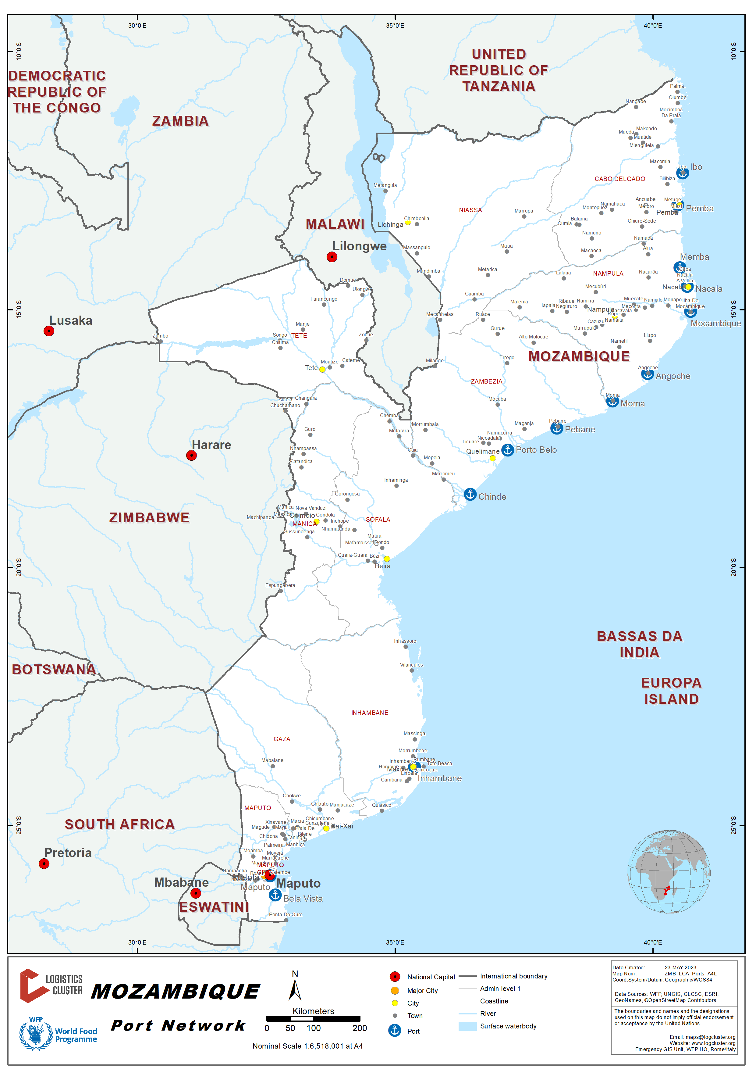
Mozambique is a country with a long coastline of approximately 2,500 km, providing access to the Indian Ocean, extending from South Africa in the south to Tanzania in the north. The country has several major ports along its extensive coastline, including the ports of Maputo, Beira, and Nacala, which serve as critical gateways for international trade, for neighbouring countries of Eswatini, South Africa, Zimbabwe, Botswana, Zambia, DRC and Malawi.
The Port of Maputo is the largest and busiest port in Mozambique, located in the capital city of Maputo at the southern end of the country. It handles the majority of Mozambique's imports and exports, including containerized cargo, dry bulk cargo, and liquid bulk cargo. The port is also strategically located for trade with neighbouring countries such as Zimbabwe, Eswatini and South Africa.
The Port of Beira, located in central Mozambique, is the second-largest port in the country and a vital gateway for landlocked countries such as Zimbabwe, Zambia and Malawi. It handles a wide range of cargo, including coal, iron ore, and other minerals, as well as containerized cargo.
The Port of Nacala is located in the northern part of Mozambique and is primarily used for the export of coal from the nearby Moatize coal mines. It is also an important hub for the export of other commodities such as agricultural products.
Comprehensive railway and road networks link these ports to neighbouring countries and the landlocked provinces of Mozambique. Other smaller ports exist, such as Quelimane and Pemba that serve mostly nearby businesses and communities.
Overall, Mozambique's port network plays a critical role in facilitating international trade and economic development in the country and the broader Southern African region.

2.1.2 Mozambique Port of Maputo
Port Overview
The port of Maputo is the largest port in Mozambique, connected to an extensive rail and road network. It serves the Mozambique provinces of Maputo and Gaza and offers a short and viable access route for import and export cargoes from South Africa (Gauteng, Limpopo and Mpumalanga provinces mainly), Swaziland, Zimbabwe (Matabeleland) and Botswana. More than 80% of handled cargo is in transit to/from neighbouring countries.
In total, the port has 16 linear berths totalling approximately 4,000 metres.
A renewable 25-year concession to manage and develop the port was awarded to an international port management consortium (Portus Indico), which subsequently formed a Mozambican joint venture with CFM – the Maputo Port Development Company (MPDC).
The approach channels have recently been restored to design depth and continuous 24/7 port operations have been established. Vessels have a choice of two channels (North or South) to reach the Pilot Station at Buoy 6. Using the South Channel saves about 11 miles for vessels arriving from the South, but this channel is subject to strong tidal sets. Pilotage through the Xefina and Polana channels into the berths is compulsory from Buoy 6.
There are two main components to the port, the Maputo Cargo Terminals, which include the container, bulk minerals, citrus, sugar and molasses terminals and, 6 km further upriver, the Matola Bulk Terminals with four deep-water berths for handling coal, fuel and lubricants, aluminium and grains.
Port website: http://www.cfm.co.mz/index.php/en/infraestruturas/cfm-south/port-of-maputo
Key port information may also be found at http://ports.com/mozambique/port-of-maputo/
http://ports.com/mozambique/port-of-matola/
http://www.maritime-database.com/port.php?pid=2291
|
Port Location and Contact |
|
|---|---|
|
Country |
Mozambique |
|
Province or District |
Maputo |
|
Nearest Town or City with Distance from Port |
Maputo |
|
Port's Complete Name |
Port of Maputo |
|
Latitude |
-25.9602 |
|
Longitude |
32.5454 |
|
Managing Company or Port Authority |
MPDC except for the following terminals in Matola:
|
|
Management Contact Person |
Kristina Abudo de Klerk |
|
Nearest Airport and Airlines with Frequent International Arrivals/Departures |
Maputo International Airport served by the following airlines: LAM, SAA, TAP, Qatar Airways, Turkish Airlines, Kenya Airways, Ethiopian Airlines, TAAG, Fast Jet |
Port Picture


Description and Contacts of Key Companies
For more information on port contacts, please see the following link: 4.3 Port and Waterways Companies Contact List
Port Performance
The Maputo Port’s access channel has a length of 48 Nautical
Miles that enables MSD of 14.40m (with neap tides) or 15.50m (with
spring tides).
Maximum LOA vessels depend on the category, but presently due to
quay length and design drafts alongside, 300m is the acceptable
size.
With the construction of Maputo-Katembe Bridge, limitations in air
draft for all vessels is 62.50m.
Waiting time also depends on the type of vessel: 2-4 hours for
containers and 12-24 hours for other types. Vessels with cargo for
internal consumption, such as rice, wheat, frozen fish, fuel, etc.
are given priority, as well as humanitarian cargo.
|
Seasonal Constraints |
||
|---|---|---|
|
Occurs |
Time Frame |
|
|
Rainy Season |
Yes |
From November to March |
|
Major Import Campaigns |
No |
|
|
Other Comments |
||
|
Handling Figures for 2017 |
|
|---|---|
|
Vessel Calls |
1,062 |
|
Container Traffic (TEUs) |
101,995 |
|
Handling Figures Bulk and Break Bulk for 2017 |
|
|---|---|
|
Bulk (mt) |
16,750,811 |
|
Break bulk (mt) |
1,467,333 |
Discharge Rates and Terminal Handling Charges
For information on port rates and charges, please see the following document: Maputo Port Tariffs.
Berthing Specifications
|
Type of Berth |
Quantity |
Length (m) |
Maximum Draft (m) |
Comments |
|---|---|---|---|---|
|
Cabotage Berth (1) |
1 |
293 |
7 |
|
|
Conventional Berth (3) |
1 |
263 |
9 |
Car carriers, Cruise liners and Naval vessels |
|
Conventional Berth (4) |
1 |
273 |
9 |
General cargo |
|
Conventional Berth (5) |
1 |
230 |
12 |
Bulk, Project and General cargo |
|
Conventional Berth (6) |
1 |
246 |
9.5 |
Molasses |
|
Conventional Berth (7) |
1 |
240 |
12 |
Bulk and general cargo |
|
Conventional Berth (8) |
1 |
202 |
12 |
Bulk sugar |
|
Conventional Berth (9) |
1 |
436 |
12 |
Bulk chrome, ferro-chrome and nickel |
|
Container Berth (10) |
1 |
308 |
12 |
|
|
Conventional Berth (11) |
1 |
177 |
12 |
Bulk clinker, gypsum, magnetite, and coal |
|
Conventional Berth (12) |
1 |
169 |
12 |
Vegetable oil |
|
Silo Berth |
1 |
210 |
9.5 |
Managed by Grindrod/Stema |
|
Matola Coal Terminal |
1 |
220 |
15.4 |
Bulk coal and magnetite. |
|
Oil Jetty |
1 |
230 |
11.5 |
Managed by Oil Tanking Mozambique |
|
Aluminium terminal |
1 |
230 |
12 |
Managed by Mozal |
|
Berthing Tugs (2) |
1 |
220 |
7.2 |
|
|
Water Barges |
n.a. |
|
General Cargo Handling Berths
|
Cargo Type |
Berth Identification |
|---|---|
|
Imports - Bagged Cargo |
Nr 4 and 5 |
|
Exports - Bagged Cargo |
Nr 7 |
|
Imports and Exports - RoRo |
Nr 3 |
|
Other Imports |
n.a. |
Port Handling Equipment
Port equipment is owned by MPDC or by its sub-concessions within its terminals, e.g. container terminal, bulk sugar terminal, grain terminal, vegetable oils terminal, molasses terminal.
Fleet availability is about 85% and usually maintained by the appropriate agents of each manufacturer.
A third mobile crane has been purchased, which could trim a day off vessel berthing times.
|
Equipment |
Available |
Total Quantity and Capacity Available |
Comments on Current Condition and Actual Usage |
|---|---|---|---|
|
Dockside Crane |
Yes |
||
|
Container Gantries |
Yes |
||
|
Mobile Cranes |
Yes |
1 x 60 tons 2 x 144 tons |
|
|
Reachstacker |
Yes |
||
|
RoRo Tugmaster (with Trailer) |
Yes |
24 tractors and 41 trailers |
|
|
Grain Elevator with Bagging Machines |
Yes |
||
|
Transtainer |
Yes |
||
|
Forklifts |
Yes |
2 x 2.5 tons 2 x 4.5 tons 6 x 7 tons 2 x 7.5 tons 2 x 15 tons 1 x 24 tons 5 x 28 tons 2 x 40 tons |
|
|
Pay loaders |
Yes |
15 |
|
|
Excavators |
Yes |
6 x 20 tons |
|
Container Facilities
|
Facilities |
20 ft. |
40 ft. |
|---|---|---|
|
Container Facilities Available |
|
|
|
Container Freight Station (CFS) |
MICD (Maputo Intermodal Container Depot):
|
|
|
Refrigerated Container Stations |
n/a |
|
|
Other Capacity Details |
Annual 300,000 TEU capacity |
|
|
Daily Take Off Capacity |
900-1,000 Containers per day |
|
|
Number of Reefer Stations |
196 reefer plugs |
|
|
Emergency Take-off Capacity |
n/a |
|
|
Off take Capacity of Gang Shift |
n/a |
Customs Guidance
Customs regulations in Mozambique combine SADC regional integration requirements with existing local procedures, depending on the cargo being cleared. Principal legislation, contacts and other useful customs-related information is available from the Mozambican Customs Authority (www.alfandegas.gov.mz)
The process of application for exemption of duties comprises following steps:
- Accreditation and licensing to operate in Mozambique with special diplomatic status for duty free imports.
- Before the arrival of the cargo submission of:
Commercial invoice
Packing List
Application to Customs with justification for exemption - Customs clears the goods that can be exempted from duties, through the JUE (“Janela Única Eletrónica” or Electronic Single Window).
- For the submission to JUE, the following is required:
Commercial invoice
Transport document (original)
Packing List
Customs clearance document - JUE issues a notice of payment (AP).
- Deduction of import duties at JUE:
- The AP is taken physically to Tax Department to apply respective deduction of the value of the import duties.
- Once this step is finalized, the customs clearance process can be completed.
For more information on customs in Mozambique, please see the following link: 1.3 Customs Information
Terminal Information
MULTIPURPOSE TERMINAL
The MICD terminal comprises a warehouse with 8,000m2, container yard for 2,500 TEUs empties and 300 TEUs full and 8,000 m2 open storage for bulk packing slab. The terminal offers a wide variety of container related services:
- Container storage
- Container inspections
- Cleaning of containers
- Light container repairs
- Pre-trip inspections on reefer containers
- Receiving bulk cargoes and pack into containers
- Receiving and warehousing of unitised cargoes for packing into containers
- De-stuffing of containers, warehousing of cargo and loading onto road vehicles
- Warehouse approved by PPECB for ambient packing of fruits
The port has general cargo berth with two Ro-Ro access ramp points (263 and 285m berth length respectively).
GRAIN AND BULK HANDLING
The bulk grain terminal at MPDC, operated by MGT, is comprised of 5 silos with 5,000 tons capacity each. The annual handling capacity is 200,000 tons. Kemmie is responsible for bagging and direct bagging from ship discharge.
MAIN STORAGE TERMINAL
|
Storage Type |
Number of Storage Facilities |
Area (m2) |
|---|---|---|
|
Bagged Cargo |
One |
2,504 |
|
Refrigerated Cargo |
n.a. |
n.a. |
|
General Cargo |
Two |
1,972 + 1,784 |
Stevedoring
The following companies perform stevedoring activities in the port of Maputo:
RGB – https://www.freightnet.com/profile/154340.htm/
Manica Moçambique – http://www.manica.co.mz/
Unidos Serviços
Mozport Maputo – http://www.supermaritime.com/offices/maputo/
Hinterland Information
The main customers of the port of Maputo are from neighbouring countries and make use of the following three railway lines:
- Ressano Garcia Line to the South Africa border (88 km). There is a partial concession for iron ore traffic with Transnet.
- Goba Line to the Swaziland border (71 km). Operated by CFM Sul.
- Limpopo Line to the Zimbabwe border (522 km). Operated by CFM Sul.
The road connection to South Africa, Zimbabwe and Swaziland is in good condition. However, road traffic to Zimbabwe and Botswana still transits mainly through South Africa at present.
The road network that links the port with the Provinces of Maputo, Gaza and Inhambane is also paved and in reasonably good condition.
Port Security
|
Security |
|
|---|---|
|
ISPS Compliant |
Yes |
|
Current ISPS Level |
1 |
|
Police Boats |
Yes |
|
Fire Engines |
Yes |
Mozambique - 2.1.1 Mozambique Port of Beira
Port Overview
The Port of Beira is the second largest port in Mozambique. It is located at the mouth of the Púngue River, 20 km from the open sea and about 1,200 km north of Maputo.
Served by extensive rail and road network systems, Beira is the main port for exports and imports from the Mozambique provinces of Sofala, Manica and Tete, and a strategic gateway for the landlocked countries in southeast Africa. It provides a short and quick access route for transit cargoes to/from Zimbabwe, Malawi, Zambia, Botswana and DRC. A fuel pipeline also links the port with Zimbabwe.
The port of Beira has 11 berths stretching over a total length of 1,994 m. This excludes berth nr. 1, which is reserved as a fishing harbour. ‘Cornelder de Moçambique’ (CdM), a joint venture between the state-owned Mozambique Ports and Railways (CFM) and Cornelder Holding from the Netherlands, has operated it since 1998 with concession for CT and GC excluding Oil terminal and Coal Terminal (TCC8) which are operated by CFM.
Beira is a tidal port – pilotage and tug assistance is always therefore compulsory. Access to the port is made through the 135 m wide dredged Macuti Channel (17 nautical miles from the Macuti lighthouse), with an actual minimum depth of 8 m below the chart datum in the Macuti curve. Systematic dredging is required to maintain the channel depths and width. The maximum accepted draft is obtained by adding 6.8 m to the height of the tide at that moment. This includes a safety margin of 1.2 m of the keel clearance.
The Terminals operated by Cornelder de Moçambique can receive ships with a maximum tonnage of 40,000 tons, 24 hours a day. Vessels awaiting berth must anchor at the pilot station.
Port of Beira has benefited of some investments by Cornelder. The Container terminal benefitted from an investment to increase the capacity of its container storage space to an area of 3 ha, as well as the building of a new five lane access road, with the option to add a further two lanes in the future. There has been investment in equipment such as in terminal tractors, reachstackers, RoRo tugmasters, forklifts, weighbridges. With the projection expansion of storage yard, in addition to using Rubber Tyred Gantry Cranes (RTG´s) the port will be able to handle 700,000.00 TEU.
The Container Port Performance Index (CPPI) is produced by the World Bank and ranks ports based on a statistical approach, which is based on ship waiting time in port. Port of Beira achieved the highest ranking of all container terminals in southern Africa, ahead of Ports such as Durban, Cape Town, Dar Es Salaam and Walvis Bay.
Port website: Cornelder || Port of Beira - Mozambique
Key port information may also be found at: Port of Beira MZBEW map, contact details and vessel arrivals by Maritime Database (maritime-database.com)
|
Port Location and Contact |
|
|---|---|
|
Country |
Mozambique |
|
Province or District |
Sofala |
|
Nearest Town or City with Distance from Port |
Beira Port in town |
|
Port's Complete Name |
Port of Beira |
|
Latitude |
-19.8461 |
|
Longitude |
34.8576 |
|
Managing Company or Port Authority
|
Cornelder de Mozambique |
|
Management Contact Person |
Leticia Ferreira (Comercial Director) – +258828732724, +25823322735 |
|
Nearest Airport and Airlines with Frequent International Arrivals/Departures |
Beira International Airport LAM and SAA |
Port Picture


Description and Contacts of Key Companies
Cornelder Mozambique is the managing company for Port of Beira.
For more information on port contacts, please see the following link:
4.4 Port and Waterways Companies Contact List
Port Performance
Beira is a tidal port – pilotage and tug assistance is always therefore compulsory. Access to the port is made through the 135 m wide dredged Macuti Channel, with an actual minimum depth of 8 m below the chart datum in the Macuti curve.
The port of Beira is not congested. It is able to receive ships with a maximum tonnage of 40,000 tons, 24 hours a day. Berth occupancy in 2017 was 59 percent at the container terminal and 80 percent at general cargo berths. Despite the increased tonnage handled, the container terminal is not congested. Container dwelling time is less than ten days. Regarding bulk cargo (e.g., maize, wheat), productivity is around 150 mt/gang/hour, and bagged cargo averages 30 mt/gang/hour.
Restricted road access to the port (roads are very narrow) and bureaucratic delays in the documentation process constitute the main constraints.
There is an established priority for humanitarian cargo at the Port of Beira, particularly during times of crisis or natural disasters. The port has played a crucial role in supporting humanitarian operations during cyclones and other emergencies.
|
Seasonal Constraints |
||
|---|---|---|
|
|
Occurs |
Time Frame |
|
Rainy Season |
Yes |
From November to March |
|
Major Import Campaigns |
Yes, Fertilizer |
From August to January |
|
Other Comments |
There was a total of ten days without navigation in 2022 due to a declared bad weather condition. |
|
|
Handling Figures for 2022 |
|
|---|---|
|
Vessel Calls |
CT: 139 GC: 168 |
|
Container Traffic (TEUs) |
258,570 |
|
Handling Figures Bulk and Break Bulk for 2022 |
|
|---|---|
|
Bulk (mt) |
2,575,990 |
|
Break bulk (mt) |
766,159 |
Discharge Rates and Terminal Handling Charges
For information on port rates and charges, please see the following link:
Cornelder || Port of Beira - Mozambique
CdM Tariff Book 2012 -CdM_Tariff_2012 (cornelder.co.mz)
Cornelder Tariff Book includes all tariffs except maritime services, which are included in the CFM Port Tariffs.
Berthing Specifications
|
Type of Berth |
Quantity |
Length (m) |
Maximum Draft (m) |
Comments |
|---|---|---|---|---|
|
Conventional Berth (6) |
1 |
170 |
10 |
General cargo |
|
Conventional Berth (7) |
1 |
165.5 |
10 |
General cargo |
|
Conventional Berth (8) |
1 |
187.9 |
10 |
Coal terminal berth |
|
Conventional Berth (9) |
1 |
167.3 |
10 |
General cargo/Silo berth |
|
Conventional Berth (10) |
1 |
167.3 |
10 |
General cargo/Silo berth |
|
Container Berths (2 to 5) |
4 |
645 |
12 |
Container/General cargo |
|
Silo Berth (9 and 10) |
2 |
167.3 |
10 |
General cargo/Silo berth |
|
Berthing Tugs |
2 |
n/a |
n/a |
n/a |
|
Water Barges |
n/a |
|
|
|
General Cargo Handling Berths
|
Cargo Type |
Berth Identification |
|---|---|
|
Imports - Bagged Cargo |
Nr. 6 to 10 |
|
Exports - Bagged Cargo |
Nr. 6 to 10 |
|
Imports and Exports - RoRo |
Nr. 6 to 10 |
|
Other Imports |
Nr. 6 to 10 |
Port Handling Equipment
Cornelder, a joint venture between CFM, Cornelder Holland and current concessionaires, manages the port equipment.
Over the year 2022, gantry crane availability was 93 percent, reach stacker availability was 69 percent and terminal tractor availability was 72 percent.
|
Equipment |
Available
|
Total Quantity and Capacity Available |
Comments on Current Condition and Actual Usage |
|---|---|---|---|
|
Dockside Crane |
No |
|
|
|
Container Gantries |
Yes |
2 x 50 tons 2 x 60 tons |
STS Gantry cranes are fully operational. |
|
Mobile Cranes |
Yes |
3 material handlers 1 mobile crane 28 tons |
|
|
Reachstacker |
Yes |
31 Sany |
All operational |
|
RoRo Tugmaster (with Trailer) |
Yes |
15 x 40 tons 15 x 60 tons 21 X 70 tons |
All operational |
|
Grain Elevator with Bagging Machines |
Yes |
6 mobile bagging units, including hoppers 14 Bulk hoppers |
|
|
Transtainer |
No |
|
|
|
Forklifts |
Yes |
2 x 3 tons 6x2.5 tons 6 x 16 tons 5 x 30 tons 2x46 tons 2 x 50 tons 3 x empty handler
|
|
|
Weighbridges |
Yes |
6 |
|
|
Terminal Tractors |
Yes |
45 |
|
Container Facilities
The terminal has been working with Navis N4 Version 3.6 since 2016. The control of the yard, the truck flow and vessel operations has improved and container traffic has increased. The average yard utilisation was 6,000 TEU and the truck turnaround time is less than one hour. Crane productivity is in average 20 GMPH, 20 containers moved over the quay wall per hour.
|
Facilities |
20 ft |
|---|---|
|
Container Facilities Available |
n/a |
|
Container Freight Station (CFS) |
No |
|
Refrigerated Container Stations |
144 |
|
Other Capacity Details |
Storage for 10,000 TEU Dwell time less than 10 days Railside Gantry 40 tons |
|
Daily Take Off Capacity |
1,500 TEU |
|
Number of Reefer Stations |
148 |
|
Emergency Take-off Capacity |
n/a |
|
Off take Capacity of Gang Shift |
n/a |
Customs Guidance
Guidance from the manual “Rules and Procedures for Customs clearance of Goods donated for Humanitarian Assistance”, prepared by INGD, Mitigation Division, Customs clearance Sector - Ver12December 22:
VI. CUSTOMS CLEARANCE PROCESS FOR THE HEALTH AND EMERGENCY AND HUMANITARIAN GOODS SECTOR
6.1. Conditions for Customs Clearance
25. Advance shipment (after shipment and before arrival in the national territory) by the exporter/Donor of the following documents:
-
Commercial Invoice;
-
PackList;
-
Certificate of Analysis (Drugs and vaccines) or Quality (Consumables and other medical products);
-
Bill of Lading (Bill of lading) for sea and Waybill for air;
-
Processing schedule for the Pharmaceutical Specialty Inspection Bulletin (BIEF), in accordance with Annex 2.
26. Immediate Issuance (within no more than 2 days) of the Accounting Note, in cases of lack of financial coverage, an early exit authorization would be issued for products subject to Customs Charges (most consumables). If the Accounting Note is not issued within 2 days, the products destined for the MISAU (medicines, medical products, equipment and vehicles) will enjoy early departure without any restrictions.
27. Existence of financial availability within the limit communicated in the State Budget for the payment of MCNet Fee up to the maximum amount equivalent to sixty-four American dollars (USD 64) in accordance with paragraph 30, and expenses of Private agents of cargo handling (airport tax, storage, parking, deposit and Kudumba) upon arrival of the Goods.
28. For perishable products such as vaccines and reagents, the request for Exit Authorization must be made at the respective customs office, with a maximum of two (2) days in advance, under the responsibility of the Manager or his Representative. Clearance of vehicles and other vehicles.
6.2. Clearance of vehicles and other vehicles
29. The attribution of license plates for vehicles and other vehicles must be made before issuing the Accounting Notes, through Early Departure, in case of delay in this process.
6.3 Payment of the MCNet Fee
30. Bearing in mind that MISAU imports goods with high values, you must pay an MCNet fee up to a maximum amount equivalent to sixty-four American dollars (USD 64), regardless of the FOB value of the goods.
6.4 Payment of port fees
31. Private operator agents must allow the collection of goods intended for Health under a Term of Commitment, with the guarantee that the amounts due are paid within a period to be agreed between this agent and any Ministry authorized to receive or import emergency goods or humanitarians.
32. If the above conditions are met, the time for withdrawing the goods from the port area may be between:
-
Maximum 2 days for air and land cargo;
-
Maximum 7 days for sea cargo.
For more information on customs in Mozambique, please see the following link:
Terminal Information
MULTIPURPOSE TERMINAL
The container and multi-purpose terminal has a 645 m long quay with a 12 m depth alongside. The terminal has a 300,000 m² container yard, accommodating 10,000 TEUs and 148 electricity connection points for refrigerated containers. The container storage yard was recently expanded and covers now an area of 8,400 m² secure bonded transit warehouse and 3,650 m² covered storage. The road access was also improved and has now five lanes with an option for further extension. Currently the terminal uses the NAVIS N4 terminal operating system and can handle 300,000 TEU per year. With the projection expansion of storage yard, in addition to using Rubber Tyred Gantry Cranes (RTG´s) the port will be able to handle 700,000.00 TEUs.
GRAIN AND BULK HANDLING
CdM does not manage this terminal. It can handle 4,000 to 5,000 tons per day and has a silo storage capacity of 50,000 tons. Main commodities include fertilizer, clinker, sulphur and ore chrome + ferrochrome.
MAIN STORAGE TERMINAL
|
Storage Type |
Number of Storage Facilities |
Area (m2) |
|---|---|---|
|
Bagged Cargo |
5 covered warehouses |
15,000 |
|
Refrigerated Cargo |
n/a |
n/a |
|
General Cargo |
Paved open air storage |
15,000 (paved) + 150,000 |
|
Bulk Silo Storage |
For cereals |
50,000 tons |
Stevedoring
The following companies perform stevedoring activities in the port of Beira:
-
Chele Serviços e Consultoria – Home • CSC | Chele Services and Consulting, Lda.
-
BMP
-
Chigolo
-
Marperita – Marperita | About Us (marperita-mozambique.com)
-
Mozport Beira – Beira - Supermaritime Group
-
Naval Serviços à Navegação
Hinterland Information
The port is served by two railway lines: one to Zimbabwe via Machipanda/Mutare (317 km to the border) operated by CFM, and Sena line to Moatize, Tete Province, (575 km) operated by CFM with a partial concession to ICVL and Jindal for the transport of coal from Moatize. Discussions are underway between the governments of Mozambique, Malawi and Zambia, to extend the line to Mozambique’s neighbours, which could provide a significant boost to the trading potential of all the countries involved.
The road network serving the port is in reasonably good condition and enables the movement of trucks and international trade to/from Zimbabwe, Botswana (via Zimbabwe), Malawi and Zambia (via Zimbabwe, Malawi or directly via Tete Province). It also provides an easy route to access markets in Mozambique provinces of Sofala, Manica, Tete and Zambézia. The EN6 highway has benefitted from a USD 410 million upgrade to ensure it can continue to meet traffic demand. The work done to avoid flooding by the Pungue river showed foresight given the damages caused by Cyclone Idai.
The shortest, quickest and safest route to the sea for the southern Africa hinterland:

Port Security
The port has a 6 km long electro-welded security fencing and a CCTV surveillance system, which complies with international security standards.
Adequate safety procedures during cargo handling are in place.
|
Security |
|
|---|---|
|
ISPS Compliant |
Yes |
|
Current ISPS Level |
1 |
|
Police Boats |
No |
|
Fire Engines |
Yes (3) |
Disclaimer: Inclusion of company information in the LCA does not imply any business relationship between the supplier and WFP / Logistics Cluster, and is used solely as a determinant of services, and capacities.
Please note: WFP / Logistics Cluster maintain complete impartiality and are not in a position to endorse, comment on any company's suitability as a reputable service provider.
Mozambique - 2.1.3 Mozambique Port of Nacala
Port Overview
The port of Nacala is located in the province of Nampula within a protected bay with 60 m deep and 800 m wide at the entrance. It features exceptional navigability conditions, allowing the movement of ships 24 hours per day without restrictions, except along the pier with a 9-14 m draft, and is the only deep-water port of Mozambique and the largest in the entire east Africa coast.
The port is connected to Malawi and to Niassa province by rail and offers a key access route for import and export cargoes from Malawi, Zambia and the Tete province (mainly coal exports). The road network serves other national destinations in Nampula, Zambézia, Cabo Delgado provinces and Niassa.
The main components of the port are: (i) General cargo berths; (ii) Container berth; (iii) Liquid Bulk Terminal, connected to a fuel tank through a pipeline with 3.5 km and seven deposits for vegetable oils. It has a general cargo terminal with four docks, one warehouse in a covered area of 9,000 m2 and open-air storage of 60,000 m2.
The Port of Nacala returned to Portos e Caminhos de Ferro de Moçambique (CFM) management by decision of the Government of Mozambique announced in December 2019, following the end of the concession contract signed with the North Development Corridor (CDN) in 2000.
Currently substantial investment is being undertaken and includes the complete rehabilitation of the port facilities, dredging, construction of access roads, and investing in equipment. The project "Nacala Port Development Project" include dredging for a quay wall, expanding the harbor by reclaiming land, paving a container pier, installing an access road and on-site rail, and providing equipment to improve the efficiency of cargo handling. The rehabilitation, expansion, and modernization works were financed by the Japanese Development Agency (JICA), which disbursed USD 277.5 million and is expected to be concluded in 2023.
The port plans to increase its cargo handling capacity of 50 TEU per hour, from 100,000 TEU yearly to 252,000 TEU, a growth of over 150 percent, after the conclusion of the rehabilitation, expansion and modernisation works. Storage capacity is also expected to increase by 8,000 TEU (5,000 TEU previously), as well as berthing of large ships (80,000 DWT - Post Panamax, compared to previous 60,000 DWT).
At present, most of the traffic is import/export cargo from Mozambique, although the potential for transit traffic is enormous. Transit cargo represents just 4.8 percent in TEUs and 10 percent bulk. However, Nacala Port is expected to be the principal gateway providing efficient logistics services not only for the northern part of Mozambique but also for landlocked countries in its hinterland. It is forecasted to increase the annual cargo volume by ten times in 2030 compared to 2011. Furthermore, the port has the potential to become the hub port which serves for the larger area in south-eastern Africa, taking advantage of its deep-water basin.
Port website: Porto de Nacala (cfm.co.mz)
Key port information may also be found at: Port of Nacala MZMNC map, contact details and vessel arrivals by Maritime Database (maritime-database.com)
|
Port Location and Contact |
|
|---|---|
|
Country |
Mozambique |
|
Province or District |
Nampula |
|
Nearest Town or City with Distance from Port |
Nacala, 0 km |
|
Port's Complete Name |
Nacala Port |
|
Latitude |
-14.533056 |
|
Longitude |
40.666667 |
|
Managing Company or Port Authority |
Portos e Caminhos de Ferro de Moçambique (CFM) |
|
Management Contact Person |
Neimo Induna (+258849012166) |
|
Nearest Airport and Airlines with Frequent International Arrivals/Departures |
Nacala International Airport LAM and charter flights |
Port Picture


Description and Contacts of Key Companies
CFM Norte, Nacala Delegation manages the port.
For more information on port contacts, please see the following link:
4.4 Port and Waterways Companies Contact List
Port Performance
The port has no channel restrictions. 261 vessels called the port in 2022, 16 percent less than 2021 (310 vessels) and 2.740.369 mt were handled. Mozambique export traffic (mainly agriculture cargo) has the larger share of the traffic. Berth occupancy rates are around 57.1 percent in 2022.
Priority for humanitarian cargo is easily negotiable.
|
Seasonal Constraints |
||
|---|---|---|
|
|
Occurs |
Time Frame |
|
Rainy Season |
No |
|
|
Major Import Campaigns |
No |
|
|
Other Comments |
|
|
|
Handling Figures for 2022 |
|
|---|---|
|
Vessel Calls |
261 (310 in 2021) |
|
Container Traffic (TEUs) |
66,588 (73,915 in 2021) |
|
Handling Figures Bulk and Break Bulk for 2022 |
|
|---|---|
|
Bulk (mt) |
2.740,369 mt (2.882,400 mt in 2021) |
|
Break bulk (mt) |
|
Discharge Rates and Terminal Handling Charges
For information on port rates and charges, please see the following link:
Berthing Specifications
|
Type of Berth |
Quantity |
Length (m) |
Maximum Draft (m) |
|---|---|---|---|
|
Conventional Berth |
4 |
200+160+200+200 |
9 – 14 |
|
Container Berth |
2 |
200+200 |
14 |
|
Silo Berth |
1 |
152 |
7.5 – 10 |
Port Handling Equipment
CFM Norte, Nacala Delegation manages the port.
|
Equipment |
Available
|
Total Quantity and Capacity Available |
Comments on Current Condition and Actual Usage |
|---|---|---|---|
|
Dockside Crane |
Yes |
|
|
|
Container Gantries |
Yes |
2 x 45 tons |
Good |
|
Mobile Cranes |
Yes |
8 x RTG |
Good |
|
Reachstacker |
Yes |
10 x 45 tons |
Good |
|
RoRo Tugmaster (with Trailer) |
Yes |
2 |
Good |
|
Grain Elevator with Bagging Machines |
Yes |
2 x vacuvators 2 x hoppers Several bagging machines |
Good |
|
Transtainer |
|
|
|
|
Forklifts |
Yes |
1x 2.5 tons 1x 3 tons 1x 42 tons 1x 40 tons
|
Good |
Container Facilities
The port plans to increase its cargo handling capacity of 50 TEU per hour, from 100,000 TEU yearly to 252,000 TEU, a growth of over 150 percent, after the conclusion of the rehabilitation, expansion and modernisation works. Storage capacity is also expected to increase by 8,000 TEU (5,000 TEU previously), as well as berthing of large ships (80,000 mt compared to previous 60,000 mt).
|
Facilities |
20 ft |
40 ft |
|---|---|---|
|
Container Facilities Available |
Yes |
Yes |
|
Container Freight Station (CFS) |
Yes |
Yes |
|
Refrigerated Container Stations |
Yes |
|
|
Daily Take Off Capacity |
400 |
400 |
|
Number of Reefer Stations |
96 + 210 |
|
|
Emergency Take-off Capacity |
400 |
|
|
Off take Capacity of Gang Shift |
200x2 |
|
Customs Guidance
Guidance from the manual “Rules and Procedures for Customs clearance of Goods donated for Humanitarian Assistance”, prepared by INGD, Mitigation Division, Customs clearance Sector - Ver12December 22:
VI. CUSTOMS CLEARANCE PROCESS FOR THE HEALTH AND EMERGENCY AND HUMANITARIAN GOODS SECTOR
6.1. Conditions for Customs Clearance
25. Advance shipment (after shipment and before arrival in the national territory) by the exporter/Donor of the following documents:
-
Commercial Invoice;
-
PackList;
-
Certificate of Analysis (Drugs and vaccines) or Quality (Consumables and other medical products);
-
Bill of Lading (Bill of lading) for sea and Waybill for air;
-
Processing schedule for the Pharmaceutical Specialty Inspection Bulletin (BIEF), in accordance with Annex 2.
26. Immediate Issuance (within no more than 2 days) of the Accounting Note, in cases of lack of financial coverage, an early exit authorization would be issued for products subject to Customs Charges (most consumables). If the Accounting Note is not issued within 2 days, the products destined for the MISAU (medicines, medical products, equipment and vehicles) will enjoy early departure without any restrictions.
27. Existence of financial availability within the limit communicated in the State Budget for the payment of MCNet Fee up to the maximum amount equivalent to sixty-four American dollars (USD 64) in accordance with paragraph 30, and expenses of Private agents of cargo handling (airport tax, storage, parking, deposit and Kudumba) upon arrival of the Goods.
28. For perishable products such as vaccines and reagents, the request for Exit Authorization must be made at the respective customs office, with a maximum of two (2) days in advance, under the responsibility of the Manager or his Representative. Clearance of vehicles and other vehicles.
6.2. Clearance of vehicles and other vehicles
29. The attribution of license plates for vehicles and other vehicles must be made before issuing the Accounting Notes, through Early Departure, in case of delay in this process.
6.3 Payment of the MCNet Fee
30. Bearing in mind that MISAU imports goods with high values, you must pay an MCNet fee up to a maximum amount equivalent to sixty-four American dollars (USD 64), regardless of the FOB value of the goods.
6.4 Payment of port fees
31. Private operator agents must allow the collection of goods intended for Health under a Term of Commitment, with the guarantee that the amounts due are paid within a period to be agreed between this agent and any Ministry authorized to receive or import emergency goods or humanitarians.
32. If the above conditions are met, the time for withdrawing the goods from the port area may be between:
-
Maximum 2 days for air and land cargo;
-
Maximum 7 days for sea cargo.
For more information on customs in Mozambique, please see the following link:
Terminal Information
MULTIPURPOSE TERMINAL
The container and multi-purpose terminal has a 372 m long quay with a 14 m depth alongside.
GRAIN AND BULK HANDLING
The Liquid Bulk Terminal, forms part of Quay 4, the General Cargo Terminal, has a depth of 9,7 m and is connected to the fuel tanks (BP Mozambique (12,000 m3 ), Petromoc (28,000 m3 ) and Camel (32.000 m3 )) and to the vegetable oil tanks with a storage capacity of 13,111 m3 (CFM, SanOil) through a 3,5 km pipeline.
-
Quay Bridge Features: rectangle shaped with a length of 120 m and 25 m wide;
-
Major Anchor Commodities: Fuel (Diesel, Petrol and Jet A1); Vegetable Oils (Palm Oil and PFAD).
The Bulk Liquids Terminal registered an increasing trend in the national imports of liquid bulk with major incidence to fuel as a result of increased storage capacity and the commissioning of new Terminal - Camel, Lda with 32.000 m3 capacity for fuel.

MAIN STORAGE TERMINAL
|
Storage Type |
Number of Storage Facilities |
Area (m2) |
|---|---|---|
|
Bagged Cargo |
|
9,000 |
|
Refrigerated Cargo |
|
|
|
General Cargo |
|
60,000 |
Stevedoring
Stevedoring labour force exclusively supplied by Portos do Norte (PN).
Hinterland Information
The port was primarily designed as a main gateway for the import and export cargoes from Malawi that uses the railway line. In recent years, the north of Mozambique has shown significant development that also generates cargo for the Port of Nacala; hence increased influence of domestic traffic at the port vis-à-vis transit cargo. The railway line to Malawi and beyond to Zambia, DRC and Tete province offers today a good and reliable link. The other domestic traffic is moved by road, covering mainly the provinces of Nampula and Cabo Delgado and the northern part of Zambézia province and Niassa.
Port Security
Nacala Port was registered and accredited in 2007 as being compliant of the ISPS security code. The port has gate checks all people working in the port are well identified with specific uniforms for better identification.
|
Security |
|
|---|---|
|
ISPS Compliant |
Yes |
|
Current ISPS Level |
1 |
|
Police Boats |
Yes (1) |
|
Fire Engines |
Yes |
Mozambique - 2.1.4 Mozambique Port of Quelimane
Port Overview
Quelimane is a small seaport 12.2 nautical miles up the Cuácua River (ex-Bons Sinais). It is a short and convenient route for the export of regional agricultural crops from the Province of Zambézia, such as rice, cotton, and forestry products, as well as shrimp and scrap metal.
With the decline of production during the civil war late last century, the exports almost came to a halt and the port fell into decline. However, following the end of the war and the concession to Cornelder Mozambique in 2004, the port underwent a rehabilitation programme that included a new concrete quay of 230 m long, and is now in good operational conditions. The Government and Cornelder agreed in December 2017 to end the concession agreement and the port management returned to Mozambique Ports and Railways Administration (CFM).
All the offices of Government institutions can be found at the Port: Customs, Immigration, Maritime Service, Agriculture and Port Police. Agents are not allowed to have their operational Offices inside the port area.
The electric power supply is stable; notwithstanding, a 250 KVA generator always ensures power supply, mainly for the cold chain installations and the security lighting along the security fence that surrounds the port area.
The road network that leads to Quelimane is mostly paved to the South (Caia), to the North (Mocuba and further to Nampula and Nacala), and to the West (Milange at the border with Malawi).
Quelimane is also connected to the Zambezi River by inland waterways. Previously, Companhia de Sena Sugar Factory at Marromeu used barges for sugar exports through Quelimane, however nowadays exports are through Beira.
Rehabilitation of infrastructure on the pier and container terminal took place in Port of Quelimane, as well as dredging the access channel. This rehabilitation allowed for the expansion of the handling capacity of the container and general cargo terminal, allowing the manoeuvring basin, with a width of 200 meters, to reach a depth of 5 m, against the previous 2 to 3 m.
Port website:
https://www.cfm.co.mz/index.php/pt/infraestruturas/porto-de-quelimane-centro
Key port information may also be found at: Port of Quelimane MZUEL map, contact details and vessel arrivals by Maritime Database (maritime-database.com)
|
Port Location and Contact |
|
|---|---|
|
Country |
Mozambique |
|
Province or District |
Zambézia |
|
Nearest Town or City with Distance from Port |
Quelimane, in town |
|
Port's Complete Name |
Porto de Quelimane |
|
Latitude |
-17.879090 |
|
Longitude |
36.879420 |
|
Managing Company or Port Authority
|
Portos e Caminhos de Ferro de Moçambique (CFM) |
|
Management Contact Person |
Dr. A. Conde (825503020, 846624724, 875503020) Engº Sábado Mune Juliasse (825774400, 842280980) |
|
Nearest Airport and Airlines with Frequent International Arrivals/Departures |
Aeroporto de Quelimane LAM operates only domestic flights to/from Quelimane |
Port Picture


Description and Contacts of Key Companies
CFM Centro, Zambézia Delegation manages the port.
For more information on port contacts, please see the following link:
4.4 Port and Waterways Companies Contact List
Port Performance
The channel draft is 4.9 - 6.1 m (tidal) and the maximum vessel size is 150 m in length. The major limitation of the port is the access channel draft. This limits the size of vessels that can access the port. Vessels with a draft of more than 3.5 meters are subject to navigational restrictions and require additional maneuvering time. The port of Quelimane is not currently congested and has a relatively low waiting time for vessels to berth. However, this can vary depending on factors such as weather conditions, vessel size, and cargo type.
There is no established priority for humanitarian cargo at the port of Quelimane. However, the port does have facilities to handle such cargo and works closely with humanitarian organizations to facilitate their operations.
One of the major limitations of the port of Quelimane is its limited infrastructure. The port's handling capacity is relatively low, and it lacks modern equipment and facilities. Additionally, the port is only accessible to smaller vessels due to its shallow channel draft.
|
Seasonal Constraints |
||
|---|---|---|
|
|
Occurs |
Time Frame |
|
Rainy Season |
Yes |
From November to March |
|
Major Import Campaigns |
No |
N/A |
|
Other Comments |
|
|
|
Handling Figures for 2021 |
|
|---|---|
|
Vessel Calls |
7 (5 in 2020) |
|
Container Traffic (TEUs) |
256 (671 in 2020) |
|
Handling Figures Bulk and Break Bulk for 2021 |
|
|---|---|
|
Bulk (mt) |
5,700 (7,700 in 2020) |
|
Break bulk (mt) |
|
Discharge Rates and Terminal Handling Charges
For information on port rates and charges, please see the following links:
Berthing Specifications
|
Type of Berth |
Quantity |
Length (m) |
Maximum Draft (m) |
Comments |
|---|---|---|---|---|
|
Conventional Berth |
N/A |
N/A |
N/A |
|
|
Container Berth |
Yes |
230 |
4.9 – 6.1 |
Channel draft is 4.9 - 6.1 m (tidal) |
|
Silo Berth |
N/A |
N/A |
N/A |
|
|
Berthing Tugs |
None |
N/A |
N/A |
There is just one pilot boat. |
|
Water Barges |
None |
N/A |
N/A |
|

General Cargo Handling Berths
|
Cargo Type |
Berth Identification |
|---|---|
|
Imports - Bagged Cargo |
Nr. 1 |
|
Exports - Bagged Cargo |
Nr. 1 |
|
Imports and Exports - RoRo |
Nr. 1 |
|
Other Imports |
Nr. 1 |
Port Handling Equipment
CFM Centro, Zambézia Delegation manages the port.
Sany and Kalmar reach Ssackers, mechanical spreader, port crane, forklift truck, Sisu terminal tractor, rough terrain forklift, three wheeled loaders.
|
Equipment |
Available
|
Total Quantity and Capacity Available |
Comments on Current Condition and Actual Usage |
|---|---|---|---|
|
Dockside Crane |
No |
|
|
|
Container Gantries |
No |
|
|
|
Mobile Cranes |
Yes |
1 x 45 mt |
Good |
|
Reachstacker |
Yes |
1 x 45 mt |
Good |
|
RoRo Tugmaster (with Trailer) |
No |
|
|
|
Grain Elevator with Bagging Machines |
No |
|
|
|
Transtainer |
No |
|
|
|
Forklifts |
Yes |
3 x 3 mt |
Good |


Container Facilities
The container facilities are very basic.
|
Facilities |
20 ft |
40 ft |
|---|---|---|
|
Container Facilities Available |
Yes |
Yes |
|
Container Freight Station (CFS) |
No |
No |
|
Refrigerated Container Stations |
16 |
16 |
|
Other Capacity Details |
|
|
|
Daily Take Off Capacity |
105 |
105 |
|
Number of Reefer Stations |
16 |
16 |
|
Emergency Take-off Capacity |
|
|
|
Off take Capacity of Gang Shift |
80 |
80 |

Customs Guidance
Guidance from the manual “Rules and Procedures for Customs clearance of Goods donated for Humanitarian Assistance”, prepared by INGD, Mitigation Division, Customs clearance Sector - Ver12December 22:
VI. CUSTOMS CLEARANCE PROCESS FOR THE HEALTH AND EMERGENCY AND HUMANITARIAN GOODS SECTOR
6.1. Conditions for Customs Clearance
25. Advance shipment (after shipment and before arrival in the national territory) by the exporter/Donor of the following documents:
-
Commercial Invoice;
-
PackList;
-
Certificate of Analysis (Drugs and vaccines) or Quality (Consumables and other medical products);
-
Bill of Lading (Bill of lading) for sea and Waybill for air;
-
Processing schedule for the Pharmaceutical Specialty Inspection Bulletin (BIEF), in accordance with Annex 2.
26. Immediate Issuance (within no more than 2 days) of the Accounting Note, in cases of lack of financial coverage, an early exit authorization would be issued for products subject to Customs Charges (most consumables). If the Accounting Note is not issued within 2 days, the products destined for the MISAU (medicines, medical products, equipment and vehicles) will enjoy early departure without any restrictions.
27. Existence of financial availability within the limit communicated in the State Budget for the payment of MCNet Fee up to the maximum amount equivalent to sixty-four American dollars (USD 64) in accordance with paragraph 30, and expenses of Private agents of cargo handling (airport tax, storage, parking, deposit and Kudumba) upon arrival of the Goods.
28. For perishable products such as vaccines and reagents, the request for Exit Authorization must be made at the respective customs office, with a maximum of two (2) days in advance, under the responsibility of the Manager or his Representative. Clearance of vehicles and other vehicles.
6.2. Clearance of vehicles and other vehicles
29. The attribution of license plates for vehicles and other vehicles must be made before issuing the Accounting Notes, through Early Departure, in case of delay in this process.
6.3 Payment of the MCNet Fee
30. Bearing in mind that MISAU imports goods with high values, you must pay an MCNet fee up to a maximum amount equivalent to sixty-four American dollars (USD 64), regardless of the FOB value of the goods.
6.4 Payment of port fees
31. Private operator agents must allow the collection of goods intended for Health under a Term of Commitment, with the guarantee that the amounts due are paid within a period to be agreed between this agent and any Ministry authorized to receive or import emergency goods or humanitarians.
32. If the above conditions are met, the time for withdrawing the goods from the port area may be between:
-
Maximum 2 days for air and land cargo;
-
Maximum 7 days for sea cargo.
For more information on customs in Mozambique, please see the following link:
Terminal Information
MAIN STORAGE TERMINAL
|
Storage Type |
Number of Storage Facilities |
Area (m2) |
|---|---|---|
|
Bagged Cargo |
2 warehouses |
3,784 |
|
Refrigerated Cargo |
N/A |
N/A |
|
General Cargo |
Uncovered area |
31,000 |
Stevedoring
Stevedoring is provided by Permar (subcontracted by CFM) using port equipment and casual labour recruited on a daily basis.
Hinterland Information
The cargo is moved to and from the port by road. The road network that serves the port of Quelimane is mostly paved to the South (Caia), to the North (Mocuba and further to Nampula and Nacala), and to the west (Milange at the border with Malawi).
Quelimane is also connected to the Zambezi River by inland waterways. Previously, Companhia de Sena Sugar Factory at Marromeu used barges for sugar exports through Quelimane, however nowadays exports are through Beira.
Port Security
Besides the security guards, a security fence surrounds the port area, illuminated at night with security lighting along the fence. In order to ensure 24 hour power supply, the port has a 250 KVA stand-by generator.
|
Security |
|
|---|---|
|
ISPS Compliant |
Yes |
|
Current ISPS Level |
1 |
|
Police Boats |
No |
|
Fire Engines |
Yes (1) |


Mozambique - 2.1.5 Mozambique Port of Pemba
Port Overview
The Port of Pemba is located in the northern province of Mozambique, near the border with Tanzania. It is situated on a peninsula within Pemba Bay and it is considered as a potential site for a deep-water port. The port is crucial to accommodate the increasing demand for logistical support vessels that are engaged in research and exploration projects of gas and oil in the Rovuma Basin, as well as mining and agriculture projects in the provinces of Cabo Delgado and Niassa. There are plans to enhance the port by increasing the number of berths and expanding the storage and handling area for containers.
In 2019, the Port of Pemba underwent significant rehabilitation and was equipped with modern equipment to handle various types of cargo, including graphite, marble, cotton, timber, and clinker. The port is now capable of operating 24/7 and handling up to 27,000 TEUs annually, an increase from the previous 18,000 TEUs. Mozambique Ports and Railways Company's investment of USD 5 million is expected to improve the flow of goods from the Port of Pemba, reducing the need to travel 400 km to the Port of Nacala, which causes damage to roads and wastes time and resources.
The port is managed by the Mozambique Ports and Railways Company (CFM Norte).
Port website: Porto de Pemba (cfm.co.mz)
Key port information may also be found at: Port of Pemba MZPOL map, contact details and vessel arrivals by Maritime Database (maritime-database.com)
|
Port Location and Contact |
|
|---|---|
|
Country |
Mozambique |
|
Province or District |
Cabo Delgado |
|
Nearest Town or City with Distance from Port |
Pemba |
|
Port's Complete Name |
Port of Pemba |
|
Latitude |
-12.9732026 |
|
Longitude |
40.5178014 |
|
Managing Company or Port Authority
|
Mozambique Ports and Railways Administration (CFM), CFM Norte, Pemba Delegation |
|
Management Contact Person |
Nome: Alfredo Artur Mafuca Title: Delegate Contact: +258 843103096 Email: Alfredo.Mafuca@cfm.co.mz |
|
Nearest Airport and Airlines with Frequent International Arrivals/Departures |
Pemba International Airport LAM, Kenya Airways, Airlink |
Port Picture


Description and Contacts of Key Companies
CFM Norte, Pemba Delegation, manages the port.
For more information on port contacts, please see the following link:
4.4 Port and Waterways Companies Contact List
Port Performance
The port of Pemba is a small deep-water port and mainly used for cabotage shipping. However, it has a good potential for growth to respond to the logistics demands of the new gas and oil projects in the Rovuma basin.
One of the major limitations for the port is its limited capacity and infrastructure. This can result in longer waiting times for vessels to berth and unload their cargo. The port's cargo handling capacity is also relatively low, with an average of 350,000 mt of cargo handled annually.
The average waiting time for vessels to berth and unload their cargo at Pemba port varies depending on several factors, including the size and type of the vessel, the volume and type of cargo being unloaded, and the level of port activity at the time. However, longer waiting times are not uncommon due to the limited capacity of the port.
There is no established priority for humanitarian cargo, although such cargo is typically given priority in times of crisis or emergency.
Overall, Pemba port's performance is limited by its infrastructure and capacity, which can impact its ability to handle cargo efficiently and quickly.
|
Seasonal Constraints |
||
|---|---|---|
|
|
Occurs |
Time Frame |
|
Rainy Season |
Yes |
From November to March* |
|
Major Import Campaigns |
No |
|
|
Other Comments |
|
|
* Rain can impact the movement of graphite at the port.
|
Handling Figures for 2022 |
|
|---|---|
|
Vessel Calls |
293 |
|
Container Traffic (TEUs) |
2987 |
|
Handling Figures Bulk and Break Bulk for 2022 |
|
|---|---|
|
Bulk (mt) |
93,700 |
|
Break bulk (mt) |
164,397 |
Discharge Rates and Terminal Handling Charges
For information on port rates and charges, please see the following link:
Berthing Specifications
|
Type of Berth |
Quantity |
Length (m) |
Maximum Draft (m) |
Comments |
|---|---|---|---|---|
|
Conventional Berth |
1 |
183 |
8.5 to 12 |
|
|
Container Berth |
1 |
120 |
8 |
The concession granted to Bollore is primarily utilized for landing vessels that support the gas project. |
|
Silo Berth |
|
|
|
|
|
Berthing Tugs |
1 |
|
|
|
|
Water Barges |
|
|
|
|
Plans to expand the number of berths (to a length of 650 m and 14 m draft), and container yard are in place.
General Cargo Handling Berths
|
Cargo Type |
Berth Identification |
|---|---|
|
Imports - Bagged Cargo |
Pier |
|
Exports - Bagged Cargo |
Pier |
|
Imports and Exports - RoRo |
N/A |
|
Other Imports |
N/A |
Port Handling Equipment
CFM Norte, Pemba Delegation manages port equipment.
|
Equipment |
Available
|
Total Quantity and Capacity Available |
|---|---|---|
|
Dockside Crane |
No |
|
|
Container Gantries |
No |
|
|
Mobile Cranes |
No |
|
|
Reachstacker |
Yes |
4 x 45 tons |
|
RoRo Tugmaster (with Trailer) |
No |
|
|
Grain Elevator with Bagging Machines |
No |
|
|
Transtainer |
Yes |
5 x 20 tons |
|
Forklifts |
Yes |
2 x (3-5 tons) |
Container Facilities
|
Facilities |
20 ft |
40 ft |
|---|---|---|
|
Container Facilities Available |
Yes |
Yes |
|
Container Freight Station (CFS) |
Yes |
Yes |
|
Refrigerated Container Stations |
Yes |
Yes |
|
Other Capacity Details |
|
|
|
Daily Take Off Capacity |
96 |
96 |
|
Number of Reefer Stations |
5 plugs |
5 plugs |
|
Emergency Take-off Capacity |
96 |
96 |
|
Off take Capacity of Gang Shift |
96 |
96 |
Customs Guidance
Guidance from the manual “Rules and Procedures for Customs clearance of Goods donated for Humanitarian Assistance”, prepared by INGD, Mitigation Division, Customs clearance Sector - Ver12December 22:
VI. CUSTOMS CLEARANCE PROCESS FOR THE HEALTH AND EMERGENCY AND HUMANITARIAN GOODS SECTOR
6.1. Conditions for Customs Clearance
25. Advance shipment (after shipment and before arrival in the national territory) by the exporter/Donor of the following documents:
-
Commercial Invoice;
-
PackList;
-
Certificate of Analysis (Drugs and vaccines) or Quality (Consumables and other medical products);
-
Bill of Lading (Bill of lading) for sea and Waybill for air;
-
Processing schedule for the Pharmaceutical Specialty Inspection Bulletin (BIEF), in accordance with Annex 2.
26. Immediate Issuance (within no more than 2 days) of the Accounting Note, in cases of lack of financial coverage, an early exit authorization would be issued for products subject to Customs Charges (most consumables). If the Accounting Note is not issued within 2 days, the products destined for the MISAU (medicines, medical products, equipment and vehicles) will enjoy early departure without any restrictions.
27. Existence of financial availability within the limit communicated in the State Budget for the payment of MCNet Fee up to the maximum amount equivalent to sixty-four American dollars (USD 64) in accordance with paragraph 30, and expenses of Private agents of cargo handling (airport tax, storage, parking, deposit and Kudumba) upon arrival of the Goods.
28. For perishable products such as vaccines and reagents, the request for Exit Authorization must be made at the respective customs office, with a maximum of two (2) days in advance, under the responsibility of the Manager or his Representative. Clearance of vehicles and other vehicles.
6.2. Clearance of vehicles and other vehicles
29. The attribution of license plates for vehicles and other vehicles must be made before issuing the Accounting Notes, through Early Departure, in case of delay in this process.
6.3 Payment of the MCNet Fee
30. Bearing in mind that MISAU imports goods with high values, you must pay an MCNet fee up to a maximum amount equivalent to sixty-four American dollars (USD 64), regardless of the FOB value of the goods.
6.4 Payment of port fees
31. Private operator agents must allow the collection of goods intended for Health under a Term of Commitment, with the guarantee that the amounts due are paid within a period to be agreed between this agent and any Ministry authorized to receive or import emergency goods or humanitarians.
32. If the above conditions are met, the time for withdrawing the goods from the port area may be between:
-
Maximum 2 days for air and land cargo;
-
Maximum 7 days for sea cargo.
For more information on customs in Mozambique, please see the following link:
Terminal Information
MAIN STORAGE TERMINAL
|
Storage Type |
Number of Storage Facilities |
Area (m2) |
|---|---|---|
|
Bagged Cargo |
1 covered warehouse |
1,800 m2 |
|
Refrigerated Cargo |
N/A |
|
|
General Cargo |
Open air storage area |
15.000 m2 |
Stevedoring
Stevedoring is provided by CFM using port equipment and casual labour recruited on a daily basis.
Hinterland Information
The cargo is moved to and from the port by road, covering mainly the provinces of Cabo Delgado and Niassa.
Port Security
|
Security |
|
|---|---|
|
ISPS Compliant |
Yes |
|
Current ISPS Level |
1 |
|
Police Boats |
Yes |
|
Fire Engines |
Yes |
2.3 Mozambique Road Assessment
Road Overview

Mozambique’s main economic activity is agriculture, which naturally relies on road transport to access markets at district, provincial and national levels. Being that Mozambique is a vast country, the road network and other surface transport networks (e.g. rail and waterways) play a key role in the social and economic development of the country, and the provision of adequate conditions for the mobility of people and goods.
The surface transport network also provides access to neighbouring countries, and is therefore important for the movement of transit goods through the ports of the country.
In recent years, traffic has been growing considerably, mainly long-distance and heavier traffic, as a consequence of the improvement in the economic situation of the country. The National Administration of Roads (ANE – http://www.ane.gov.mz/) systematically collects data on road traffic. Traffic counts are performed in 256 posts distributed throughout all the provinces of the country.
The road network is just 30,562 km long, of which only about 20% is paved (5,958 km of primary roads) and the remaining 80% of which is non-paved (4,963 km secondary roads; 12,764 km of tertiary roads and 6,876 km of rural roads).
For more information on government contact details, please see the following link: 4.1 Government Contact List
Distance Matrix
|
Distances from Capital City to Major Towns (km) |
|||||||||||
|---|---|---|---|---|---|---|---|---|---|---|---|
|
Maputo |
Xai-Xai |
Inhambane |
Beira |
Chimoio |
Tete |
Quelimane |
Nampula |
Nacala |
Lichinga |
Pemba |
|
|
Maputo |
221 |
479 |
1,216 |
1,147 |
1,533 |
1,622 |
2,098 |
2,287 |
2,464 2,197 (via Malawi) |
2,501 |
|
|
Xai-Xai |
221 |
259 |
996 |
927 |
1,313 |
1,402 |
1,877 |
2,067 |
2,245 1,977 (via Malawi) |
2,281 |
|
|
Inhambane |
479 |
259 |
794 |
725 |
1,111 |
1,200 |
1,676 |
1,865 |
2,043 1,776 (via Malawi) |
2,079 |
|
|
Beira |
1,216 |
996 |
794 |
203 |
589 |
484 |
959 |
1,149 |
1,327 1,253 (via Malawi) |
1,363 |
|
|
Chimoio |
1,147 |
927 |
725 |
203 |
387 |
579 |
1,054 |
1,244 |
1,421 1,051 (via Malawi) |
1,458 |
|
|
Tete |
1,533 |
1,313 |
1,111 |
589 |
387 |
680 |
1,156 |
1,345 |
1,550 667 (via Malawi |
1,559 |
|
|
Quelimane |
1,622 |
1,402 |
1,200 |
484 |
579 |
680 |
546 |
735 |
913 |
949 |
|
|
Nampula |
2,098 |
1,877 |
1,676 |
959 |
1,054 |
1,156 |
546 |
193 |
700 |
407 |
|
|
Nacala |
2,287 |
2,067 |
1,865 |
1,149 |
1,244 |
1,345 |
735 |
193 |
|
890 |
420 |
|
Lichinga |
2,464 2,197 (via Malawi) |
2,245 1,977 (via Malawi) |
2,043 1,776 (via Malawi) |
1,327 1,253 (via Malawi) |
1,421 1,051 (via Malawi) |
1,550 667 (via Malawi) |
913 |
700 |
890 |
|
705 |
|
Pemba |
2,501 |
2,281 |
2,079 |
1,363 |
1,458 |
1,559 |
949 |
407 |
420 |
705 |
|
|
Travel Time from Capital City to Major Towns (hours and minutes) |
|||||||||||
|---|---|---|---|---|---|---|---|---|---|---|---|
|
Maputo |
Xai-Xai |
Inhambane |
Beira |
Chimoio |
Tete |
Quelimane |
Nampula |
Nacala |
Lichinga |
Pemba |
|
|
Maputo |
3’40’’ |
7’00’’ |
17’30’’ |
16’20’’ |
21’30’’ |
24’ |
30’00’’ |
32’00’’ |
38’00’’ or 32’00’’(via Malawi) |
35’00’’ |
|
|
Xai-Xai |
3’40’’ |
3’30’’ |
13’50’’ |
12’40’’ |
17’50’’ |
20’40’’ |
26’0’’ |
28’00’’ |
34’00’’ or 28’00’’ (via Malawi) |
31’00’’ |
|
|
Inhambane |
7’00’’ |
3’30’’ |
11’30’’ |
10’20’’ |
15’30’’ |
18’20’’ |
23’50’’ |
26’00’’ |
32’00’’ or 26’00’’ (via Malawi) |
29’00’’ |
|
|
Beira |
17’30’’ |
13’50’’ |
11’30’’ |
3’30’’ |
8’40’’ |
8’30’’ |
14’00’’ |
16’20’’ |
22’00’’ or 19’0’’ (via Malawi) |
19’25’’ |
|
|
Chimoio |
16’20’’ |
12’40’’ |
10’20’’ |
3’30’’ |
5’20’’ |
9’40’’ |
15’10’’ |
17’30’’ |
23’10’’ or 15’50’’ (via Malawi) |
20’30’’ |
|
|
Tete |
21’30’’ |
17’50’’ |
15’30’’ |
8’40’’ |
5’20’’ |
10’30’’ |
16’00’’ |
18’20’’ |
24’00’’ or 11’00’’ (via Malawi) |
21’10’’ |
|
|
Quelimane |
24’00’’ |
20’40’’ |
18’20’’ |
8’30’’ |
9’40’’ |
10’30’’ |
6’30’’ |
8’50’’ |
14’30’’ |
11’50’’ |
|
|
Nampula |
30’00’’ |
26’00’’ |
23’50’’ |
14’00’’ |
15’10’’ |
16’00’’ |
6’30’’ |
|
2’30’’ |
11’20’’ |
5’30’’ |
|
Nacala |
32’00’’ |
28’00’’ |
26’00’’ |
16’20’’ |
17’30’’ |
18’20’’ |
8’50’’ |
2’30’’ |
|
13’30’’ |
5’30’’ |
|
Lichinga |
38’00’’ or 32’00’’ (via Malawi) |
34’00’’ or 28’00’’ (via Malawi) |
32’00’’ or 26’00’’ (via Malawi) |
22’00’’ or 19’00’’ (via Malawi) |
23’10’’ or 15’50’’ (via Malawi) |
24’00’’ or 11’00’’ (via Malawi) |
14’30’’ |
11’20’’ |
13’30’’ |
|
11’00’’ |
|
Pemba |
35’00’’ |
31’00’’ |
29’00’’ |
19’25’’ |
20’30’’ |
21’10’’ |
11’50’’ |
5’30’’ |
5’30’’ |
11’00’’ |
|
Road Security
Roads in Mozambique are generally safe.
Weighbridges and Axle Load Limits
|
Axle Load Limits |
LCA Country (Mozambique) |
|---|---|
|
Truck with 2 Axles |
16 tons |
|
Truck with 3 Axles |
22 tons |
|
Truck with 4 Axles |
22 tons |
|
Semi-trailer with 3 Axles |
26 tons |
|
Semi-trailer with 4 Axles |
32 tons |
|
Semi-trailer with 5 Axles |
38 tons |
|
Semi-trailer with 6 Axles |
38 tons |
|
Truck & Drawbar Trailer with 4 Axles |
32 tons |
|
Truck & Drawbar Trailer with 5 Axles |
38 tons |
|
Truck & Drawbar Trailer with 6 Axles |
38 tons |
|
Truck & Drawbar Trailer with 7 Axles |
38 tons |
2.3.1 Mozambique Land Border Crossing of Ponta do Ouro
Overview
This border post between Mozambique and South Africa is very small and therefore has little capacity to attend to people and vehicles. The process is usually time-consuming (on average 30 min per vehicle), particularly during the holiday period, in which delays tends to last hours.
The border is gradually becoming more used due to recent major road improvements to Maputo. With the conclusion of the Maputo-Catembe bridge, traffic is expected to increase extensively – mainly light, but also heavy vehicles are expected to a certain extent.
|
Border Crossing Location and Contact |
|
|---|---|
|
Name of Border Crossing |
Mozambique: Ponta do Ouro |
|
Province or District |
Maputo |
|
Nearest Town or City with Distance from Border Crossing |
Ponta do Ouro, 18 km (20 min) |
|
Latitude |
-26.864289 |
|
Longitude |
32.829384 |
|
Managing Authority / Agency |
|
|
Contact Person |
|
|
Travel Times |
|
|---|---|
|
Nearest International Airport |
Maputo Distance in 167 km Truck Travel Time: 6’00’’ Car Travel time: 2’45’’ |
|
Nearest Port |
Maputo Distance in 167 km Truck Travel Time: 6’00’’ Car Travel time: 3’00’’ |
|
Nearest location with functioning wholesale markets, or with significant manufacturing or production capacity |
Matola Distance in 150 km Truck Travel Time: 5’00’’ Car Travel time: 2’30’’ |
|
Other Information
|
Fuel stations are available. The border crosses the Maputo Game Reserve. There are no weighbridges until Matola. |
|
Hours of Operation |
|
|---|---|
|
Mondays |
8:00 to 17:00 |
|
Tuesdays |
8:00 to 17:00 |
|
Wednesdays |
8:00 to 17:00 |
|
Thursdays |
8:00 to 17:00 |
|
Fridays |
8:00 to 17:00 |
|
Saturdays |
8:00 to 17:00 |
|
Sundays |
8:00 to 17:00 |
|
National Holidays |
8:00 to 17:00 |
|
Seasonal Constraints |
No constraints |
Daily Capacity
The border procedures are very slow and capacity is restricted (20 vehicles per day).
Customs Clearance
Border & Vehicle Requirements:
- A valid passport with more than 6 months remaining until expiry date. Citizens of South Africa, Botswana, Malawi, Mauritius, Swaziland, Tanzania, Zambia and Zimbabwe do not require visas, but all other nationalities require holiday visas (which can be obtained from the border) to get into Mozambique.
- A valid driver's license for the driver.
- Vehicle & boat registration documents.
- Temporary import permits are compulsory for vehicles & must be filled in at the border.
- A Compulsory Third-Party Liability insurance certificate (valid for 30 days from the date issued which can be obtained at the border) per vehicle & per towed application.
- A "Declaration of entry of foreign currency" must be collected and completed at the customs desk if carrying over USD 5,000 in cash.
- For vehicles longer than 6 metres, reflectors on the front and rear of your vehicle are required.
- Each vehicle must have the 2 red reflective triangles & 2 reflective vests.
- No drugs, firearms or explosive materials can be brought in Mozambique.
For more information on customs in Mozambique, please see the following link: 1.3 Customs Information
Other Relevant Information
Border & Vehicle Costs:
- Third party insurance (available at the border) is compulsory – USD 11 per vehicle and USD 6 per trailer.
- A temporary import permit for vehicles and whatever trailer you are towing – USD 0.75 each.
For more information on government contact details, please see the following link: 4.1 Government Contact List
2.3.2 Mozambique Land Border Crossing of Goba
Overview
The border crossing between Mozambique and Eswatini serves both road and railway traffic. The process is normal. However, during the holiday period, there can be a large queue of vehicles waiting to get through the border. Usually no heavy traffic uses this border.
|
Border Crossing Location and Contact |
|
|---|---|
|
Name of Border Crossing |
Goba border crossing |
|
Province or District |
Maputo |
|
Nearest Town or City with Distance from Border Crossing |
Goba, 10 km (11 min) |
|
Latitude |
-26.257053 |
|
Longitude |
32.084697 |
|
Managing Authority / Agency |
|
|
Contact Person |
|
|
Travel Times |
|
|---|---|
|
Nearest International Airport |
Maputo Distance in 85.4 km Truck Travel Time: 4’00’’ Car Travel time: 1’40’’ |
|
Nearest Port |
Maputo Distance in 83.2 km Truck Travel Time: 4’00’’ Car Travel time: 1’35’’ |
|
Nearest location with functioning wholesale markets, or with significant manufacturing or production capacity |
Matola Distance in 75.9 km Truck Travel Time: 3’30’’ Car Travel time: 1’25’’ |
|
Other Information
|
Fuel available nearby No weighbridges until Maputo |
|
Hours of Operation |
|
|---|---|
|
Mondays |
8:00 – 18:00 |
|
Tuesdays |
8:00 – 18:00 |
|
Wednesdays |
8:00 – 18:00 |
|
Thursdays |
8:00 – 18:00 |
|
Fridays |
8:00 – 18:00 |
|
Saturdays |
8:00 – 18:00 |
|
Sundays |
8:00 – 18:00 |
|
National Holidays |
8:00 – 18:00 |
|
Seasonal Constraints |
n/a |
Daily Capacity
The border crossing process usually takes 15-20 min per vehicle giving a capacity of about 40-50 vehicles per day.
Customs Clearance
Border & Vehicle Requirements:
- A valid passport with more than 6 months remaining until expiry date. Citizens of South Africa, Botswana, Malawi, Mauritius, Swaziland, Tanzania, Zambia and Zimbabwe do not require visas, but all other nationalities require holiday visas (which can be obtained from the border) to get into Mozambique.
- A valid driver's license for the driver.
- Vehicle & boat registration documents.
- Temporary import permits are compulsory for vehicles & must be filled in at the border.
- A Compulsory Third-Party Liability insurance certificate (valid for 30 days from the date issued which can be obtained at the border) per vehicle & per towed application.
- A "Declaration of entry of foreign currency" must be collected and completed at the customs desk if carrying over USD 5,000 in cash.
- For vehicles longer than 6 meters, reflectors on the front and rear of your vehicle are required.
- Each vehicle must have the 2 red reflective triangles & 2 reflective vests.
- No drugs, firearms or explosive materials can be brought in Mozambique.
For more information on customs in Mozambique, please see the following link: 1.3 Customs Information
Other Relevant Information
Border & Vehicle Costs (prices are subject to change):
- Third party insurance (available at the border) is compulsory – USD 11 per vehicle and USD 6 per Trailer.
- Temporary import permit for vehicles and any towed trailer – USD 0.75 each.
For more information on government contact details, please see the following link: 4.1 Government Contact List
2.3.3 Mozambique Land Border Crossing of Namaacha
Overview
The border post between Mozambique and Eswatini has spacious premises and movement through the border is quick (10 min per vehicle). However, delays may be observed during holiday periods and long weekends. There is not much heavy traffic.
|
Border Crossing Location and Contact |
|
|---|---|
|
Name of Border Crossing |
Mozambique: Namaacha |
|
Province or District |
Maputo |
|
Nearest Town or City with Distance from Border Crossing |
Namaacha, 0 km |
|
Latitude |
-25.989210 |
|
Longitude |
31.998185 |
|
Managing Authority / Agency |
|
|
Contact Person |
|
|
Travel Times |
|
|---|---|
|
Nearest International Airport |
Maputo Distance in 80 km Truck Travel Time: 4’00’’ Car Travel time: 1’35’’ |
|
Nearest Port |
Maputo Distance in 77.8 km Truck Travel Time: 4’00’’ Car Travel time: 1’30’’ |
|
Nearest location with functioning wholesale markets, or with significant manufacturing or production capacity |
Matola Distance in 70.5 km Truck Travel Time: 3’30’’ Car Travel time: 1’20’’ |
|
Other Information
|
Fuel availability is good. There are no weighbridges until Maputo. |
|
Hours of Operation |
|
|---|---|
|
Mondays |
8:00 – 17:00 |
|
Tuesdays |
8:00 – 17:00 |
|
Wednesdays |
8:00 – 17:00 |
|
Thursdays |
8:00 – 17:00 |
|
Fridays |
8:00 – 17:00 |
|
Saturdays |
8:00 – 17:00 |
|
Sundays |
8:00 – 17:00 |
|
National Holidays |
8:00 – 17:00 |
|
Seasonal Constraints |
|
Daily Capacity
The border process is smooth and has plenty of capacity for the usual traffic.
Customs Clearance
Border & Vehicle Requirements:
- A valid passport with more than 6 months remaining until expiry date. Citizens of South Africa, Botswana, Malawi, Mauritius, Swaziland, Tanzania, Zambia and Zimbabwe do not require visas, but all other nationalities require holiday visas (which can be obtained from the border) to get into Mozambique.
- A valid driver's license for the driver.
- Vehicle & boat registration documents.
- Temporary import permits are compulsory for vehicles & must be filled in at the border.
- A Compulsory Third-Party Liability insurance certificate (valid for 30 days from the date issued which can be obtained at the border) per vehicle & per towed application.
- A "Declaration of entry of foreign currency" must be collected and completed at the customs desk if carrying over USD 5,000 in cash.
- For vehicles longer than 6 meters, reflectors on the front and rear of your vehicle are required.
- Each vehicle must have the 2 red reflective triangles & 2 reflective vests.
- No drugs, firearms or explosive materials can be brought in Mozambique.
For more information on customs in Mozambique, please see the following link: 1.3 Customs Information
Other Relevant Information
Border & Vehicle Costs (prices are subject to change):
- Third party insurance (available at the border) is compulsory – USD 11 per vehicle and USD 6 per Trailer.
- Temporary import permit for vehicles and any towed trailer – USD 0.75 each.
For more information on government contact details, please see the following link: 4.1 Government Contact List
2.3.4 Mozambique Land Border Crossing of Ressano Garcia
Overview
This is the main border post between South Africa and Mozambique and it serves the Maputo Corridor. It is heavily trafficked with light vehicles (up to 6,000 per day) with people on business travels as far away as Gauteng, and/or tourists coming for the beaches in Mozambique, scenic drives and game viewing in South Africa (Kruger Park). It has also plenty of buses and trucks crossing the border (up to 400 trucks per day) mainly to/from the Port of Maputo, and also serves railway traffic.
|
Border Crossing Location and Contact |
|
|---|---|
|
Name of Border Crossing |
Mozambique: Ressano Garcia |
|
Province or District |
Maputo |
|
Nearest Town or City with Distance from Border Crossing |
Ressano Garcia, 0 km |
|
Latitude |
-25.443035 |
|
Longitude |
31.986763 |
|
Managing Authority / Agency |
|
|
Contact Person |
|
|
Travel Times |
|
|---|---|
|
Nearest International Airport |
Maputo Distance 95.5 km Truck Travel Time: 5’00’’ Car Travel time: 1’45’’ |
|
Nearest Port |
Maputo Distance 93.2 km Truck Travel Time: 5’00’’ Car Travel time: 1’35’’ |
|
Nearest location with functioning wholesale markets, or with significant manufacturing or production capacity |
Matola Distance 81.3 km Truck Travel Time: 4’30’’ Car Travel time: 1’20’’ |
|
Other Information
|
There are fuel stations nearby. There is a weighbridge before reaching Matola. There is a separate route for heavy vehicles. |
|
Hours of Operation |
|
|---|---|
|
Mondays |
06:00 – 24:00 |
|
Tuesdays |
06:00 – 24:00 |
|
Wednesdays |
06:00 – 24:00 |
|
Thursdays |
06:00 – 24:00 |
|
Fridays |
06:00 – 24:00 |
|
Saturdays |
06:00 – 24:00 |
|
Sundays |
06:00 – 24:00 |
|
National Holidays |
06:00 – 24:00 |
|
Seasonal Constraints |
|
Daily Capacity
The border has plenty of capacity, but during peak holiday periods and long weekends extensive delays occur even with separation of heavy and light traffic.
Customs Clearance
Border & Vehicle Requirements:
- A valid passport with more than 6 months remaining until expiry date. Citizens of South Africa, Botswana, Malawi, Mauritius, Swaziland, Tanzania, Zambia and Zimbabwe do not require visas, but all other nationalities require holiday visas (which can be obtained from the border) to get into Mozambique.
- A valid driver's license for the driver.
- Vehicle & boat registration documents.
- Temporary import permits are compulsory for vehicles & must be filled in at the border.
- A Compulsory Third-Party Liability insurance certificate (valid for 30 days from the date issued which can be obtained at the border) per vehicle & per towed application.
- A "Declaration of entry of foreign currency" must be collected and completed at the customs desk if carrying over USD 5,000 in cash.
- For vehicles longer than 6 meters, reflectors on the front and rear of your vehicle are required.
- Each vehicle must have the 2 red reflective triangles & 2 reflective vests.
- No drugs, firearms or explosive materials can be brought in Mozambique.
For more information on customs in Mozambique, please see the following link: 1.3 Customs Information
Other Relevant Information
Border & Vehicle Costs (prices are subject to change):
- Third-party insurance (available at the border) is compulsory – USD 11 per vehicle and USD 6 per Trailer.
- Temporary import permit for vehicles and any towed trailer – USD 0.75 each.
For more information on government contact details, please see the following link: 4.1 Government Contact List
2.3.5 Mozambique Land Border Crossing of Giriyondo
Overview
This border crossing encompasses a very small border post between Mozambique (Limpopo Park) and South Africa (Kruger Park), only accessible with a 4 x 4 vehicle. It is advised that one not drive through this border during the rainy season.
|
Border Crossing Location and Contact |
|
|---|---|
|
Name of Border Crossing |
Giriyondo (Kruger/Limpopo National Parks) |
|
Province or District |
Gaza |
|
Nearest Town or City with Distance from Border Crossing |
Not relevant |
|
Latitude |
-23.583880 |
|
Longitude |
31.660017 |
|
Managing Authority / Agency |
|
|
Contact Person |
|
|
Travel Times |
|
|---|---|
|
Nearest International Airport |
Not relevant |
|
Nearest Port |
|
|
Nearest location with functioning wholesale markets, or with significant manufacturing or production capacity |
|
|
Other Information |
There is no fuel available. |
|
Hours of Operation |
|
|---|---|
|
Mondays |
October - March: 08:00 – 16:00 April - September: 08:00 – 15:00 |
|
Tuesdays |
October - March: 08:00 – 16:00 April - September: 08:00 – 15:00 |
|
Wednesdays |
October - March: 08:00 – 16:00 April - September: 08:00 – 15:00 |
|
Thursdays |
October - March: 08:00 – 16:00 April - September: 08:00 – 15:00 |
|
Fridays |
October - March: 08:00 – 16:00 April - September: 08:00 – 15:00 |
|
Saturdays |
October - March: 08:00 – 16:00 April - September: 08:00 – 15:00 |
|
Sundays |
October - March: 08:00 – 16:00 April - September: 08:00 – 15:00 |
|
National Holidays
|
October - March: 08:00 – 16:00 April - September: 08:00 – 15:00 |
|
Seasonal Constraints |
It is not advised to use this crossing during the rainy season. |
Daily Capacity
There is a very restricted capacity, reserved only for game viewers.
Customs Clearance
For more information on customs in Mozambique, please see the following link: 1.3 Customs Information
Other Relevant Information
For more information on government contact details, please see the following link: 4.1 Government Contact List
2.3.6 Mozambique Land Border Crossing of Pafuri
Overview
This border crossing is a small border post between Mozambique (Limpopo Park) and South Africa (Kruger Park), and is also very close to Gonarezhou Park in Zimbabwe. It is only accessible with 4 x 4 vehicles. It is advised not to drive through this border during the rainy season, due to potential flooding of the Limpopo River. The border crossing is mainly used by game viewers of GLTP (Great Limpopo Trans-frontier Park), which includes South Africa's Kruger National Park, Mozambique's Limpopo National Park and the Gonarezhou National Park in Zimbabwe.
|
Border Crossing Location and Contact |
|
|---|---|
|
Name of Border Crossing |
Pafuri |
|
Province or District |
Gaza |
|
Nearest Town or City with Distance from Border Crossing |
Not relevant |
|
Latitude |
-22.449123 |
|
Longitude |
31.315745 |
|
Managing Authority / Agency |
|
|
Contact Person |
|
|
Travel Times |
|
|---|---|
|
Nearest International Airport |
Not relevant |
|
Nearest Port |
Not relevant |
|
Nearest location with functioning wholesale markets, or with significant manufacturing or production capacity |
Not relevant |
|
Other Information |
There is no fuel available. |
|
Hours of Operation |
|
|---|---|
|
Mondays |
08:00 – 16:00 |
|
Tuesdays |
08:00 – 16:00 |
|
Wednesdays |
08:00 – 16:00 |
|
Thursdays |
08:00 – 16:00 |
|
Fridays |
08:00 – 16:00 |
|
Saturdays |
08:00 – 16:00 |
|
Sundays |
08:00 – 16:00 |
|
National Holidays |
08:00 – 16:00 |
|
Seasonal Constraints |
There is restricted accessibility during the rainy season. |
Daily Capacity
There is very restricted capacity, reserved only for game viewers of GLTP.
Customs Clearance
For more information on customs in Mozambique, please see the following link: 1.3 Customs Information
Other Relevant Information
For more information on government contact details, please see the following link: 4.1 Government Contact List
2.3.7 Mozambique Land Border Crossing of Chicualacuala
Overview
This border crossing mainly serves railway traffic on the Limpopo line, linking Maputo to Gweru, Bulawayo and Harare.
|
Border Crossing Location and Contact |
|
|---|---|
|
Name of Border Crossing |
Mozambique: Chicualacuala |
|
Province or District |
Gaza |
|
Nearest Town or City with Distance from Border Crossing |
Chicualacuala, 0 km |
|
Latitude |
-22.071654, 31.680744 |
|
Longitude |
-22.071654, 31.680744 |
|
Managing Authority / Agency |
|
|
Contact Person |
|
|
Travel Times |
|
|---|---|
|
Nearest International Airport |
Not relevant |
|
Nearest Port |
Not relevant |
|
Nearest location with functioning wholesale markets, or with significant manufacturing or production capacity |
Not relevant |
|
Other Information |
There is fuel available. |
|
Hours of Operation |
|
|---|---|
|
Mondays |
07:00 – 16:00 |
|
Tuesdays |
07:00 – 16:00 |
|
Wednesdays |
07:00 – 16:00 |
|
Thursdays |
07:00 – 16:00 |
|
Fridays |
07:00 – 16:00 |
|
Saturdays |
07:00 – 16:00 |
|
Sundays |
07:00 – 16:00 |
|
National Holidays |
07:00 – 16:00 |
|
Seasonal Constraints |
|
Daily Capacity
There is very restricted capacity for road traffic.
Customs Clearance
For more information on customs in Mozambique, please see the following link: 1.3 Customs Information
Other Relevant Information
For more information on government contact details, please see the following link: 4.1 Government Contact List
2.3.8 Mozambique Land Border Crossing of Espungabera
Overview
This border post between Mozambique and Zimbabwe is only used for local traffic/border exchanges.
|
Border Crossing Location and Contact |
|
|---|---|
|
Name of Border Crossing |
Espungabera |
|
Province or District |
Manica |
|
Nearest Town or City with Distance from Border Crossing |
Not relevant |
|
Latitude |
-20.420845 |
|
Longitude |
32.757643 |
|
Managing Authority / Agency |
|
|
Contact Person |
|
|
Travel Times |
|
|---|---|
|
Nearest International Airport |
Not relevant |
|
Nearest Port |
Not relevant |
|
Nearest location with functioning wholesale markets, or with significant manufacturing or production capacity |
Not relevant |
|
Other Information |
There is no fuel available. |
|
Hours of Operation |
|
|---|---|
|
Mondays |
08:00 – 17:00 |
|
Tuesdays |
08:00 – 17:00 |
|
Wednesdays |
08:00 – 17:00 |
|
Thursdays |
08:00 – 17:00 |
|
Fridays |
08:00 – 17:00 |
|
Saturdays |
08:00 – 17:00 |
|
Sundays |
08:00 – 17:00 |
|
National Holidays |
08:00 – 17:00 |
|
Seasonal Constraints |
|
Daily Capacity
As a very small border post there is very little capacity.
Customs Clearance
For more information on customs in Mozambique, please see the following link: 1.3 Customs Information
Other Relevant Information
For more information on government contact details, please see the following link: 4.1 Government Contact List
2.3.9 Mozambique Land Border Crossing of Machipanda
Overview
This is a very important border crossing between Mozambique and Zimbabwe that serves the Beira Corridor. It hosts a high volume of light vehicles, plenty of buses and trucks, and is a railway border as well.
|
Border Crossing Location and Contact |
|
|---|---|
|
Name of Border Crossing |
Mozambique: Machipanda |
|
Province or District |
Manica |
|
Nearest Town or City with Distance from Border Crossing |
Manica, 20 km |
|
Latitude |
-19.005108 |
|
Longitude |
32.713900 |
|
Managing Authority / Agency |
|
|
Contact Person |
|
|
Travel Times |
|
|---|---|
|
Nearest International Airport |
Beira Distance 285 km Truck Travel Time: 9’00’’ Car Travel time: 4’30’’ |
|
Nearest Port |
Name Distance 289 km Truck Travel Time: 9’00’’ Car Travel time: 4’30’’ |
|
Nearest location with functioning wholesale markets, or with significant manufacturing or production capacity |
Beira Distance 288 km Truck Travel Time: 9’00’’ Car Travel time: 4’30’’ |
|
Other Information |
Fuel is available. There is a weighbridge on the way to Beira. |
|
Hours of Operation |
|
|---|---|
|
Mondays |
06:00 – 18:00 |
|
Tuesdays |
06:00 – 18:00 |
|
Wednesdays |
06:00 – 18:00 |
|
Thursdays |
06:00 – 18:00 |
|
Fridays |
06:00 – 18:00 |
|
Saturdays |
06:00 – 18:00 |
|
Sundays |
06:00 – 18:00 |
|
National Holidays |
06:00 – 18:00 |
|
Seasonal Constraints |
|
Daily Capacity
The border post has good capacity and delays only occur during holiday season and long weekends.
Customs Clearance
Border & Vehicle Requirements:
- A valid passport with more than 6 months remaining until expiry date. Citizens of South Africa, Botswana, Malawi, Mauritius, Swaziland, Tanzania, Zambia and Zimbabwe do not require visas, but all other nationalities require holiday visas (which can be obtained from the border) to get into Mozambique.
- A valid driver's license for the driver.
- Vehicle & boat registration documents.
- Temporary import permits are compulsory for vehicles & must be filled in at the border.
- A Compulsory Third-Party Liability insurance certificate (valid for 30 days from the date issued which can be obtained at the border) per vehicle & per towed application.
- A "Declaration of entry of foreign currency" must be collected and completed at the customs desk if carrying over USD 5,000 in cash.
- For vehicles longer than 6 meters, reflectors on the front and rear of your vehicle are required.
- Each vehicle must have the 2 red reflective triangles & 2 reflective vests.
- No drugs, firearms or explosive materials can be brought in Mozambique.
For more information on customs in Mozambique, please see the following link: 1.3 Customs Information
Other Relevant Information
Border & Vehicle Costs (prices are subject to change):
- Third-party insurance (available at the border) is compulsory – USD 11 per vehicle and USD 6 per Trailer.
- Temporary import permit for vehicles and any towed trailer – USD 0.75 each.
For more information on government contact details, please see the following link: 4.1 Government Contact List
2.3.10 Mozambique Land Border Crossing of Nyamapanda
Overview
This border post between Mozambique and Zimbabwe is very busy with travellers coming from southern to central Africa. It is also crossed by numerous heavy vehicles transporting goods to/from Malawi to Zimbabwe and South Africa.
|
Border Crossing Location and Contact |
|
|---|---|
|
Name of Border Crossing |
Mozambique: Cuchamano |
|
Province or District |
Tete |
|
Nearest Town or City with Distance from Border Crossing |
|
|
Latitude |
-16.963854 |
|
Longitude |
32.862741 |
|
Managing Authority / Agency |
|
|
Contact Person |
|
|
Travel Times |
|
|---|---|
|
Nearest International Airport |
Harare Distance 238 km Truck Travel Time: 7’00’’ Car Travel time: 3’00’’ |
|
Nearest Port |
Beira, Mozambique Distance 543 km Truck Travel Time: 12’00’’ Car Travel time: 8’00’’ |
|
Nearest location with functioning wholesale markets, or with significant manufacturing or production capacity |
Tete, Mozambique Distance 145 km Truck Travel Time: 4’00’’ Car Travel time: 2’00’’ |
|
Other Information
|
It is a busy border post on a busy road. Fuel is available and there are weighbridges on both sides of the border. |
|
Hours of Operation |
|
|---|---|
|
Mondays |
06:00 – 18:00 |
|
Tuesdays |
06:00 – 18:00 |
|
Wednesdays |
06:00 – 18:00 |
|
Thursdays |
06:00 – 18:00 |
|
Fridays |
06:00 – 18:00 |
|
Saturdays |
06:00 – 18:00 |
|
Sundays |
06:00 – 18:00 |
|
National Holidays |
06:00 – 18:00 |
|
Seasonal Constraints |
|
Daily Capacity
This is usually a reasonably fast border crossing, but delays do occur when the number of trucks crossing the border increase.
Customs Clearance
Border & Vehicle Requirements:
- A valid passport with more than 6 months remaining until expiry date. Citizens of South Africa, Botswana, Malawi, Mauritius, Swaziland, Tanzania, Zambia and Zimbabwe do not require visas, but all other nationalities require holiday visas (which can be obtained from the border) to get into Mozambique.
- A valid driver's license for the driver.
- Vehicle & boat registration documents.
- Temporary import permits are compulsory for vehicles & must be filled in at the border.
- A Compulsory Third-Party Liability insurance certificate (valid for 30 days from the date issued which can be obtained at the border) per vehicle & per towed application.
- A "Declaration of entry of foreign currency" must be collected and completed at the customs desk if carrying over USD 5,000 in cash.
- For vehicles longer than 6 meters, reflectors on the front and rear of your vehicle are required.
- Each vehicle must have the 2 red reflective triangles & 2 reflective vests.
- No drugs, firearms or explosive materials can be brought in Mozambique.
For more information on customs in Mozambique, please see the following link: 1.3 Customs Information
Other Relevant Information
Border & Vehicle Costs (Prices are subject to change):
- Third-party insurance (available at the border) is compulsory – USD 11 per vehicle and USD 6 per Trailer.
- Temporary import permit for vehicles and any towed trailer – USD 0.75 each.
For more information on government contact details, please see the following link: 4.1 Government Contact List
2.3.11 Mozambique Land Border Crossing of Chimefusa
Overview
This is the only border post between Zambia and Mozambique. It is not extensively used because its road access is not good. Truck drivers and travellers prefer to travel via Zimbabwe or Malawi.
|
Border Crossing Location and Contact |
|
|---|---|
|
Name of Border Crossing |
Chimefusa |
|
Province or District |
Tete |
|
Nearest Town or City with Distance from Border Crossing |
Tete, 276 km |
|
Latitude |
-14.302832 |
|
Longitude |
32.349780 |
|
Managing Authority / Agency |
|
|
Contact Person |
|
|
Travel Times |
|
|---|---|
|
Nearest International Airport |
Lilongwe, Malawi Distance 231 km Truck Travel Time: 8’00’’ Car Travel time: 3’30’’ |
|
Nearest Port |
Beira, Mozambique Distance 861 km Truck Travel Time: 20’00’’ Car Travel time: 13’00’’ |
|
Nearest location with functioning wholesale markets, or with significant manufacturing or production capacity |
Tete Distance 276 km Truck Travel Time: 7’00’’ Car Travel time: 4’00’’ |
|
Other Information |
Fuel not easily available |
|
Hours of Operation |
|
|---|---|
|
Mondays |
07:00 – 17:00 |
|
Tuesdays |
07:00 – 17:00 |
|
Wednesdays |
07:00 – 17:00 |
|
Thursdays |
07:00 – 17:00 |
|
Fridays |
07:00 – 17:00 |
|
Saturdays |
07:00 – 17:00 |
|
Sundays |
07:00 – 17:00 |
|
National Holidays |
07:00 – 17:00 |
|
Seasonal Constraints |
|
Daily Capacity
This is a very small border post with limited capacity.
Customs Clearance
For more information on customs in Mozambique, please see the following link: 1.3 Customs Information
Other Relevant Information
For more information on government contact details, please see the following link: 4.1 Government Contact List
2.3.12 Mozambique Land Border Crossing of Zobue
Overview
This border post is situated on the Tete Corridor, approximately 118 km from Tete, and is the principal entry point when travelling between Malawi and Mozambique. This border post point is on the Mozambique side.
|
Border Crossing Location and Contact |
|
|---|---|
|
Name of Border Crossing |
Mozambique: Zobue |
|
Province or District |
Tete |
|
Nearest Town or City with Distance from Border Crossing |
Tete, 127 km |
|
Latitude |
-14.302832 |
|
Longitude |
32.349780 |
|
Managing Authority / Agency |
|
|
Contact Person |
|
|
Travel Times |
|
|---|---|
|
Nearest International Airport |
Blantyre, Malawi Distance 113 km Truck Travel Time: 4’00’’ Car Travel time: 2’00’’ |
|
Nearest Port |
Beira, Mozambique Distance 713 km Truck Travel Time: 18’00’’ Car Travel time: 11’00’’ |
|
Nearest location with functioning wholesale markets, or with significant manufacturing or production capacity |
Mwanza, Malawi Distance 11 km Truck Travel Time: 1’00’’ Car Travel time: 00’15’’ |
|
Other Information |
Fuel availability is good. |
|
Hours of Operation |
|
|---|---|
|
Mondays |
07:00 – 17:00 |
|
Tuesdays |
07:00 – 17:00 |
|
Wednesdays |
07:00 – 17:00 |
|
Thursdays |
07:00 – 17:00 |
|
Fridays |
07:00 – 17:00 |
|
Saturdays |
07:00 – 17:00 |
|
Sundays |
07:00 – 17:00 |
|
National Holidays |
07:00 – 17:00 |
|
Seasonal Constraints |
|
Daily Capacity
The border has a good capacity and functions well. However, being on the busy Tete Corridor that links Malawi with Zimbabwe and South Africa, delays occur if an increased number of trucks crossing the border.
Customs Clearance
Border & Vehicle Requirements:
- A valid passport with more than 6 months remaining until expiry date. Citizens of South Africa, Botswana, Malawi, Mauritius, Swaziland, Tanzania, Zambia and Zimbabwe do not require visas, but all other nationalities require holiday visas (which can be obtained from the border) to get into Mozambique.
- A valid driver's license for the driver.
- Vehicle & boat registration documents.
- Temporary import permits are compulsory for vehicles & must be filled in at the border.
- A Compulsory Third-Party Liability insurance certificate (valid for 30 days from the date issued which can be obtained at the border) per vehicle & per towed application.
- A "Declaration of entry of foreign currency" must be collected and completed at the customs desk if carrying over USD 5,000 in cash.
- For vehicles longer than 6 meters, reflectors on the front and rear of your vehicle are required.
- Each vehicle must have the 2 red reflective triangles & 2 reflective vests.
- No drugs, firearms or explosive materials can be brought in Mozambique.
For more information on customs in Mozambique, please see the following link: 1.3 Customs Information
Other Relevant Information
Border & Vehicle Costs (prices are subject to change):
- Third-party insurance (available at the border) is compulsory – USD 11 per vehicle and USD 6 per Trailer.
- Temporary import permit for vehicles and any towed trailer – USD 0.75 each.
For more information on government contact details, please see the following link: 4.1 Government Contact List
2.3.13 Mozambique Land Border Crossing of Milange
Overview
|
Border Crossing Location and Contact |
|
|---|---|
|
Name of Border Crossing |
Mozambique: Milange |
|
Province or District |
Zambezia |
|
Nearest Town or City with Distance from Border Crossing |
Milange 5 km |
|
Latitude |
-16.080508 |
|
Longitude |
35.736936 |
|
Managing Authority / Agency |
|
|
Contact Person |
|
|
Travel Times |
|
|---|---|
|
Nearest International Airport |
Blantyre, Malawi Distance 96 km Truck Travel Time: 4’00’’ Car Travel time: 2’00’’ |
|
Nearest Port |
Quelimane Distance 320 km Truck Travel Time: 8’00’’ Car Travel time: 4’00’’ |
|
Nearest location with functioning wholesale markets, or with significant manufacturing or production capacity |
Blantyre, Malawi Distance 96 km Truck Travel Time: 4’00’’ Car Travel time: 2’00’’ |
|
Other Information |
Fuel is usually available. |
|
Hours of Operation |
|
|---|---|
|
Mondays |
06:00 – 18:00 |
|
Tuesdays |
06:00 – 18:00 |
|
Wednesdays |
06:00 – 18:00 |
|
Thursdays |
06:00 – 18:00 |
|
Fridays |
06:00 – 18:00 |
|
Saturdays |
06:00 – 18:00 |
|
Sundays |
06:00 – 18:00 |
|
National Holidays |
06:00 – 18:00 |
|
Seasonal Constraints |
|
Daily Capacity
This is a well-functioning border post with little heavy traffic.
Customs Clearance
Border & Vehicle Requirements:
- A valid passport with more than 6 months remaining until expiry date. Citizens of South Africa, Botswana, Malawi, Mauritius, Swaziland, Tanzania, Zambia and Zimbabwe do not require visas, but all other nationalities require holiday visas (which can be obtained from the border) to get into Mozambique.
- A valid driver's license for the driver.
- Vehicle & boat registration documents.
- Temporary import permits are compulsory for vehicles & must be filled in at the border.
- A Compulsory Third-Party Liability insurance certificate (valid for 30 days from the date issued which can be obtained at the border) per vehicle & per towed application.
- A "Declaration of entry of foreign currency" must be collected and completed at the customs desk if carrying over USD 5,000 in cash.
- For vehicles longer than 6 meters, reflectors on the front and rear of your vehicle are required.
- Each vehicle must have the 2 red reflective triangles & 2 reflective vests.
- No drugs, firearms or explosive materials can be brought in Mozambique.
For more information on customs in Mozambique, please see the following link: 1.3 Customs Information
Other Relevant Information
Border & Vehicle Costs (prices are subject to change):
- Third-party insurance (available at the border) is compulsory – USD 11 per vehicle and USD 6 per Trailer.
- Temporary import permit for vehicles and any towed trailer – USD 0.75 each.
For more information on government contact details, please see the following link: 4.1 Government Contact List
2.3.14 Mozambique Land Border Crossing of Mandimba
Overview
This is a small border post between Mozambique and Malawi which is mainly used by the local population.
|
Border Crossing Location and Contact |
|
|---|---|
|
Name of Border Crossing |
Mozambique: Mandimba Malawi: Chiponde |
|
Province or District |
Niassa |
|
Nearest Town or City with Distance from Border Crossing |
Mandimba, 3.8 km |
|
Latitude |
-14.371304 |
|
Longitude |
35.615248 |
|
Managing Authority / Agency |
|
|
Contact Person |
|
|
Travel Times |
|
|---|---|
|
Nearest International Airport |
Blantyre, Malawi Distance 255 km Truck Travel Time: 8’00’’ Car Travel time: 5’00’’ |
|
Nearest Port |
Nacala, Mozambique Distance 672 km Truck Travel Time: 20’00’’ Car Travel time: 11’00’’ |
|
Nearest location with functioning wholesale markets, or with significant manufacturing or production capacity |
Lichinga, Mozambique Distance 249 km Truck Travel Time: 8’00’’ Car Travel time: 4’00’’ |
|
Other Information |
Fuel is not easily available. |
|
Hours of Operation |
|
|---|---|
|
Mondays |
06:00 – 18:00 |
|
Tuesdays |
06:00 – 18:00 |
|
Wednesdays |
06:00 – 18:00 |
|
Thursdays |
06:00 – 18:00 |
|
Fridays |
06:00 – 18:00 |
|
Saturdays |
06:00 – 18:00 |
|
Sundays |
06:00 – 18:00 |
|
National Holidays |
06:00 – 18:00 |
|
Seasonal Constraints |
|
Daily Capacity
This is a small border post with limited capacity.
Customs Clearance
For more information on customs in Mozambique, please see the following link: 1.3 Customs Information
Other Relevant Information
For more information on government contact details, please see the following link: 4.1 Government Contact List
2.3.15 Mozambique Land Border Crossing of Negomano
Overview
This is a small border post that is easily accessed due to recent construction of the Unity Bridge between Mozambique and Tanzania. However, there is not much traffic between the two countries at this stage.
|
Border Crossing Location and Contact |
|
|---|---|
|
Name of Border Crossing |
Negomane |
|
Province or District |
Cabo Delgado |
|
Nearest Town or City with Distance from Border Crossing |
Pemba, 486 km |
|
Latitude |
-11.413426 |
|
Longitude |
38.493445 |
|
Managing Authority / Agency |
|
|
Contact Person |
|
|
Travel Times |
|
|---|---|
|
Nearest International Airport |
Nampula Distance 734 km Truck Travel Time: 20’00’’ Car Travel time: 11’00’’ |
|
Nearest Port |
Pemba Distance 486 km Truck Travel Time: 14’00’’ Car Travel time: 8’00’’ |
|
Nearest location with functioning wholesale markets, or with significant manufacturing or production capacity |
Pemba Distance 486 km Truck Travel Time: 14’00’’ Car Travel time: 8’00’’ |
|
Other Information |
Fuel is not easily available. |
|
Hours of Operation |
|
|---|---|
|
Mondays |
07:30 – 16:00 |
|
Tuesdays |
07:30 – 16:00 |
|
Wednesdays |
07:30 – 16:00 |
|
Thursdays |
07:30 – 16:00 |
|
Fridays |
07:30 – 16:00 |
|
Saturdays |
07:30 – 16:00 |
|
Sundays |
07:30 – 16:00 |
|
National Holidays |
07:30 – 16:00 |
|
Seasonal Constraints |
|
Daily Capacity
This is a small border post with little capacity.
Customs Clearance
For more information on customs in Mozambique, please see the following link: 1.3 Customs Information
Other Relevant Information
For more information on government contact details, please see the following link: 4.1 Government Contact List
2.3.16 Mozambique Land Border Crossing of Namoto
Overview
This is a small border post mainly used for local traffic. For access, it is necessary to cross the Rovuma River by a small ferry, hence why it is not much used by road vehicles.
|
Border Crossing Location and Contact |
|
|---|---|
|
Name of Border Crossing |
Mozambique: Namoto Tanzania: KIlambo |
|
Province or District |
Cabo Delgado |
|
Nearest Town or City with Distance from Border Crossing |
Quionga, 20 km |
|
Latitude |
-10.519360 |
|
Longitude |
40.380894 |
|
Managing Authority / Agency |
|
|
Contact Person |
|
|
Travel Times |
|
|---|---|
|
Nearest International Airport |
Nampula Distance 696 km Truck Travel Time: 24’00’’ Car Travel time: 11’00’’ |
|
Nearest Port |
Pemba Distance 430 km Truck Travel Time: 12’00’’ Car Travel time: 7’00’’ |
|
Nearest location with functioning wholesale markets, or with significant manufacturing or production capacity |
Quionga Distance 20 km Truck Travel Time: 2’00’’ Car Travel time: 1’00’’ |
|
Other Information |
There is no fuel available. |
|
Hours of Operation |
|
|---|---|
|
Mondays |
07:00 – 19:00 |
|
Tuesdays |
07:00 – 19:00 |
|
Wednesdays |
07:00 – 19:00 |
|
Thursdays |
07:00 – 19:00 |
|
Fridays |
07:00 – 19:00 |
|
Saturdays |
07:00 – 19:00 |
|
Sundays |
07:00 – 19:00 |
|
National Holidays |
07:00 – 19:00 |
|
Seasonal Constraints |
|
Daily Capacity
This is a very small border post with limited capacity.
Customs Clearance
For more information on customs in Mozambique, please see the following link: 1.3 Customs Information
Other Relevant Information
For more information on government contact details, please see the following link: 4.1 Government Contact List
2.4 Mozambique Railway Assessment
Railways Overview

The Mozambique Ports and Railways Administration (CFM) was created in 1931. The railway system was developed in order to be connected with the three main ports of Maputo, Beira and Nacala, mainly to provide a fast, safe and efficient transit transportation service for mineral and agriculture exports from South Africa, Zimbabwe and Malawi, and for some national traffic from landlocked provinces. The main railway network is about 2,500 km long, distributed in three systems in the South, Central and North, each with 1,067 mm (3’6”) gauge (cape gauge) that is compatible with neighbouring railways networks.
The railway system was designed mainly for goods transportation, i.e. there are little passenger rail services in the country. On the other hand, there is no direct rail connection between the three systems inside Mozambique territory; connections are however available via neighbouring countries.
The railways were severely targeted by acts of war after the independence of Mozambique in 1975, first by Rhodesian forces prior to Zimbabwe’s independence in 1980, and then during the civil war in Mozambique which lasted until the nineties. These acts of war inflicted major damages on railway lines and bridges, and on locomotives and wagons that consequently disrupted traffic. Recent extensive infrastructure rehabilitation and locomotive and rolling stock renewal programmes undertaken across all three networks, combined with some strategic management concessions, have brought railways back to adequate operational conditions and to be reliable transportation services.
Plans exist to augment the capacity of the current railway system and to build new lines to serve the growing mineral market, which mainly consists of coal from the Tete province.
Safety of cargo in transit has been a main concern of the railway operators, which has led to additional investments in safety locks and guards, as well as generally improved standards which allow for an increased speed of trains.
For more information on government contact details, please see the following link: 4.1 Government Contact List
Travel Time Matrix
This is not relevant because passenger traffic is concentrated mainly in suburban areas with very little long-distance journeys. However, the following connections are worth mentioning:
- Nacala – Nampula: 8 hours
- Nampula – Cuamba: 15 hours
- Nampula – Lichinga: 20 hours
- Beira – Chimoio: 7 hours
Railway Companies and Consortia
CFM-South
The CFM-South network has the following main lines, all managed by CFM:
- The Goba Line to the Swaziland border (71 km). Transit time from Maputo-Goba – 3 hours.
- The Limpopo Line to the Zimbabwe border (522 km). Transit time from Maputo-Chicualacuala – 13 hours.
- The Ressano Garcia Line to the South Africa border (88 Km). Transit time from Maputo-R.Garcia – 4 hours.
There is a partial concession for iron ore traffic with Transnet on the Ressano Garcia line, and another for passenger traffic with Fleet Rail on the Goba and Ressano Garcia lines.

CFM Centre
The CFM-Centre network has the following main lines:
- The Machipanda Line to the Zimbabwe border (318 km), operated by CFM. Transit time from Beira-Machipanda – 11 hours.
- The Sena Line (from Dondo) to the Malawi border (Nsanje) and Moatize in the Tete province (335 km), operated by CFM, Jindal and ICVL.
ICVL and Jindal have a partial concession for the transportation of coal from Moatize. Their combined capacity is 180,000 tons/month.


CFM North
The CFM-North network has a main line from Nacala to the Malawi border (Entre-Lagos) via Cuamba (610 km), and a branch from Cuamba to Lichinga (262 km). The railways are managed by the “Corredor do Norte” (CDN) through a long-term concession that incorporates the railway system in Malawi (CEAR), as well as the link to Moatize, the Tete province, and to Chipata, Zambia.
For more information on railway company contact details, please see the following link: 4.10 Railway Companies Contact List

Capacity Table CFM-South (cargo only)
|
Rail Operator Capacity |
||
|---|---|---|
|
CFM |
Transnet |
|
|
Lines Operates On |
Ressano Garcia line (88 km) Limpopo Line (522 km) Goba Line (71 km) |
Ressano Garcia line (88 km) |
|
Max Train Length and / or Pulling Capacity |
Max train length – 800 metres Pulling capacity – 50 to 75 wagons |
Max train length – 800 metres Pulling capacity – 50 to 75 wagons |
|
Locomotives |
Diesel locomotives of 2,200 - 3,000 HP |
Diesel locomotives of 3,000 HP |
|
Covered Freight Wagons Size (m) |
14 |
14 |
|
Flatbed Freight Wagons Size (m) |
14 |
14 |
|
High-sided Freight Wagons Size (m) |
14 |
9 to 14 |
|
Drop-side Freight Wagons Size (m) |
14 |
14 |
Capacity Table CFM-Centre (cargo only)
|
CFM, ICVL and Jindal |
CFM |
|
|---|---|---|
|
Lines Operates On |
Sena line (335 km) |
Machipanda line (318 km) |
|
Max Train Length and / or Pulling Capacity |
1,500 metres |
450 metres |
|
Locomotives |
Diesel |
Diesel |
|
Covered Freight Wagons Size (m) |
n/a |
|
|
Flatbed Freight Wagons Size (m) |
n/a |
13 |
|
High-sided Freight Wagons Size (m) |
13 |
13 |
|
Drop-side Freight Wagons Size (m) |
n/a |
13 |
Capacity Table CFM-North (cargo only)
|
Rail Operator Capacity |
||||
|---|---|---|---|---|
| CDN | CDN | |||
|
Lines Operates On |
Nacala – Entre Lagos (601 km) |
Cuamba – Lichinga (262 km) |
||
|
Max Train Length and / or Pulling Capacity |
40 wagons |
25 wagons |
||
|
Locomotives |
Diesel |
Diesel |
||
|
Covered Freight Wagons Size (m) |
10 to 13 |
10 to 13 |
||
|
Flatbed Freight Wagons Size (m) |
13 and 14 |
13 and 14 |
||
|
High-sided Freight Wagons Size (m) |
n/a |
n/a |
||
|
Drop-side Freight Wagons Size (m) |
n/a |
n/a |
||
Key Route Information
CFM-South
|
Standard Route Information |
||||
|---|---|---|---|---|
|
Ressano Garcia Line From Maputo – To Komatipoort |
Limpopo Line From Maputo – To Chicualacuala |
Goba Line From Maputo – To Goba |
||
|
Track Gauge |
1,067 mm or 3’ 6” (cape gauge) |
1,067 mm or 3’ 6” (cape gauge) |
1,067 mm or 3’ 6” (cape gauge) |
|
|
Ruling Gradient |
Maximum: 0.019 % for each 200 metres Minimum: 0.0042% for each 300 metres |
Maximum: 1.54% for each 300 metres Minimum: 0.02% for each 400 metres |
Maximum: 2.8% for each 433 metres Minimum: 0.5 % for each 1.73 metres |
|
|
Total Track Distance |
0-20 km - double line 20-88 km - single line |
0-5.1 km - double line 5.1-522 km - single line |
0-10 km - double line 10-71 km - single line |
|
|
Type of Rail |
54 kg, welded |
40 kg and 45 kg, welded |
40 kg and 45 kg, welded |
|
|
Type of Sleeper and Fastenings |
Concrete sleepers (monoblock), |
Concrete sleepers (monoblock), |
Concrete sleepers (monoblock), |
|
|
Total Track Travel Time |
4 hours |
18 hours |
3.5 hours |
|
|
Maintenance |
Marginal |
Bad |
Marginal |
|
|
Companies / Consortiums Operating on Line |
CFM Transnet (iron ore) Fleet Rail (passengers) |
CFM |
CFM Fleet Rail (passengers) |
|
|
Traffic Frequency |
Daily |
Daily |
Daily |
|
|
Security |
Good |
Good |
Good |
|
|
Main Stations |
|
|
|
|
CFM-Centre
|
Sena Line From Dondo to Malawi border (Nsanje) and Moatize |
Machipanda Line From Beira to Machipanda |
|
|---|---|---|
|
Track Gauge |
1,067 mm or 3’ 6” (cape gauge) |
1,067 mm or 3’ 6” (cape gauge) |
|
Ruling Gradient |
29.16 % |
|
|
Total Track Distance |
547 km – single line |
318 km – single line |
|
Type of Rail |
54 kg/m |
|
|
Type of Sleeper and Fastenings |
Concrete sleepers (monoblock). Pandrol clip. |
Mix of concrete (monoblock), Pandrol clip, spikes, coach-screws. |
|
Total Track Travel Time |
||
|
Maintenance |
Good |
Good |
|
Companies / Consortiums Operating on Line |
CFM, ICVL and Jindal |
CFM |
|
Traffic Frequency |
Daily |
Daily |
|
Security |
Good |
Good |
|
Main Stations |
|
|
CFM-North
|
Route A Nacala – Entre Lagos |
Route B Cuamba – Lichinga |
|
|---|---|---|
|
Track Gauge |
1,067 mm or 3’ 6” (cape gauge) |
1,067 mm or 3’ 6” (cape gauge) |
|
Ruling Gradient |
||
|
Total Track Distance |
610 km – single line |
262 km – single line |
|
Type of Rail |
57 kg/m welded, |
40 kg/m, not welded |
|
Type of Sleeper and Fastenings |
Concrete sleepers (monoblock and bi-block). Elastic fastening. |
Concrete sleepers (bi-block). Elastic fastening. |
|
Total Track Travel Time |
||
|
Maintenance |
Good |
Good |
|
Companies / Consortiums Operating on Line |
CDN |
CDN |
|
Traffic Frequency |
42 monthly |
Occasional |
|
Security |
Good |
Good |
|
Main Stations |
|
|
Key Stations
CFM-South
|
Key Station Information |
|
|---|---|
|
Gare de Mercadorias |
|
|
Location |
Mahotas Road-Rail Terminal in Maputo |
|
Contact Information |
Avenue Das Forças Populares, Rua da Gare, Nº 312 Maputo-Mozambique T. : +258 21 460 780 Email: stm.mahotas@stm.co.mz |
|
Connections with Other Transport Means |
Road |
|
Storage Capacity (m2 and m3) |
110,000 m2 |
|
Handling Equipment |
|
|
Handling Capacity |
|
|
Other Comments |
Private Railway Section – 1,500 m Area served by the Railway – 60,000 m2 |
CFM Centre
|
Key Station Information |
|||
|---|---|---|---|
|
Beira Station |
Moatize Station |
Machipanda Station |
|
|
Location |
Beira |
Moatize |
Machipanda |
|
Contact Information |
|||
|
Connections with Other Transport Means |
|
||
|
Storage Capacity (m2 and m3) |
|||
|
Handling Equipment |
|||
|
Handling Capacity |
|
|
|
|
Other Comments |
|||
CFM North
|
Key Station Information |
|||
|---|---|---|---|
|
Nacala |
Nampula |
Entre Lagos |
|
|
Location |
Nacala |
Nampula |
Entre Lagos |
|
Contact Information |
+258 213448446 |
+258 21344843 |
+258 847869802 |
|
Connections with Other Transport Means |
|
||
|
Storage Capacity (m2 and m3) |
|||
|
Handling Equipment |
|||
|
Handling Capacity |
|
|
|
|
Other Comments |
|||
Tariffs


2.5 Mozambique Waterway Assessment

A number of major rivers cross Mozambique, the main ones being the Rovuma, Lúrio, Zambezi, Púngue, Save, Limpopo, Incomati and Umbeluzi rivers. The biggest is the Zambezi River.
Like all rain-fed rivers, the levels and force of the currents of Mozambique’s rivers fluctuate considerably with the seasons, and banks and shallows shift constantly. This makes navigation difficult and time consuming when trying to locate safe channels. Occasionally barges are forced to wait for rain somewhere upstream to be able to continue their voyage. There is not a lot of organised river transport, with the exception of Sena Sugar Estates on the Zambezi River.
Sena Sugar has one 300-ton flat-top barge and a pusher tug. Sugar for export is transported to Quelimane, and to Beira for transhipment. A 30 ton self-propelled barge is located in Caia and may be used for emergencies, as can other smaller barges owned by commercial operators.
A feasibility study on the proposed $6-billion Shire–Zambezi waterway, which will give Malawi access to the sea through the Nsanje inland port, has indicated that the project is technically feasible but not financially viable without investment from the beneficiary countries of Malawi, Mozambique and Zambia.
Mozambique shares a shoreline of approximately 350 km on Lake Malawi with Tanzania and Malawi, with road access to the lakeshore at Cóbue, Metangula and Meponda. None of these locations have any port infrastructure, but, on occasion, bigger vessels have called at Cóbue and Metangula from Malawi, and break-bulk shipments were discharged using small local wooden boats to ferry cargo ashore.
For more information on government contact details, please see the following link: 4.1 Government Contact List
Company Information
The movement of passengers in inland waterways is insignificant, as most use small, local craft.
For more information on waterway company contact details, please see the following link: 4.3 Port and Waterways Companies Contact List
Key Routes
Southern Region
In the Southern region, there are few river transport operators. In the past, when a flood-related emergency occurs, local fishermen are mobilised to assist stranded populations and those at risk. Members of the yacht clubs in Maputo have also been called upon to make their Rigid Hull Inflatable Boats (RHIBs) and other ski boats available to provide assistance.
Central Region
In the Central Region, there is generally better river transport capacity. Given the periodic reoccurrence of flood emergencies, operators have maintained their fleets in the area, e.g. Caia. There is also some movement of commercial boats on the Zambezi River. The available capacity includes 3 barges (under 10 dwt), with a combined capacity of 26 tons, and 11 barges or ferry boats (above 50 dwt) with a combined capacity of 550 tons. In addition to the barges owned by Sena Sugar, the larger capacity barges include a 200-ton barge owned by a palm oil company, and five 50-ton barges owned by other private operators.
River or lake transport availability on the lake of the Cahora Bassa Dam includes privately-owned boats with a total capacity of 47 tons.
Northern Region
There is no river transport capacity in the Northern Region.
2.6 Mozambique Storage Assessment
Mozambique Storage Assessment
Storage requirements can be divided in central warehousing, provincial or centrally located intermediate warehousing and smaller storage facilities close to the final delivery points.In principal, economies of scale and road conditions influence the transport costs and dispatches from central warehouses are completed using long-haul vehicles to destinations where road conditions and cargo volumes allow.
4.6 Mozambique Storage and Milling Company Contact List
Commercial Storage
|
Location |
Owner |
Available for Rent |
Capacity mt / m² / m³ |
Type [1] |
Access [2] |
Condition [3] |
|---|---|---|---|---|---|---|
|
Maputo |
Sociedade de Terminales de Moçambique |
Yes |
12,000 mt |
n/a | n/a | n/a |
|
Beira |
Cornelder de Moçambique |
Yes |
12,000 mt |
n/a | n/a | n/a |
|
Beira |
Manica Freight Services |
Yes |
24,000 mt |
n/a | n/a | n/a |
|
Nacala |
Manica Freight Services |
n/a | n/a | n/a | n/a | n/a |
|
Nacala |
Mocargo Lda |
n/a | n/a | n/a | n/a | n/a |
[1] Warehouse Type: Open storage, container, rub-hall, silo, concrete, other, unspecified
[2] Warehouse Access: Raised-siding, flat
[3] Warehouse condition: Appears intact, appears damaged, under construction/repair
For further information on commercial storage, please select the following document:
Storage Used by Humanitarian Organizations
Maputo is the location where most organisations maintain central warehouses due to its capital city status and presence of suppliers, transporters and main logistics infrastructure including sea-port, international airport and the cargo terminals for customs clearance of items originating from South Africa. The Logistics Cluster participants warehouses are generally small structures, scattered around the two provinces and they are often in locations that are not well connected to major roads. This leaves little opportunity for logistics augmentation purposes unless an emergency occurs in a very specific area. Consequently, only a few of the paticipants warehouses could be used as intermediate warehouses in emergencies (e.g. Save the Children has an 800 mt facility in Xai-Xai)
In Gaza and Inhambane there are MSU’s with a storage capacity for food of 3,600 mt. Each MSU has a floor area of 320 m² with a potential capacity of about 1,300 m³. They can be transferred relatively easily from one location to another to meet changing operational requirements. There is currently one MSU in Maputo, 3 in the Gaza Province and 5 in Inhambane Province, whichcan be positioned at response areas, as required. In addition, MSU’s could be moved from the Central Region to the Sou. WFP has 7 MSU’s in stock in Moçambique… 1 are in Maputo and 6 are in Beira
For further information on storage used by humanitarian organisations, please select the folllowing document:
2.6.1 Mozambique Storage Assessment - Beira
Beira is the capital and largest city of Sofala Province located in central region of Mozambique. Beira is situated on the Mozambique Channel (Indian Ocean) at the mouths of the Pungue and Buzi rivers. Beira is the second largest seaport for international cargo transportation to Mozambique after Maputo. Being a coastal city, Beira holds the regionally significant Port of Beira, which acts as a gateway for both the central interior portion of the country as well as the land-locked nations of Zimbabwe, Zambia and Malawi. In March 2019, the city was heavily damaged by Cyclone Idai. In terms of storage capacity, the largest storage facilities are located inside the Port areas. These facilities are held by Netherland-based CORNELDER, Beira Grain Terminal (BGT), MANICA Freight Services. WFP can negotiate access to these facilities based on needs surge. There are other major companies that hold commercial storage facilities inside and outside the port areas, such as BOLLORE Logistics, Independent Beira Logistics Terminal Services (IBLT), Export Marketing Co (ETG) and Agility. There are also some individuals who possess good storage facilities that can be rented.
In general, reliable storage facilities exist though sometimes difficult to locate. Some facilities are located in floods prone areas that don’t assure adequate protection of goods during rainy seasons. There are rodents and frequent infestations due to semi-permanent marshes that surround Beira City.
For more information on storage company contact details, please see the following link: 4.6 Storage and Milling Companies Contact List.
Commercial Storage
Here are the major commercial storage facilities that can be relied on in Beira, in case of surge needs.
|
Location |
Owner |
Available for Rent |
Capacity |
Type [1] |
Access [2] |
Condition [3] |
|---|---|---|---|---|---|---|
| Beira | Bollore |
Yes |
TBC | Concrete | Flat | Appears intact |
| Beira | ETG | Yes | TBC | Concrete | Flat | Appears intact |
| Beira | Agility | Yes | TBC | Concrete | TBC | TBC |
| Beira | IBLT | No | TBC | Concrete | Flat | Appears intact |
| Beira | Cornelder | Yes | 12,000 MT | Concrete | Flat | TBC |
| Beira | BGT | Yes | TBC | Concrete | Flat | Appears intact |
| Beira | MANICA | Yes | 24,000 MT | Concrete | Flat | Appears intact |
| Beira | Terramar | Yes | 10,000 MT | Concrete | Flat | Appears intact |
[1] Warehouse Type: Open storage, container,
rub-hall, silo, concrete, other, unspecified
[2] Warehouse Access: Raised-siding, flat
[3] Warehouse condition: Appears intact,
appears damaged, under construction/repair
Storage Used by Humanitarian Organizations
In Beira, the major Agencies that have presence are WFP, UNICEF, UNFPA, FAO, IFRC, and MSF. WFP holds the biggest storage capacity, one warehouse managed directly by WFP and 2 managed by third parties – Bollore and Agility. UNICEF and IFRC have small warehouses managed by their staff. Other agencies have no storage facilities, they occasionally request to share storage with other agencies.
|
Location |
Organization |
Sharing Possibility |
Capacity |
Type [1] |
Access [2] |
Condition [3] |
|---|---|---|---|---|---|---|
| Beira, Vaz area | WFP |
Yes |
9,776 m3 / 1,866 m2 | Concrete | Flat | Appears intact |
| Beira, Vaz area | WFP | Yes |
18,000 m3 / 2,000 m2 |
Concrete | Flat | Appears intact |
| Beira, CFM, Bollore | WFP | Yes |
9,692 m3 / 1,589 m2 |
Concrete | Raised-siding | Appears intact |
| Beira | Unicef | TBC | TBC | Concrete | Flat | Appears intact |
| Beira | IFRC | No | TBC | Concrete | Flat | Appears intact |
[1] Warehouse Type: Open storage,
container, rub-hall, silo, concrete, other, unspecified
[2] Warehouse Access: Raised-siding,
flat
[3] Warehouse condition: Appears intact,
appears damaged, under construction/repair
Public Sector Storage
Mozambique’s National Institute for Disaster Management and Risk Reduction (INGD) is the leading Government agency that coordinates intervention in case of emergency surge.
|
Location |
Ministry / Agency |
Use Possibility |
Capacity |
Type [1] |
Access [2] |
Condition [3] |
|---|---|---|---|---|---|---|
| Beira, Vaz area | INGD |
Yes |
1000 MT | Concrete | Flat | Appears intact |
[1] Warehouse Type: Open storage, container,
rub-hall, silo, concrete, other, unspecified
[2] Warehouse Access: Raised-siding, flat
[3] Warehouse condition: Appears intact,
appears damaged, under construction/repair
Cold Chain
UNICEF is currently leading transport and storage of COVID-19 vaccines in Beira.
|
Location |
Organization / Owner |
Type [1] |
Cooling / Power [2] |
Quantity |
Total Capacity (m³) |
Condition |
|---|---|---|---|---|---|---|
| Beira | Unicef | TBC | TBC | TBC | TBC | Good |
[1] Cold Room Positive, Cold Room Negative,
Refrigerator, Freezer, etc.
[2] Compression, Absorption, Solar, Other,
unspecified
2.6.2 Mozambique Storage Assessment - Chimoio
Chimoio City is located in south-central Mozambique. It is a commercial and industrial centre. The Chicamba Real hydroelectric-power plant on the nearby Revuè River provides power for the city’s cotton, steel, and saw mills and for the manufacture of coarse textiles and processing of other agricultural and mineral products. Chimoio is connected by road and railway southeast to the port of Beira.
There are no many options for storage facilities in Chimoio. However, the few existing ones are very reliable, and they are sufficient for current needs. The major storage facility is owned by Shiraj Mossa NADAT Company. There is also a milling company called DECA.
For more information on storage company contact details, please see the following link: 4.6 Storage and Milling Companies Contact List.
Commercial Storage
|
Location |
Owner |
Available for Rent |
Capacity |
Type [1] |
Access [2] |
Condition [3] |
|---|---|---|---|---|---|---|
| Chimoio | NADAT |
Yes |
8,600 MT | Concrete | Flat | Appears intact |
| Chimoio | DECA Limitada | Yes | 18,000 MT | Concrete | Flat | Appears intact |
[1] Warehouse Type: Open storage, container,
rub-hall, silo, concrete, other, unspecified
[2] Warehouse Access: Raised-siding, flat
[3] Warehouse condition: Appears intact, appears
damaged, under construction/repair
Storage Used by Humanitarian Organizations
In Chimoio, UNWFP is the main Agency that has its presence in Manica province. FAO has an office, but they are sub-renting one store with WFP.
|
Location |
Organization |
Sharing Possibility |
Capacity |
Type [1] |
Access [2] |
Condition [3] |
|---|---|---|---|---|---|---|
| Chimoio | WFP | Yes | 4500 m2 | Conrete | Flat | Appears intact |
[1] Warehouse Type: Open storage,
container, rub-hall, silo, concrete, other, unspecified
[2] Warehouse Access: Raised-siding,
flat
[3] Warehouse condition: Appears intact,
appears damaged, under construction/repair
2.6.3 Mozambique Storage Assessment - Tete
Tete is the capital city of Tete Province in Mozambique, located at west-central part of the country, on the Zambezi River. There are very limited storage facilities in Tete.
For more information on storage company contact details, please see the following link: 4.6 Storage and Milling Companies Contact List.
Storage Used by Humanitarian Organizations
In Tete, UNWFP is the main agency that has its presence in the province.
|
Location |
Organization |
Sharing Possibility |
Capacity |
Type [1] |
Access [2] |
Condition [3] |
|---|---|---|---|---|---|---|
| Tete | WFP |
Yes |
2,500 MT | Concrete | Flat | Appears intact |
[1] Warehouse Type: Open storage,
container, rub-hall, silo, concrete, other, unspecified
[2] Warehouse Access: Raised-siding,
flat
[3] Warehouse condition: Appears intact,
appears damaged, under construction/repair
Public Sector Storage
Mozambique’s National Institute for Disaster Management and Risk Reduction (INGD) is the leading Government agency that coordinates intervention in case of emergency surge.
|
Location |
Ministry / Agency |
Use Possibility |
Capacity |
Type [1] |
Access [2] |
Condition [3] |
|---|---|---|---|---|---|---|
| Tete | INGD | Yes | 1,500 MT | Conrete | Flat | Appears intact |
[1] Warehouse Type: Open storage, container,
rub-hall, silo, concrete, other, unspecified
[2] Warehouse Access: Raised-siding,
flat
[3] Warehouse condition: Appears intact, appears
damaged, under construction/repair
2.6.4 Mozambique Storage Assessment - Quelimane
Quelimane is the administrative capital of the Zambezia Province, located at the costal central region in Mozambique. The city stands 25 km from the mouth of the Rio dos Bons Sinais. Quelimane, along with much of Zambezia Province, is extremely prone to floods during Mozambique's rainy season. Commercial storage facilities exist, but a few of them are reliable. Due to climate conditions, rodents and frequent infestation are the main constraints when it comes to warehouse management in Quelimane.
For more information on storage company contact details, please see the following link: 4.6 Storage and Milling Companies Contact List.
Commercial Storage
|
Location |
Owner |
Available for Rent |
Capacity |
Type [1] |
Access [2] |
Condition [3] |
|---|---|---|---|---|---|---|
| Quelimane | Arif |
Yes |
TBC | Concrete | Flat | TBC |
| Quelimane | MZM | Yes | TBC | Concrete | Flat | TBC |
[1] Warehouse Type: Open storage, container,
rub-hall, silo, concrete, other, unspecified
[2] Warehouse Access: Raised-siding,
flat
[3] Warehouse condition: Appears intact, appears
damaged, under construction/repair
2.7 Mozambique Milling Assessment
Mozambique Milling Assessment
Milling Overview
Milling companies in Moçambique can be classified into 2 categories:
- Medium to large scale organisations who mill mostly wheat and maize
- Small-scale organisations who mostly mill maize and cassava (less than 5 mt/day)
Medium to large-scale Millers
There are about eight medium to large millers in Moçambique who have milling capacities ranging from 50 mt/day to 380 mt/day in a variety of bag sizes from 1 kg to 50 kg.
Small-scale Millers
Small-scale millers process less than 5 mt of grain per day, but many typically mill less than 1 mt. A typical mill might have 1 – 3 hammer mills and they mill locally produced cereals for local consumption. The customers either grow their own cereals or purchase un-milled supplies in the market and bring for milling, for which the owner charges. Batches of 3 – 15 kg of grain may be milled at a time, feeding a household for up to 2 weeks. This flour is not normally packaged and none of the millers know about, or had the equipment, for fortification. The operational aspects of these mills varied from very good to very poor
Milling Company Companhia Industrial da Matola – CIM
|
Company Name & Address |
Contact Names & Email |
Telephone & Fax |
|---|---|---|
|
Companhia Industrial da Matola – CIM Rua da Namaacha, Estrada Velha Nº 186, P.O. Box 605, Maputo, Moçambique |
Name: Luis Aveleira Title: Head of Operations Email: luis.aveleira@cim.co.mz Web: n/a |
Tel: +258 21 726 715 Mobile: +258 823 187 420 Fax: +258 21 720 091 |
|
Summary of Role and Services: Location: Maputo Capacity: 240 mt / day Storage: 17,000 mt Access: Road & rail sidings Comments: No fortification facility |
||
Milling Company Moberia SARL
|
Company Name & Address |
Contact Names & Email |
Telephone & Fax |
|---|---|---|
|
Moberia SARL Estrada Nacional Nº 6, Beira, Moçambique |
Name: Pierre Potgieter Title: Operations Director Email: pierrep@mobeira.co.mz Web: |
Tel: +258 23 301 091 Mobile: +258 845 018 251 Fax: +258 23 301 740 |
|
Summary of Role and Services: Location: 6 km from Beira Capacity: 210 mt / day Storage: 20,000 mt Access: Road and rail sidings |
||
Milling Company Export Marketing Co Lda
|
Company Name & Address |
Contact Names & Email |
Telephone & Fax |
|---|---|---|
|
Export Marketing Co Lda Av. Eduardo Mondlane Nº 260, P.O. Box 31, Nampula, Moçambique |
Name: Guillermo Machado Title: Director General Email: guillermo@teledata.mz |
Tel: +258 26 213 944 Mobile: +258 823 061 250 Fax: +258 26 218 320 |
|
Summary of Role and Services: Location: EM have a number of facilities, over Moçambique Capacity: 160 mt / day Storage: 90,000 mt Access: Road only |
||
Milling Company Gani Commercial
|
Company Name & Address |
Contact Names & Email |
Telephone & Fax |
|---|---|---|
|
Gani Commercial Av. do Trabalho Nº 1646, P.O. Box 213, Nampula, Moçambique |
Name: Mohamed Yunuss Title: Managing Director Email: gani.agt.@tvbcabo.co.mz Web: n/a |
Tel: +258 26 212 676 Mobile: +258 826 012 400 Fax: +258 26 214 333 |
|
Summary of Role and Services: Location: Nampula Capacity: 150 mt / day Access: Road only |
||
Milling Company V&M Grain
|
Company Name & Address |
Contact Names & Email |
Telephone & Fax |
|---|---|---|
|
V&M Grain Zona Industrial Antiga Romoc, Chimoio, Manica, Moçambique |
Name: Andre Vonk Title: Manager Email: vandm@tdm.co.mz Web: www.vandmrelief.com |
Tel +258 25 124 623 Mobile: +258 823 017 310 Fax: +258 25 124 623 |
|
Summary of Role and Services: Location: Chimoio Capacity: 15 – 20 mt / day Access: Road only |
||
Milling Company Sociedade Moageira do Chibuto Lda
|
Company Name & Address |
Contact Names & Email |
Telephone & Fax |
|---|---|---|
|
Sociedade Moageira do Chibuto Lda Chibuto, Gaza, Moçambique |
Name: Helio Lalgy Title: Manager Email: hlalgy@tdm.co.mz Web: n/a |
Tel: +258 28 272 139 Mobile: +258 823 060 350 Fax: +258 21 272 139 |
|
Summary of Role and Services: Location: Chibuto Capacity: 8 mt / day Access: Road only |
||
Milling Company Merec Industries
|
Company Name & Address |
Contact Names & Email |
Telephone & Fax |
|---|---|---|
|
Merec Industries Lda Av. do Trabalho Nº 1107, Maputo, Moçambique |
Name: Veeresh Horemath Title: Manager Email: veeresh@sasseka.com Web: |
Tel: +258 21 745 441 Mobile: +258 823 097 610 Fax: +258 21 750 044 |
|
Summary of Role and Services: Location: Maputo Capacity: 250 mt / day Access: Road only |
||
Milling Company Armazens Maiaia
|
Company Name & Address |
Contact Names & Email |
Telephone & Fax |
|---|---|---|
|
Armazens Maiaia Lda P.O. Box 196, Nacala, Moçambique |
Name: Nurul Gulam Title: Wheat Milling Email: nuro@teledata.mz Web: n/a |
Tel: +258 26 520 526 Mobile: +258 826 015 400 Fax: +258 26 520 517 |
|
Summary of Role and Services: Location: Nacala Capacity: 72 mt / day Access: Road only |
||
Milling Company GS Holdings
|
Company Name & Address |
Contact Names & Email |
Telephone & Fax |
|---|---|---|
|
Sociedade GS Holdings Lda Industrial Area Nº 1, Nacala, Moçambique |
Name: Mr Arif Title: Manager Email: arif@aircorridor.co.mz Web: n/a |
Tel: +258 26 526 333 Mobile: +258 826 019 230 Fax: +258 26 526 335 |
|
Summary of Role and Services: Location: 1 km from Nacala Capacity: 160 mt / day Access: Road only |
||