 Rom
Rom
Validation date: 31 03 2012
Updated on: Never
Views: 2785
See on the interactive map:
56°30'39"N 008°18'32"E
runway: ../.. - ....x..m - grass
runway: ../.. - ....x..m - grass (dummy airstrip)
Air field Rom (german: Einstazhafen Rom) was an airfield near the North Sea coast 280 kilometers west-northwest of Copenahgen.
Costruction of the airfield was announced to the local authorities only days after the German invasion in April 1940. Work began that same year with heavy machinery brought in from Germany. It consisted of a grass NE-SW runway with concrete taxi tracks, a hangar, ammunition and fuel dumps and anti-air artillery. The airfield was used by aircraft, for at least two aircraft (a Bf109E of Stab/JG1 and a Bf110 of 4./ZG76) have been known to have ended on their noses during landing in April 1941, while a third aircraft managed to stop bofore entering the soggy part of the runway.
The airfield served only as a reserve airfield, especially after a larger airfield was opened in 1942 at Grove, todays Karup airfield. The airfield was tested by a specially modified Heinkel, to see whether Rom was fit to be used by heavy aircraft. The tests, performed in bad weather on a soaked landing field, were completed with satisfactory results.
Between 1943 and 1944 43 concrete bunkers were built around the airfield, including a large hospital bunker with 2 floors and 21 rooms. The hospital was intended for combat operations, but as those never took place at the airfield, it was never used.
Immediately south of the airfield a dummy airfield was built to distract the attention of Allied bomber crews.

Map of Rom Airfield (lemvig.com)
Skov = woods
Ungare-lejren = Hungarian camp
Bombe-lager = bomb storage
Minefelt = mine field
Atrap flyveplads = dummy airfield
hærens ammunitions lager = army ammunitions storage
Rom kirke = Rom church (that earned the airfield its name)
fly parkeringsområde = aircraft parking area
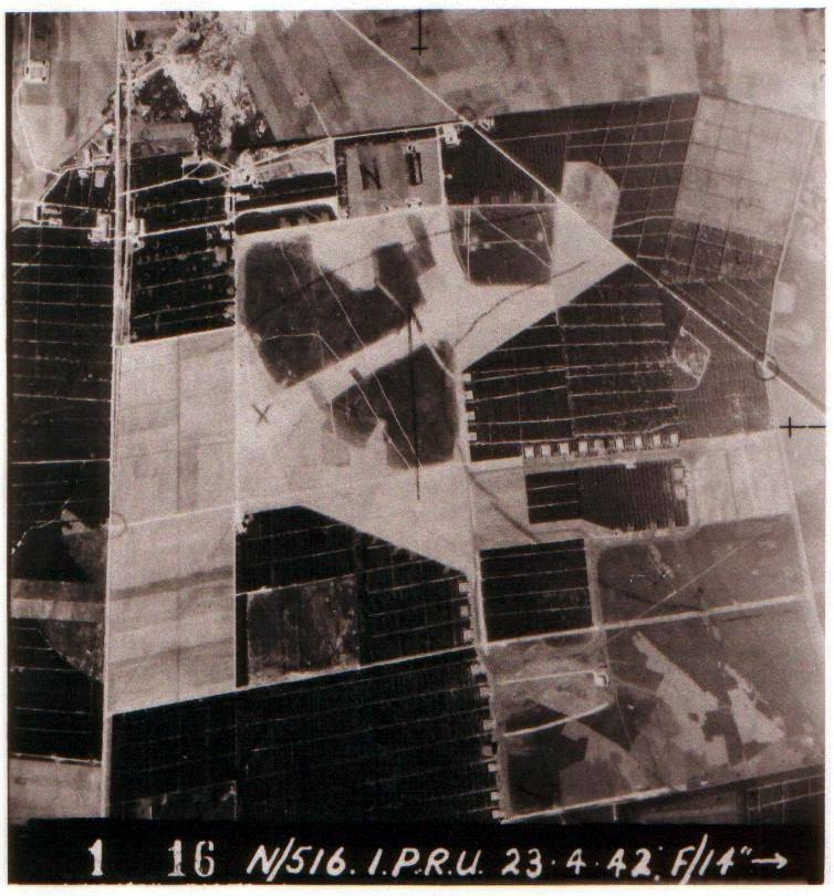
Rom airfield on an allied photograph shot in April 1942 (RAF, via lemvig.com).

Rom airfield on an allied photograph in 1944 (lw1944.flyfotoarkivet.dk).
Towards the end and immediately after the war the airfield was used as a refugee camp for displaced persons. As a direct result of an order by Hitler Germany and Denmark were to make room for refugees from East Prussia. They fled by the thousands for the coming of Soviet troops, many of them over the Baltic Sea. After the war the airfield housed about 11,000 refugees behind barbed wire, making it the third largest town in the county. Much of the area was subsequently designated for agricultural and other uses.
In the 1960s the former Einsatzhafen began seeing use by sports aircraft and later also by gliders. In the spring of 1974 a new runway (08/26 - 742x30meters - grass) was built for the public airfield that became known as Lemvig airfield (ICAO: EKLV). Much of the old Einsatzhafen still remains though, most of them being bunkers. To the southwest of the airfield three field hangars (dispersals really) and concrete taxiways can be found in the woods.

The above map on a Google Earth photo from 2006.
White ovals are areas with bunkers
blue lines indicate the current runway
red lines indicate the approximate whereabouts of the WW-II runway
purple indicates the dummy airfield.

Some taxiways can still be found in the woods south of the airfield (krigsturist.dk).
 Rom
Rom