Scenery Packages
11,447 files
-
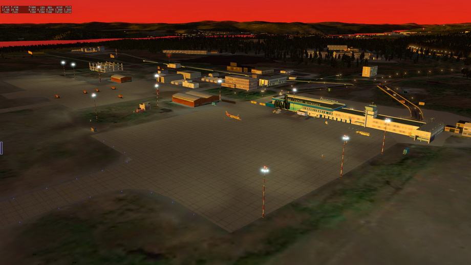
ULMM Murmansk Airport
By chrisru
Murmansk Airport is the international airport of Murmansk,Russia. It is located near the town of Murmashi in Murmansk's southern suburbs, 24 kilometres (15 mi) outside the city centre.
The airport served 276,599 passengers in 2006. It had its peak in 2004, when it received 303,432 passengers, which includes domestic operations and international routes to Norway and Finland.
This scenery ready for flying in VATSIM and IVAO networks.
For normal working need opensceneryx, russian scenery, ff_library.
Have a nice fly! Enjoy Russian North!
2,028 downloads
-
ULLL scenery
By Isch
ULLL scenery converted from MSFS "ULLL project", http://ulll.nm.ru
102 downloads
-

ULLI Saint Petersburg - Pulkovo
By Renair2
St. Petersburg, Russia
IMPORTANT: NOT 100% FINISHED. TAXI EDGE LIGHTING AND SOME ADDITIONAL OBJECTS BEING ADDED IN V2
Spent 6 hours today working on this. A new Russian Airport. Thanks to all of the amazing creators who made objects and libraries as otherwise this would not have been possible.
REQUIRES:
BS2001
THE HANDY OBJECT LIBRARY
FJS LIBRARY
MISTERX LIBRARY
NAPS LIBRARY
OPENSCENERY
RUSCENERY
RE_LIBRARY
If you do not already have the libraries used in this package, you may find download links in the Master Library List.
If you have issues, PM me as I don't always get to read the comments, make sure you have the most up-to-date libraries installed.
4,257 downloads
-

russia ULLI Pulkovo
By leroy29
Pulkovo (ULLI) is a russian international airport serving the city of Saint Petersburg.
The airport has two paved runways : 10L-28R (3397m) and 10R-28L (3397x45m).
ILS are available on runways 10L (110.5 MHz), 10R (111.9 MHz), 28L (108.9 MHz) and 28R (111.3 MHz)
Some charts are included in the zip file.
This scenery was created with custom made terminals based on satellite pictures, including the control tower advertising, signs in russian and night textures.
Thanks to myb who put the scenery on the gateway, which was taken for basis, and Litjan for improvements.
The autogates 102A 103A 103B 104A 104B 105A 105B 106A 106B 107A 107B 108A 108B 109A 109B are functional provided you installed the plugin "autogate". I also recommend to install the plugins "SAM" and SAM suite.
Installation : put the directory "ULLI Pulkovo" in your custom scenery directory.
Tested with Simheaven Europe V5.5 and X Plane 11.55r2.
The following libraries are needed (https://forums.x-plane.org/index.php?/files/category/165-libraries-for-scenery/ ) :
Openscenery
3D people
Mister_x
CDB
handy objects
ru_scenery
BS2001
2,027 downloads
-

Ülenurme Airport
By Ascenseur
Ülenurme Airport/ Tartu Airport is an airport in Estonia
You require these libraries
RE_Library
CDB_Library
OpenScenery X
71 downloads
(0 reviews)0 comments
Updated
-
ULAM - Naryan-Mar
By chrisru
For a long time we did not fly in the Arctic! And this section is not filled with us enough! Isn’t it time to eliminate this injustice ?! We present to you our new port - Naryan-Mar!
Naryan-Mar (nen. Naryana mar, “Red City”) is a city in Russia, the administrative center and the only city in the Nenets Autonomous Okrug. The city is located beyond the Arctic Circle, located in the lower reaches of the Pechora River, 110 km from the Barents Sea.
The distance from Moscow to Naryan-Mar is 1501 km, from Arkhangelsk to Naryan-Mar - 660 km. The nearest railway station - Usinsk - is located at a distance of 350 km, you can get to it by land only by winter road (winter road). In the summer, passenger boats run from Naryan-Mar to Ust-Tsilma.
Naryan-Mar is a federal airport of the city of the same name in the Nenets Autonomous Okrug. The operator of the airport is the open joint-stock company Naryan-Mar United Squadron.
It is a joint airfield. Belongs to the Ministry of Defense of the Russian Federation. The civil sector owns the apron, taxiways, parking lots. Class B airfield is equipped with a landing system of category II and III from both directions and light-signaling equipment. The classification number of runways (PCN) is 17 / R / B / X / T .. In addition to the main runway from reinforced concrete slabs, there are two intersecting unpaved runways for An-2 aircraft and helipads.
We wish you a pleasant flight!
401 downloads
(2 reviews)0 comments
Submitted
-
ULAA Arkhangelsk
By chrisru
My friends, if this goes on by the end of May, you will have more sceneries waiting for you !!! 🙂
In the meantime! We are pleased to introduce you to our other port - Arkhangelsk!
The original name of Talagi was carried by two farms and a small village located in the Solombala volost of the Arkhangelsk district of the Arkhangelsk province.
Talagi airfield was built in the summer of 1942 under the leadership of the representative of GKO Ivan Dmitrievich Papanin as a military airfield with a runway covering of wooden gratings filled with gravel.
Used as a civilian airport since 1963. The first types of aircraft that began to operate flights from the airport were Li-2, Il-14, An-24, Il-18 and Yak-40.
At the airport, from July 27, 1953 to July 1, 1960, the 878th Kalinkovichi Fighter Aviation Order of the Suvorov Regiment was stationed on the MiG-15 and MiG-17 aircraft before its disbandment
518th Fighter Aviation Berlin Order of the Suvorov Regiment (military unit 42192), which was part of the 10th separate air defense army (Arkhangelsk air defense army). In October 1966, the 518th IAP was the first in the Air Defense Forces to adopt the Tu-128; in the 1980s, the regiment was rearmament on MiG-31 aircraft. In 1998, 518 IAP was disbanded.
On June 22, 1999, the MiG-31 aircraft was put into eternal parking in memory of the regiment in the Talazh air town.
Since 1998, the 89th separate aviation unit of the 21st Air Defense Corps has been based at the airport. From 2014 to the present, a separate transport mixed aviation regiment of the Western Military District was transferred to the composition. As part of 2 Mi-8MTV-5 and 2 An-26.
Since November 2009, the airport has received admission to receive and send Airbus A319 and Airbus A320.
We wish you a pleasant flight!
For support, I want to thank Sunagatuli Igor, Shestakov Denis, Nikolay Gorbatenko and the unknown sender, unfortunately there is no data with the name. We are very grateful to you, my friends! Thank! It is you who help this project pay for your usual needs such as communications and electricity, as well as buy spare parts and even upgrade a little server, which works by giving you our scenes! Thank!
Sorry for, but download uses ftp server with anonymous login and any password. Please use third patty download application if your web browser can't download scenery from FTP correctly.
1,339 downloads
-

UKSH-Lübeck-Universitätsklinikum Schleswig-Holstein
By oliwer112
Moin hier Ist mein erstes Krankenhaus was in 3 Tagen gebaut wurde
es handelte sich um ein Original Bau der UKSH Lübeck mit original Texturen
ich Bedanke mich bei ein Kollegen für die Strobe und die LIT Textur das er die gemacht hast
das krankenhaus darf nicht auf Andaren seiten hochgeladen werden
Verbesserungswünsche kannst du gerne in die Kommentare schreiben und die euch ist gefällt
wenn ihr könnt ihr gerne mir auch auf Instagram: https://www.instagram.com/xplane_11_rettungspilot/
da könnt ihr euch gerne melden
es werden folgende Bibliothek verwendet
hello here is my first hospital which was built in 3 days
it was an original building of the UKSH Lübeck with original textures
I thank a colleague for the strobe and the LIT texture that he made
the hospital may not be uploaded to Andaren pages
You can write improvement requests in the comments and you like it
if you can feel free to me on Instagram: https://www.instagram.com/xplane_11_rettungspilot/
you are welcome to contact us
the following library is used
flyagi-Bibliothek
168 downloads
-

Ukraine roads
By Alex Krug
Converted from openstreetmaps database roads of all Ukraine.
89 downloads
-

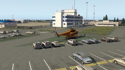
UKON - Mykolaiv International Airport - Ukraine
By Vega66
Brief context
Mykolaiv International Airport, (Ukrainian: Міжнародний аеропорт Миколаїв) near the city of Mykolaiv, or Nikolaev in Russian. it is one of the largest and most technically equipped airports in the South of Ukraine, offering a 8383x144 ft (2555x44 m) asphalt runway.
The airport is capable of receive aircrafts with landing weight up to 220 tonnes, including parking places for up to 8 IL-76 cargo jets and commercial aircrafts as large as the Airbus A310.
It performed regular commercial flights up to 2011, after which it saw a long period of inactivity. Now it has plans to resume regular commercial flights, with some routes already starting to be established by Windrose airlines and SkyUp.
About this scenery
This is my first scenery attempt ever, so every comment or suggestions are highly appreciated. I did it because I haven't found any sceneries available on the community for this airport and also because I have a close connection to this city. It is a somewhat "romantic" approach, not 100% faithful to the real premises. I tried to catch the light of the location and add some personal artistic details (e.g the choice for the High Tower) to provide a nice visual mood on approach, in contrast of the dull feeling of landing on an naked scenery. However, effort was employed in placing most of the artifacts according to the available imagery for the site, and represent the main technical details as accurate as possible.
The main terminal is not an accurate depiction as I wanted to, sadly my actual design skills and available time don't allow a more realistic approach for this aspect as I would like. If anyone out there having those kind of will and talent wishes to improve this, or any other aspect, by all means do it, it will be most welcome and appreciated.
The ramps are placed as correctly as possible, considering the data present on my available charts.
Installation
Just unzip the file and place it directly on the Custom Scenery folder. In your scenery_packs.ini file, make sure that the "Airport UKON Mykolaiv V2.01" folder is placed before default airports, libraries, landmarks or orthos.
Required Libraries
Library 3D_people_library
Library ALES_DEV_LIB
Library CDB-Library
Library handyobjects
Library HungaryVFR-Library
Library JB_Library
Library MisterX_Library
Library RescueX
Library ruscenery
Ortho imagery is not provided, however I strongly recommend to complement it with Ortho4XP Tile +47+031 (nice results with Arc or BI sources, ZL16+ minimum)
849 downloads
-

UKLR_2 Rivne
By vdfishev
Airport Rivne, Ukraine. Made for own use, but maybe someone will need ...
Libraries used the most popular and commonly available: https://forums.x-plane.org/index.php?/forums/topic/90776-master-list-of-libraries/
209 downloads
-

UKLO Kolomyia Air Base XP11
By simbambim
Kolomyia Air Base is a military airfield in Ivano-Frankivsk Oblast, Ukraine.
Made from scratch, this is a modified version of the one I submitted to gateway.
For the XP12 version click here.
To install, unzip into Custom Scenery folder. Required libraries:
CDB-Library: https://forums.x-plane.org/index.php?/files/file/27907-cdb-library/
OpenSceneryX: https://forums.x-plane.org/index.php?/files/file/2226-opensceneryx/
RuScenery: https://ruscenery.x-air.ru/
73 downloads
(0 reviews)0 comments
Submitted
-

UKLN Chernivtsi International Airport
By pyreegue
Chernivtsi International Airport for X-Plane 10/11 (Tested in XP11.02r1). The airport is located on the southwest of Ukraine in the city of Chernivtsi. It has a runway length of 2300m and an ILS CAT-I.
Recently the one and only runway had a quick repair, having its central part covered with a fresh layer of asphalt. WARNING! Make sure you have disabled the "Runways follow terrain contours" in order to avoid large hills on the apron. (Just a bad DSF for that region)
Authors: Viacheslav Pyrih [email protected] Mikhail Gusev (Terminal textures rendering) This scenery requires additional libraries: CDB Library ruscenery Library MisterX Library The Handy Objects Library OpenSceneryX Library Further info can be found in the Readme file. Welcome to Ukraine, folks1,265 downloads
-

UKLH Khmelnytskyi Airport
By EDGE95
Khmelnytskyi Airport in it's best years was one of the biggest airports in Western Ukraine. It had status of international airport and operated a number of flights from different countries.
Airport was able to handle all aircrafts up to 61.000 kgs.
But in the early 2010s, all flights were stopped and aerodrome was closed.
Nowadays, in 2020, it is used only by general aviation, but there are plans for it's reconstruction.
If they come true, the scenery would be updated
Required libraries:
MisterX6 Library ver 1.5 and higher
Ruscenery
pm_library
R2_Library
OpenSceneryX
141 downloads
(0 reviews)0 comments
Updated
-

Ukhta Complexe scenary
By Oleg_Tr
Релиз комплексной сцены Ухты для X-Plane 11
Однажды, задумав большое путешествие на Восток, обратил внимание на фактическое отсутствие сценария для X-Plane Ухты.
Тот, что представлен в группе — конвертированная сцена из девятой версии MS Flight Simulator. Однако, он требовал не просто серьезной доработки, а фактической переделки.
В основу задуманного сценария лег фототеррейн, созданный отдельно для города и отдельно для аэропорта. Примерив городскую застройку из конвертированного сценария, наложив сверху собственный ОСМ Северо-западного федерального округа, обратил внимание на очень хорошее совпадение объектов исходной сцены с автогеном.
Очень сложной задачей оказалось сохранение 3D-моделей зданий и инфраструктуры реального аэропорта, созданные уважаемым Braniff-ом. Я обращался к нему с запросом разрешения на использование его объектов, но он мне так и не ответил.
Из проблем конверта, в первую очередь, — ВПП была неправильно расположена и ориентирована на местности изначально. А это за собой потянуло всю сцену. При этом совпадение фототеррейна с ОСМ-автогеном очень близкое.
Сложность задачи сохранения оригинальных объектов состояла в том, что в один obj-файл объединялись различные части зданий и сооружений, разбросанных по всей площади аэропорта. Это могли быть стены, крыши, фонари и т.п. По этой причине, в конвертированных сценариях очень часто встречаются объекты, висящие в воздухе. Стены собирались с крышами, с антеннами и габаритными фонарями в WED. Просвященные меня поймут правильно. )))
По этой же причине, от оригинальных статических обьектов, от рулежек, разметки и проч., пришлось отказаться, заменив их аналогами из библиотек или перерисовав их заново. Рулежки были откорректированы в соответствии с имеющимися снимками. Было добавлено освещение аэропорта.
Аэропорт находится в зеленой зоне, пришлось засадить территории, прилегающие к аэропорту зелеными насаждениями в соответствии со снимками из космоса. Прилегающая зона к аэровокзалу тоже зрительно выбивалась по стилю. Поэтому автоген на территории, прилегающий к аэровокзалу был заменен на кастом. Сложность была в том, что надо было сохранить так же и транспортную инфраструктуру.
После того, как сцена была закончена, я ее передал на проверку в x-flight.su на тестирование. Ребятам из x-flight огромное спасибо за тестирование и исправление найденных неточностей. Добавив зимний фототеррейн, они тем самым, улучшили комплексный сценарий Ухты, сделав его сезонным. Зимний фототеррейн можно скачать отсюда: http://www.x-flight.su/downloads/ukhta/UUYH_winter.zip.
Для корректного отображения сценария Ухты должна быть в обязательном порядке установлена библиотека ruscenery. Z_Ukhta City должна быть расположена ниже ортофотографий в scenery_packs.ini. ОСМ Северо-западного федерального округа так же желательно должен быть установлен. В scenery_packs.ini располагается ниже Global airports (London Landmarks от версии 11.10 и выше) и выше библиотек. Для корректной работы ОСМ необходима библиотека world models.
Для распаковки архивных файлов использовать архиватор 7ZIP.
Желаю удачных полетов.
Oleg_Tr (Олег Тронов, Сочи)
-----------------------------------
Release of the complex scene of Ukhta for X-Plane 11 only
One day, having decided a lot of traveling in the East of Russia, drew attention to the virtual absence of the X-plane scenery for Ukhta. About this city you can here: https://en.wikipedia.org/wiki/Ukhta
The scenery, converted from the MS Flight Simulator 2004 required an actual rework.
The scenery was based on a phototerrain, created separately for the city and separately for the airport. Having tried the urban development from the converted scenario, having superimposed on its own OSM of the North-West Federal District, drew attention to a very good coincidence of the objects of the original scene with the autogen.
The airport is in the green zone, it was necessary to plant the territories adjacent to the airport with green spaces in accordance with the images from space. The adjoining zone to the airport terminal also visually beat out in style. Therefore, the autogen on the territory adjacent to the terminal was replaced by a custom one. The difficulty was that it was necessary to maintain the same transport infrastructure.
After the scene was finished, I sent it for testing in x-flight.su for testing. Guys from x-flight thank you so much for testing and correcting the inaccuracies found. Adding a winter phototerrain, they thereby improved the complex scenario of Ukhta, making it seasonal. Winter phototerrain you can download from here: http://www.x-flight.su/downloads/ukhta/UUYH_winter.zip.
Author of the custom 3D-models -- respectable Braniff. Many thanks to him.
For the correct display of the Ukhta scenario, the ruscenery library must be installed. Z_Ukhta City should be located below the libraries in scenery_packs.ini. The OSM of the North-West Federal District is also desirable to be established. In scenery_packs.ini is located below the Global Airports (London Landmarks from version 11.10 and above) and above the libraries. To work correctly, OSM requires the World models library.
Attention: for unpack archive files use 7ZIP only. All files checked and not corrupted. 7zip you can download from here: http://www.7-zip.org/
Good luck!
Oleg_Tr (Oleg Tronov, Sochi, Russia)
----------------------------------------
2,001 downloads
-

UKFB Belbek (Sevastopol)
By HardHuman
This is medium airport, using by Air Forces and Civilian aircrafts, Placing on coast of Black Sea providing nice approach. Scenery required Ruscenery and OpensceneryX. File earth_nav should be placed in resources/default data with change.
287 downloads
- UKFB
- Sevastopol
- (and 1 more)
-

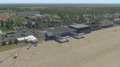
UKBB Kiev Boryspil Airport
By relicroy
Ukraine.
UKBB - Kiev Boryspil Airport Kiev Boryspil Airport is the home airport for Ukraine International Airlines located near the town of Boryspil and some 30km from the city centre Tested in X Plane v10.41 on a PC Requires the following files: 3D people library 3.8
CDB Library
The Handy objects library 3.9
Flags of the world
FFlibrary
MisterX Library
NAPS_Library
OpensceneryX
R2_library
RE_Library
ruScenery
If you do not already have the libraries used in this package, you may find download links in the Master Library List: http://forums.x-plan...showtopic=90776
Video : https://www.youtube.com/watch?v=0mvnOxh9Z-I&feature=youtu.be
943 downloads
-

UKBB Boryspil Intl Airport Ukraine
By tdg
UKBB Boryspil Intl Airport Ukraine 29 kilometers from the capital of Kiev. Many hours put in to this airport, enjoy.
Great objects by FlybyGuy & Einstein that gives airports a great looking effect, please remember to leave them feedback and stars.
Requires OpensceneryX, R2_library, ruScenery, FFlibrary, Flags of the World, The Handy Objects Library 2.1 & RE_Library - airport buildings and related objects 1.3 installed to run.
Made on a windows 7 PC 64bit Xplane 10.30
3,470 downloads
-

UKBB - Kyiv Boryspil International Airport
By Ted_Stricker
This scenery was originally created by Intersky Studio, and later converted to X-Plane by Timur Lenk. And I would like to express my deep gratitude to them for the work done, because this scenario is the most complete, accurate and best recreation of the UKBB airport for X-Plane!
Boryspil International Airport (Ukrainian: Міжнародний аеропорт «Бориспіль») (IATA: KBP, ICAO: UKBB) is an international airport in Boryspil, 29 km (18 mi) east of Kyiv, the capital of Ukraine. It is the country's largest airport, serving 65% of its passenger air traffic, including all its intercontinental flights and a majority of international flights. It is one of two passenger airports that serve Kyiv along with the smaller Zhulyany Airport. Boryspil International Airport is a member of Airports Council International.
This scenery tested on X-Plane 11 only, I have no idea if it works on earlier versions.
You will need to have follow libraries:
1. Ruscenery
2. RA_library
3. ALES Developer Library 1.0.1
4. Hard Surface
+ To get working gates at Terminal D, you need to have SAM Plugin installed.
Enjoy the main and biggest airport of Ukraine!
P.S. If you don't have "Hard Surface" library. It's attached.
ZZ_DF-Hard_Surface.zip
8,732 downloads
-

UKBB - Boryspil International Airport
By XPlanePort
UKBB - Boryspil International Airport
Boryspil International Airport (IATA: KBP, ICAO: UKBB) is an international airport in Boryspil, 29 km (18 mi) east of Kiev, the capital of Ukraine. It is the country's largest airport, serving 65% of its passenger air traffic, including all its intercontinental flights and a majority of international flights.
I dedicate this work to my father. He passed away in 2010. Although he dearly loved Ukraine, in 1995 he moved his family to the United States, to give us a better life. He succeeded, and I am truly grateful for that!
Before he passed away, he traveled to Ukraine every summer (KIAD – EHAM or EDDF – UKBB).
I love you Dad, and I miss you so much.
The airport scenery is now uploaded to the X-Plane Scenery Getaway and awaits approval to be part of default X-Plane.
There are more things that I would like to do to the scenery, but I feel that it is at the point where I can share my work with everyone, and then, continue the work to improve the airport even further:
- Work on more detailed buildings using the new Terminal Kit (one can do crazy detailed buildings with the kit, but it takes time to do it right and to the standard I have in mind).
- Add more buildings.
- Add more service vehicles and refine vehicles starts and destinations
- Add more lights (to parking lots, local roads, etc.). I need to get more pictures since it is hard to see things on the best resolution satellite photos available at the moment.
- I can think of many things that still can be improved…
Please enjoy, and if you see something that needs to be corrected/added, please let me know!
Watch out for crazy Ferrari, Limo and Crew Car drivers, I don’t think they stop at pedestrian crossings.
P.S. I also fine-tuned local NAVAIDs (LOC, GS, OM, MM), after carefully verifying all the runway alignments.
You change all LOC, GS, OM, MM values for UKBB to the following in your “X-Plane 11/Custom Data/user_nav.dat” file:
Please refer to the following document if you need additional details:
https://developer.x-plane.com/?article=navdata-in-x-plane-11
4 50.316381847 030.903241590 421 11130 18 182.680 IBI UKBB UK 18L ILS-cat-I
4 50.312083289 030.878699872 417 10890 18 182.650 IKB UKBB UK 18R ILS-cat-I
4 50.362138541 030.882332279 418 11050 18 2.650 IKE UKBB UK 36L ILS-cat-I
4 50.367452977 030.906982498 421 10970 18 2.680 INO UKBB UK 36R ILS-cat-III
6 50.357812916 030.904448860 421 11130 10 300177.000 IBI UKBB UK 18L GS
6 50.349423474 030.878888900 421 10890 10 300183.000 IKB UKBB UK 18R GS
6 50.323523145 030.876995137 421 11050 10 300357.000 IKE UKBB UK 36L GS
6 50.327472200 030.902222200 421 10970 10 300357.000 INO UKBB UK 36R GS
7 50.397443676 030.909179281 389 0 0 182.680 IBI UKBB UK 18L OM
7 50.386388807 030.884092004 405 0 0 182.650 IKB UKBB UK 18R OM
7 50.282861341 030.876579334 360 0 0 2.650 IKE UKBB UK 36L OM
7 50.287516913 030.901127266 383 0 0 2.680 INO UKBB UK 36R OM
8 50.368880074 030.907087028 421 0 0 182.680 IBI UKBB UK 18L MM
8 50.362666873 030.882370569 418 0 0 182.650 IKB UKBB UK 18R MM
8 50.311666449 030.878669625 417 0 0 2.650 IKE UKBB UK 36L MM
8 50.315737539 030.903194396 421 0 0 2.680 INO UKBB UK 36R MM
I will submit “A NAVAID” report to https://gateway.x-plane.com/bugs so that UKBB NAVAIDs values can be changed to the above (if and when my airport will be approved for and will be included in the default X-Plane) and be distributed to everyone during the X-Plane future update.
UKBB Charts:
https://www.rocketroute.com/airports/europe-eu/ukraine-ua/plates-boryspilinternationalairport-ukbb.html
I worked hard on this one Enjoy! Still working to add more details…
Слава Україні!
3,231 downloads
- ukraine
- boryspil international airport
- (and 1 more)
-

UK, North of England landmarks, XP8.6+-XP9.0+
By sigoo
Here’s a package I’ve been meaning to upload for a while. A conversion of Geoff Smith’s North England landmarks, posted with his permission.
Should be good for XP8.6+ and XP9.0+.
Contains the following landmarks :
1. Whitby - Pier, Abbey and St Marys church, Boulby Mine
2. York - York Minster
3. Middlesbrough - Transporter Bridge, Riverside Stadium, ICI, Power station and various industrial buildings
4. Newcastle - Angel of the North and nearby buildings, Tyneside cranes
5. South Shields - Souter Lighthouse
6. Whitley Bay - St Mary's Lighthouse
7. Flamborough Head - Lighthouse and tower
8. Manchester - Jodrel Bank Radio Telescope
9. North Yorkshire - Bilsdale Transmitter
10. Durham - Cathedral
The Emley Moor TV transmitter close to Huddersfield, originally in this package, was removed since it can be found in the UK-Obj-Emley_Moor package. This additional package also contains a number of other antennas and other telecommunication landmarks in the north of England.
The models can be found by getting airborne at the following airports:
• Durham Tees Valley - for Teeside, transporter etc then head to coast and fly south approx 15 miles for Boulby Mine and Whitby then further on down to Flamborough.
• Newcastle - South for Durham Cathedral - East for Tyneside Cranes then head to coast for Souter Lighthouse and St Mary's Isle lighthouse.
• Rufforth York - for York Minster.
• Manchester - Jodrel Bank Radio Telescope should be visible from the runway.
837 downloads
-

UK_EGCN_Doncaster.zip XPlane 8.32 and above
By sigoo
Robin Hood airport is situated on the ex-airforce base of RAF Finningley close to Doncaster in South Yorkshire, UK. The airport now serves South Yorkshire with lots of traffic from charter holiday flights and budget airlines. You can see the old airbase buildings behind and to the right of the terminal as you face it from the runway. Doncaster lays at the edge of what was once Sherwood Forest, the home of the folklore hero Robin Hood, hence the name.
This scenery is a conversion from the freeware MSFS2004 package by John Young. The conversion and posting of this package were done with the consent of the original author.
As my first foray into X-plane scenery, I hope some of you will enjoy this.
144 downloads
-

UK Southwest Lighthouses -Update
By xplaneuser
Hello All, this is a minor update which corrected some lighthouses into the right place.
For the UK Scenery Project here comes the southwest lighthouses from Devon and Cornwall. They are nice landmarks in South West England and good fun to find them out there. Read the original author Nick readme file how to find them or fly along the coast from Plymouth to Lundy.
I wrote Nick and asked him for his authorization to upload the converted file. This is, what he wrote:
Cool
permission granted
nick
Thanks Nick rolleyes.gif
Now enjoy
Christian
PS: I always get very positive response on my requests to upload converted sceneries. I encourage everybody who has a good converted scenery for private use, get in touch with the original authors and ask them to give their authorization to upload them.
324 downloads
-

UK Refineries
This is a conversion of Gerry Winskill's refineries that he produced for FS2004 along with his ANO files. He has granted me permission to convert his work and distribute freely to the Xplane community. Unfortunately due to the limitations of Xplane 10 there are no smoke animations.
Install in the usual manner. Enjoy
Coverage
--------
Milford Haven Area
------------------
Amoco
Gulf
Texaco
All can be seen, when on an 8 mile finals to Haverfordwset's Rwy 03.
Cheshire
--------
Stanlow
Visible from the ground, at Liverpool Airport.
North Eastern England
---------------------
P.I.P.
Wilton
Billingham
Seals Sands
All visible, from the circuit, at Teesside Airport.
Humberside
----------
Lindsey
Conoco
Salt End
Clearly visible when landing or taking of, from Humberside Airport.
Essex
-----
Coryton
The approach to London City's Rwy 28 crosses the refinery.
Hampshire
---------
Fawley
Visible, when on finals to Southampton Airport's Rwy 02.
509 downloads
-

UK Oil Fields
Scotland, England, Ireland and Wales, UK
Hello rotor heads! If like me you enjoy flying helicopters in remote places, I really hope you can enjoy and appreciate this scenery add on. I have pulled together a collection of oilfields in the UK covering the East and West of Shetland, Central and Southern North Sea as well as those installations in Liverpool Bay on the West coast. There are 203 offshore locations in total and each has a ramp start so you can set off from the platform or alternatively you will also see 6 onshore hot spots. These are :
H1 Scatsta (EGPM) - Servicing East Shetland Basin locations.
H2 Aberdeen (EGPD) - Servicing Central North Sea locations, and UK helicopter operational hub.
H3 Sumburgh (EGPB) - Servicing West of Shetland locations.
H4 Humberside (EGNJ) - Servicing Southern North Sea locations.
H5 Norwich (EGSH) - Servicing Southern North Sea locations.
H6 Blackpool (EGNH) - Servicing Liverpool Bay and Irish Sea locations.
These should work without any conflicts with other custom scenery (see screenshots), and to get the onshore images you will need the custom scenery created by others.
When you open X-Plane, enter XOILUK and you will see the scenery come up. Start it and the go to Location, select Global Airport and select the starting point you wish to use. Scatsta will be the default.
If you look around you will find the occasional tanker being loaded or supply boats dropping of supplies to one or two of the platforms so happy hunting. There is also an emergency situation going on East of Aberdeen, so fire up your Sea King and fly out to 57.868, -0.360 (57.52.6 N, 0.21.37 W) and let me know what you find. Hopefully you make it in time to save all the souls on board as the North Sea is pretty cold even in the summer.
When flying out to an installation this is typically at 3,000ft and when flying to shore this is typically at 2,000ft. Between installations this is typically between 500 and 1,000ft.
The map found via the link below will hopefully show you where everything is in relation to each other and I hope it works OK for you. I have also include a WED snapshot in the screen shots which gives a high level over view of the various locations. Looks like a "fix the ball coupon"... now I am showing my age....
https://www.gov.uk/government/uploads/system/uploads/attachment_data/file/534400/UKCS_Offshore_Infrastructure.pdf
The link below also gives further details on various helideck locations. Go to Certificates, then select the area you want, UK-N, UK-S, UK-W pick the platform and then the plate. Should help with navigation to each location. Be aware the deck heights are not reflected in the scenery at this stage.
http://www.helidecks.org/
Here is also a handy wee tool to calculate the bearing and distance between points. Helpful for flight planning purposes.
http://www.sunearthtools.com/tools/distance.php
The scenery has been made using WED on my PC running Windows 8.1 Pro and also X-Plane 10.45 with the HDMesh V3 installed. For the scenery to work, you will need the latest version of the Handy Objects Library (5.4), as well as OpenSceneryX, and I also have used 2 or 3 of the fabulous 3D people from the late dkm.
If you do not already have the libraries used in this package, you may find download links in the Master Library List.
If you have latest version of the above libraries you should be good to go, so to install the scenery, download the file, unzip the folder and place directly into your main Custom Scenery folder.
As of version 1.3 you will also find an Excel file in a folder called Documents. This contains a list of all the platforms and their decimal latitude and longitude co ordinates to aid with navigation. It also now includes information on the heights of the various helidecks.
I really hope you like the details and if you encounter any issues or problems please let me know and I will do what I can to fix them.
As always, constructive comments and feedback always welcome, and if you do decide to download XOILUK please take a moment to click on the voting stars. It means a lot to get good feedback.
1,945 downloads