Pajuostis Air Base
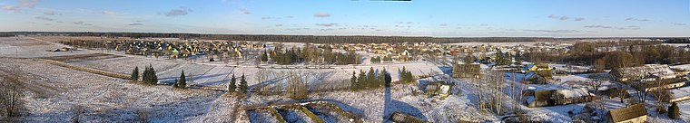
Panevėžys Air Base is an air base in Lithuania located 6 km east of Panevėžys. It is a transport base, with a very large ring taxiway 2 km in diameter.Localities in the Area

Pajuostis Air Base
- Type: Aerodrome
- Description: airport in Lithuania
- Categories: air base and transportation
- Location: Velžio sen., Panevėžys District Municipality, Panevėžys County, Lithuania, Baltic states, Europe
- View on OpenStreetMap
Latitude
55.7302° or 55° 43' 49" northLongitude
24.46245° or 24° 27' 45" eastElevation
57 metres (187 feet)IATA airport code
PNVICAO airport code
EYPPOpen Location Code
9G76PFJ6+3XOpenStreetMap ID
node 410249446OpenStreetMap Feature
aeroway=aerodromeGeoNames ID
596129Wikidata ID
Q5732371Pajuostis Air Base Satellite Map
© OpenStreetMap, Mapbox and Maxar
Also Known As
- Cebuano: Pajuostis Air Base
- English: EYPP
- English: PNV
- English: Pajuostis Airport
- English: Panevėžys Air Base
- English: Tulpe Air Base
- Indonesian: EYPP
- Indonesian: PNV
- Japanese: パネヴェジース空軍基地
- Lithuanian: Lietuvos kariuomenės Karinių oro pajėgų Antroji aviacijos bazė
- Lithuanian: Pajuosčio aerodromas
- Malay: Lapangan Terbang Pajuostis
- Persian: پایگاه هوایی پنویژیس
- Polish: Baza lotnicza Poniewież-Pajuostis
- Swedish: Pajuostis Air Base
- Swedish: Pajuostis flygbas
- Tajik: Пойгоҳи ҳавоии Паневезис
- Tajik: Пойгоҳи ҳавоӣ пнуижис
Localities in the Area
- BatrakaiVillage
- KaimiškisVillage
- KaršinaukaVillage
- BiliūnaiVillage
- TekoriškisVillage
Landmarks in the Area
- Žydų genocido aukų kapaiCemetery
- Kurganavos mokyklos stadionasStadium
- „Sport&Spa”Sports venue
- Panevėžio karo prievolės centrasGovernment office
- Liūdynės Lietuvos Nepriklausomybės kovų dalyvių kapinėsCemetery
Escape to a Random Place
Discover other destinations in the world.
About Mapcarta. Thanks to Mapbox for providing amazing maps. Data © OpenStreetMap contributors and available under the Open Database License. Text is available under the CC BY-SA 4.0 license, excluding photos, directions and the map. Description text is based on the Wikipdia page Pajuostis Air Base. Photo: Lestath, CC BY-SA 3.0.