
eCOPILOT
50+
Downloads

Everyone
info


About this app
eCOPILOT (The electronic Copilot) is a simple to use yet full-featured navigation (moving map), logbook and flight track recording app for private, recreational and ultralight pilots.
It is designed for use on 4.3 inch or bigger phones and tablets (recommended minimum screen size is 4.7 inches).
eCOPILOT is geared towards the VFR "recreational" private pilot that wants an easy to use navigation app that is free of extra "over-complicated" features and that provides a "single tap" logbook to keep track of flying times.
A User's Manual (pdf doc) is available at http://www.electroniccopilot.com
As a navigation app eCOPILOT offers:
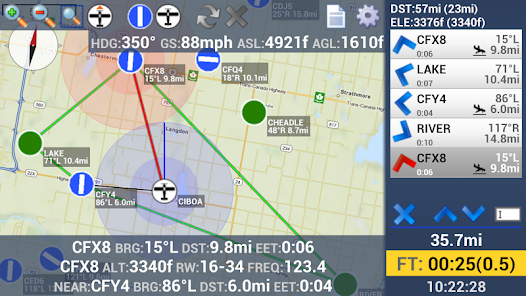
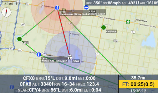
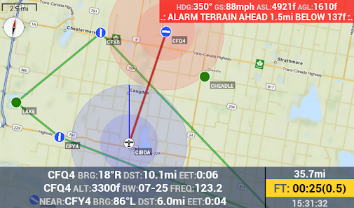
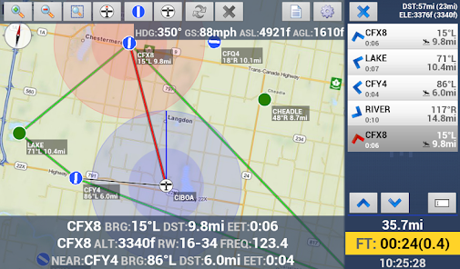
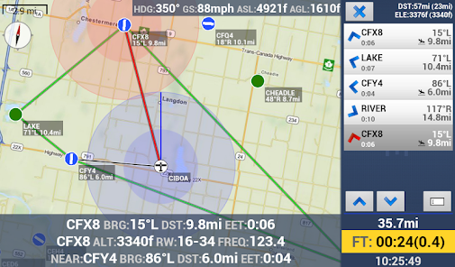
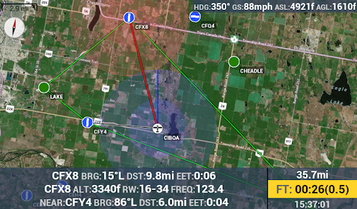
• Moving map navigation with worldwide airport database and user added Point of Interests.
• Canadian Airspaces with visual alarm if inside an airspace.
• Multi leg Flight Route creation with auto-selection of next leg POI/Airport.
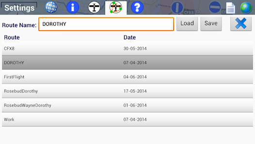
• Routes and added POIs may be saved for later use.
• Total Route Distance and Current Leg Distance. Current leg distance is calculated from the previous destination to the currently selected route destination.
• Route Highest Elevation and Current Leg Highest Elevation. Current leg elevation is calculated from the previous destination to the currently selected route destination.
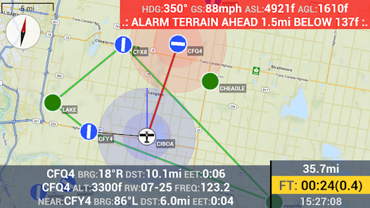
• Altitude Above Ground with Terrain Avoidance Alarm.
• Total Flight Time Alarm.
• Lines connecting all POIs/Airports in the route.
• Total Route Distance and current flown distance.
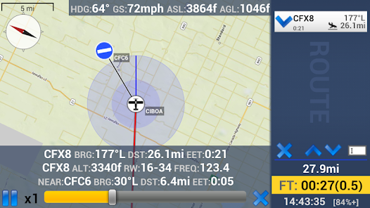
• Bearing, Distance and Estimated en-route time to next selected POI/Airport (with line connecting Aircraft to POI/Airport).
• Bearing, Distance and Estimated en-route time to all POI/Airports that are part of your flight route.
• Bearing, Distance and Estimated en-route time to nearest POI/Airport (with optional line connecting Aircraft to nearest POI/Airport).
• Configurable reference circle around aircraft and selected POI/Airport with line showing aircraft heading.
• Worldwide Airport database: Location, Runway heading, length, radio frequencies, altitude, description.
• Single Tap to go to nearest or any other POI/Airport.
• Single Tap to add POI/Airport to current flight leg.
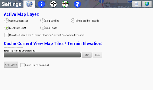
• Maps are cached on the device. No need for internet while flying. Four different free map layers to choose from (including Satellite and Road maps). All layers have world wide coverage.
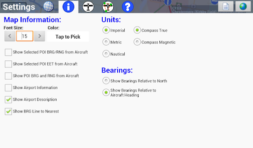
• Imperial, Nautical and Metric units.
• True and Magnetic compass.
• Full Screen Map View
As a logbook eCOPILOT includes:
• Single tap to start and stop the current logbook.
• Recording of flight track.
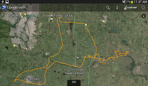
• Tracks may be "playback" within eCOPILOT. Up to 20x playback speed and "rewind" and "fast-forward" supported.
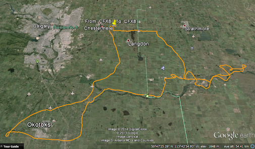
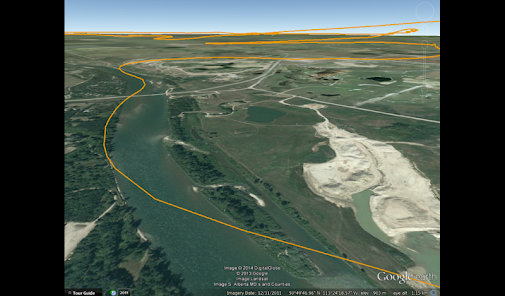
• Tracks may be viewed on any application, mobile or desktop, that supports KML files (such as Google Earth for Desktop / Android, MAPinr on Android, etc.)
• Logbook will automatically select "FROM" and "TO" airport/POI.
• Total Flight Time and current time display.
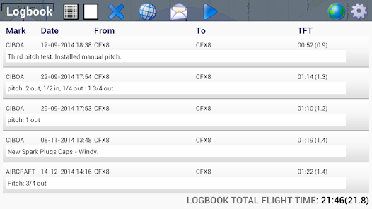
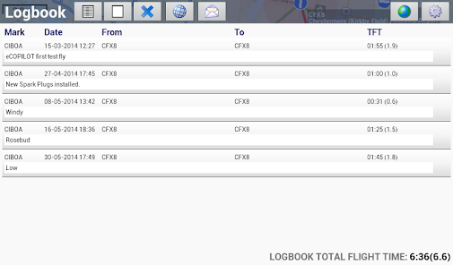
• Logbook entries can be viewed within the app.
• Logbook TFT and Air Time shown under the logbook entries list.
• Notes may be added to each Logbook entry.
• Logbook is saved as a plain text comma separated file that can be viewed on any text viewer app or imported in spread-sheet programs. Logbook entries contain: Aircraft Mark, From, To, Date/Time of take-off, Date/Time of landing, Total Flight Time as Hour/Minutes and Hours decimal, Total Travel Distance, Notes.
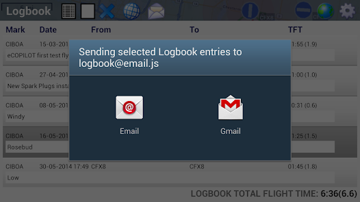
• Send logbook file and tracks to your email.
• Logbook and tracks may be copied directly from the tablet to your computer over the tablet USB connection.
Please report any issues or bugs to electroniccopilot@gmail.com (if reporting a crash please include as much information as you can about what you were doing with the app at the moment of the crash, app version, etc.).
It is designed for use on 4.3 inch or bigger phones and tablets (recommended minimum screen size is 4.7 inches).
eCOPILOT is geared towards the VFR "recreational" private pilot that wants an easy to use navigation app that is free of extra "over-complicated" features and that provides a "single tap" logbook to keep track of flying times.
A User's Manual (pdf doc) is available at http://www.electroniccopilot.com
As a navigation app eCOPILOT offers:
• Moving map navigation with worldwide airport database and user added Point of Interests.
• Canadian Airspaces with visual alarm if inside an airspace.
• Multi leg Flight Route creation with auto-selection of next leg POI/Airport.
• Routes and added POIs may be saved for later use.
• Total Route Distance and Current Leg Distance. Current leg distance is calculated from the previous destination to the currently selected route destination.
• Route Highest Elevation and Current Leg Highest Elevation. Current leg elevation is calculated from the previous destination to the currently selected route destination.
• Altitude Above Ground with Terrain Avoidance Alarm.
• Total Flight Time Alarm.
• Lines connecting all POIs/Airports in the route.
• Total Route Distance and current flown distance.
• Bearing, Distance and Estimated en-route time to next selected POI/Airport (with line connecting Aircraft to POI/Airport).
• Bearing, Distance and Estimated en-route time to all POI/Airports that are part of your flight route.
• Bearing, Distance and Estimated en-route time to nearest POI/Airport (with optional line connecting Aircraft to nearest POI/Airport).
• Configurable reference circle around aircraft and selected POI/Airport with line showing aircraft heading.
• Worldwide Airport database: Location, Runway heading, length, radio frequencies, altitude, description.
• Single Tap to go to nearest or any other POI/Airport.
• Single Tap to add POI/Airport to current flight leg.
• Maps are cached on the device. No need for internet while flying. Four different free map layers to choose from (including Satellite and Road maps). All layers have world wide coverage.
• Imperial, Nautical and Metric units.
• True and Magnetic compass.
• Full Screen Map View
As a logbook eCOPILOT includes:
• Single tap to start and stop the current logbook.
• Recording of flight track.
• Tracks may be "playback" within eCOPILOT. Up to 20x playback speed and "rewind" and "fast-forward" supported.
• Tracks may be viewed on any application, mobile or desktop, that supports KML files (such as Google Earth for Desktop / Android, MAPinr on Android, etc.)
• Logbook will automatically select "FROM" and "TO" airport/POI.
• Total Flight Time and current time display.
• Logbook entries can be viewed within the app.
• Logbook TFT and Air Time shown under the logbook entries list.
• Notes may be added to each Logbook entry.
• Logbook is saved as a plain text comma separated file that can be viewed on any text viewer app or imported in spread-sheet programs. Logbook entries contain: Aircraft Mark, From, To, Date/Time of take-off, Date/Time of landing, Total Flight Time as Hour/Minutes and Hours decimal, Total Travel Distance, Notes.
• Send logbook file and tracks to your email.
• Logbook and tracks may be copied directly from the tablet to your computer over the tablet USB connection.
Please report any issues or bugs to electroniccopilot@gmail.com (if reporting a crash please include as much information as you can about what you were doing with the app at the moment of the crash, app version, etc.).
Updated on
Safety starts with understanding how developers collect and share your data. Data privacy and security practices may vary based on your use, region, and age. The developer provided this information and may update it over time.

No data shared with third parties
Learn more about how developers declare sharing

No data collected
Learn more about how developers declare collection
What's new
Version 2.0.1 (29/03/2022)
. Canadian Airspaces: A new tab in the route list area shows all airspaces that the airplane is currently inside and/or on the airplane path. Areas shown in Red text indicate that the plane is inside the area. The areas are also shown on the map. A flashing area on the map indicates that the airplane is currently inside the area. Long press the Airspaces Tab Icon to hide the areas on the map.
. Airports database updated as of 29/03/2022


