Climbing Mt Kinabalu via the old Mesilau trail

Climbing Mt Kinabalu via the old Mesilau trail
I climbed Mt Kinabalu via the Mesilau Trail back in early 2015. A few weeks later an earthquake killed 18 people and closed the mountain completely for four months. The more popular Timpohon Trail eventually reopened but the Mesilau Trail remains closed. Which is a shame because it was by far the nicer of the two. I wrote this shortly after my climb, before the quake.
Around 15 million years ago a huge ball of molten granodiorite, that is a granite-like rock mixed with feldspar, forced its way upwards through the layers of sedimentary rocks at the northern end of what we now know as the Crocker Range in Borneo. The resulting ‘pluton’, as geologists call it, now stands at 4,095.2 metres above sea level and is better known as Mt Kinabalu, the centrepiece of the Kinabalu National Park. It’s one of the world’s youngest mountains. The rock cooled only about 10 million years ago but it is still growing at the rate of about 5mm per year. Around 100,000 years ago the summit was covered with huge glaciers carving out its distinctive plateau as they receded. Ever since I first saw photographs as a little boy I’d wanted to go there.
The name Kinabalu is derived from the words Aki Nabalu which, in the local Kadazan language, means ‘the revered place of the dead.’ But the mountain is actually teeming with life. It is home to between 5,000 and 6,000 species of plants, 326 species of birds, 100 mammals, 77 amphibians, 112 reptiles and the Kinabalu giant red leech which preys exclusively on the Kinabalu giant earthworm. Both of these, along with numerous other species, are only found on the mountain. Most of the fauna keeps a really low profile which, in the case of the giant red leech, is probably a blessing. But it was this unique biodiversity that earned its UNESCO World Heritage status in the year 2000

Two trails lead to the top, at least there are two starting points that meet part way along. The most popular is the Timpohon Trail which starts from within the main Kinabalu Park Headquarters and attracts a large number of climbers every day. A less well-known option is via the Mesilau Trail. This path has been open since 1998 but in its early days it was used mainly by botanists and scientific researchers. It’s only in recent years that it has started to attract the attention of hikers. Despite the promise of it being a prettier walk with a much greater variety of flora, the extra two kilometres still tend to put most of them off. But these were the very things that attracted me.
The path starts just behind the Mesilau Nature Resort. This is operated by Sutera Sanctuary Lodges who also run the Laban Rata rest house. There are other places to stay in and around nearby Kundasang town but since climbers have to stay overnight at Laban Rata anyway staying at the resort seems much more convenient. They will handle your reservations and also organise all climbing permits and paperwork which saves valuable climbing time on the day.
Into the clouds
The gate opens at 8.00 am. I present myself at the park office at 7.30 where I am briefed and assigned a mandatory guide. There doesn’t appear to be anyone else climbing today, I will have the mountain, at least the first part of it, to myself.


The start of the trail is already 2,000 metres above sea level and in the first half-kilometre we gain quite a few more. I’d turned down the opportunity to take a walking pole as I knew I would have a camera in my hand for most of the way. But the path here was narrow and it was easy enough to toss the camera from hand to hand while using the free one, and the occasional tree trunk, for balance.
The path is steep but not too tricky, it takes a while for lungs and feet to agree on an acceptable pace. At this height, altitude isn’t a problem though the air is thinner and walking too quickly leaves me breathless surprisingly fast. But once I do find a good rhythm the walk is a pure delight. My guide senses that I’m enjoying the solitude of the mountain and discreetly drops back a little, though never so far as to be more than just around the last bend.
The path rises steadily up Kinabalu’s east ridge, a mixture of steps carved into the earth and wooden stairs on sections that are just too steep or muddy for steps. The montane forest is dense with trees up to around 25-30 metres, but light does penetrate the canopy and where the sun breaks through it bathes everything in a shimmering dappled light. Oak and chestnut trees are common here with about fifty species of oak occurring on the mountain. Other trees include conifers, eucalyptus and wild tea. Orchids are also said to be common though I’m either out of luck or simply not looking hard enough.

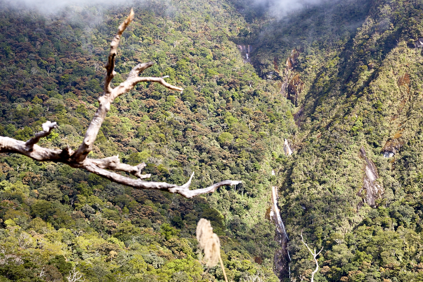
After about 1.5 kilometres we reach the crest of the ridge at somewhere around 2,285 metres. There are stunning views across the lush forest to the mountain where waterfalls tumble down its sides and clouds swirl around wrapping it in an ever-shifting misty veil.
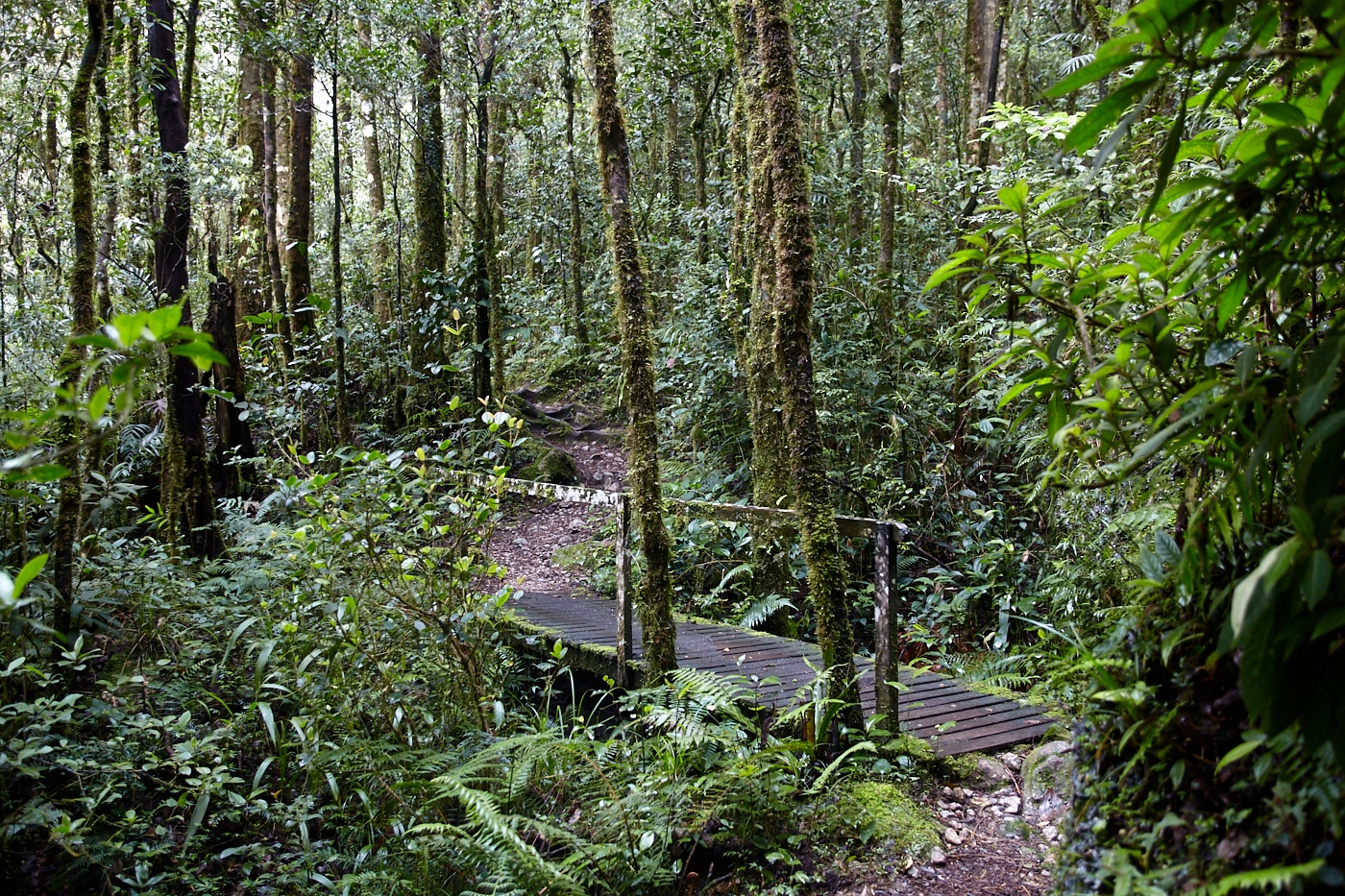
After following the ridge a little way the trail descends steeply back into the forest. Around huge boulders, past pretty waterfalls, over a couple of small streams and across the Kipuyut suspension bridge which spans the West Mesilau River at the bottom of the Mesilau Valley.
Climbing up the other side of the valley is just as steep though it does start to ease off as I move into the upper montane or cloud forest region at around what I guess to be about 2,300 metres. Here mosses and liverworts blanket the trees and the ground is thick with ferns. Rhododendrons are also common though I don’t see anything in bloom. It’s a mysterious environment with the light constantly changing and trees fading into and out of view with the ghostly shifting of the mists.
I hadn’t expected to see any wildlife though I could hear plenty of bird calls. But I was surprised by the lack of bugs. I saw numerous spider webs but never any spiders and the giant red leeches, my guide had assured me, are usually hidden in the leaf litter and really only come out during heavy rains. One animal that did welcome our arrival however were the little mountain ground squirrels which would dart across the path in front of me.


There are several shelters where you can stop for a few minutes rest, replenish your water supplies and have a little snack. For the latter, the squirrels will eagerly join you. Indeed the slightest rustle of an energy bar wrapper or a packet of nuts will embolden half a dozen or more to come and grab pieces from your hand.
At about 4.5 kilometres the trail turns northwest and crosses into a band of orange coloured ultramafic soils. These soils are low in phosphates and high in metals that are toxic to many plants so the species that do grow here look stunted and deformed. This is where you’ll find the famous pitcher plants nephentes villosa and nephentes rajah. The trail levels out a bit as it follows the contours of the mountain for a little more than half a kilometre until it meets up with the Timpohon Trail just above the Layang Layang shelter at 2,700 metres.
Until this point, I’ve had the mountain largely to myself but now I have to share. Not only with other climbers but with porters ferrying supplies and laundry between Timpohon and the rest house at Laban Rata. Whilst I miss the solitude the other climbers do provide moral support which is helpful as the last two kilometres up to Laban Rata are a much tougher climb.

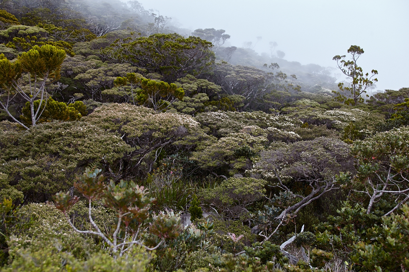
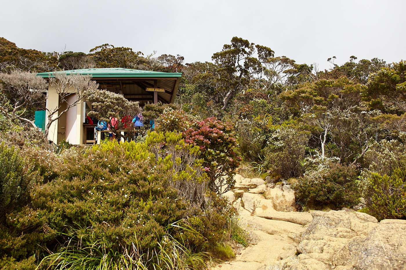
Still on the distinctive ultramafic soil, the path is steep with a combination of uneven steps formed by large boulders and wooden stairs. At about 3,000 metres the soils change quite suddenly and the forest returns to normal. But while the boulders change colour they don’t get any easier and the last stretch of the day’s climb is aggravated by the thinning air. It is a relief to finally arrive at Laban Rata.
There are people who can jog up and down this mountain in about 3-4 hours but for most of us it’s a challenging hike. The shortage of oxygen affects people differently. I’d already met people who were feeling nauseous and others who were starting to get headaches. I was feeling quite shaky about the knees while checking in but after a rest and an early dinner, I felt considerably restored. The clouds are swirling below and the sun is shining above so I go out to the helipad to watch the mountain guides play a game of high altitude volleyball and to gaze upwards at the dark, forbidding summit. Lights out is at 8.30 pm but few people are ready to sleep.
On to the summit
Breakfast is served at 1.30 am. There’s still a long way to the summit and the idea is to get there by sunrise. Sleep has been patchy and I doubt whether I have accumulated more than an hour’s worth. Nevertheless I feel wide awake and tuck into French toast and coffee enthusiastically.

By two o’clock I’m one of the first climbers on the trail. The day is going to be a long one. After reaching the summit we have to return to Laban Rata and check out then get all the way back down to Timpohon. But I’m not thinking of that at the time. Despite the cold and the dark, I feel the excitement of reaching a long-cherished goal.
If you are in Sabah you Might also like a ride on the North Borneo Railway
The trail starts with more stairs and rocks to clamber over. The combination of these and the altitude force me to slow my pace but they can’t dent enthusiasm. There’s not much to see in the small circle of light provided by my headlamp but I do notice sedimentary rocks rapidly giving way to granodiorite.
From about 6.5 kilometres onwards there is a white rope fixed to the rock to guide you along and also to haul yourself up the difficult bits. One such difficult bit occurs almost immediately. The rope disappears into the night along the side of a rock wall that slopes steeply backwards with a ledge that is just wide enough for one boot. Clinging to the rope and leaning as close to the wall as possible you shuffle your way up not being able to see, fortunately, just how far the drop is below.
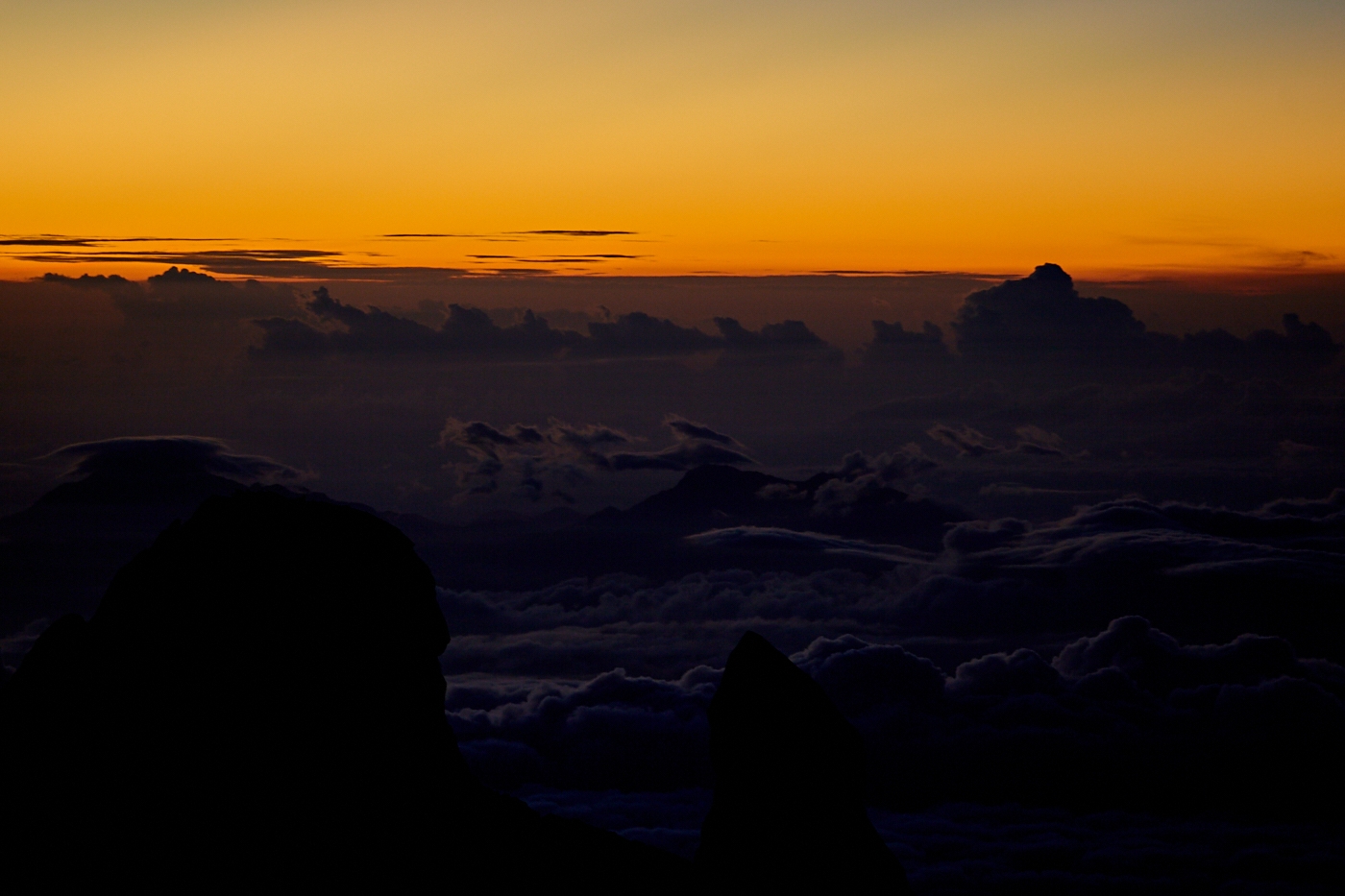
There is a final checkpoint at Sayat Sayat before you make your way onto the vast plateau (main picture). The incline is not as steep here but the surface isn’t completely smooth either and I need to keep my eyes open for occasional steps and fissures. There had been a full moon a few days previously and the sky was clear. So with most of the moon providing adequate illumination I turned off my head lamp and waited for my eyes to adjust. The rope is clearly visible for a good distance ahead, I can also see the dark shapes of the various peaks lurking in the gloom while minerals, presumably the feldspar, in the rock reflect a surprising amount of the moonlight giving the impression of snowdrifts.
There is very little vegetation up here. The ferocious winds and rain ensure that the only soil collects in small crevices where hardy grasses and twisted shrubs fight to survive.
This is probably the least taxing stretch of the entire climb but the thin air makes my limbs feel heavy and I plod along quite slowly. I’m not sure where my guide has got to, I suspect he stayed behind with one of his colleagues to help a larger group negotiate one of the trickier sections. I’m not worried. I enjoy the feeling of being alone on the mountain though I only have to look back to see a line of headlamps not far behind me.
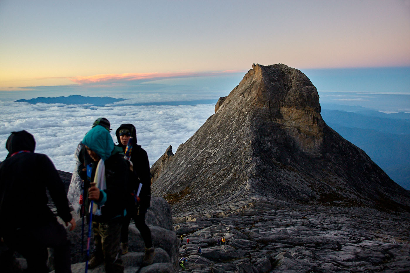
The last stretch to the summit of Low’s Peak is an exhausting scramble over huge boulders. I calculate every move carefully with the words; “slow but sure, slow but sure,” rattling through my head as if on a loop. My guide, as well as quite a few other climbers, have caught up with me now. The guide keeps a watchful eye but he lets me negotiate the rocks on my own for which I’m grateful. Slow but sure I get there.

I’m still one of the early arrivals at the summit but there is not a lot of space and by now it is crowded with climbers jostling to have their photos taken with the summit marker. Selfies have never been my thing but I have my moment on the very top rock. I’m happier to rest a while a couple of boulders down trying to peer into the mysterious Low’s Gully 1,800 metres below. I rest for about fifteen minutes then shoulder my pack again to start the downward journey just as the first streaks of orange leak across the landscape revealing just one distant summit breaking the horizon.
Despite the crowds, it is an awe-inspiring moment and most people stop climbing to watch. But the sun rises pretty fast and by the time I get to the bottom of Lowe’s Peak the entire mountain top is bathed in a gorgeous morning light revealing, in all its glory, the bizarre landscape. This was what I came to see, St. John’s Peak, South Peak, The Ugly Sisters and Donkey Ears Peak among others. I’ve always thought, from the photos I’d seen, that this place looked rather surreal. But actually being here, trudging across this barren expanse of rock with altitude sickness making your arms and legs feel like lead weights and a keen wind biting one side of your face while the sun toasts the other, you really do begin to feel like you could stumble into a Salvador Dali painting at any moment.
This is such an engaging and interesting article Dave. I’m looking forward to seeing more of your website and posts in general.
Thanks Russ, I’m planning to have a new story up in the next couple of days. I should get you out to Bangkok when all this Covid business is over, it will fire up your imagination for more cool stories.
Hi Dave. Just found your article re climbing Mt Kinabalu from the Mesilau side. I enjoyed the read even though I have no desire to climb to the summit (no orchids that high!). I have been travelling to Sabah regularly for some 15 years now and the Mesilau track is one of my favourite places to explore. I specialise in finding and photographing orchids in situ and was looking for info regarding the reopening of the Mesilau track since the earthquake in 2015. I was there last year (July 2019) and the track was still closed. I am unclear as to when you made the climb from that side. Is this recent?
The Mesilau track was cut by Sheila Collenette back in the late 1950’s/early 1960s. She was the first person to climb the mountain from that side. I had the great fortune to meet her in the UK a few years ago and spent a wonderful day with her and her husband Peter discussing their adventures in Sabah (and later in Saudi Arabia where she documented the flora of the country and wrote the definitive book). Peter was a geologist with BP and had access to aerial maps which made identifying the ridges on the mountain much easier. Sheila could plan the routes using these maps – not that it always turned out the way she had hoped though. The stuff great stories are made of. Unfortunately, she died in 2017. She was an amazing trail blazer.
I always find something new whilst climbing this track and can’t wait to explore it again once we learn to live with COVID.
You mentioned that you didn’t see any orchids on the Mesilau track. Here is the link to my photos of the orchids we found when when we last climbed the Mesilau track in 2011.
https://www.flickr.com/photos/jvinoz/albums/72157635308456671
Hi John, Thanks for the info on Sheila Collenette, I didn’t know of her.
As far as I know the Mesilau Trail is still closed and I am not aware of any plans to re-open it. Which is a shame, it is by far the nicer and more interesting of the two trails.
I was there about two weeks before the earthquake that closed them, in 2015. I believe the Timpohon was rerouted to go around the parts that were too badly damaged to repair. I’m not sure why they can’t do the same for Mesilau, maybe demand is just not strong enough. On the day I went I only saw one other group of two Malaysians and their guide.
Thanks for sharing your flickr, there are some lovely images there. I’m sure there were orchids to be seen on my climb, I have to confess I’m just not very good at looking for them. I would probably have missed the pitcher plants too if the guide had not pointed them out.
I hope they will reopen Mesilau Trail in future. Or at least make it a descent only trail, so as to reduce congestion along the Timpohon Trail. Go straight down to Mesilau Nature Resort and other tourist spots in that area.
I believe somewhere near the Nepenthes shelter along Mesilau Trail is a wooden bridge across a river. Has that bridge been destroyed by the earthquake?
Thanks for the comment,
There were about three bridges as I recall. Two of them were quite small but it shouldn’t have been a problem repairing or rebuilding any of them so I can only guess there is damage elsewhere as well.
Mesilau was by far the prettier of the two trails. My suggestion would be to use that for the climb up and Timpohon for coming down when peoples legs are weary and they feel less inclined to stop and enjoy their surroundings.
I think they should also promote the Mesilau Nature Resort a bit more. Had I realised before I went I could have happily spend a day or two just exploring the surroundings there.