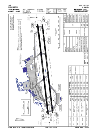


UTTT - Tashkent Islam Karimov International Airport
Located in Tashkent, Uzbekistan
ICAO - UTTT, IATA - TAS
Data provided by AirmateGeneral information
Coordinates: N41°15'24" E69°16'54"
Elevation is 1417 feet MSL.
View others Airports in Toshkent
Operational data
Special qualification required
Current time UTC:
Current local time:
Weather
METAR: UTTT 052230Z 07004KT CAVOK 16/13 Q1015 R08R/CLRD70 NOSIG
TAF: TAF UTTT 051700Z 0518/0618 32010KT 7000 FEW060CB BKN100 PROB40 TEMPO 0518/0524 VRB15KT -TSRA SCT050CB
Communications frequencies: [VIEW]
Runways:
| RWY identifier | QFU | Length (ft) | Width (ft) | Surface | LDA (ft) |
| 08L | 82° | 13123 | 197 | CON | |
| 26R | 262° | 13123 | 197 | CON | |
| 08R | 82° | 12812 | 148 | ASP | |
| 26L | 262° | 12812 | 148 | ASP |
Airport contact information
Address: Tashkent Uzbekistan