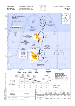
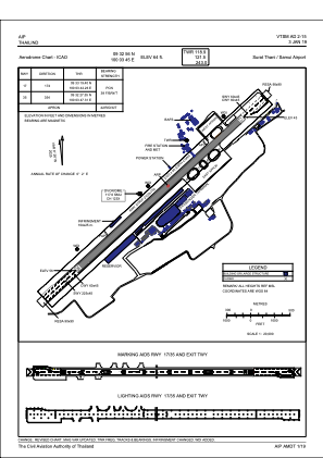


VTSM - Surat Thani / Samui Airport
Located in Samui, Thailand
ICAO - VTSM, IATA - USM
Data provided by AirmateGeneral information
Coordinates: N9°32'56" E100°3'45"
Elevation is 64 feet MSL.
View others Airports in Nakhon Si Thammarat Province
Operational data
Special qualification required
Current time UTC:
Current local time:
Weather
METAR: VTSM 071400Z VRB02KT 9999 FEW020 31/26 Q1011 NOSIG
TAF: TAF VTSM 071100Z 0712/0812 14005KT 9999 FEW020 SCT100
Communications frequencies: [VIEW]
Runways:
| RWY identifier | QFU | Length (ft) | Width (ft) | Surface | LDA (ft) |
| 17 | 174° | 6890 | 148 | ASP | |
| 35 | 354° | 6890 | 148 | ASP |
Airport contact information
Address: Samui Thailand