Going up and down some of the world’s most thrilling bus routes can sometimes feel like riding a roller coaster. Busbud – a worldwide bus and travel company that allows travelers to search, compare, and book bus tickets for anywhere their heart desires – offers plenty of routes that will make even thrill seekers hold onto their seat belts.
What do these routes look like? They’re a real-life cruise through the clouds. We chose a few routes offered by Busbud with pretty significant elevation changes to show you. Keep reading to get that rush.
One Bus Ticket to Elevation, Please
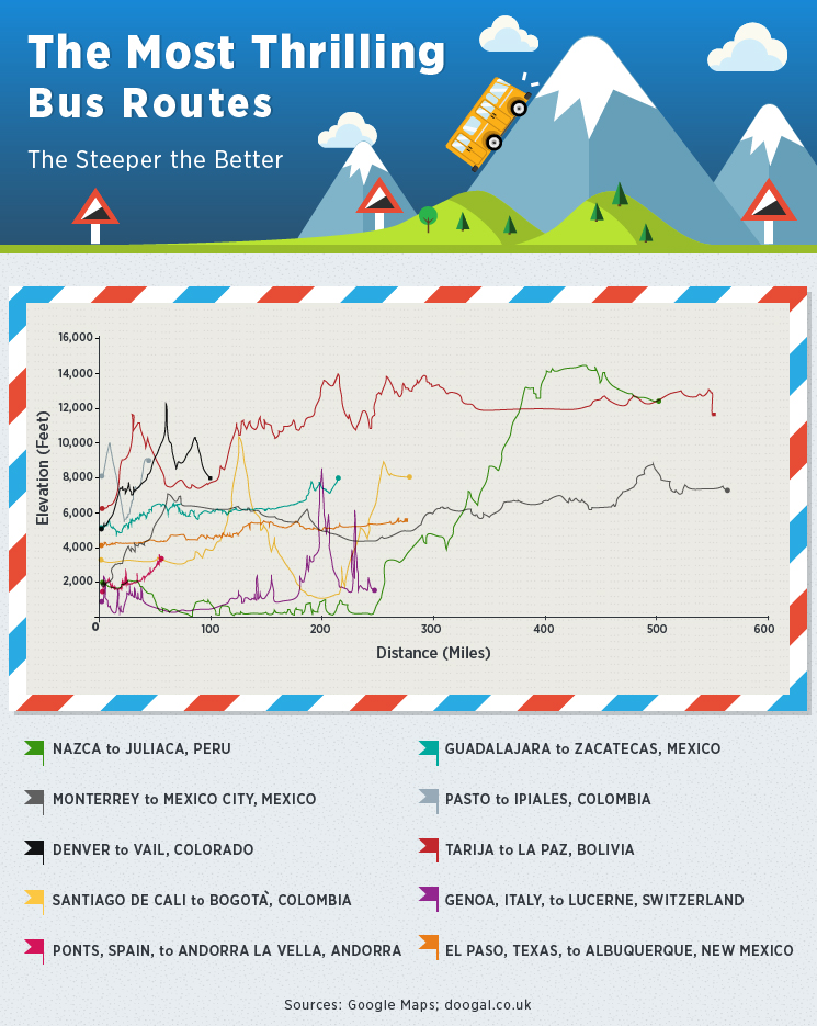
Check out the top 10 most thrilling bus routes offered by Busbud. The biggest elevation change occurs along the route from Nazca to Juliaca, Peru. While these two cities may seem fairly close in distance (they’re 548 miles apart), the path to the mountainous Juliaca gains an impressive 10,623 feet.
While other routes outlined have smaller elevation changes, all routes exceed 1,000 feet from point A to point B. Let’s take a closer look at the top three routes to see what makes them so electrifying.
Nazca to Juliaca a Steep Seaside Climb
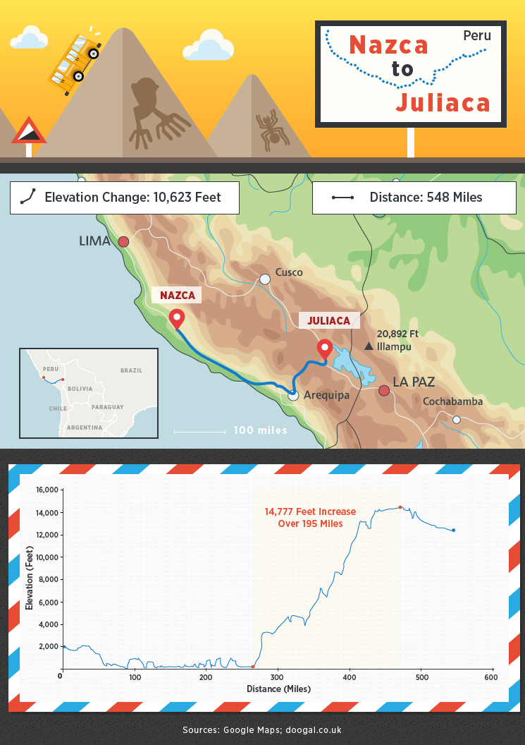
From Nazca to Juliaca, travelers are in for a real treat when it comes to steep climbs and a wild elevation gain. One of the first points of interest is the small fishing village of Chala, where a fascinating archaeological site sits nearby. The coastal highway continues south before heading east – and up. Before starting the climb, you’ll pass the town of Camaná; it’s an urban coastal center in Peru known for its beaches.
Once you skirt past La Punta, it’s an uphill climb from there. The mountainous region gains elevation at a rapid clip and the highway eventually gives way to magnificent vistas. You’ll travel near Peru’s second largest city, Arequipa, which is surrounded by three volcanoes, and then voyage along a winding highway through the protected area of the Reserva Nacional Salinas y Aguada Blanca. Incidentally, this checks in at over 16,000 feet above sea level. Prepare to deal with possible altitude sickness. The good news is that the area is known for its nice population of vicuñas – doe-eyed members of the camel family.
The town of Juliaca is your endpoint (and around 3,500 feet lower than the highest point along your journey), which you will arrive at after nearly 13 hours of bus travel.
Monterrey to Mexico City Has Never Looked so Pretty
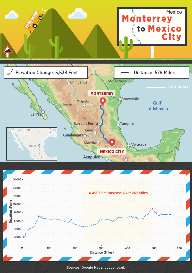
The approximate 10-hour trip from Monterrey to Mexico City is next on our list of Busbud’s most thrilling routes. The journey is around 579 miles from start to finish, and you gain significant elevation along the way – to the tune of 5,500 feet (keep in mind that Denver, Colorado, sits at an elevation of around 5,100 feet above sea level). Monterrey clocks in a few hundred feet below 2,000, and Federal Highway 57 heads in a southerly direction to your destination, which sits at 7,315 feet.
Along the way, your bus will skirt a Mexican national park, while the highway winds south toward Matehuala, a relatively remote town. Soon, you’ll find yourself near the city of San Luis Potosí, which is a throwback gem, resplendent with buildings from Mexico’s colonial times. Of particular note, the highway shoots through a mountain pass near Calpulalpan. Near Querétaro (another gorgeous colonial town), you’ll exit onto 57D, jogging a little east as you continue your journey.
The next significant city is San Juan del Río, which is known for its thermal waters and spas. From there, the highway snakes southeast into the northern suburbs of Mexico City.
While the route from Monterrey to Mexico City is not known as a highly dangerous road due to twists and turns, it still has a ton of elevation gain as you traverse the countryside from point A to point B.
Denver to Vail Is No-Fail Fun
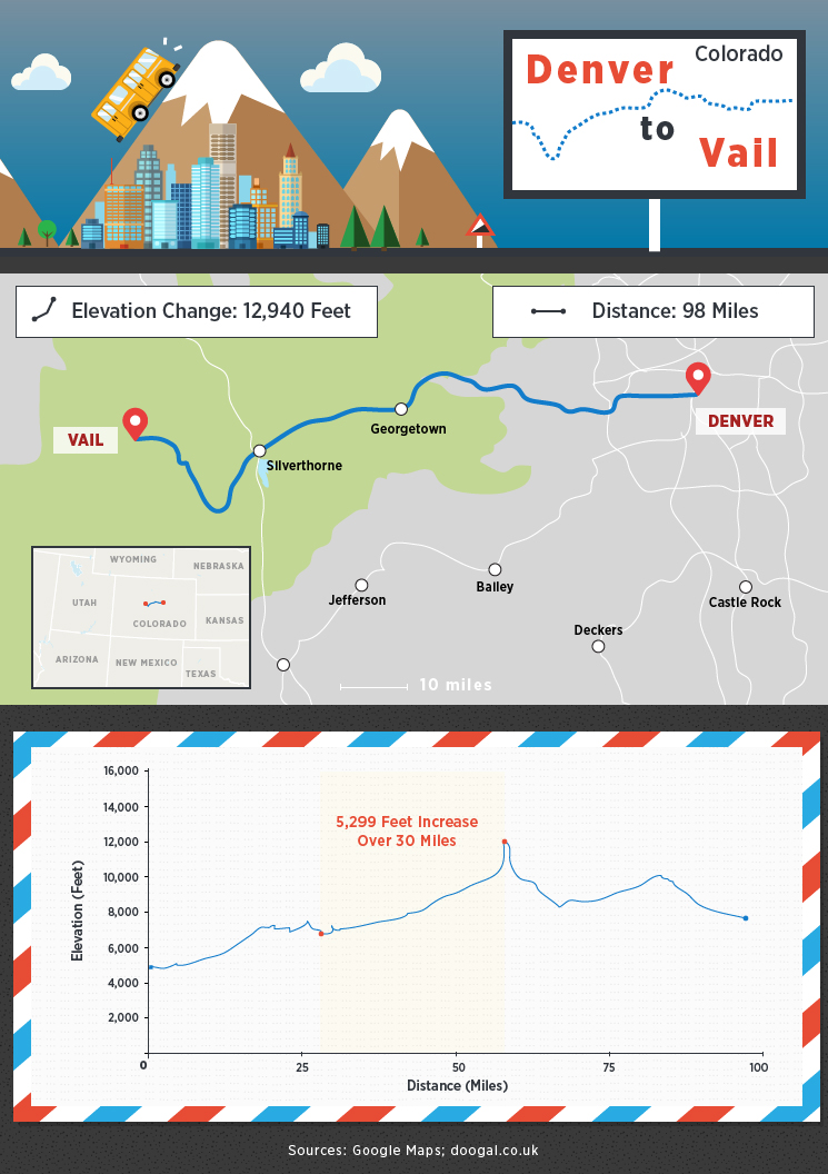
A two-hour bus ride west from Denver, Colorado, may not sound like a thriller of a trip. However, when you’re squirrelling your way through the Rocky Mountains and gaining nearly 3,000 feet of elevation, it’s an entirely different story.
Denver checks in at nearly a mile above sea level, and Vail sits at over 8,100 feet. While the route seems to be a simple one (hit Interstate 70 and head west), it’s anything but. As you leave the Denver metro area and approach the front range of the Rocky Mountains, you will see the bold line of the Rockies stretching out before you, giving you a hint of what’s to come.
Traversing further westward, you’ll hit Idaho Springs and Lawson before your bus starts trending southward. I-70, in fact, passes near many small Colorado towns for around 60 miles before it hits the Eisenhower Tunnel, which is a marvel of modern engineering – and also, incidentally, tunnels directly through the Continental Divide.
You’ll pass Dillon Reservoir on your left before turning northward through a thrilling section of the interstate called the Vail Pass. This part of the highway features a steep grade (around 7 or 8 percent) and a few white-knuckle hairpin turns. You will eventually disembark in Vail, Colorado.
Thrills Throughout the Western Hemisphere
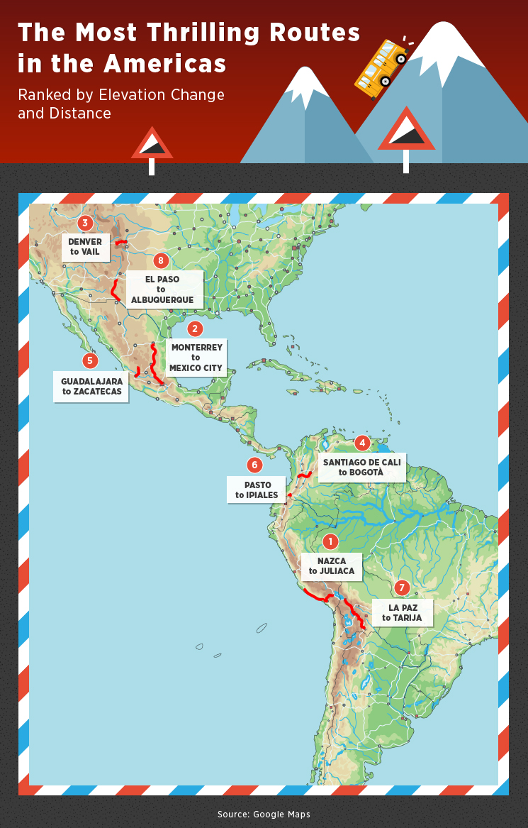
While the three routes we’ve examined hold some big thrills, there are quite a few more in the Western Hemisphere that will make you grip your seat tighter. In the U.S., travelers are in for a scare or two from El Paso, Texas, to Albuquerque, New Mexico. A voyage from Guadalajara to Zacatecas, Mexico, may be more exciting than bargained for. Even in Colombia, a steep ride can be found from Santiago de Cali to Bogotá. The country also has another notable track for thrill seekers – Pasto to Ipiales. A little further south, one can experience a fun trip from La Paz to Tarija, Bolivia.
Ponts to Andorra la Vella a High Altitude Adventure
For a scenic and thrilling jaunt through Europe, check out the trail from Ponts, Spain, to the small country of Andorra. The relatively short route (around 54 miles) between the two areas may not sound extreme, but traveling through this part of the world opens up dizzying panoramas of the Pyrenees Mountains that give voyagers serious elevation gains (over 2,000 feet) as well as gorgeous views.
Travelers will journey northbound on Spanish highway C-14, which skirts Sierra de Aubenç y Roc de Cogul, a place of natural interest in Spain. Locales along the way include Seu d’Urgell and La Farga de Moles before crossing the border into Andorra.
The destination point of Andorra la Vella is the capital city of Andorra and is steeped with tradition. Evidence of its long history can be spotted around town and opportunities for outdoor excursions are plentiful. Situated at 3,261 feet above sea level, the journey to arrive at this mountainous locale is no small feat, and will give thrill seekers a ride to remember.
Genoa to Lucerne a Trip into the Alps
Another European thrill-seeker route of note will take travelers from the northern Italian city of Genoa through a large plain and eventually through the Alps, arriving at the town of Lucerne, Switzerland.
The 246-mile trek begins on Italian highway A7, which is the main route between Genoa and Milan. As you near the one-time Imperial Roman capital of Milan, you’ll travel through the Parco Agricolo Sud Milan, an expansive natural protected area. As you near the border of Switzerland, the road becomes more interesting and mountainous.
Once you really get into the Alps, though, you’re not only gaining elevation, but you’re treated to some of the most breathtaking views in Switzerland. You’ll pass near the village of Göschenen, and although you’ll spend a lot of time out in the open, the route will take you through mountain tunnels, including the Kirchenwald Tunnel outside of Lucerne. Once you’ve traveled to your destination, you’ll have gained an impressive 1,400 feet in elevation.
Coming ’Round the Mountain
If you’re looking to book a bus trip, be sure to check out our website first. No matter where in the world you’re setting out for, you’ll find everything you need. From general information to schedules and, of course, tickets – we have access to the wheels that take your higher.
Methodology
The most thrilling routes were determined by pulling Busbud data involving some of the highest cities in the world by altitude. After determining the routes and relative altitudes we created ranking measurements for these respective factors. By combining these metrics to determine maximum altitude change over the shortest distance we were able to form a “thrilling” ranking.
Sources
http://www.lonelyplanet.com/peru/chala/introduction
http://elevation.maplogs.com/poi/carr_panamericana_sur_peru.72411.html
http://www.lonelyplanet.com/peru/arequipa-and-canyon-country/arequipa/introduction
http://www.lonelyplanet.com/peru/camana/introduction
http://www.lonelyplanet.com/peru/reserva-nacional-salinas-y-aguada-blanca/introduction
https://www.tripadvisor.com/LocationPhotoDirectLink-g294313-d2312272-i87681660-Salinas_y_Aguada_Blanca_National_Reserve-Arequipa_Arequipa_Region.html
http://traveltips.usatoday.com/historic-sites-matehuala-mexico-35652.html
http://www.visitmexico.com/en/san-luis-potosi
http://www.visitmexico.com/en/queretaro
http://www.tourbymexico.com/quere/sanjuan/sanjuan.htm
http://egsc.usgs.gov/isb//pubs/booklets/elvadist/elvadist.html
http://www.dangerousroads.org/north-america/mexico.html
http://www.dangerousroads.org/north-america/mexico/6075-mexico-57d.html
https://www.codot.gov/travel/eisenhower-tunnel/description.html
http://www.dangerousroads.org/south-america/colombia/5767-alto-de-la-l%C3%ADnea.html