NOTICE: Information listed below may not be current.Airport Ident: MMCL
| Airport Name: CULIACAN INTL, Mexico
Latitude: N2445.9 Longitude: W10728.5
Field Elevation: 108' Variation: E9° as of 01/06
Time Zone: UTC-7(-6DT)
Daylight Savings: First Sunday in April to the last Saturday in October
Customs: N/A
|
|
| DISTANCE from: | KTEB to MMCL = 1925 nm
| KMIA to MMCL = 1473 nm
| KORD to MMCL = 1418 nm
| KDAL to MMCL = 739 nm
| KSEA to MMCL = 1534 nm
| KLAX to MMCL = 794 nm
|
|
| AIRPORT TYPE: | | Active, joint (civil and military) use. Airports jointly controlled, used and/or operated by both civil and military agencies. The military agencies must be permanent operational flight line type tenants, with or without aircraft stationed on the airport. Minimum facilities are available which include: control tower (or some similar control system, such as a Flight Service Station which issues clearances and advisories when there is no tower or the tower is not in operation), lighting (may be flare pots, etc.), petrol, oils and lubricants (POL), and facilities for organizational maintenance or better. |
|
Rotating Beacon: YES
|
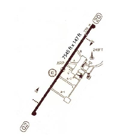
| RUNWAY INFORMATION: | Runway Ident: 20 /02
Runway Length: 7546
Runway Width: 148
Runway Surface: ASPHALT, ASPHALTIC CONCRETE, TAR MACADAM, OR BITUMEN BOUND MACADAM (INCLUDING ANY OF THESE SURFACE TYPES WITH CONCRETE ENDS).
Runway PCN Rating: 100FAXT - Flexible, Subgrade-HIGH, Tire Pressure-MEDIUM LIMITED TO 217 PSI
Runway PCN Evaluation Method: Technical Evaluation.
Runway Open: YES
| Runway 20 Information
Runway True Heading: 213°
Runway Displaced Threshold: 88.6'
Takeoff Distance Available: 7546
Landing Distance Available: 6660
Runway Latitude: N2446.4
Runway Longitude: W10728.2
Runway Elevation:
Runway Slope: N/A
Runway TDZE:
Runway Lighting: HIRL, REIL, PAPI
| Runway 02 Information
Runway True Heading: 33°
Takeoff Distance Available: 7546
Landing Distance Available: 7546
Runway Latitude: N2445.4
Runway Longitude: W10728.9
Runway Elevation:
Runway Slope: N/A
Runway TDZE: N/A
Runway Lighting: HIRL, REIL, PAPI
|
|
|
COMMUNICATION INFORMATION
APPROACH CONTROL - APP
119.75
AUTOMATIC TERMINAL INFORMATION SERVICE - ATIS
127.8
TOWER - TWR
118.5
|
AIRPORT NAVAIDS
CUL - CULIACAN (VOR-DME) - ON FIELD
|