How To Fly To Svolvaer
Flights to Svolvaer can be conducted using any X-Plane or FSX aircraft that is suitably equipped to fly a localizer approach (with NDB) to a roughly 2,600ft runway length. The stock Cessna Caravan, Cessna 172, Maule and Baron are good choices if using FSX, while the Cessna 172 and King Air C-90 are good default aircraft choices for X-Plane. Those seeking more realism could go with the mid-level Virtualcol Dash 8 Series for FSX/P3D (s) or the DHC-6 Twin Otter for X-Plane (s) both of which have Wideroe liveries either included or available for them. While stock X-Plane and FSX/P3D airports can be used, I‘d recommend enhancing the experience with custom scenery packages. Aerosoft has a beautiful Svolvaer X scenery available (s) while Trevor ‘tdg’ Guest has created a nice donationware approximation of the airfield for X-Plane: s instrument approach plates to Svolvaer (and all of Norway) are available at the Avinor website.
In this issue of Challenging Airports, we return to the frozen fjords of Norway. We’ve wandered the globe in our search for challenging and difficult airports but we could write an entire book about the plethora of quirky airports that dot the Norwegian landscape. Owing to the widely spread population centres, harsh geography and temperamental weather, Norway is an adventurous pilot’s dream location, or nightmare, depending on your level of confidence! So, strap in for the scenic flight into the coastal destination of Svolvaer.

Getting there
Visitors and residents to Svolvaer have a variety of transportation options to reach the area that include a relatively new (2007) road to the mainland (E10) as well as ferry services. The small regional airport is serviced by Wideroe with the venerable Dash 8-100/200, an aircraft particularly well suited to the short runways that characterise many of Norway’s secondary airports. Typical destinations include Bodo, Leknes, Oslo, Stokmarknes and Tromso. Civil aviation aircraft are also regularly seen at Svolvaer, as well as medical evacuation flights.

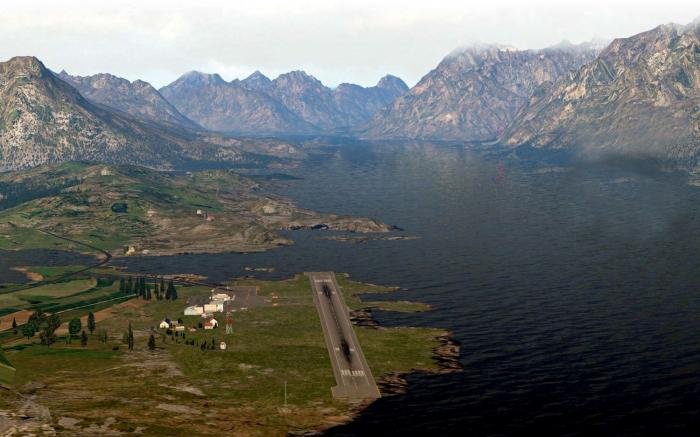
The airport
The single runway airstrip lies about two and a half miles east of the town of Svolvaer on one of the few relatively flat locations in the area. The 3,104ft asphalt Runway 01/19 parallels the Austnesfjorden waterway which extends northward into a rugged mountain range that soars quickly into the typically low hanging clouds. Though the runway length is listed as 946 metres (3,104ft), a close look at the aerodrome chart indicates that the actual landing distance available (LDA) is a mere 806 and 776 metres (2,644ft and 2,546ft) for Runways 01/19 respectively, so consider that in your performance planning. High terrain exists in all quadrants, with the safest escape route being towards the open water southwest of the airfield. VFR departures and arrivals need to be mindful of the local area geography and care needs to be taken to avoid flying into closedoff valleys or narrow passages that would prevent aircraft from executing a 180° turn.

Svolvaer is positioned at just over 68° North latitude, putting it within the Arctic Circle, meaning that there are periods in the summer when the sun is above the horizon for 24 hours. Of course, that also means that in the winter, there are periods of extended darkness where the sun never peeks over the horizon. The region features an ‘Oceanic climate’ that tends to moderate temperatures despite the high northern latitude, although that comes at the cost of uplifting clouds that have their moisture squeezed from them, resulting in heavier and more frequent precipitation than areas further inland. As weather is a primary consideration when operating to Svolvaer, alternates such as Bodo (57nm) or Tromso (127nm) should be kept in your back pocket if weather conditions at Svolvaer start to deteriorate. Keep in mind also the warning that windshear and/or turbulence eddies may occur on short final to Runway 19 when winds are blowing from the southwest to northwest above 25 knots. The airport is uncontrolled but weather and traffic information are available on the AFIS frequency.
The field is lit with adjustable intensity runway lights and both ends of the runway are served by a 4.5° PLASI (Pulse Approach Light Approach Slope Indicator). For those unfamiliar with the PLASI indications: above glidepath = pulsing white, on glidepath = steady white, slightly below glidepath = steady red, below glidepath = flashing red. Due to the short runway, there is also a balked landing guidance light 290m (about 950ft) from the landing threshold. It is worth noting that some default scenery in our simulators only feature VASI lighting while some add-on scenery such as Aerosoft’s Svolvaer X will give you more accurate runway markings and lighting.

Approaches
Approach aids include a localizer approach, RNAV/GPS approach and a ground-based differential GPS corrected signal offering a GLS approach. The LOC approach has the lowest straight-in landing minimums for category A aircraft (<91 knots) of a 361ft ceiling and a missed approach point 2nm from the threshold. Category B aircraft have significantly higher minimums due to their higher manoeuvring speed during the missed approach turns, while Category C and D aircraft are not even authorised. As with many airports that have terrain nearby, minimums have less to do with what your aircraft is capable of doing during the approach segment and more to do with what it is capable of achieving during the missed approach climb. Thus, aircraft capable of meeting 5% climb gradients will have lower minimums than those only able to achieve 2.5% gradients. The thought process is that you have to have enough power and performance to dig yourself out of a deeper hole.
The most critical missed approach note among the various approach plates is attached to the special authorisation GLS RWY 01 missed approach that requires the missed approach to be manually flown with a maximum indicated airspeed of 104 knots and a minimum 25° bank angle during the missed approach turn. This kind of manoeuvre, if not practised, is a prime recipe for spatial disorientation as the aircraft pitches, rolls and accelerates away from the missed approach point.
All of the published approaches have Category A and B circling minimums published, with the lowest being the special authorisation GLS RWY 01 Category A with a mere 540ft (MSL) altitude. Circling at that altitude, in dim light, just below the weather with mountains lurking nearby, is undoubtedly a heart-pounding affair. The circle to Runway 19 is to be accomplished east of the field, over the water and the southern tip of the peninsula that juts into Austnesfjorden. Manoeuvring at low altitude and low speed, regardless of weather or lighting, is something that should be carefully planned and executed. Even experienced aircrews have got into trouble on circling approaches to the most benign airports.

Aircraft and performance
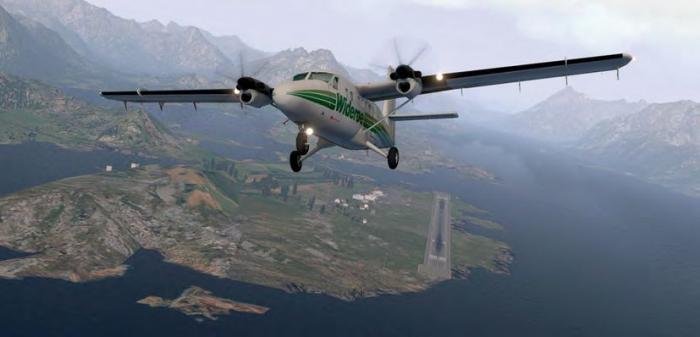
Wideroe, with its highly trained flight crews, regularly operates its Dash 8-100 and 200 aircraft to Svolvaer. At around 2,600ft of runway, Svolvaer isn’t the shortest runway we’ve visited during this series by any means (Saba’s Juancho E Yrausquin Airport is half as long!) but the frequent runway contamination and tight IFR approaches make it worthy of inclusion. Larger aircraft such as the Dash 7 (also operated by Wideroe) have made appearances at Svolvaer, but by and large Twin Otters and Dash 8s are the main migratory species to frequent the area. Air ambulance operators using King Airs, some private Cheyennes and other small turboprops have also flown through Svolvaer in addition to many light general aviation piston singles.

As we are unconstrained in our adherence to regulations in the sims we fly, the runway length at Svolvaer is certainly capable of handling many of the aircraft in our virtual hangars such as certain military turboprops, many civilian turboprops and (incredibly) some business jets. The Falcon 7X, for instance, has a listed landing distance of only 2,070ft. While this doesn’t give us much margin for error and it certainly doesn’t factor in a contaminated runway, the challenge is all too appealing to those of us who wonder what is possible. Keep in mind that whatever aircraft you choose, turning bays exist at both ends of the runway for backtracking on the runway and ramp space is fairly tight.
With regard to approaches, at the minimum you’ll need an aircraft capable of shooting a localizer approach with a transition from an NDB (Skrova), while the GNSS and GLS approaches will require an approach-capable GPS in your aircraft. Missed approach holding fixes include the Skrova NDB and ABTIK GPS waypoint. You can further improve your odds of success in poor weather or darkness by utilising an aircraft with some sort of synthetic vision, HUD or infrared display. All are particularly useful when conducting circling manoeuvres in darkness. Also, a moving map display and/or TAWS (Terrain Awareness and Warning System) is extremely useful for supplementing your situational awareness.

Conclusion
Regardless of the type of aircraft you choose to fly to Svolvaer, you will be either challenged by tough weather and an interesting approach or graced with a stunning panorama whether shooting the straight-in approach to Runway 1 or the dramatic circle to 19. Proficiency in your aircraft of choice, adherence to the charts, respecting the weather, and formulating a Plan B and C prior to departure can go a long way to making your flight a safe one.
Chris Frishmuth