
Risk of Degradation and Coastal Flooding Hazard on Geoheritage in Protected Areas of the Semi-arid Coast of Brazil

 ,
,  and
and 
Abstract
:1. Introduction
2. Materials and Methods
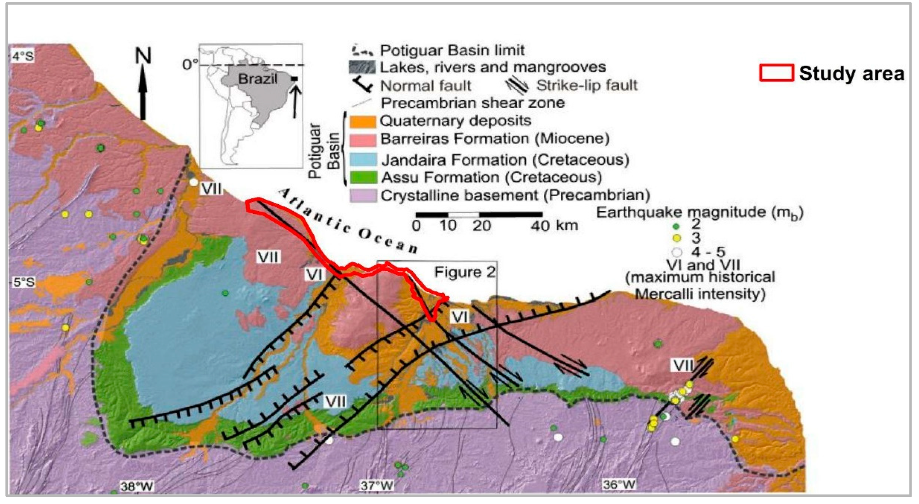
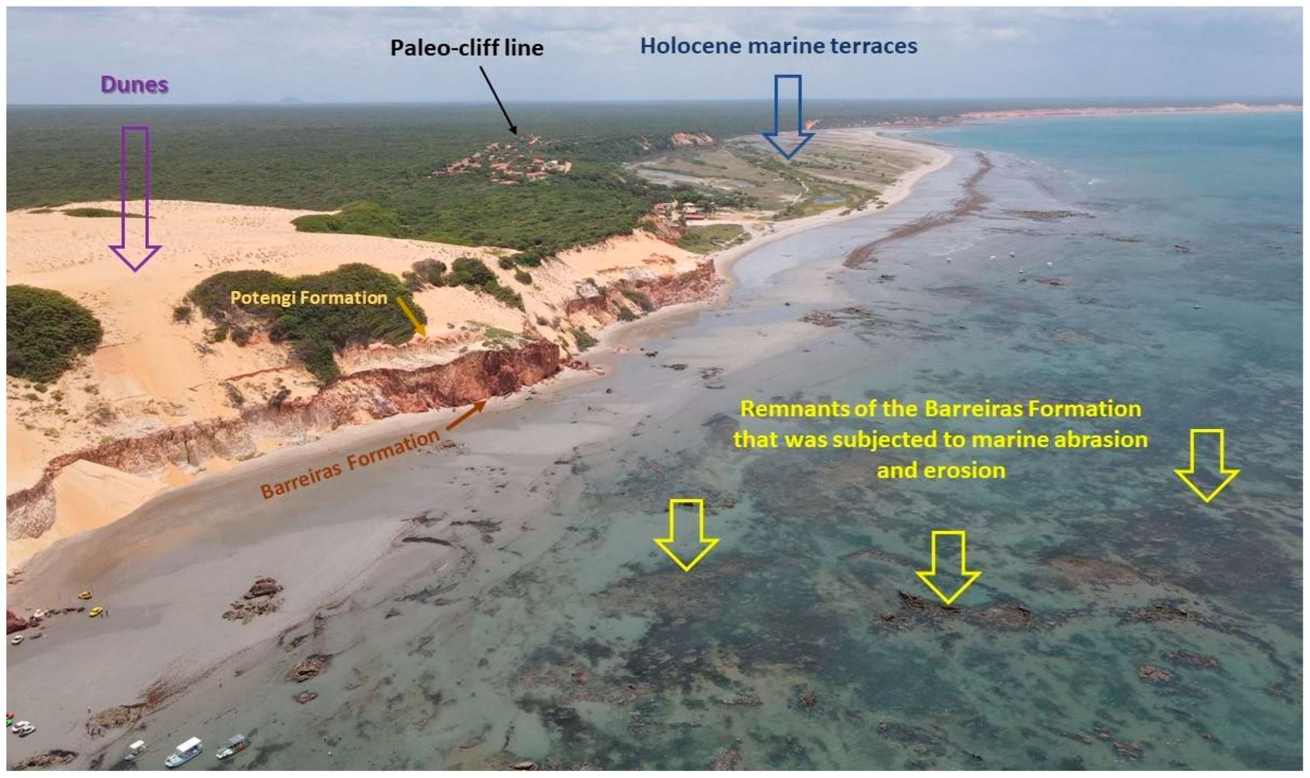
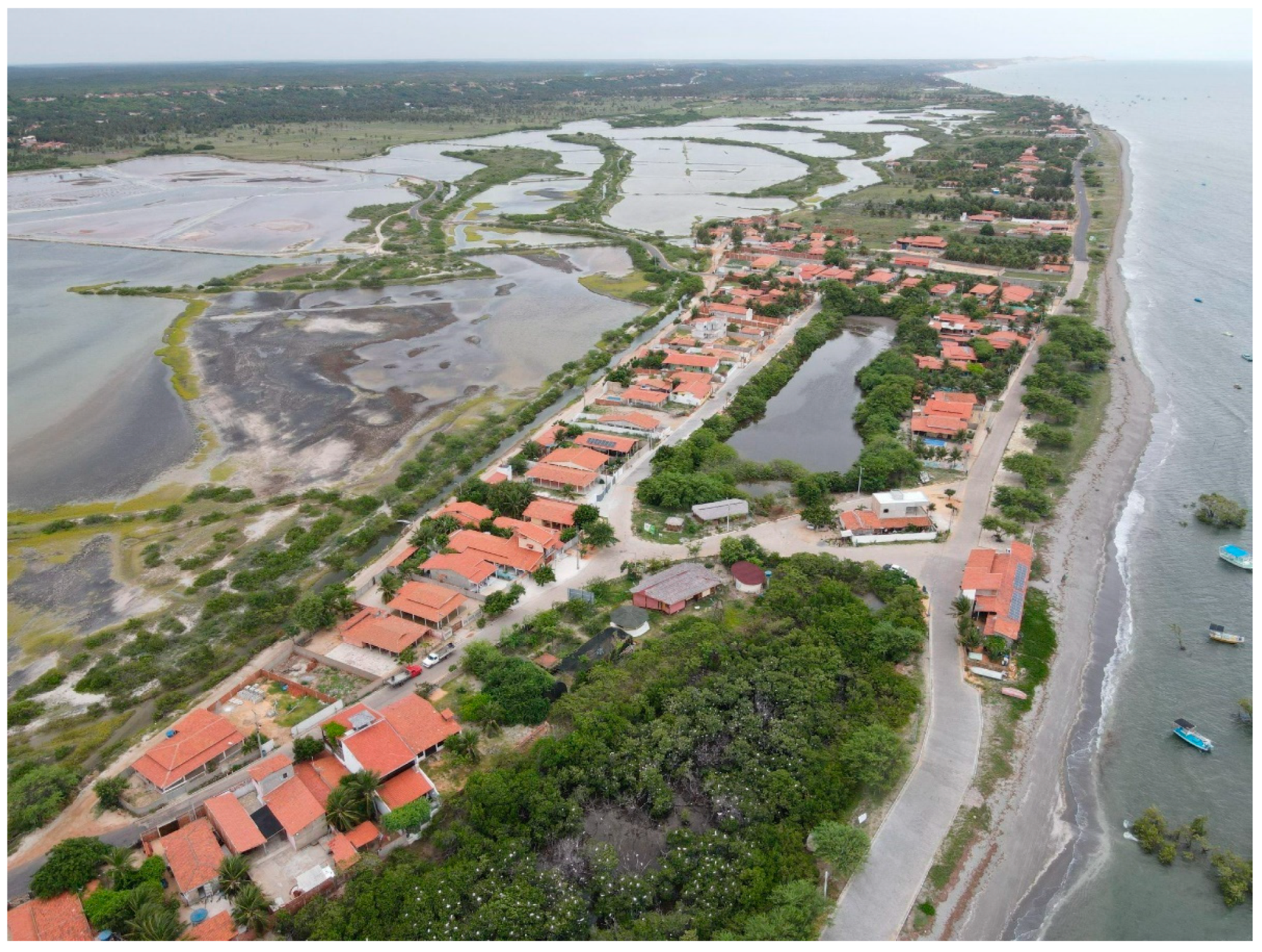
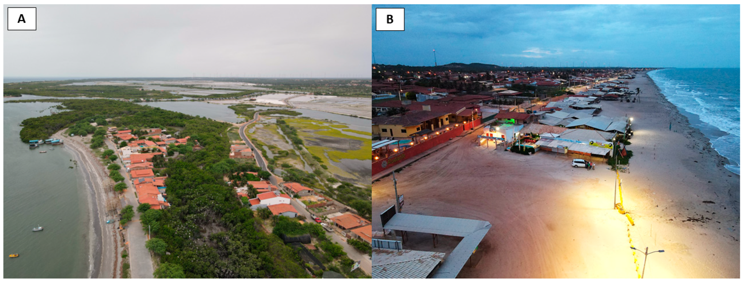
2.1. Study Area
2.2. Procedures for Quantitative Assessment
3. Results and Discussion
4. Conclusions
Author Contributions
Funding
Data Availability Statement
Acknowledgments
Conflicts of Interest
References
- Melillo, J.M.; Lu, X.; Kicklighter, D.W.; Reilly, J.M.; Cai, Y.; Sokolov, A.P.O. papel das áreas protegidas na mitigação das mudanças climáticas. Ambio 2016, 45, 133–145. [Google Scholar] [CrossRef]
- Štrba, L.; Kolačkovská, J.; Kudelas, D.; Kršák, B.; Sidor, C. Geoheritage and Geotourism Contribution to Tourism Development in Protected Areas of Slovakia—Theoretical Considerations. Sustainability 2020, 12, 2979. [Google Scholar] [CrossRef]
- Bruno, J.F.; Bates, A.E.; Cacciapaglia, C.; Pike, E.P.; Amstrup, S.C.; Hooidonk, R.; Henson, S.A.; Aronson, R.B. Climate change threatens the word’s marine protected areas. Nat. Clim. Change 2018, 8, 499–503. [Google Scholar]
- Diário Oficial da União. Lei nº 9.985, de 18 de julho de 2000; Brazilian Federal Government: Brasília, Brazil, 2000.
- Ogawa, F.S. Análise das Projeções de Mudanças Climáticas no Quinto Relatório do IPCC Dentro das Áreas Protegidas Brasileiras [Analysis of Climate Change Projections in the IPCC Fifth Report within Brazilian Protected Areas]. Bachelor’s Thesis, Universidade Estadual Paulista “Júlio de Mesquita”, São Paulo, Brazil, 2015. [Google Scholar]
- Pereira, P.J.S. Patrimônio Geomorfológico: Conceptualização, Avaliação e Divulgação. Aplicação ao Parque Natural de Montesinho [Geomorphological Heritage: Conceptualization, Evaluation and Dissemination. Application to the Natural Park of Montesinho]. Ph.D. Thesis, Universidade do Minho, Braga, Portugal, 2006. [Google Scholar]
- Gray, M. Geodiversity: Valuing and Conserving Abiotic Nature, 2nd ed.; John Wiley & Sons: Chichester, UK, 2013; 495p. [Google Scholar]
- Brilha, J. Inventory and Quantitative assessment of geosites and geodiversity sites: A review. Geoheritage 2016, 8, 119–134. [Google Scholar] [CrossRef]
- Meira, S.A.; Morais, J.O. Os conceitos de geodiversidade, patrimônio geológico e geoconservação: Abordagens sobre o papel da geografia no estudo da temática [The concepts of geodiversity, geological heritage and geoconservation: Approaches on the role of geography in the study of the theme]. Bol. Geogr. 2017, 11, 129–147. [Google Scholar] [CrossRef]
- Brilha, J. Geoheritage: Inventories and evaluation. In Geoheritage; Reynard, E., Brilha, J., Eds.; Elsevier: Chennai, India, 2018; pp. 69–85. ISBN 9780128095317. [Google Scholar]
- Gray, M. Geodiversity: A significant, multi-faceted and evolving, geoscientific paradigm rather than a redundant term. Proceedigns Geol. Assoc. 2021, 132, 605–619. [Google Scholar] [CrossRef]
- Kubalíková, L.; Irapta, P.N.; Pál, M.; Zwoliński, Z.; Coratza, P.; Van Wyk de Vries, B. Visages of Geodiversity and Geoheritage: A Multidisciplinary Approach to Valuing, Conserving and Managing Abiotic Nature; Geological Society, Special Publications: London, UK, 2023. [Google Scholar]
- Prosser, C.D.; Díaz-Martínez, E.; Larwood, J.G.H. Conservação de geossítios: Princípios e prática. In Geoheritage; Reynard, E., Brilha, J., Eds.; Elsevier: Chennai, India, 2018; pp. 193–221. ISBN 9780128095317. [Google Scholar]
- Intergovernmental Panel on Climate Change (IPCC). Climate Change 2022: Impacts, Adaptation and Vulnerability; Contribution of Working Group II to the Sixth Assessement Report of the Intergovernmental Panel on Climate Change; Pörtner, H.-O.O., Roberts, D.C., Tignor, M., Poloczanska, E.S., Mintenbeck, K., Alegría, A., Craig, M., Langsdorf, S., Löschke, S., Möller, V., et al., Eds.; Cambridge University Press: Cambridge, UK, 2023; 3056p. [Google Scholar] [CrossRef]
- García-Ortiz, E.; Fuertes-Gutiérrez, I.; Fernández-Martínez, E. Concepts and terminology for the risk of degradation of geological heritage sites: Fragility and natural vulnerability, a case study. Proc. Geol. Assoc. 2014, 125, 463–479. [Google Scholar] [CrossRef]
- Selmi, L.; Canesin, T.S.; Gauci, R.; Pereira, P.; Coratza, P. Degradation Risk Assessment: Understanding the Impacts of Climate Change on Geoheritage. Sustainability 2022, 14, 4262. [Google Scholar] [CrossRef]
- Sarkar, N.; Rizzo, A.; Vandelli, V.; Soldati, M. A Literature Review of Climate-Related Coastal Risks in the Mediterranean, a Climate Change Hotspot. Sustainability 2022, 14, 15994. [Google Scholar] [CrossRef]
- Painel Brasileiro de Mudanças Climáticas. Impacto, Vulnerabilidade e Adaptação das Cidades Costeiras Brasileiras às Mudanças Climáticas: Relatório Especial do Painel Brasileiro de Mudanças Climáticas [Impact, Vulnerability and Adaptation of Brazilian Coastal Cities to Climate Change: Special Report of the Brazilian Panel on Climate Change]; UFRJ: Rio de Janeiro, Brazil, 2016; 184p.
- Souto, M.V.S. Análise da Evolução Costeira do Litoral Setentrional do Estado Rio Grande do Norte, Região Sob Influência da Indústria Petrolífera [Analysis of the Coastal Evolution of the Northern Coast of Rio Grande do Norte State, a Region under the Influence of the Oil Industry]. Ph.D. Thesis, Universidade Federal do Rio Grande do Norte, Natal, Brazil, 2009. [Google Scholar]
- Boori, M.S. Avaliação de Impacto Ambiental e Gestão dos Recursos Naturais no Estuário Apodi Mossoró, Nordeste do Brasil [Environmental Impact Assessment and Natural Resource Management in the Apodi Mossoró Estuary, Northeastern Brazil]. Ph.D. Thesis, Universidade Federal do Rio Grande do Norte, Natal, Brazil, 2011. [Google Scholar]
- Aguiar, L.S.; Amaro, V.E.; Araújo, P.V.N.; Santos, A.L.S. Low Cost Geotechnology Applied to Flood Risk Assessment in Coastal Urban Areas in Climate Change Scenarios. Anuário Inst. Geociências UFRJ 2019, 42, 267–290. [Google Scholar] [CrossRef]
- Aguiar, L.; Amaro, V. Possíveis efeitos das mudanças climáticas no litoral do RN [Possible effects of climate change on the RN coast]. Rev. CERES 2015, 1, 108–114. [Google Scholar]
- Soares, M.O.; Rabelo, E.F. Primeiro registro de branqueamento de corais no litoral do Ceará (NE, Brasil): Indicador das mudanças climáticas? [First record of coral bleaching in the coast of Ceará (NE, Brazil): An indicator of climate change?]. Rev. Geociências 2006, 33, 1–10. [Google Scholar]
- Souza, E.B.D. Turismo, Dinâmica do Setor de Serviços e Seus Possíveis Problemas Ambientais No Litoral de Areia Branca-RN [Dynamics of the Service Sector and Its Possible Environmental Problems on the Coast of Areia Branca-RN]. Master’s Thesis, Universidade Estadual do Rio Grande do Norte, Mossoró, Brazil, 2018. [Google Scholar]
- Coriolano, L.N.; Pereira, M.F.S. Turismo comunitário na busca do desenvolvimento à escala humana em Icapuí, Ceará. Rev. FAEEBA Educ. Contemp. 2018, 27, 89–100. [Google Scholar] [CrossRef]
- Araújo, I.G.D. Geomorfodiversidade da Zona Costeira de Icapuí/CE: Definindo Geomorfossítios pelos Valores Científico e Estético [Geomorphodiversity of Icapuí/Ce Coastal Zone: Defining Geomorphosites by Scientific and Aesthetic Values]. Master’s Thesis, Universidade Federal do Rio Grande do Norte, Caicó, Brazil, 2021. [Google Scholar]
- Terto, M.L.O. Inventário, Quantificação e Mapeamento de Geomorfossítios a Partir da Análise de Geoformas em Tibau, Grossos e Areia Branca/RN [Inventory, Quantification and Mapping of Geomorphosites from the Analysis of Geoforms in Tibau, Grossos and Areia Branca/RN]. Master’s Thesis, Universidade Federal do Rio Grande do Norte, Natal, Brazil, 2021. [Google Scholar]
- Silva, F.E.B. Geopatrimônio dos Municípios de Porto do Mangue e Macau—RN [Geopatrimony of the Municipalities of Porto do Mangue and Macau—RN]. Master’s Thesis, Universidade Federal do Rio Grande do Norte, Natal, Brazil, 2021. [Google Scholar]
- Quesada-Valverde, M.E.; Quesada-Román, A. Worldwide trends in methods and resources promoting geoconservation, geotourism, and geoheritage. In Proceedings of the 10th IAG International Conference Geomorphology, Coimbra, Portugal, 12–16 September 2022. [Google Scholar] [CrossRef]
- Lopes, L.S.D. Estudo Metodológico de Avaliação do Patrimônio Geomorfológico: Aplicação no Litoral do Estado do Piauí [Methodological Study for the Evaluation of Geomorphological Heritage: Application to the Coast of Piauí State]. Ph.D. Thesis, Universidade Federal de Pernambuco, Recife, Brazil, 2017. [Google Scholar]
- Barros, F.M.L.; Mansur, K.L. Desafios da gestão costeira integrada da Região dos Lagos (RJ): Uma análise baseada na vulnerabilidade costeira e nos serviços ecossistêmicos da geodiversidade [Challenges of integrated coastal management in the Região dos Lagos (RJ): An analysis based on coastal vulnerability and geodiversity ecosystem services]. Rev. Bras. Geogr. IBGE 2018, 63, 73–97. [Google Scholar] [CrossRef]
- Santos, D.S.; Mansur, K.L.; Seoane, J.C.; Mucivuna, V.C.; Reynard, E. Methodological Proposal for the Inventory and Assessment of Geomorphosites: An Integrated Approach Focused on Territorial Management and Geoconservation. Environ. Manag. 2020, 66, 476–497. [Google Scholar] [CrossRef] [PubMed]
- Rabelo, T.O. Geoconservação e Risco de Degradação de Ambientes Costeiros: Uma Proposta de Avaliação do Geopatrimônio Costeiro dos Municípios de Raposa-MA e Galinhos-RN, Brasil [Geoconservation and Degradation Risk of Coastal Environments: A Proposal of Evaluation of the Coastal Geoheritage of the Municipalities of Raposa-MA and Galinhos-RN, Brazil]. Ph.D. Thesis, Universidade Federal do Rio Grande do Norte, Natal, Brazil, 2022. [Google Scholar]
- Diniz, M.T.M.; Terto, M.L.O.; Silva, F.E.B. Assessment of the Geomorphological Heritage of the Costa Branca Area, a Potential Geopark in Brazil. Recursos 2023, 12, 13. [Google Scholar] [CrossRef]
- Diniz, M.T.M.; Oliveira, G.P. Proposta de Compartimentação em microescala para o litoral do nordeste brasileiro [Microscale Compartmentalization Proposal for the Brazilian northeastern coast]. Rev. Bras. De Geomorfol. 2016, 17, 565–590. [Google Scholar] [CrossRef]
- Departamento Nacional de Produção Mineral. Sumário Mineral [Mineral Summary]; DNPM/DIPLAM: Rio de Janeiro, Brazil, 2014.
- Angelim, L.D.A.; Medeiros, V.C.; Nesi, J.R. Mapa geológico do Estado do Rio Grande do Norte; Programa Geologia do Brasil—PGB, Projeto Geologia e Recursos Minerais do Estado do Rio Grande do Norte, 1 mapa color. Scale.1:500,000; CPRM/FAPERN: Recife, Brazil, 2006.
- Moura-Lima, E.; Bezerra, F.H.R.; Lima-Filho, F.P.; De Castro, D.L.; Souza, M.O.L.; Fonsceca, V.P.; Aquino, M.R. 3-D geomeg1try and luminescence chronology of Quaternary soft sediment deformation structures in gravels, northeastern Brazil. Sediment. Geol. 2011, 235, 160–171. [Google Scholar] [CrossRef]
- Diniz, M.T.M.; Araújo, I.G.D.; Chagas, M.D. Comparative study of quantitative assessment of the geomorphological heritage of the coastal zone of Icapuí—Ceará, Brazil. Int. J. Geoheritage Park 2022, 10, 124–142. [Google Scholar] [CrossRef]
- Matos, R.M.D. Tectonic evolution of the Equatorial South Atlantic. Am. Geophys. Union 2000, 115, 331–354. [Google Scholar]
- Matos, R.M.D. The Northeast Brazilian Rift System. Tectonics 1992, 11, 766–791. [Google Scholar] [CrossRef]
- Maia, R.P.; Bezerra, H.H.R. Conditioning structural of relief in Northeast Brazilian. Mercator 2014, 13, 121–141, ISSN 1984-2201. [Google Scholar] [CrossRef]
- Chang, H.K.; Kowsmann, R.O.; Figueiredo, A.M.F. New concepts on the on the developpment of East Brazilian marginal basins. Episodes 1988, 2, 194–202. [Google Scholar] [CrossRef]
- Sousa, D.C. Litoestratigrafia e Deformação Cenozoica na Região de Icapuí, Ceará, e Implicações Para a Estruturação de Campos de Petróleo na Borda Ocidental da Bacia Potiguar (NE do Brasil) [Lithostratigraphy and Cenozoic Deformation in the Icapuí Region, Ceará, and Implications for Oil Field Structuring in the Western Border of the Potiguar Basin (NE Brazil)]. Ph.D. Thesis, Universidade Federal do Rio Grande do Norte, Natal, Brazil, 2003. [Google Scholar]
- Neto, C.A.; Junior, D.R.N.; Duarte, C.R.; Freires, E.V.; Oliveira, K.M.L. A new method for evaluating the spatial correspondence between surface and subsurface geological lineaments: A case from the Potiguar Basin, NE Brazil. J. S. Am. Earth Sci. 2022, 119, 104026. [Google Scholar] [CrossRef]
- Souza, D.C.; Jardim de Sá, E.F.; Antunes, A.F. Deformação neógena e suas implicações na estruturação dos campos de petróleo na região de Icapuí-Ponta Grossa (CE), Bacia Potiguar emersa. Rev. Bras. Geociências 2008, 38, 97–110. [Google Scholar] [CrossRef]
- Sousa, D.C.; Jardim De Sá, E.F.; Vital, H.; Nascimento, M.A.L. Falésias na Praia de Ponta Grossa, Icapuí, CE—Importantes deformações tectônicas cenozoicas em rochas sedimentares da Formação Barreiras. In Sítios Geológicos e Paleontológicos do Brasil [Geological and Paleontological Sites of Brazil], 2nd ed.; Winge, M., Schobbenhaus, C., Souza, C.R.G., Fernandes, A.C.S., Berbertborn, M., Queiroz, E.T., Eds.; CPRM: Rio de Janeiro, Brazil, 2009; pp. 501–512. [Google Scholar]
- Meireles, A.J.A.; Arruda, M.G.C.; Gorayebe, A.; Thiers, P.R.L. Integração dos indicadores geoambientais de flutuação do nível relativo do mar e de mudanças climáticas no litoral cearense [Integration of geoenvironmental indicators of relative sea level fluctuation and climate change on the coast of Ceará]. Mercator 2005, 4, 109–134. [Google Scholar]
- Meireles, A.J.A.; Santos, A.M.F.D. Evolução geomorfológica da planície costeira de Icapuí, extremo leste do Ceará, nordeste do Brasil [Geomorphological evolution of the coastal plain of Icapuí, extreme east of Ceará, northeastern Brazil]. Geografia 2011, 36, 519–534. [Google Scholar]
- Maia, R.P. Geomorfologia e Neotectônica no Vale do Rio Apodi-Mossoró NE/Brasil [Geomorphology and Neotectonics in the Apodi River Valley-Mossoró NE/Brazil]. Ph.D. Thesis, Universidade Federal do Rio Grande do Norte, Natal, Brazil, 2012. [Google Scholar]
- Barbosa, M.E.F.; Boski, T.; Bezerra, F.H.; Lima-Filho, F.P.; Gomes, M.P.; Pereira, L.C.; Maia, R.P. Late Quaternary infilling of the Assu River embayment and related sea level changes in NE Brazil. Mar. Geol. 2018, 405, 23–37. [Google Scholar] [CrossRef]
- Bezerra, F.H.; Castro, D.L.; Maia, R.P.; Souza, M.O.L.; Moura-Lima, E.N.; Rosseti, D.F.; Bertotti, G.; Souza, Z.S.; Nogueira, F.C.C. Postrift stress field inversion in the Potiguar Basin, Brazil—Implications for petroleum systems and evolution of the equatorial margin of South America. Mar. Pet. Geol. 2020, 111, 88–104. [Google Scholar] [CrossRef]
- Vital, H.; Santos, N.F.; Plácido, J.S., Jr. Morphodynamic of a Tropical Tidal Inlet: Case Study on the Rio Grande do Norte Coast, Northeast Brazil. J. Int. Coast. Zone Manag. 2008, 8, 113–126. [Google Scholar]
- Wang, L.; Qiu, Y.; Han, Z.; Xu, C.; Wu, S.Y.; Wang, Y.; Holmgren, M.; Xu, Z. Climate, topography and anthropogenic effects on desert greening: A 40-year satellite monitoring in the Tengger desert, northern China. Catena 2021, 209 Pt 2, 105851. [Google Scholar] [CrossRef]
- Jackson, D.W.; Costas, S.; González-Villanueva, R.; Cooper, A. A global ‘greening’ of coastal dunes: An integrated consequence of climate change? Glob. Planet. Change 2019, 182, 103026. [Google Scholar] [CrossRef]
- Mikhailenko, A.V.; Ruban, D.A. Environment of Viewpoint Geosites: Evidence from the Western Caucasus. Land 2019, 8, 93. [Google Scholar] [CrossRef]
- Mikhailenko, A.V.; Ruban, D.A.; Ermolaev, V.A. Accessibility of Geoheritage Sites—A Methodological Proposal. Heritage 2021, 4, 1080–1091. [Google Scholar] [CrossRef]
- Diniz, M.T.M.; de Araújo, I.G.D. Proposal of a Quantitative Assessment Method for Viewpoint Geosites. Resources 2022, 11, 115. [Google Scholar] [CrossRef]
- Araújo, P.V.N.; Amaro, V.E.; Aguiar, L.S.; Lima, C.C.; Lopes, A.B. Tidal flood area mapping in the face of climate change scenarios: Case study in a tropical estuary in the Brazilian semi-arid region. Nat. Hazards Earth Syst. Sci. 2021, 21, 3353–3366. [Google Scholar] [CrossRef]
- Prosser, C.; Burek, C.; Evans, D.; Gordon, J.E.; Kirkbride, V.; Rennie, A.; Walmsley, C. Conserving geodiversity sites in a changing climate: Management challenges and responses. Geoheritage 2010, 2, 123–136. [Google Scholar] [CrossRef]
- Sharples, C. Potential Climate Change Impacts on Geodiversity in the Tasmanian Wilderness World Heritage Area: A Management Response Position Paper; Nature Conservation Report Series 11/04; Resource Management and Conservation Division, Department of Primary Industries Parks Water and Environment: Hobart, TAS, Australia, 2011.
- Wignall, R.; Gordon, J.E.; Brazier, V.; MacFadyen, C.; Everett, N. A qualitative risk assessment for the impacts of climate change on nationally and internationally important geoheritage sites in Scotland. Proc. Geol. Assoc. 2018, 129, 120–134. [Google Scholar] [CrossRef]
- Berred, S.; Berred, K. Climate change issues, challenges, and impacts in terms of rural geo-biological and cultural tourism activity development in semiarid areas: A case study from Tata, Bani Geopark (Anti-Atlas, South Morocco). Geoheritage 2021, 13, 110. [Google Scholar] [CrossRef]
- Gordon, J.E.; Tormey, D.; Wignall, R.; Brazier, V.; Crofts, R. Climate change will challenge the management of geoheritage in protected and conserved areas. Parks Steward. Forum 2022, 38, 56–64. [Google Scholar] [CrossRef]
- Gordon, J.E.; Wignall, R.; Brazier, V.; Crofts, R.; Tormey, D. Planning for Climate Change Impacts on Geoheritage Interests in Protected and Conserved Areas. Geoheritage 2022, 14, 126. [Google Scholar] [CrossRef]
- Zhang, K.; Douglas, B.; Leatherman, S. Global warming and coastal erosion. Clim. Change 2004, 64, 41–58. [Google Scholar] [CrossRef]
- Nicholls, R.; Lowe, J. Benefits of mitigation of climate change for coastal areas. Glob. Environ. Change 2004, 14, 229–244. [Google Scholar] [CrossRef]
- Toimil, A.; Losada, J.; Nicholls, R.; Dalrymple, R.; Stive, M. Addressing the challenges of climate change risks and adaptation in coastal areas: A review. Coast. Eng. 2020, 156, 103611. [Google Scholar] [CrossRef]


| Concept | Definition |
|---|---|
| Natural vulnerability | The sensitivity of a geosite to being damaged or destroyed by natural processes not involved in its creation. |
| Anthropogenic Vulnerability | The sensitivity of a geosite to be damaged or destroyed by human activities related to its economic value due to its geological characteristics (mining, quarrying, collecting, etc.). |
| Public use | The susceptibility of a geosite to damage due to its location and its current or possible use (vandalism, lack of access control, lack of physical protection, etc.). |
| Fragility | The sensitivity of a geosite to damage by processes involved in its creation and directly related to its geological characteristics. |
| CU Name | Location | Law/Creation Decree | Main Characteristics of Geoheritage |
|---|---|---|---|
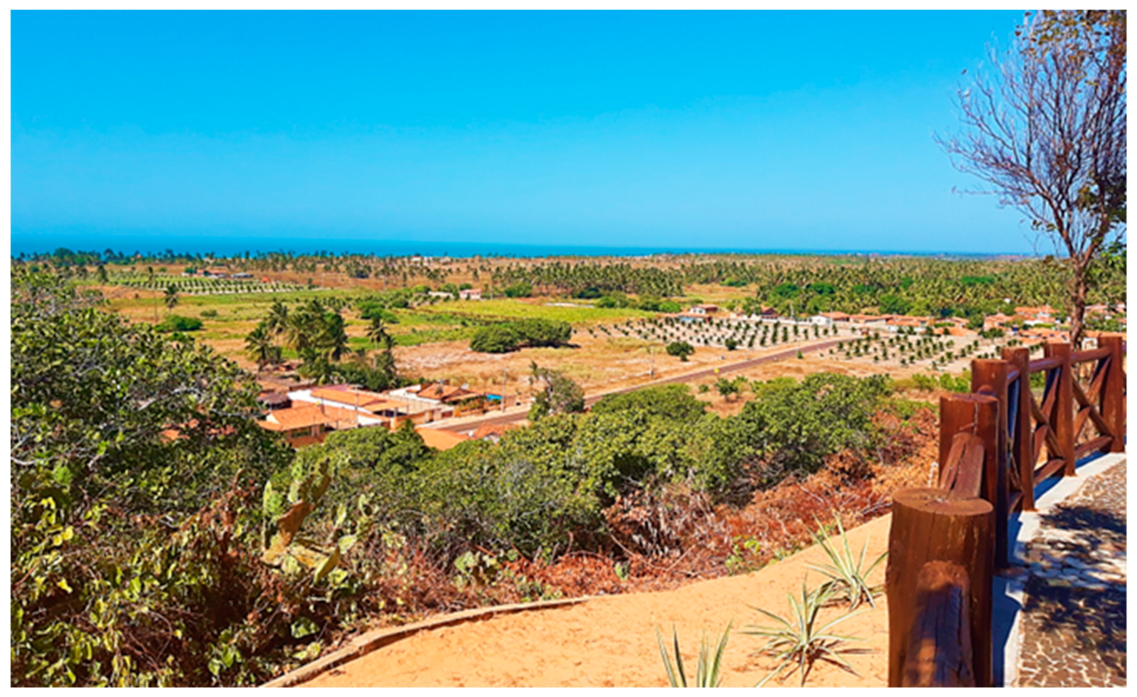
| EPA Dunas do Rosado | Municipality of Porto do Mangue (Rio Grande do Norte) | Decree n°. 27,695 of 21 February 2018 | Area of relevant geological interest with geomorphologic prominence with the presence of cliffs, dunes, estuaries, domes, hypersaline deserts, and areas of magmatism. |
| SDR Ponta do Tubarão | Municipality of Macau and Guamaré (Rio Grande do Norte) | State Law n° 8.349 of 18 July 2003 | Area of relevant geomorphological interest, mainly due to the presence of a complex estuarine system Ponta do Tubarão with fluvial-marine depositions that occur in the geoforms of spit, barrier island, sandbars, and beaches. |
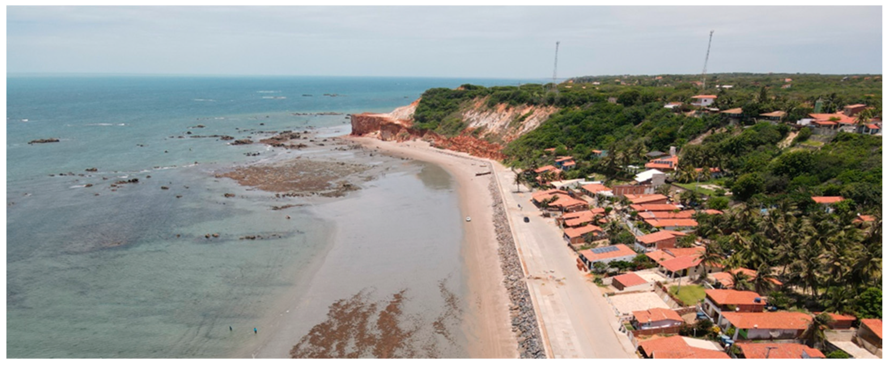
| EPA da Ponta Grossa | Municipality of Icapuí (Ceará) | Municipal Law n° 262/98 of 8 April 1998 | Area of relevant geomorphologic interest with emphasis on the presence of escarpments, boarders, mobile dunes, viewpoints, beaches, sandy banks, and paleocliffs. |
| EPA do Manguezal da Barra Grande | Municipality of Icapuí (Ceará) | Municipal Law No. 634/14 of 25 February 2014 | An area with relevant geomorphological interest due to the presence of the Barra Grande estuarine system, estuarine plains, estuary, and marine terraces. |
| EPA Berçários da Vida Marinha | Municipality of Icapuí (Ceará) | Municipal Law No. 890/2021 of 15 December 2021 | An area of relevant geomorphologic interest, with an emphasis on the presence of escarpments, tableland, mobile dunes, viewpoints, beaches, and sandy banks. |
| Criteria | Sub-Criteria | Indicators | Points |
|---|---|---|---|
| Natural Vulnerability | Active processes | No active processes affect the geosite | 0 |
| One active process affects the geosite episodically | 1 | ||
| One active process affects the geosite continuously or seasonally | 2 | ||
| Two or more active processes affect the geosite | 3 | ||
| Proximity | No possibility of degradation | 0 | |
| One possible active process in proximity of the geosite | 1 | ||
| Two possible active processes in proximity of the geosite | 2 | ||
| More than two active processes in proximity of the geosite | 3 | ||
| Anthropogenic Vulnerability | Economic interest | No geodiversity elements of economic interest | 0 |
| The geosite has an element of geodiversity of economic interest | 1 | ||
| The geosite has two elements of geodiversity of economic interest | 2 | ||
| The geosite has more than two elements of geodiversity of economic interest | 3 | ||
| Private Interest | No geodiversity elements of private interest | 0 | |
| The geosite has a collectible element of geodiversity for private interest | 1 | ||
| The geosite has two collectible geodiversity elements of private interest | 2 | ||
| The geosite has more than two elements of geodiversity collectible for private interest | 3 | ||
| Public Use | Legal protection | The geosite is protected for its geoheritage | 0 |
| The geosite is inside a protected natural area | 1 | ||
| The geosite is inside an area protected for other values (historical, cultural, etc.) | 2 | ||
| The geosite is not in a protected area | 3 | ||
| Human proximity | The geosite is located less than 100 m from a potential degradation activity | 3 | |
| The geosite is located less than 500 m from a potential degradation activity | 2 | ||
| The geosite is located less than 1 km from a potential degradation activity | 1 | ||
| The geosite is located more than 1 km from a potential degradation activity | 0 | ||
| Accessibility | The geosite is located less than 100 m from a paved road and bus parking space | 3 | |
| The geosite is located less than 100 m from a paved road | 2 | ||
| The geosite is located less than 100 m from a gravel road or between 100 and 500 m from a paved road | 1 | ||
| The geosite is located more than 100 m from a gravel road or more than 500 m from a paved road/no direct access | 0 | ||
| Population density | The geosite is not located near human occupation | 0 | |
| The geosite is located in a village or town in the rural area of a city | 1 | ||
| The geosite is located in the urban area of a city | 2 | ||
| The geosite is located in a city considered to be a regional center | 3 | ||
| Physical protection | Geosite has no protection | 3 | |
| Geosite with structure for tourists, but without physical protection of the geoheritage | 2 | ||
| Geosite with physical protection but without structure for tourists | 1 | ||
| Geosite with physical protection of geoheritage features and structure for tourists | 0 | ||
| Degrading use | No degradation from public use | 0 | |
| One element of degradation | 1 | ||
| Two elements of degradation | 2 | ||
| More than two elements of degradation | 3 | ||
| Control of access | No control at all | 3 | |
| The geosite is monitored by one method of control | 2 | ||
| The geosite is monitored by two methods of control | 1 | ||
| the geosite is monitored by more than two methods of control | 0 |
| Criteria | Partial Score | Total Score | Total Score on Degradation Risk | Risk Level |
|---|---|---|---|---|
| Natural Vulnerability | 0–6 | 0–33 | 0–7 | low |
| Anthropogenic Vulnerability | 0–6 | >7 ≤ 15 | medium | |
| Public Use | 0–21 | >15 ≤ 25 | high | |
| >25 | Very high |
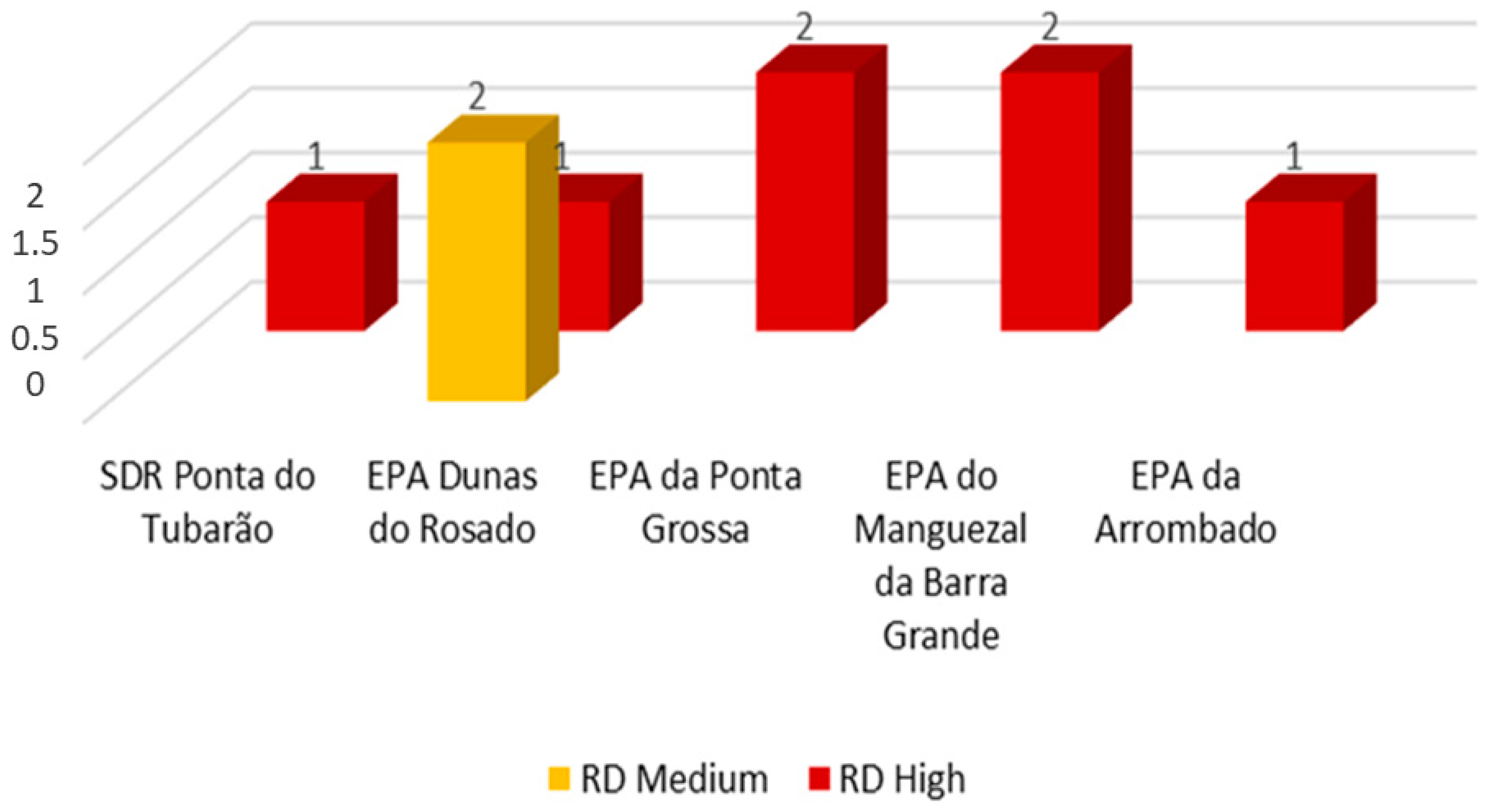
| Geosite | STATE | Natural Vulnerability | Anthropic Vulnerability | Public Use | Risk of Degradation | |||||||||||
|---|---|---|---|---|---|---|---|---|---|---|---|---|---|---|---|---|
| A1 | A2 | Total | B1 | B2 | Total | C1 | C2 | C3 | C4 | C5 | C6 | C7 | Total | |||
| Ponta do Tubarão estuary | RN | 0 | 1 | 1 | 3 | 0 | 3 | 1 | 3 | 3 | 1 | 3 | 3 | 3 | 17 | 21 |
| Rosado Cliffs | RN | 2 | 0 | 2 | 1 | 0 | 1 | 1 | 2 | 2 | 1 | 3 | 0 | 3 | 12 | 15 |
| Dunas do Rosado | RN | 2 | 1 | 3 | 1 | 0 | 1 | 1 | 2 | 2 | 1 | 3 | 0 | 3 | 12 | 16 |
| Ponta do Mel cliffs | RN | 0 | 1 | 1 | 1 | 0 | 0 | 1 | 0 | 1 | 1 | 2 | 0 | 3 | 8 | 10 |
| Retirinho site | CE | 3 | 0 | 3 | 1 | 0 | 1 | 1 | 0 | 1 | 1 | 3 | 3 | 3 | 12 | 16 |
| Ponta Grossa beach | CE | 3 | 0 | 3 | 1 | 0 | 1 | 1 | 3 | 3 | 1 | 3 | 3 | 3 | 17 | 21 |
| Redonda/Peroba beachs | CE | 2 | 0 | 2 | 1 | 0 | 1 | 1 | 3 | 3 | 1 | 3 | 3 | 3 | 17 | 20 |
| Picos/Vila Nova beachs | CE | 3 | 0 | 3 | 1 | 0 | 1 | 1 | 3 | 3 | 1 | 3 | 3 | 3 | 17 | 21 |
| Serra do Mar viewpoint | CE | 0 | 0 | 0 | 1 | 0 | 1 | 1 | 3 | 3 | 2 | 3 | 3 | 3 | 18 | 19 |
| Requenguela beach | CE | 0 | 0 | 0 | 2 | 0 | 2 | 1 | 3 | 3 | 1 | 3 | 2 | 3 | 16 | 18 |
| Icapuí viewpoint | CE | 0 | 0 | 0 | 2 | 0 | 2 | 1 | 3 | 3 | 2 | 3 | 3 | 3 | 18 | 20 |
| Manibu beach | CE | 0 | 1 | 1 | 0 | 0 | 0 | 1 | 3 | 3 | 1 | 3 | 3 | 3 | 17 | 18 |
 ; High
  .
.| Geosite | Scientific Value 1 | Aesthetic Value 1 | Risk of Degradation |
|---|---|---|---|
| Ponta do Tubarão estuary | 25 | 16 | 21 |
| Rosado Cliffs | 25 | 17 | 15 |
| Dunas do Rosado | 24 | 16 | 16 |
| Ponta do Mel cliffs | 22 | 17 | 10 |
| Retirinho site | 26 | 12 | 16 |
| Ponta Grossa beach | 25 | 19 | 21 |
| Redonda/Peroba beachs | 24 | 12 | 20 |
| Picos/Vila Nova beachs | 24 | 16 | 21 |
| Serra do Mar viewpoint | 17 | 15 | 19 |
| Requenguela beach | 25 | 16 | 18 |
| Icapuí viewpoint | 17 | 15 | 20 |
| Manibu beach | 19 | 9 | 18 |


Disclaimer/Publisher’s Note: The statements, opinions and data contained in all publications are solely those of the individual author(s) and contributor(s) and not of MDPI and/or the editor(s). MDPI and/or the editor(s) disclaim responsibility for any injury to people or property resulting from any ideas, methods, instructions or products referred to in the content. |
© 2023 by the authors. Licensee MDPI, Basel, Switzerland. This article is an open access article distributed under the terms and conditions of the Creative Commons Attribution (CC BY) license (https://creativecommons.org/licenses/by/4.0/).
Share and Cite
Rabelo, T.O.; Diniz, M.T.M.; de Araújo, I.G.D.; de Oliveira Terto, M.L.; Queiroz, L.S.; Araújo, P.V.d.N.; Pereira, P. Risk of Degradation and Coastal Flooding Hazard on Geoheritage in Protected Areas of the Semi-arid Coast of Brazil. Water 2023, 15, 2564. https://doi.org/10.3390/w15142564
Rabelo TO, Diniz MTM, de Araújo IGD, de Oliveira Terto ML, Queiroz LS, Araújo PVdN, Pereira P. Risk of Degradation and Coastal Flooding Hazard on Geoheritage in Protected Areas of the Semi-arid Coast of Brazil. Water. 2023; 15(14):2564. https://doi.org/10.3390/w15142564
Chicago/Turabian StyleRabelo, Thiara Oliveira, Marco Túlio Mendonça Diniz, Isa Gabriela Delgado de Araújo, Maria Luiza de Oliveira Terto, Larissa Silva Queiroz, Paulo Victor do Nascimento Araújo, and Paulo Pereira. 2023. "Risk of Degradation and Coastal Flooding Hazard on Geoheritage in Protected Areas of the Semi-arid Coast of Brazil" Water 15, no. 14: 2564. https://doi.org/10.3390/w15142564