You might also like
- AIR CRASH INVESTIGATIONS - THE BOEING 737 MAX DISASTER PART 1 - The Crash of Lion Air Flight 610From EverandAIR CRASH INVESTIGATIONS - THE BOEING 737 MAX DISASTER PART 1 - The Crash of Lion Air Flight 610No ratings yet
- Airport Cust Service Sem2-AODocument37 pagesAirport Cust Service Sem2-AOrajmercuryNo ratings yet
- Tissue Classification by Wavelet Modified Generic Fourier Descriptor and Their Recognition Using Hybrid CorrelatorDocument2 pagesTissue Classification by Wavelet Modified Generic Fourier Descriptor and Their Recognition Using Hybrid CorrelatorPurie DisanaaSiiniNo ratings yet
- List of Volcanoes in Uganda - WikipediaDocument5 pagesList of Volcanoes in Uganda - Wikipediamwimaandrew2No ratings yet
- Airspace Infringement - NAA and ANSP Links 06082018Document4 pagesAirspace Infringement - NAA and ANSP Links 06082018smdj1975No ratings yet
- WED LogDocument6 pagesWED LogGuilherme KaiserNo ratings yet
- Daftar Pustaka PKNDocument2 pagesDaftar Pustaka PKNNafil DanurNo ratings yet
- 3000 Dork Google - AOCDocument180 pages3000 Dork Google - AOCMobile legends funnyNo ratings yet
- RealtekDocument8 pagesRealtekSeema ChauhanNo ratings yet
- Bibliography: file:///C:/Users/Orthi/Downloads/erwin2008 PDFDocument2 pagesBibliography: file:///C:/Users/Orthi/Downloads/erwin2008 PDFDitiya AparajitaNo ratings yet
- Bibliography: file:///C:/Users/Orthi/Downloads/erwin2008 PDFDocument2 pagesBibliography: file:///C:/Users/Orthi/Downloads/erwin2008 PDFDitiya AparajitaNo ratings yet
- NewDocument7 pagesNewD5 flameNo ratings yet
- TELEFONICADocument1 pageTELEFONICAAyadel Ingenieros AyadelNo ratings yet
- SDDFSD FsdfsdfsfsfsfsfsdfsfsfsDocument2 pagesSDDFSD FsdfsdfsfsfsfsfsdfsfsfsJorge Luis Chavez AlejosNo ratings yet
- SDSDDocument2 pagesSDSDJorge Luis Chavez AlejosNo ratings yet
- ReferenceDocument5 pagesReferenceLim Suo HuiNo ratings yet
- Remote Desktop Redirected PrinterDocument1 pageRemote Desktop Redirected PrinterMuhammad NurhadiNo ratings yet
- B-2 Stealth BomberDocument18 pagesB-2 Stealth BomberGrapes als Priya67% (3)
- Link de Descargas FSXDocument10 pagesLink de Descargas FSXHorace GomezNo ratings yet
- Anr Sys Trace File 1676382046248Document116 pagesAnr Sys Trace File 1676382046248tao ouyangNo ratings yet
- Links Favoritos 2022Document1 pageLinks Favoritos 2022korteturtoNo ratings yet
- 2Document6 pages2Ayush nemaNo ratings yet
- Shitface (/de Ne - Php?term Shitface) : (/add - PHP) (/random - PHP (/users - PHPDocument8 pagesShitface (/de Ne - Php?term Shitface) : (/add - PHP) (/random - PHP (/users - PHPstocaNo ratings yet
- Tree Cutting Permit RequirementsDocument3 pagesTree Cutting Permit RequirementsMichael RojasNo ratings yet
- Vuelos Mexico EscosiaDocument2 pagesVuelos Mexico EscosiaAlfredo Rosas 21No ratings yet
- Link BMKG AirDocument8 pagesLink BMKG AirEko YuliantoNo ratings yet
- Operation and Maintenance of E & M Installations of Terminal Building and City Side Area at Dibrugarh Airport. - AIRPORTS AUTHORITY OF INDIADocument1 pageOperation and Maintenance of E & M Installations of Terminal Building and City Side Area at Dibrugarh Airport. - AIRPORTS AUTHORITY OF INDIANexus BroNo ratings yet
- Oetut6b RefDocument1 pageOetut6b RefPrithivi RajNo ratings yet
- Important Coding Questions LinkDocument94 pagesImportant Coding Questions Linkvaibhav dixit100% (1)
- LicDocument1 pageLicDarius SSNo ratings yet
- Link'uriDocument1 pageLink'uriAlina ManduNo ratings yet
- AirPods Pro - 20230927 - 235628Document9 pagesAirPods Pro - 20230927 - 235628josechecho2007No ratings yet
- Enginners Web SitesDocument9 pagesEnginners Web Siteschsiva_powerNo ratings yet
- DownloadDocument21 pagesDownloadriandayNo ratings yet
- C Best BooksDocument1 pageC Best BooksIonut IonutNo ratings yet
- Bot de DavidDocument44 pagesBot de DavidDanang JockerNo ratings yet
- CitationsDocument1 pageCitationsChristel Jane ElviniaNo ratings yet
- Bknp 192.168.1.0 255.255.255.0 192.168.1.1 208.67.222.222: Cấu hình DHCP ServerDocument3 pagesBknp 192.168.1.0 255.255.255.0 192.168.1.1 208.67.222.222: Cấu hình DHCP ServerDinh Hoai KhanhNo ratings yet
- Trace - 2020-03-17 03 - 55 - 00 277Document17 pagesTrace - 2020-03-17 03 - 55 - 00 277Mh PeiserNo ratings yet
- Last Crash LogDocument1 pageLast Crash LogCecilia RodriguezNo ratings yet
- Calcul ArbreDocument1 pageCalcul ArbreEthelNo ratings yet
- Web GISDocument1 pageWeb GISAgus BudiluhurNo ratings yet
- Surat Prngalaman KerjaDocument231 pagesSurat Prngalaman KerjayermiayosmanrampaNo ratings yet
- 20Document9 pages20PiNo ratings yet
- Crash 2024 02 02 08 55 20Document6 pagesCrash 2024 02 02 08 55 20Cássio Eduardo GrovermannNo ratings yet
- Implementation of The Air Traffic Flow Management (ATFM) inDocument15 pagesImplementation of The Air Traffic Flow Management (ATFM) inLoshanNo ratings yet
- Com.b 2 Winc - AmedigitalDocument12 pagesCom.b 2 Winc - AmedigitalCarlos EduardoNo ratings yet
- New Text DocumentDocument131 pagesNew Text DocumentCaibar AlexiaNo ratings yet
- WeatherDocument6 pagesWeatherionut_bordeianu5534No ratings yet
- 19:22:05Document334 pages19:22:05yamileth valenciaNo ratings yet
- UntitledDocument1 pageUntitledVIVIANA ALONDRA AGUILAR CARRANZANo ratings yet
- Crash 2023 10 01 13 37 25Document6 pagesCrash 2023 10 01 13 37 25M Irsad Husein SiregarNo ratings yet
- Electronic SourcesDocument2 pagesElectronic SourcesChenly RocutanNo ratings yet
- DCStudio ProdDocument14 pagesDCStudio ProdPayal Sethi KheraNo ratings yet
- Power Off Reset Reason BackupDocument4 pagesPower Off Reset Reason BackupVanegas De AngelNo ratings yet
- Robosot Parking Setting Up Guide: Arif RahmanDocument18 pagesRobosot Parking Setting Up Guide: Arif Rahmanamakil76No ratings yet
- Worker DocumentsDocument13 pagesWorker DocumentslearningNo ratings yet
- LinksDocument1 pageLinksKarinaAmparoCaballeroLopezNo ratings yet
- New C Programing NotesDocument74 pagesNew C Programing NotesMahesh RaikhelkarNo ratings yet
- List No. 02 - ATC (Advertisement No. 07-2023)Document1 pageList No. 02 - ATC (Advertisement No. 07-2023)Muhammad AliNo ratings yet
- CAA Finance Internship ReportDocument20 pagesCAA Finance Internship ReportNabeel Raja100% (4)
- Oil N Gas AddressesDocument8 pagesOil N Gas AddressesHAFIZ IMRAN AKHTERNo ratings yet
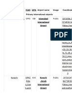
- List of Airports Codes in PakistanDocument37 pagesList of Airports Codes in Pakistansufyanbhai13cNo ratings yet
- Authorized Agents: T-: 92 21 4530807, 92 21 4315209 F-: 92 21-4315186 E-Mail:, WebsiteDocument5 pagesAuthorized Agents: T-: 92 21 4530807, 92 21 4315209 F-: 92 21-4315186 E-Mail:, WebsiteTariq Hussain KhanNo ratings yet
- Etihad TicketDocument1 pageEtihad TicketMuhammad Faizan Khan0% (5)
- Air BlueDocument6 pagesAir BlueFarid Nawaz KhanNo ratings yet
- Advertisement No. 12-2023Document2 pagesAdvertisement No. 12-2023YASIR ALINo ratings yet
- Airblue Report EditedDocument16 pagesAirblue Report EditedMaria Mohammed100% (1)
- AIR TRAFFIC CONTROL TOWER and Terminal BuildingDocument5 pagesAIR TRAFFIC CONTROL TOWER and Terminal BuildingYeyo NainuNo ratings yet
- PIA ProjectDocument27 pagesPIA Projectahsenali10053% (15)
- Eligible Candidates For ATC AssistantsDocument56 pagesEligible Candidates For ATC AssistantsmuzzamilNo ratings yet
- PIA's Flight PK-8303 Crash Analyis (Disaster Management) PDFDocument8 pagesPIA's Flight PK-8303 Crash Analyis (Disaster Management) PDFaleem khanNo ratings yet
- Pakistan International Airlines CorporationDocument16 pagesPakistan International Airlines CorporationMauhammad NajamNo ratings yet
- Airport Planning and Operations: A Practical OverviewDocument88 pagesAirport Planning and Operations: A Practical OverviewArif SamoonNo ratings yet
- Pakistan Civil Aviation Authority Presentation ReportDocument24 pagesPakistan Civil Aviation Authority Presentation ReportSamreen JawaidNo ratings yet
- Study AirCargo PakistanDocument67 pagesStudy AirCargo PakistanUmais QureshiNo ratings yet
- List of Heritage BuildingsDocument11 pagesList of Heritage BuildingsNaval Vaswani50% (2)
- Air Blue Concept PaperDocument10 pagesAir Blue Concept PaperNašar RähmänNo ratings yet
- Inv 0128 22Document1 pageInv 0128 22BILAL FAROOQUINo ratings yet
- Internship Report On PCAA AIIAP PDFDocument28 pagesInternship Report On PCAA AIIAP PDFUsama SaoodNo ratings yet
- Pakistan International Airlines ProjectDocument19 pagesPakistan International Airlines Project✬ SHANZA MALIK ✬100% (2)
- NESPAK: Pakistan's Leading Consultants: Airport Planning & DesigningDocument1 pageNESPAK: Pakistan's Leading Consultants: Airport Planning & DesigningAbdul RafaeNo ratings yet
- Pia and Air Blue Research MethodologyDocument18 pagesPia and Air Blue Research MethodologyHaroon AhmedNo ratings yet
- 15 A-Summ (Jan-2015)Document7 pages15 A-Summ (Jan-2015)Qaral ShamsNo ratings yet
- Karachi HistoryDocument7 pagesKarachi HistoryIrfan SayedNo ratings yet
- Eligible Candidates For Asst. Director RFFSDocument80 pagesEligible Candidates For Asst. Director RFFSmuzzamilNo ratings yet
- 2021 09 10T12 57 36 470agy75Document1 page2021 09 10T12 57 36 470agy75nazish aliNo ratings yet
- PIA AssignmentDocument13 pagesPIA AssignmentBabur FarrukhNo ratings yet
- Presentation On AirblueDocument59 pagesPresentation On AirblueIbrahim zamanNo ratings yet