SlideShare a Scribd company logo
1 of 65
Download to read offline
General Information
Location: RIO DE JANEIRO BRA
ICAO/IATA: SBGL / GIG
Lat/Long: S22° 48.60', W043° 15.03'
Elevation: 28 ft
Airport Use: Joint-Use
Daylight Savings: Observed
UTC Conversion: +3:00 = UTC
Magnetic Variation: 23.0° W
Fuel Types: Jet
Customs: Yes
Airport Type: IFR
Landing Fee: No
Control Tower: Yes
Jet Start Unit: No
LLWS Alert: No
Beacon: Yes
Sunrise: 0830 Z
Sunset: 2142 Z
Runway Information
Runway: 10
Length x Width: 13123 ft x 148 ft
Surface Type: concrete
TDZ-Elev: 16 ft
Lighting: Edge, ALS, Centerline, TDZ
Stopway: 197 ft
Runway: 15
Length x Width: 10433 ft x 154 ft
Surface Type: asphalt
TDZ-Elev: 16 ft
Lighting: Edge, ALS
Runway: 33
Length x Width: 10433 ft x 154 ft
Surface Type: asphalt
TDZ-Elev: 11 ft
Lighting: Edge
Runway: 28
Length x Width: 13123 ft x 148 ft
Surface Type: concrete
TDZ-Elev: 28 ft
Lighting: Edge, ALS, Centerline, TDZ
Stopway: 197 ft
Communication Information
ATIS: 127.600
Galeao Tower: 118.200
Galeao Tower: 118.000
Galeao Ground: 121.650
Galeao Clearance Delivery: 121.000
Macae Approach: 119.200
Macae Approach: 120.000
Sao Paulo Approach: 120.850
Sao Paulo Approach: 123.900
Sao Paulo Approach: 124.700
Sao Paulo Approach: 125.600
Sao Paulo Approach: 129.000
Macae Approach: 129.300
Sao Paulo Approach: 134.900
Rio Control: 120.550 TCA
Galeao Operations: 122.500 Military
Galeao Operations: 121.000
Rio Control: 134.950 TCA
Rio Control: 134.400 TCA
Rio Control: 133.300 TCA
Rio Control: 132.975 TCA Secondary
Rio Control: 129.800 TCA
Rio Control: 129.200 TCA
Rio Control: 128.900 TCA
Rio Control: 126.200 TCA
Rio Control: 125.950 TCA
Rio Control: 124.950 TCA
Rio Control: 121.250 TCA
Rio Control: 120.750 TCA
Rio Control: 119.725 TCA
Rio Control: 119.350 TCA
Rio Control: 119.000 TCA
Curitiba ACC: 124.000
Curitiba ACC: 125.350
Curitiba ACC: 127.050
Curitiba ACC: 128.250
Curitiba ACC: 128.400
Curitiba ACC: 133.400
Curitiba ACC: 133.600
General Information
Location: RIO DE JANEIRO BRA
ICAO/IATA: SBGL / GIG
Lat/Long: S22° 48.60', W043° 15.03'
Elevation: 28 ft
Airport Use: Joint-Use
Daylight Savings: Observed
UTC Conversion: +3:00 = UTC
Magnetic Variation: 23.0° W
Fuel Types: Jet
Customs: Yes
Airport Type: IFR
Landing Fee: No
Control Tower: Yes
Jet Start Unit: No
LLWS Alert: No
Beacon: Yes
Sunrise: 0830 Z
Sunset: 2142 Z
Runway Information
Runway: 10
Length x Width: 13123 ft x 148 ft
Surface Type: concrete
TDZ-Elev: 16 ft
Lighting: Edge, ALS, Centerline, TDZ
Stopway: 197 ft
Runway: 15
Length x Width: 10433 ft x 154 ft
Surface Type: asphalt
TDZ-Elev: 16 ft
Lighting: Edge, ALS
Runway: 33
Length x Width: 10433 ft x 154 ft
Surface Type: asphalt
TDZ-Elev: 11 ft
Lighting: Edge
Runway: 28
Length x Width: 13123 ft x 148 ft
Surface Type: concrete
TDZ-Elev: 28 ft
Lighting: Edge, ALS, Centerline, TDZ
Stopway: 197 ft
Airport Information For SBGL
Printed on 27 Jan 2018
Page 1
(c) JEPPESEN SANDERSON, INC., 2018, ALL RIGHTS RESERVED
jep=JEPPESEN
JeppView for Windows
General Information
Location: RIO DE JANEIRO BRA
ICAO/IATA: SBGL / GIG
Lat/Long: S22° 48.60', W043° 15.03'
Elevation: 28 ft
Airport Use: Joint-Use
Daylight Savings: Observed
UTC Conversion: +3:00 = UTC
Magnetic Variation: 23.0° W
Fuel Types: Jet
Customs: Yes
Airport Type: IFR
Landing Fee: No
Control Tower: Yes
Jet Start Unit: No
LLWS Alert: No
Beacon: Yes
Sunrise: 0830 Z
Sunset: 2142 Z
Runway Information
Runway: 10
Length x Width: 13123 ft x 148 ft
Surface Type: concrete
TDZ-Elev: 16 ft
Lighting: Edge, ALS, Centerline, TDZ
Stopway: 197 ft
Runway: 15
Length x Width: 10433 ft x 154 ft
Surface Type: asphalt
TDZ-Elev: 16 ft
Lighting: Edge, ALS
Runway: 33
Length x Width: 10433 ft x 154 ft
Surface Type: asphalt
TDZ-Elev: 11 ft
Lighting: Edge
Runway: 28
Length x Width: 13123 ft x 148 ft
Surface Type: concrete
TDZ-Elev: 28 ft
Lighting: Edge, ALS, Centerline, TDZ
Stopway: 197 ft
Communication Information
ATIS: 127.600
Galeao Tower: 118.200
Galeao Tower: 118.000
Galeao Ground: 121.650
Galeao Clearance Delivery: 121.000
Macae Approach: 119.200
Macae Approach: 120.000
Sao Paulo Approach: 120.850
Sao Paulo Approach: 123.900
Sao Paulo Approach: 124.700
Sao Paulo Approach: 125.600
Sao Paulo Approach: 129.000
Macae Approach: 129.300
Sao Paulo Approach: 134.900
Rio Control: 120.550 TCA
Galeao Operations: 122.500 Military
Galeao Operations: 121.000
Rio Control: 134.950 TCA
Rio Control: 134.400 TCA
Rio Control: 133.300 TCA
Rio Control: 132.975 TCA Secondary
Rio Control: 129.800 TCA
Rio Control: 129.200 TCA
Rio Control: 128.900 TCA
Rio Control: 126.200 TCA
Rio Control: 125.950 TCA
Rio Control: 124.950 TCA
Rio Control: 121.250 TCA
Rio Control: 120.750 TCA
Rio Control: 119.725 TCA
Rio Control: 119.350 TCA
Rio Control: 119.000 TCA
Curitiba ACC: 124.000
Curitiba ACC: 125.350
Curitiba ACC: 127.050
Curitiba ACC: 128.250
Curitiba ACC: 128.400
Curitiba ACC: 133.400
Curitiba ACC: 133.600
Airport Information For SBGL
Printed on 27 Jan 2018
Page 2
(c) JEPPESEN SANDERSON, INC., 2018, ALL RIGHTS RESERVED
jep=JEPPESEN
JeppView for Windows
SANTACRUZ
RASA
AFONSOS
CAXIAS
ILHA
SCRVOR
CAXNDB
IHNDB
YLANDB
AFSNDB
D20
D40
D60
33
0^
0^
^
090^ 210^
1
50^
210^
^
40
180^
00^
2
270^
D40
D60
D60
D40
JobimIntl
SB(P)-307
SB(P)-308
SB(P)-320
SB(P)-331
SB(P)-302
SB(P)
-319
D80D80
AptElevTranslevel:ByATC
28'
AltSet:hPaTransalt:7000'
JEPPESEN
COMMSFAILURE
1.SetTranspondercode7600;and
2.Followcommunicationfailure
procedureonrelevantSTAR
and/orInstrumentApproach
Chart.
3JAN14
119.0119.35120.55
129.2129.8
126.2128.9
133.3135.6121.5
PIRAI
115.0PAIPAID
MARICA
114.8MIAMIAD
PORTO
114.6PCXPCXD
CAXIAS
112.3CXICXID
(H)
NOVA
215NOANOA
PAIOL
415PPPP
CXIR-278
CXI
R-292
CXI
CXI
CXI
R-298
PAIR-290
R-343
2600
4400
6600
5300
3900
2000
FL090
4000
3100
2400
2700
3500
4200
4700
3500
4400
5300
5000
7000
FL085FL095
FL095
FL085
6400
4900
2100
PCX R-360 MIAR-286MIAR-291
MIA
R-308
MIAR-314
7000
2000
4400
17002000
3000
2500
4500
3100
9069'
22-00
22-30
23-00
23-30
24-00
42-0042-3043-0043-3044-0044-30
NOA298^
NOA098^
NOA103^
21 NM
R-278
10 020304050 10
1.Charttobeusedforcross-checkingofaltitudesassignedwhile
underradarcontrol.2.DistancesarereferencedtoCXIVOR.
PP028^
NOA
228^
PP 016^
PAIR-102
2600
*RIOControl(Approach)(R)
060
3
Galeao
-AntonioC
D20
INTERVALS
CONTOUR
2000
8000
4000
6000
10-1R
SBGL/GIG
.RADAR.MINIMUM.ALTITUDES.
Newchart.|JEPPESEN,2014.ALLRIGHTSRESERVED.
GALEAO-ANTONIOCJOBIMINTL
RIODEJANEIRO,BRAZIL
CHANGES:
Printed from JeppView for Windows 5.3.0.0 on 27 Jan 2018; Terminal chart data cycle 01-2018 (Expired); Notice: After 25 Jan 2018, 0000Z, this chart may no longer be valid
COMMSLOSTLOST
COMMS COMMSLOST COMMSLOST COMMSLOST COMMSLOST COMMSLOST COMMSLOST
COMMSCOMMSLOST
ALDEIA
112.1 ADAADAS22 48.8 W042 05.7
D
MOLSU
S21 50.4
W042 12.3
CHANGES:
Apt Elev
28'
10-2
SBGL/GIG JEPPESEN
.RNAV.STAR.
127.6
Alt Set: hPa Trans level: By ATC Trans alt: 7000'
2. RNAV 1: ATS surveillance system required.
1. RNAV 1 or RNP 1.
operative: ADA, CXI, and PCX.
3. For aircraft not equipped with GNSS, the following DME must be
GALEAO-ANTONIO
CARLOS JOBIM INTL
RIO DE JANEIRO, BRAZIL
MSA ARP
[DIVR1A]
090^
270^
160^
FL095
6300'
5000'
1
1
within 10 NM
1 5500'
TRANSITIONS
ADA
MOLSU
MAINTAIN 308^ course to DIVRO.
MAINTAIN 232^ course to DIVRO.
RWY
28
33
ROUTING
procedure authorized by ATC or, on heading 150^, EXPECT vectors to final approach.
Rwy 28:
Complete arrival until KETUX and execute procedure authorized by ATC.
Rwy 33:
Complete arrival until OPSID and execute procedure authorized by ATC.
5000' until CXI 25 DME. Then, turn RIGHT to intercept final approach.
Or, if under vectors on heading 150^, MAINTAIN heading, minimum altitude
34.9
9.9
ADA
232^
308^
277^
234^
277^
097^
47.3
4.49.7
9.0
MOLSU
150^hdg
S22 43.3
KETUX
W042 56.9
S22 51.9
OPSID
W043 02.4
S22 39.6
DIVRO
W042 42.1
At or above
FL080
At or above
5000'
CAXIAS
112.3 CXICXIS22 49.0 W043 15.6
D
At or above
5000'
At or below
7000'
Direct distance to Galeao-
Antonio Carlos Jobim Intl from:
KETUX 18 NM
OPSID 12 NM
| JEPPESEN, 2013, 2016. ALL RIGHTS RESERVED.
2 DEC 16
At DIVRO, MAINTAIN 277^ course to KETUX. Then, complete procedure authorized by ATC.
At DIVRO, MAINTAIN 277^ course to KETUX. Turn LEFT, course 234^ to OPSID. Then, complete
.Eff.8.Dec.
D-ATIS
DIVRO 1A RNAV ARRIVAL
Airport elevation.
NOT TO SCALE
Printed from JeppView for Windows 5.3.0.0 on 27 Jan 2018; Terminal chart data cycle 01-2018 (Expired); Notice: After 25 Jan 2018, 0000Z, this chart may no longer be valid
COMMSLOST
COMMSLOST COMMSLOST COMMSLOST COMMSLOST COMMSLOST COMMSLOST COMMSLOST
COMMSLOST
ALDEIA
112.1 ADAADAS22 48.8 W042 05.7
D
MOLSU
S21 50.4
W042 12.3
CHANGES:
Apt Elev
28'
SBGL/GIG JEPPESEN
.RNAV.STAR.
127.6
Alt Set: hPa Trans level: By ATC Trans alt: 7000'
2. RNAV 1: ATS surveillance system required.
1. RNAV 1 or RNP 1.
operating: ADA, CXI, and PCX.
3. For aircraft not equipped with GNSS, the following DME must be
GALEAO-ANTONIO
CARLOS JOBIM INTL
RIO DE JANEIRO, BRAZIL
MSA ARP
[DIVR1B]
090^
270^
160^
FL095
6300'
5000'
1
1
within 10 NM
1 5500'
TRANSITIONS
ADA
MOLSU
MAINTAIN 308^ course to DIVRO.
MAINTAIN 232^ course to DIVRO.
ROUTING
Complete arrival until VURUK and execute procedure authorized by ATC.
4000' until CXI 25 DME. Then, turn RIGHT to intercept final approach.
Or, if under vectors on heading 150^, MAINTAIN heading, minimum altitude
34.9
ADA
232^
308^
277^
277^
097^
47.3
4.49.7
9.0
MOLSU
150^hdg
KETUX
VURUK
DIVRO
CAXIAS
112.3 CXICXIS22 49.0 W043 15.6
D
At or above
5000'
At or below
7000'
D-ATIS
| JEPPESEN, 2016. ALL RIGHTS RESERVED.
DIVRO 1B RNAV ARRIVAL
10-2A .Eff.8.Dec.
(RWY 33)
At DIVRO, MAINTAIN 277^ course to KETUX. Turn LEFT, course 274^ to VURUK. Then, complete procedure
authorized by ATC or, on heading 150^, EXPECT vectors to final approach.
At or above
4000' 274^
7.2
At or above
FL090
Direct distance from VURUK to:
Galeao-Antonio Carlos
Jobim Intl 10 NM
2 DEC 16
N22 45.6
W043 04.2
S22 43.3
W042 56.9
S22 39.6
W042 42.1
At or above
FL080
Chart reindexed.
NOT TO SCALE
Printed from JeppView for Windows 5.3.0.0 on 27 Jan 2018; Terminal chart data cycle 01-2018 (Expired); Notice: After 25 Jan 2018, 0000Z, this chart may no longer be valid
COMMSLOST
COMMSLOST COMMSLOST COMMSLOST COMMSLOST COMMSLOST
COMMSLOST
ROPAS
S23 54.0
W044 14.5
ILTIT
S23 48.5
W044 02.2
ESORU
S23 01.8
W044 40.6
EPGIP
S22 52.3
W043 58.6
CHANGES:
Apt Elev
30'
SBGL/GIG JEPPESEN
GALEAO-ANTONIO
CARLOS JOBIM INTL 10-2B
RIO DE JANEIRO, BRAZIL
.RNAV.STAR.
ATIS
127.6
Alt Set: hPa Trans level: By ATC Trans alt: 7000'
[EPGI1A]
1. RNAV 1 or RNP 1.
2. RNAV 1: ATS surveillance system required.
3. For aircraft not equipped with GNSS, the following DME must be
operative: CXI, MIA, and SCR.
MSA ARP
090^
270^
160^
FL095
6300'
5000'
1
1
within 10 NM
1 5500'
TRANSITIONS
ESORU
AKNUB
KOLBI
MAINTAIN 098^ course to EPGIP.
ROUTING
025^
098^
098^
086^
ESORU
12.5
14.5
5.0
8.822.05.7
39.9
14.8
5.3 3.8
330^hdg
Direct distance from EGDUT to:
Galeao-Antonio Carlos
Jobim Intl 17 NM
098^
278^
W044 01.3
KABUK
S23 34.0
S22 47.4
GL~71
W043 37.6 S22 46.5
EGDUT
W043 33.6
At or above
FL090
At or above
FL120
At or below
FL210
At or above
FL210
At or below
FL230
278^
CAXIAS
112.3 CXICXIS22 49.0 W043 15.6
D
At or above
6300'205^
(RWY 15)
| JEPPESEN, 2013, 2016. ALL RIGHTS RESERVED.
086^
049^
086^
050^
266^
230^
28.5
40.0
KOLBI
AKNUB
W044 42.3
KOLBI
S24 06.6
AKNUB
S24 29.7
W044 34.4
MAINTAIN 086^ course to ILTIT. Turn LEFT course 025^ to EPGIP.
Complete arrival until EGDUT and execute procedure
authorized by ATC. Or, if under vectors on heading 330^,
MAINTAIN heading, minimum altitude 6300' until CXI 29 DME.
Then, turn RIGHT to intercept final approach.
1 JAN 16
EPGIP 1A RNAV
Chart reindexed.
.Eff.7.Jan.
MAINTAIN 049^ course to ROPAS. Turn RIGHT, course 086^ to ILTIT. Turn LEFT, course 025^ to
EPGIP.
At EPGIP, MAINTAIN 098^ course to EGDUT. Then, complete procedure authorized by ATC or, on heading
330^, EXPECT vectors to final approach.
NOT TO SCALE
Printed from JeppView for Windows 5.3.0.0 on 27 Jan 2018; Terminal chart data cycle 01-2018 (Expired); Notice: After 25 Jan 2018, 0000Z, this chart may no longer be valid
COMMSLOSTCOMMSLOSTCOMMSLOST
COMMSLOST COMMSLOST COMMSLOST COMMSLOST
COMMSLOSTCOMMSLOSTCOMMSLOST
ESORU
S23 01.8
W044 40.6
EPGIP
S22 52.3
W043 58.6
ILTIT
S23 48.5
W044 02.2
ROPAS
S23 54.0
W044 14.5
CHANGES:
Apt Elev
30'
SBGL/GIG JEPPESEN
.RNAV.STAR.
ATIS
127.6
Alt Set: hPa Trans level: By ATC Trans alt: 7000'
2. RNAV 1: ATS surveillance system required.
1. RNAV 1 or RNP 1.
operative: CXI, MIA, and SCR.
3. For aircraft not equipped with GNSS, the following DME must be
GALEAO-ANTONIO
CARLOS JOBIM INTL
RIO DE JANEIRO, BRAZIL
MSA ARP
[EPGI1A]
090^
270^
160^
FL095
6300'
5000'
1
1
within 10 NM
1 5500'
10-2C
TRANSITIONS
ESORU
AKNUB
KOLBI
MAINTAIN 098^ course to EPGIP.
ROUTINGRWY
28
33
Rwy 28:
Complete arrival until SEDBU and
execute procedure authorized by ATC.
Or, if under vectors on heading 100^,
MAINTAIN heading, minimum altitude
5000' until CXI 26 DME. Then, turn
RIGHT to intercept final approach.
Rwy 33:
Complete arrival until OPSID and
execute procedure authorized by ATC.
Or, if under vectors on heading 150^,
MAINTAIN heading, minimum altitude
5000' until CXI 25 DME. Then, turn
RIGHT to intercept final approach.
098^
098^
149^
086^
025^
098^
100^
150^
278^
278^
205^
hdg
hdg
39.9
21.2
19.3
11.4
15.9
5.722.08.8
5.0
14.5
12.5
ESORU
W044 01.3
KABUK
S23 34.0
IVTAL
S22 39.5
SEDBU
W043 04.2
S22 51.9
OPSID
W043 02.4
At or below
FL230
At or above
FL210
At or below
FL210
Between
FL130 & FL090
At or above
5000'
At or above
5000'
S22 42.4 W043 16.2
At or above
FL080
CAXIAS
112.3 CXICXIS22 49.0 W043 15.6
D
OPSID 12 NM
SEDBU 13 NM
Direct distance to Galeao-
Antonio Carlos Jobim Intl from:
| JEPPESEN, 2013, 2016. ALL RIGHTS RESERVED.
MAINTAIN 086^ course to ILTIT. Turn LEFT course 025^ to EPGIP.
S24 06.6
W044 42.3
KOLBI
086^
266^
AKNUB
S24 29.7
W044 34.4
050^
230^
049^
AKNUB40.0
28.5KOLBI086^
At or above
FL120
1 JAN 16 .Eff.7.Jan.
EPGIP 1A RNAV
Chart reindexed.
At EPGIP, MAINTAIN 098^ course to SEDBU. Then, complete procedure authorized by ATC or,
on heading 100^, EXPECT vectors to final approach.
At EPGIP, MAINTAIN 098^ course to IVTAL. Turn RIGHT, course 149^ to OPSID. Then,
complete procedure authorized by ATC or, on heading 150^, EXPECT vectors to final approach.
MAINTAIN 049^ course to ROPAS. Turn RIGHT course 086^ to ILTIT. Turn LEFT, course 025^ to
EPGIP.
NOT TO SCALE
Printed from JeppView for Windows 5.3.0.0 on 27 Jan 2018; Terminal chart data cycle 01-2018 (Expired); Notice: After 25 Jan 2018, 0000Z, this chart may no longer be valid
COMMS LOST
COMMSLOSTCOMMSLOSTCOMMSLOSTCOMMSLOSTCOMMSLOSTCOMMSLOST
COMMS
D103
MCA
115.9
MCA
D167
D127
D112
R278^
CAXIAS
112.3CXICXIS2249.0W04315.6
D
CHANGES:
Apt Elev
28'
SBGL/GIG JEPPESEN
.STAR.
GALEAO-ANTONIO
CARLOS JOBIM INTL
RIO DE JANEIRO, BRAZIL
10-2D
127.6
090^
270^
160^
FL095
6300'
5000'
1
1
within10NM
15500'
[EPGI1B]
ROUTING
byATCor,onheading330^,EXPECTvectorstofinalapproach.
MAINTAINMCAR-278toEGDUT.Then,completeprocedureauthorized
Alt Set: hPa Trans level: By ATC Trans alt: 7000'
CompletearrivaluntilEGDUTandexecuteprocedureauthorized
byATC.Or,ifundervectorsonheading330^,MAINTAINheading,
minimumaltitude6300'untilCXI29DME.Then,turnRIGHTto
interceptfinalapproach.
098^
098^39.9
14.8
9.1
278^
278^
Atorabove
6300'
Atorabove
FL090
EGDUT
D16.8CXI
ESORU
EPGIP
D79.5CXI
D39.9CXI
D25.4CXI330^hdg
DirectdistancefromEGDUTto:
Galeao-AntonioCarlos
JobimIntl17NM
MSACXIVOR (RWY 15)
| JEPPESEN, 2013, 2016. ALL RIGHTS RESERVED.
2 DEC 16 .Eff.8.Dec.
EPGIP 1B
S2301.8
W04440.6
S2252.3
W04358.6
S2246.5
W04333.6
Chart reindexed, airport elevation.
D-ATIS
NOTTOSCALE
Printed from JeppView for Windows 5.3.0.0 on 27 Jan 2018; Terminal chart data cycle 01-2018 (Expired); Notice: After 25 Jan 2018, 0000Z, this chart may no longer be valid
D74.7
D10.3
R278^
R329^
MCA
115.9
MCA
D86.1
D127
D167
COMMS LOSTCOMMS LOST
COMMSLOSTCOMMSLOSTCOMMSLOSTCOMMSLOSTCOMMSLOSTCOMMSLOST
COMMS COMMSLOST LOST
298^
CHANGES:
Apt Elev
28'
SBGL/GIG JEPPESEN
.STAR.
GALEAO-ANTONIO
CARLOS JOBIM INTL
RIO DE JANEIRO, BRAZIL
10-2E
127.6
090^
270^
160^
FL095
6300'
5000'
1
1
within10NM
15500'
[EPGI1B]
Alt Set: hPa Trans level: By ATC Trans alt: 7000'
S2301.8
W04440.6
S2252.3
W04358.6
MARICA
114.8MIAMIAS2258.0W04253.5
D
DirectdistancetoGaleao-
AntonioCarlosJobimIntlfrom:
RWY
28
33
ROUTING
MAINTAINMCAR-278toSEDBU.Then,completeprocedureauthorizedbyATCor,
onheading100^,EXPECTvectorstofinalapproach.
MAINTAINMCAR-278toIVTAL.TurnRIGHT,MIAR-329toOPSID.Then,complete
procedureauthorizedbyATCor,onheading150^,EXPECTvectorstofinalapproach.
Rwy28:
CompletearrivaluntilSEDBUandexecuteprocedureauthorizedby
Rwy33:
CompletearrivaluntilOPSIDandexecuteprocedureauthorizedby
MSACXIVOR
CAXIAS
112.3CXICXIS2249.0W04315.6
D
098^
098^
149^
39.9
21.2
19.315.9
11.4
278^
278^
100^
150^
hdg
hdg
Between
FL130&FL090
Atorabove
FL080
Atorabove
5000'
ESORU
EPGIP
D79.5CXI
D39.9CXI
S2242.4
W04316.2
IVTAL
S2239.5
W04304.2
SEDBU
S2251.9
W04302.4
OPSID
OPSID12NM
SEDBU13NM
D19.3CXI
D105MCA
ATC.Or,ifundervectorsonheading100^,MAINTAINheading,
ATC.Or,ifundervectorsonheading150^,MAINTAINheading,
minimumaltitude5000'untilCXI26DME.Then,turnRIGHTto
interceptfinalapproach.
minimumaltitude5000'untilCXI25DME.Then,turnRIGHTto
interceptfinalapproach.
| JEPPESEN, 2013, 2016. ALL RIGHTS RESERVED.
2 DEC 16
EPGIP 1B
.Eff.8.Dec.
Chart reindexed, airport elevation.
Atorabove
5000'
D-ATIS
NOTTOSCALE
Printed from JeppView for Windows 5.3.0.0 on 27 Jan 2018; Terminal chart data cycle 01-2018 (Expired); Notice: After 25 Jan 2018, 0000Z, this chart may no longer be valid
COMMSLOST
COMMSLOST COMMSLOST COMMSLOST LOST
COMMS
CHANGES:
Apt Elev
28'
SBGL/GIG JEPPESEN
GALEAO-ANTONIO
CARLOS JOBIM INTL 10-2F
RIO DE JANEIRO, BRAZIL
.RNAV.STAR.
127.6
Alt Set: hPa Trans level: By ATC Trans alt: 7000'
(RWY 10)
1. RNAV 1 or RNP 1.
2. RNAV 1: ATS surveillance system required.
3. For aircraft not equipped with GNSS, the following DME must be
operative: CXI, PAI, and SCR.
MSA ARP
090^
270^
160^
FL095
6300'
5000'
1
1
within 10 NM
1 5500'
Direct distance from DONGI to:
Galeao-Antonio Carlos
Jobim Intl 19 NM
086^
098^
025^
097^
14.5
5.0
8.820.9 5.0
6.011.7
39.9
131^
097^
11.9
205^
278^
W044 40.6
ESORU
S23 01.8
EPGIP
S22 52.3
W043 58.6
W044 14.5
ROPAS
S23 54.0 ILTIT
S23 48.5
W044 02.2
W044 01.3
KABUK
S23 34.0
W043 59.1
KUDSI
S22 59.2
W043 35.2
DONGI
S22 53.2
W043 46.6
VUSRA
S22 56.0
At or above
6300'At or above
FL080
At or above
FL120
At or below
FL210
At or above
FL210
At or below
FL230
ESORU 1A
086^
266^
W044 42.3
KOLBI
S24 06.6
086^
28.5KOLBI
049^
40.0
AKNUB
050^
230^
AKNUB
S24 29.7
W044 34.4
| JEPPESEN, 2013, 2016. ALL RIGHTS RESERVED.
TRANSITIONS
AKNUB
KOLBI
ROUTING
MAINTAIN 086^ course to ILTIT.
SID
ESORU 1A
ROPAS 1A
12.5
ROPAS
1A
MAINTAIN 049^ course to ROPAS. Turn RIGHT, course 086^ to ILTIT.
2 DEC 16 .Eff.8.Dec.
ESORU 1A [ESOR1A], ROPAS 1A [ROPA1A]
RNAV
MAINTAIN 098^ course to EPGIP. Turn RIGHT, course 131^ to VUSRA. Turn LEFT, course
097^ to DONGI. Then, complete procedure authorized by ATC.
At ILTIT, turn LEFT, course 025^ to KUDSI. Turn RIGHT, course 097^ to DONGI. Then,
complete procedure authorized by ATC.
Complete arrival until DONGI and
execute procedure authorized by ATC.
Chart reindexed, airport elevation.
D-ATIS
NOT TO SCALE
Printed from JeppView for Windows 5.3.0.0 on 27 Jan 2018; Terminal chart data cycle 01-2018 (Expired); Notice: After 25 Jan 2018, 0000Z, this chart may no longer be valid
COMMSLOSTLOST
COMMS COMMSLOST COMMSLOST COMMSLOST COMMSLOST COMMSLOST COMMSLOST
COMMSCOMMSLOST
CHANGES:
Apt Elev
28'
SBGL/GIG JEPPESEN
.RNAV.STAR.
127.6
Alt Set: hPa Trans level: By ATC Trans alt: 7000'
2. RNAV 1: ATS surveillance system required.
1. RNAV 1 or RNP 1.
operative: CXI, PAI, and PCX.
3. For aircraft not equipped with GNSS, the following DME must be
GALEAO-ANTONIO
CARLOS JOBIM INTL
RIO DE JANEIRO, BRAZIL
MSA ARP
090^
270^
160^
FL095
6300'
5000'
1
1
within 10 NM
1 5500'
10-2G
STAR
TODAB 1A
GIGSO 1A
RWY
10
15
LANDING
At UTBOM, complete procedure authorized by ATC.
Rwy 10:
Rwy 15:
Complete arrival until UTBOM and execute procedure authorized by ATC.
Complete arrival until NOA and execute procedure authorized by ATC.
Or, if under vectors on heading 275^, MAINTAIN heading, minimum altitude
6300' until CXI 25 DME. Then, turn LEFT to intercept final approach.
120^ 116^
148^
177^
8.7
6.7
2.4
19.0
5.1
TODAB 1A
177^
171^
177^
MAVGU
8.2
18.0
30.9
10.6
5.5
GIGSO1A
357^
357^
098^
052^
6.0
7.1
5.0
224^
278^
232^MOLSU18.1
27.9
10.0
12.6
13.9
MAVGU
S21 27.3
W044 09.0
OGMUK
S21 34.4
W044 04.4
MEBGA
S22 25.2
W044 06.9
115.0 PAI
PIRAI
PAIS22 27.2 W043 50.4
D
215 NOA
NOVA
NOAS22 43.1 W043 28.8
CAXIAS
112.3 CXICXIS22 49.0 W043 15.6
D
UTBOM
S22 38.5
W043 31.2
MOLSU
S21 50.4
W042 12.3
S22 26.3
KOSRU
W043 57.6 GIGSO
S22 27.4
TODAB
W043 47.9
S22 28.2
VAKUB
W043 36.6
S22 22.3
SURNA
W043 29.1
S21 50.7
IVREV
W043 56.0
S22 18.6
UTNUG
W043 41.6
DOKTO
S22 06.3
W042 21.9
S22 33.6 W043 33.8
275^hdg
At or above
6300'
At or above
6300'
At or above
7000'
At or below
FL120
At or above
FL110
At or below
FL120
Antonio Carlos Jobim Intl from:
Direct distance to Galeao-
NOA NDB 14 NM
UTBOM 18 NM
ROUTING
MAVGU Transition:
MOLSU Transition:
| JEPPESEN, 2013, 2016. ALL RIGHTS RESERVED.
.Eff.8.Dec.
RNAV
GIGSO 1A [GIGS1A]
TODAB 1A [TODA1A]
MAINTAIN 171^ course to OGMUK. Turn RIGHT, course 177^ to
UTBOM.
MAINTAIN 232^ course to DOKTO. Turn RIGHT, course 278^ to SURNA.
Turn LEFT, course 224^ to GIGSO. Turn LEFT, course 177^ to UTBOM.
MAINTAIN 120^ course to PAI. Turn LEFT, course 116^ to TODAB. Turn RIGHT, course 148^
to UTBOM.
At UTBOM, MAINTAIN 177^ course to NOA. Then, complete procedure authorized by ATC or, on
heading 275^, EXPECT vectors to final approach.
2 DEC 16
Chart reindexed, airport elevation.
Between
FL200 & FL190
Between
FL190 & FL150
Between
FL220 & FL190
D-ATIS
NOT TO SCALE
Printed from JeppView for Windows 5.3.0.0 on 27 Jan 2018; Terminal chart data cycle 01-2018 (Expired); Notice: After 25 Jan 2018, 0000Z, this chart may no longer be valid
066^
116^
135^
R328^
104^
R351^
CXI
112.3
D95.3
D17.8
D15.4
D
COMMSLOSTCOMMSLOST
COMMSLOST COMMSLOST COMMSLOST COMMSLOST
COMMSLOSTCOMMSLOST
CHANGES:
Apt Elev
28'
SBGL/GIG JEPPESEN
.STAR.
RIO DE JANEIRO, BRAZIL
10-2H
GALEAO-ANTONIO
CARLOS JOBIM INTL
127.6
090^
270^
160^
FL095
6300'
5000'
1
1
within 10 NM
1 5500'
MSA CXI VOR
STAR
GIGSO 1B
TODAB 1B
ROUTING
MAINTAIN CXI R-351 to OGMUK. Turn RIGHT, NOA 177^ bearing to UTBOM.
RWY
10
15
LANDING
At UTBOM, complete procedure authorized by ATC.
Rwy 10:
Complete arrival until NOA and execute
procedure authorized by ATC. Or, if
Rwy 15:
Complete arrival until UTBOM and execute
procedure authorized by ATC.
171^
177^
177^
116^
120^ R300^
148^
MAVGU
OGMUK
TODAB 1B
8.2
18.0
30.9
10.6
6.0
5.5
5.1
19.0
2.4
6.78.7
357^
357^
275^hdg
FORA
1730 FRAFRAS21 46.1 W043 23.0
MAVGU
S21 27.3
W044 09.0
S21 34.4
W044 04.4
MEBGA
S22 25.2
W044 06.9
115.0 PAI
PIRAI
PAIS22 27.2 W043 50.4
D
NOVA
215 NOANOAS22 43.1 W043 28.8
112.3 CXI
CAXIAS
CXIS22 49.0 W043 15.6
D
UTBOM
At or above
6300'
OGMUK
(CXI R-351/D87.1)
S21 50.7
W043 56.0
IVREV
D69.1 CXI
D38.7 CXI
S22 18.6
W043 41.6
UTNUG
D28.5 CXI
VAKUB
S22 28.2 W043 36.6
D22.8 CXI
GIGSO
S22 33.6 W043 33.8
S22 38.5 W043 31.2
At or below
FL120
At or above
7000'
At or above
6300'
At or above
FL110
S22 26.3
KOSRU
W043 57.6 S22 27.4
TODAB
W043 47.9
(Fly-Over)
(Fly-Over)
Antonio Carlos Jobim Intl from:
Direct distance to Galeao-
NOA NDB 14 NM
UTBOM 18 NM
under vectors on heading 275^, MAINTAIN
heading, minimum altitude 6300' until
CXI 25 DME. Then, turn LEFT to intercept
final approach.
GIGSO
1B
| JEPPESEN, 2013, 2016. ALL RIGHTS RESERVED.
.Eff.8.Dec.
GIGSO 1B [GIGS1B]
TODAB 1B [TODA1B]
Alt Set: hPa Trans level: By ATC Trans alt: 7000'
MAINTAIN PAI R-300 to PAI. Turn LEFT, PAI R-116 to TODAB. Then, turn RIGHT, CXI R-328
to UTBOM.
At UTBOM, MAINTAIN NOA 177^ bearing to NOA. Then, complete procedure authorized by ATC
or, on heading 275^, EXPECT vectors to final approach.
2 DEC 16
Chart reindexed, airport elevation.
D-ATIS
NOT TO SCALE
Printed from JeppView for Windows 5.3.0.0 on 27 Jan 2018; Terminal chart data cycle 01-2018 (Expired); Notice: After 25 Jan 2018, 0000Z, this chart may no longer be valid
COMMSLOST
COMMSLOST COMMSLOST COMMSLOST
COMMSLOST
COMMSLOST
CHANGES:
Apt Elev
28'
SBGL/GIG JEPPESEN
.RNAV.STAR.
127.6
Alt Set: hPa Trans level: By ATC Trans alt: 7000'
2. RNAV 1: ATS surveillance system required.
1. RNAV 1 or RNP 1.
operating: CXI, PAI, and SCR.
3. For aircraft not equipped with GNSS, the following DME must be
GALEAO-ANTONIO
CARLOS JOBIM INTL
RIO DE JANEIRO, BRAZIL
MSA ARP
[IVTA1A]
090^
270^
160^
FL095
6300'
5000'
1
1
within 10 NM
1 5500'
TRANSITIONS
MAVGU
MEBGA
OGMUK
ROUTING
Complete arrival until VURUK and execute
procedure authorized by ATC. Or, if under
vectors on heading 150^, MAINTAIN heading,
minimum altitude 4000' until CXI 25 DME.
Then, turn RIGHT to intercept final approach.
171^
177^
120^
116^
149^
150^hdg
357^
357^
8.2
18.0
41.5
8.7
6.7
12.8
17.7
6.0
MEBGA
MAVGU
OGMUK
112.3 CXI
CAXIAS
CXIS22 49.0 W043 15.6
D
115.0 PAI
PIRAI
PAIS22 27.2 W043 50.4
D
MAVGU
S21 27.3
W044 09.0
S21 34.4
OGMUK
W044 04.4
S22 25.2
MEBGA
W044 06.9
At or above
FL110
S22 26.3
KOSRU
W043 57.6
S22 28.2
VAKUB
W043 36.6
S21 50.7
IVREV
W043 56.0
W043 16.2
S22 42.4
IVTAL
S22 45.6
W043 04.2
VURUK
At or above
FL080
D-ATIS
.Eff.8.Dec.
IVTAL 1A RNAV ARRIVAL
(RWY 33)
At or above
4000'129^
11.5
Direct distance from VURUK to:
Galeao-Antonio Carlos
Jobim Intl 10 NM
| JEPPESEN, 2016. ALL RIGHTS RESERVED.
MAINTAIN 177^ course to VAKUB. Turn LEFT, course149^ to IVTAL.
At IVTAL, turn LEFT course 129^ to VURUK. Then, complete procedure authorized by ATC or, on heading
150^, EXPECT vectors to final approach.
MAINTAIN 171^ course to OGMUK. Turn RIGHT, course 177^ to VAKUB. Turn LEFT, course 149^
to IVTAL.
MAINTAIN 120^ course to PAI VOR. Turn LEFT, course 116^ to VAKUB. Turn RIGHT, course
149^ to IVTAL.
2 DEC 16 10-2J
Chart reindexed.
At or above
FL100
NOT TO SCALE
Printed from JeppView for Windows 5.3.0.0 on 27 Jan 2018; Terminal chart data cycle 01-2018 (Expired); Notice: After 25 Jan 2018, 0000Z, this chart may no longer be valid
COMMSLOST
COMMSLOST COMMSLOST COMMSLOST
COMMSLOST
COMMSLOST
ESORU
S23 01.8
W044 40.6
EPGIP
S22 52.3
W043 58.6
ILTIT
S23 48.5
W044 02.2
ROPAS
S23 54.0
W044 14.5
CHANGES:
Apt Elev
28'
SBGL/GIG JEPPESEN
.RNAV.STAR.
127.6
Alt Set: hPa Trans level: By ATC Trans alt: 7000'
2. RNAV 1: ATS surveillance system required.
1. RNAV 1 or RNP 1.
operating: CXI, MIA, and SCR.
3. For aircraft not equipped with GNSS, the following DME must be
GALEAO-ANTONIO
CARLOS JOBIM INTL
RIO DE JANEIRO, BRAZIL
MSA ARP
[IVTA1B]
090^
270^
160^
FL095
6300'
5000'
1
1
within 10 NM
1 5500'
TRANSITIONS
ESORU
AKNUB
KOLBI
MAINTAIN 098^ course to IVTAL.
ROUTING
098^
098^
086^
025^
098^
150^
278^
278^
205^ hdg
39.9
21.2
19.35.722.08.8
5.0
14.5
12.5
ESORU
W044 01.3
KABUK
S23 34.0
IVTAL
S22 45.6
VURUK
W043 04.2
At or below
FL230
At or above
FL210
At or below
FL210
Between
FL130 & FL090
S22 42.4 W043 16.2
At or above
FL080
CAXIAS
112.3 CXICXIS22 49.0 W043 15.6
D
S24 06.6
W044 42.3
KOLBI
086^
266^
AKNUB
S24 29.7
W044 34.4
050^
230^
049^
AKNUB40.0
28.5KOLBI086^
At or above
FL120
MAINTAIN 049^ course to ROPAS. Turn RIGHT course 086^ to ILTIT. Turn LEFT, course 025^ to
.Eff.2.Mar.
D-ATIS
Direct distance from VURUK to:
Galeao-Antonio Carlos
Jobim Intl 10 NM
IVTAL 1B RNAV ARRIVAL
(RWY 33)
| JEPPESEN, 2016. ALL RIGHTS RESERVED.
EPGIP. Turn RIGHT course 098^ to IVTAL.
At IVTAL, turn RIGHT course 129^ to VURUK. Then, complete procedure authorized by ATC or, on heading
150^, EXPECT vectors to final approach.
MAINTAIN 086^ course to ILTIT. Turn LEFT course 025^ to EPGIP. Turn RIGHT course 098^ to
IVTAL.
Complete arrival until VURUK and execute
procedure authorized by ATC. Or, if under
vectors on heading 150^, MAINTAIN heading,
minimum altitude 4000' until CXI 25 DME.
Then, turn RIGHT to intercept final approach.
129^11.5
At or above
4000'
10-2K
IVTAL 1C deleted.
24 FEB 17
NOT TO SCALE
Printed from JeppView for Windows 5.3.0.0 on 27 Jan 2018; Terminal chart data cycle 01-2018 (Expired); Notice: After 25 Jan 2018, 0000Z, this chart may no longer be valid
COMMS LOSTLOST
COMMSCOMMSLOSTCOMMSLOSTCOMMSLOSTCOMMSLOSTCOMMSLOSTCOMMSLOST
COMMS COMMSLOST
R094^
329^
D18.2
D31.3
CHANGES:
Apt Elev
28'
SBGL/GIG JEPPESEN
.STAR.
RIO DE JANEIRO, BRAZIL
10-2M
127.6
GALEAO-ANTONIO
CARLOS JOBIM INTL
Alt Set: hPa Trans level: By ATC Trans alt: 7000'
090^
270^
160^
FL095
6300'
5000'
1
1
within10NM
15500'
MSACXIVOR
[UDOGA1]
MAINTAINADAR-308toUDOGA.
RWY
28
33
ROUTING
LANDING
AtUDOGA,turnLEFT,CXIR-094toKETUX.Then,completeprocedureauthorizedbyATC.
AtUDOGA,turnLEFT,CXIR-094toKETUX.TurnLEFT,directtoOPSID.Then,complete
procedureauthorizedbyATCor,onheading150^,EXPECTvectorstofinalapproach.
Rwy28:
CompletearrivaluntilKETUXandexecuteprocedureauthorizedbyATC.
Rwy33:
CompletearrivaluntilOPSIDandexecuteprocedureauthorizedbyATC.
Or,ifundervectorsonheading150^,MAINTAINheading,minimumaltitude
5000'untilCXI25DME.Then,turnRIGHTtointerceptfinalapproach.
308^
274^
234^
150^hdg
36.1
3.3
9.9
274^
094^
DirectdistancefromOPSIDto:
Galeao-AntonioCarlos
JobimIntl12NM
Atorabove
7000'
Atorbelow
7000'
Atorabove
5000'
Atorabove
5000'
CAXIAS
112.3CXICXIS2249.0W04315.6
D
114.6PCX
PORTO
PCXS2242.9W04251.4
D
MARICA
114.8MIAMIAS2258.0W04253.5
D
ALDEIA
112.1ADAADAS2248.8W04205.7
D
(Fly-Over)
OPSID
D13.5PCX
S2251.9
W04302.4
KETUX
S2243.3
W04256.9
D28.0CXI
UDOGA
S2239.2
W04243.5
| JEPPESEN, 2013, 2016. ALL RIGHTS RESERVED.
2 DEC 16
UDOGA 1
.Eff.8.Dec.
Chart reindexed, airport elevation.
D-ATIS
9.8
NOTTOSCALE
Printed from JeppView for Windows 5.3.0.0 on 27 Jan 2018; Terminal chart data cycle 01-2018 (Expired); Notice: After 25 Jan 2018, 0000Z, this chart may no longer be valid
COMMSLOSTCOMMSLOSTLOST
COMMS COMMSLOST COMMSLOST COMMSLOST LOST
COMMSLOSTCOMMSLOST
CHANGES:
Apt Elev
28'
SBGL/GIG JEPPESEN
.RNAV.STAR.
127.6
Alt Set: hPa Trans level: By ATC Trans alt: 7000'
2. RNAV 1: ATS surveillance system required.
1. RNAV 1 or RNP 1.
operative: CXI, PAI, and SCR.
3. For aircraft not equipped with GNSS, the following DME must be
GALEAO-ANTONIO
CARLOS JOBIM INTL
RIO DE JANEIRO, BRAZIL
MSA ARP
[VAKU1A]
090^
270^
160^
FL095
6300'
5000'
1
1
within 10 NM
1 5500'
10-2N
TRANSITIONS
MAVGU
MEBGA
OGMUK
MAINTAIN 171^ course to OGMUK. Turn RIGHT, course 177^ to VAKUB.
MAINTAIN 120^ course to PAI. Turn LEFT, course 116^ to VAKUB.
MAINTAIN 177^ course to VAKUB.
RWY LANDING
28
33
procedure authorized by ATC or, on heading 100^, EXPECT vectors to final approach.
Rwy 28:
Complete arrival until SEDBU and execute
procedure authorized by ATC. Or, if under
vectors on heading 100^, MAINTAIN heading,
minimum altitude 5000' until CXI 26 DME.
Then, turn RIGHT to intercept final approach.
Rwy 33:
Complete arrival until OPSID and execute
procedure authorized by ATC. Or, if under
vectors on heading 150^, MAINTAIN heading,
minimum altitude 5000' until CXI 25 DME.
Then, turn RIGHT to intercept final approach.
171^
177^
120^
116^
149^
098^
100^
150^
hdg
hdg
357^
357^
8.2
18.0
41.5
8.7
6.7
12.8
17.7
6.0
11.4
15.9
MEBGA
MAVGU
OGMUK
112.3 CXI
CAXIAS
CXIS22 49.0 W043 15.6
D
115.0 PAI
PIRAI
PAIS22 27.2 W043 50.4
D
MAVGU
S21 27.3
W044 09.0
S21 34.4
OGMUK
W044 04.4
S22 25.2
MEBGA
W044 06.9
Direct distance from Galeao-
Antonio Carlos Jobim Intl to:
At or above
FL110
S22 26.3
KOSRU
W043 57.6
S22 28.2
VAKUB
W043 36.6
S21 50.7
IVREV
W043 56.0
W043 16.2
S22 42.4
IVTAL W043 04.2
S22 39.5
SEDBU
S22 51.9
W043 02.4
OPSID
At or above
FL100
At or above
FL080
At or above
5000'
At or above
5000'
OPSID 12 NM
SEDBU 13 NM
| JEPPESEN, 2013, 2016. ALL RIGHTS RESERVED.
2 DEC 16 .Eff.8.Dec.
VAKUB 1A RNAV
At VAKUB, MAINTAIN 149^ course to IVTAL. Turn LEFT, course 098^ to SEDBU. Then, complete
At VAKUB, MAINTAIN 149^ course to OPSID. Then, complete procedure authorized by ATC or, on
heading 150^, EXPECT vectors to final approach.
Chart reindexed, airport elevation.
D-ATIS
NOT TO SCALE
Printed from JeppView for Windows 5.3.0.0 on 27 Jan 2018; Terminal chart data cycle 01-2018 (Expired); Notice: After 25 Jan 2018, 0000Z, this chart may no longer be valid
COMMSLOSTCOMMSLOSTLOST
COMMS COMMSLOST COMMSLOST COMMSLOST LOST
COMMSLOSTCOMMSLOST
R329^
R278^MCA
115.9
MCAD74.4
177^
260^
D
D49.6
R351^
D95.3
CXI
112.3
D
D15.4
171^
177^
120^
116^
149^
098^
100^
150^
hdg
hdg
357^
357^
8.2
18.0
41.5
8.7
6.7
12.8
17.7
6.0
11.4
MEBGA
MAVGU
OGMUK
112.3 CXI
CAXIAS
CXIS22 49.0 W043 15.6
D
115.0 PAI
PIRAI
PAIS22 27.2 W043 50.4
D
MAVGU
S21 27.3
W044 09.0
S21 34.4
W044 04.4
S22 25.2
MEBGA
W044 06.9
Direct distance from Galeao-
Antonio Carlos Jobim Intl to:
At or above
FL110
S22 26.3
KOSRU
W043 57.6
S22 28.2
VAKUB
W043 36.6
S21 50.7
IVREV
W043 56.0
W043 16.2
S22 42.4
W043 04.2
S22 39.5
SEDBU
S22 51.9
W043 02.4
At or above
FL080
At or above
5000'
CHANGES:
Apt Elev
28'
SBGL/GIG JEPPESEN
.STAR.
GALEAO-ANTONIO
CARLOS JOBIM INTL
127.6
RIO DE JANEIRO, BRAZIL
10-2P
090^
270^
160^
FL095
6300'
5000'
1
1
within 10 NM
1 5500'
[VAKU1B]
TRANSITIONS
MAVGU
MEBGA
OGMUK
MAINTAIN CXI R-351 to OGMUK. Turn RIGHT, NOA 177^ bearing to VAKUB.
MAINTAIN PAI R-300 to PAI. Turn LEFT, PAI R-116 to VAKUB.
MAINTAIN NOA 177^ bearing to VAKUB.
RWY LANDING
28
33
procedure authorized by ATC or, on heading 100^, EXPECT vectors to final approach.
Rwy 28:
Complete arrival until SEDBU and execute
procedure authorized by ATC. Or, if under
vectors on heading 100^, MAINTAIN heading,
minimum altitude 5000' until CXI 26 DME.
Then, turn RIGHT to intercept final approach.
Rwy 33:
Complete arrival until OPSID and execute
procedure authorized by ATC. Or, if under
vectors on heading 150^, MAINTAIN heading,
minimum altitude 5000' until CXI 25 DME.
Then, turn RIGHT to intercept final approach.
(Fly-Over)
MARICA
114.8 MIAMIAS22 58.0 W042 53.5
D
NOVA
215 NOANOAS22 43.1 W043 28.8
15.9
At or above
5000'
OPSID
D10.3 MIA
D31.9 MIA
IVTAL
D26.2 MIA
At or above
FL100
R300^
OGMUK
(CXI R-351/D87.1)
D69.2 CXI
MSA CXI VOR
SEDBU 13 NM
OPSID 12 NM
| JEPPESEN, 2013, 2016. ALL RIGHTS RESERVED.
2 DEC 16
VAKUB 1B
.Eff.8.Dec.
Alt Set: hPa Trans level: By ATC Trans alt: 7000'
At VAKUB, MAINTAIN MIA R-329 to IVTAL. Turn LEFT MCA R-278 to SEDBU. Then, complete
At VAKUB, MAINTAIN MIA R-329 to OPSID. Then, complete procedure authorized by ATC or, on
heading 150^, EXPECT vectors to final approach.
D-ATIS
Chart reindexed, airport elevation.
NOT TO SCALE
Printed from JeppView for Windows 5.3.0.0 on 27 Jan 2018; Terminal chart data cycle 01-2018 (Expired); Notice: After 25 Jan 2018, 0000Z, this chart may no longer be valid
LOST
COMMSLOSTCOMMSLOSTCOMMSLOSTCOMMSLOSTCOMMSLOSTCOMMSLOST
LOST
255^
219^
195^
185^
174^
R278^098^
R311^
287^
SCR
113.6
YLA
330MCA
115.9
MCA
D2.9
D127
CHANGES:
Apt Elev
28'
SBGL/GIG JEPPESEN
.STAR.
GALEAO-ANTONIO
CARLOS JOBIM INTL
RIO DE JANEIRO, BRAZIL
10-2Q
127.6
090^
270^
160^
FL095
6300'
5000'
1
1
within10NM
15500'
[VUSR1B]
(RWY 10)
ROUTING
Alt Set: hPa Trans level: By ATC Trans alt: 7000'
DirectdistancefromDONGIto:
Galeao-AntonioCarlos
JobimIntl19NM
MSACXIVOR
MAINTAINMCAR-278toEPGIP.TurnRIGHT,SCRR-311toVUSRA.TurnLEFT,
YLA098^bearingtoDONGI.Then,completeprocedureauthorizedbyATC.
CompletearrivaluntilDONGIandexecuteprocedureauthorizedbyATC.
098^
131^098^
39.9
11.7
5.0
6.0
278^
Atorabove
6300'
Atorabove
FL080
ESORU
S2301.8
W04440.6
S2252.3
W04358.6
SANTACRUZ
113.6SCRSCRS2257.0W04343.6
D
115.0PAI
PIRAI
PAIS2227.2W04350.4
D
112.3CXI
CAXIAS
CXIS2249.0W04315.6
D
330YLA
ILHA
YLAS2247.2W04310.1
S2256.0
VUSRA
W04346.6
W04335.2
DONGI
S2253.2
EPGIP
D39.9CXI
D79.5CXI
D167MCA
| JEPPESEN, 2013, 2016. ALL RIGHTS RESERVED.
2 DEC 16
VUSRA 1B
.Eff.8.Dec.
Chart reindexed, airport elevation.
D-ATIS
NOTTOSCALE
Printed from JeppView for Windows 5.3.0.0 on 27 Jan 2018; Terminal chart data cycle 01-2018 (Expired); Notice: After 25 Jan 2018, 0000Z, this chart may no longer be valid
CHANGES:
Apt Elev
30'
Trans level: By ATC Trans alt: 7000'
SBGL/GIG JEPPESEN
GALEAO-ANTONIO
CARLOS JOBIM INTL
RIO DE JANEIRO, BRAZIL
.RNAV.SID.
1. RNAV 1 or RNP 1.
2. RNAV 1: ATS surveillance system required.
[EVRA1A]MSAARP
090^
270^
160^
FL095
6300'
5000'
1
1
within10NM
15500'
RWY
10
15
INITIALCLIMB
Aftertake-off,MAINTAIN099^coursetoNUXIS.
TurnLEFT,course002^toEVRAD.
TRANSITIONS
ENSODAtEVRAD,MAINTAIN002^coursetoENSOD.
EPKAXAtEVRAD,MAINTAIN002^coursetoENSOD.
Then,turnRIGHT,course047^toEPKAX.
SIDURAtEVRAD,turnLEFT,course312^toUGROK.
Then,turnLEFT,course278^toSIDUR.
Rwy10:Ceilingnotrequired,Visibility600m(RVR200m).
Rwy15:Ceilingnotrequired,Visibility600m(RVR550m).
ThisSIDrequiresthefollowingminimumclimbgradients:
75100150200250300Gndspeed-KT
3.3%V/V(fpm)
6.0%V/V(fpm)
7.0%V/V(fpm)
2503505007008501000
450600900120015001800
5507001050140017502100
099^
099^
047^
002^
312^
278^
5.1
8.4
13.8
11.7
6.9
5.0
30.9
15.6
13.2
26.5
EPKAX
ENSOD
SIDUR
Atorabove
FL130Atorbelow
FL190
SIDUR
S2245.3
W04413.1
LIXEP
S2237.8
W04340.7
S2232.0
UGROK
W04316.0
S2245.6
VURUK
W04304.2
NUXIS
S2244.5
W04258.8
EVRAD
S2236.6
W04301.9
ENSOD
S2209.4
W04312.6
EPKAX
S2145.1
W04301.0
DirectdistancefromGaleao-
ThisSIDallowsforIFRminimumsbelowregulartake-offminimums:
| JEPPESEN, 2013, 2017. ALL RIGHTS RESERVED.
148^Atorabove
500'
Aftertake-off,MAINTAIN148^courseto500'.
TurnLEFTdirecttoVURUK.TurnRIGHT,course
099^toNUXIS.TurnLEFT,course002^toEVRAD.
8.4
AntonioCarlosJobimIntl
(Rwy15)to:VURUK10NM
EVRAD 1A RNAV
.Eff.30.Mar.
3. For aircraft not equipped with GNSS, the following DME must be operative: CXI, PCX,
and SCR.
24 MAR 17
Atorabove
FL210
Rwy10:7.0%to5000',then6.0%toEVRAD.Then3.3%.
Rwy15:6.0%toEVRAD.Then,3.3%.
10-3
Procedure reindexed.
NOTTOSCALE
Printed from JeppView for Windows 5.3.0.0 on 27 Jan 2018; Terminal chart data cycle 01-2018 (Expired); Notice: After 25 Jan 2018, 0000Z, this chart may no longer be valid
278^
251^
161^
145^
132^
121^
227^
132^
002^
R279^
D27.6
D13.9
D7.0
BFR200
BFR
NOA
215
D22.8
D51.6
D12.1
RWY
10
15
INITIALCLIMB
TRANSITIONS
ENSOD
EPKAX
SIDUR
AtEVRAD,MAINTAINMIAR-002toENSOD.
CHANGES:
MSAPCXVOR
Apt Elev
30' Trans level: By ATC Trans alt: 7000'
SBGL/GIG JEPPESEN
.SID.
GALEAO-ANTONIO
CARLOS JOBIM INTL
RIO DE JANEIRO, BRAZIL
10-3B
090^
270^FL095
5000'
[EVRA1B]
Rwy10:Ceilingnotrequired,Visibility600m(RVR200m).
Rwy15:Ceilingnotrequired,Visibility600m(RVR550m).
ThisSIDrequiresthefollowingminimumclimbgradients:
Aftertake-off,turnRIGHT,PCXR-279toNUXIS.TurnLEFT,MIAR-002toEVRAD.
AtEVRAD,MAINTAINMIAR-002toENSOD.TurnRIGHT,NOA047^bearingtoEPKAX.
Aftertake-off,MAINTAINcourse148^to500'.TurnLEFT,PCXR-279toNUXIS.TurnLEFT,
MIAR-002toEVRAD.
AtEVRAD,turnLEFT,BFR312^bearingtoUGROK.TurnLEFT,TBE278^bearingtoSIDUR.
148^
099^
278^
047^
30.9
5.0
6.9
11.7
13.8
8.4
5.1
15.6
13.2
26.5
312^
PIRAI
115.0PAIPAIS2227.2W04350.4
D
215NOA
NOVA
NOAS2243.1W04328.8114.8MIA
MARICA
MIAS2258.0W04253.5
D
114.6PCX
PORTO
PCXS2242.9W04251.4
D
S2245.3
W04413.1
S2237.8
LIXEP
W04340.7
S2232.0
W04316.0
EVRAD
S2236.6
W04301.9
VURUK
S2245.6
W04304.2
ENSOD
S2209.4
W04312.6
S2145.1
W04301.0
EPKAX
ENSOD
SIDURSIDUR
UGROK
EPKAX
D25.2PCX
D58.3PCX
1Atorbelow
FL190
Atorabove
FL130
D16.7PAI
D22.0PAI
D38.4MIA
DirectdistancefromGaleao-
AntonioCarlosJobimIntlto:
VURUK10NM
ThisSIDallowsforIFRminimumsbelowregulartake-offminimums:
TAUBATE
430TBETBES2302.7W04531.0
| JEPPESEN, 2013, 2016. ALL RIGHTS RESERVED.
.Eff.3.Mar.
EVRAD 1B
S2244.5
NUXIS
W04258.8
1
26 FEB 16
Atorabove
FL210
75100150200250300Gndspeed-KT
3.3%V/V(fpm)
6.0%V/V(fpm)
7.0%V/V(fpm)
2503505007008501000
450600900120015001800
5507001050140017502100
Rwy10:7.0%to5000',then6.0%toEVRAD.Then3.3%.
Rwy15:6.0%toEVRAD.Then,3.3%.
Crossing altitude, climb gradients.
Atorabove
500'
NOTTOSCALE
Printed from JeppView for Windows 5.3.0.0 on 27 Jan 2018; Terminal chart data cycle 01-2018 (Expired); Notice: After 25 Jan 2018, 0000Z, this chart may no longer be valid
CHANGES:
Apt Elev
30'
Trans level: By ATC Trans alt: 7000'
SBGL/GIG JEPPESEN
GALEAO-ANTONIO
CARLOS JOBIM INTL
RIO DE JANEIRO, BRAZIL
.RNAV.SID.
1. RNAV 1 or RNP 1.
2. RNAV 1: ATS surveillance system required.
MSAARP
090^
270^
160^
FL095
6300'
5500'
1
1
within10NM
15500'
10-3C
[IH1A]
RWY
10
15
INITIALCLIMB
Aftertake-off,passing500',turnLEFT,directtoUTMIP.Turn
Aftertake-off,MAINTAINcourse099^toUTMIP.TurnRIGHT,
TRANSITIONS
BITAK
NAXOP
UMBAD
course278^toNAXOP.
Rwy10:Ceilingnotrequired,Visibility600m(RVR200m).
Rwy15:Ceilingnotrequired,Visibility600m(RVR550m).
ThisSIDrequiresthefollowingminimumclimbgradients:
Rwy10:3.3%(subjecttoATCclearance).
Rwy15:5.5%to500'.Then3.3%(subjecttoATCclearance).
BITAKTransition:6.0%to6000'(ATC).
NAXOPTransition:6.0%toTIVRO(ATC).
UMBADTransition:6.0%toFL220(ATC).
75100150200250300Gndspeed-KT
3.3%V/V(fpm)
5.5%V/V(fpm)
6.0%V/V(fpm)
2503505007008501000
450550850110014001700
450600900120015001800
UMBAD
NAXOP
BITAK
12.9
43.6
12.9
31.0 22.5
21.0
3.5
12.61.7
5.3
099^
172^ 241^
279^
278^
315IH
RASA
IHS2303.8W04308.8
S2245.1
UTMIP
W04301.7
ISVUL
S2251.2
W04257.8
TIVRO
S2320.1
W04323.1
BITAK
S2337.8
W04338.3
NAXOP
S2330.9
W04409.4
S2316.9
UMBAD
W04408.5
Atorabove
500'
Atorabove
FL090
Atorabove
FL220
Atorabove
FL240
DirectdistancefromGaleao-
AntonioCarlosJobimIntlto:
UTMIP13NM
ThisSIDallowsforIFRminimumsbelowregulartake-offminimums:
MAX230KT
Atorabove
6000'
MAX230KT
MAX230KT
| JEPPESEN, 2013, 2016. ALL RIGHTS RESERVED.
IH 1A RNAV
.Eff.3.Mar.
3. For aircraft not equipped with GNSS, the following DME must be operative: CXI, PCX,
and SCR.
course172^toISVUL.TurnRIGHT,course241^toIHNDB.
RIGHT,course172^toISVUL.TurnRIGHT,course241^toIHNDB.
AtIHNDB,MAINTAINcourse241^toBITAK.
AtIHNDB,MAINTAINcourse241^toTIVRO.TurnRIGHT,
AtIHNDB,turnRIGHT,course279^toUMBAD.
26 FEB 16
None.
NOTTOSCALE
Printed from JeppView for Windows 5.3.0.0 on 27 Jan 2018; Terminal chart data cycle 01-2018 (Expired); Notice: After 25 Jan 2018, 0000Z, this chart may no longer be valid
CHANGES:
Apt Elev
30'
Trans level: By ATC Trans alt: 7000'
1. RNAV 1 or RNP 1.
2. RNAV 1: ATS surveillance system required.
MSAARP
090^
270^
160^
FL095
6300'
5500'
1
1
within10NM
15500'
[IH2A]
INITIALCLIMB
UMBAD
NAXOP
BITAK
12.9
44.8
12.9
31.3 22.5
21.0
279^
278^
315IH
RASA
IHS2303.8W04308.8
TIVRO
S2320.1
W04323.1
BITAK
S2337.8
W04338.3
NAXOP
S2330.9
W04409.4
S2316.9
UMBAD
W04408.5
Atorabove
FL220
Atorabove
FL240
JEPPESENSBGL/GIG
GALEAO-ANTONIO
CARLOS JOBIM INTL
RIO DE JANEIRO, BRAZIL
.Eff.7.Jan.
148^Atorabove
2500'
TRANSITIONS
BITAK
NAXOP
UMBAD
Rwy15:Ceilingnotrequired,Visibility600m(RVR550m).
ThisSIDrequiresthefollowingminimumclimbgradients:
BITAKTransition:5.5%to2500'(ATC).
NAXOPTransition:6.0%toFL240(ATC).
UMBADTransition:6.0%toFL220(ATC).
ThisSIDallowsforIFRminimumsbelowregulartake-offminimums:
(RWY 15)
Aftertake-off,passing2500',turnRIGHT,directtoIHNDB.
241^
DirectdistancefromGaleao-
AntonioCarlosJobimIntlto:
IHNDB16NM
Rwy15:5.5%to2500',then3.3%(subjecttoATCclearance).
.RNAV.SID.
75100150200250300Gndspeed-KT
3.3%V/V(fpm)
5.5%V/V(fpm)
6.0%V/V(fpm)
2503505007008501000
450550850110014001700
450600900120015001800
1 JAN 16 10-3D
AtIHNDB,MAINTAINcourse241^toBITAK.
course278^toNAXOP.
AtIHNDB,MAINTAINcourse241^toTIVRO.TurnRIGHT,
AtIHNDB,turnRIGHT,course279^toUMBAD.
IH 2A RNAV
3. For aircraft not equipped with GNSS, the following DME must be operating: CXI, PCX,
and SCR.
| JEPPESEN, 2014, 2016. ALL RIGHTS RESERVED.Chart reindexed, airport elevation.
NOTTOSCALE
Printed from JeppView for Windows 5.3.0.0 on 27 Jan 2018; Terminal chart data cycle 01-2018 (Expired); Notice: After 25 Jan 2018, 0000Z, this chart may no longer be valid
241^
R279^
R352^
278^
D9.7
D8.0
JEPPESEN
CHANGES:
MSAPCXVOR
Apt Elev
30'
Trans level: By ATC Trans alt: 7000'
SBGL/GIG
.SID.
GALEAO-ANTONIO
CARLOS JOBIM INTL
RIO DE JANEIRO, BRAZIL
10-3E
FL095
090^
270^
5000'
DirectdistancefromGaleao-
AntonioCarlosJobimIntlto:
UTMIP13NM
[IH1B]
Rwy10:Ceilingnotrequired,Visibility600m(RVR200m).
Rwy15:Ceilingnotrequired,Visibility600m(RVR550m).
ThisSIDrequiresthefollowingminimumclimbgradients:
Rwy10:3.3%(subjecttoATCclearance).
Rwy15:5.5%to500',then3.3%(subjecttoATCclearance).
75100150200250300Gndspeed-KT
3.3%V/V(fpm)
5.5%V/V(fpm)
6.0%V/V(fpm)
2503505007008501000
450550850110014001700
450600900120015001800
Aftertake-off,turnRIGHT,PCXR-279toUTMIP.
Aftertake-off,MAINTAINcourse148^to500'.TurnLEFT,PCXR-279toUTMIP.
INITIALCLIMBRWY
10
15
Then,MAINTAINIH241^bearingtoTIVRO.TurnRIGHT,SAT278^bearingtoNAXOP.
ROUTING
6.0%toTIVRO(ATC).148^
099^
172^
278^
241^
5.3
1.7
12.6
3.5
21.0
31.0
12.9
1
SANTOS
375SATSATS2359.0W04615.8
S2330.9
W04409.4
315IH
RASA
IHS2303.8W04308.8
S2320.1
W04323.1
MARICA
114.8MIAMIAS2258.0W04253.5
D
PORTO
114.6PCXPCXS2242.9W04251.4
D
S2245.1
UTMIP
W04301.7
ISVUL
S2251.2
W04257.8
D64.6MIA
D22.7PCX
NAXOP
TIVRO
D77.2MIA
D47.2PCX
230KT
MAX
Atorabove
FL090
Atorabove
FL240
(Fly-Over)
ThisSIDallowsforIFRminimumsbelowregulartake-offminimums:
(IH)
MAX230KT
241^
Turns are not permitted prior to the DER.
| JEPPESEN, 2013, 2016. ALL RIGHTS RESERVED.
1 JAN 16
Atorabove
6000'
MAX230KT
1
D9.7MIA
.Eff.7.Jan.
AtUTMIP,turnRIGHT,MIAR-352toISVUL.TurnRIGHT,IH241^bearingtoIHNDB.
Chart reindexed, airport elevation.
IH 1B
Atorabove
500'
NOTTOSCALE
Printed from JeppView for Windows 5.3.0.0 on 27 Jan 2018; Terminal chart data cycle 01-2018 (Expired); Notice: After 25 Jan 2018, 0000Z, this chart may no longer be valid
241^
278^
D47.2
D69.7
JEPPESEN
CHANGES:
MSAPCXVOR
Apt Elev
30'
Trans level: By ATC Trans alt: 7000'
SBGL/GIG
.SID.
GALEAO-ANTONIO
CARLOS JOBIM INTL
RIO DE JANEIRO, BRAZIL
FL095
090^
270^
5000'
DirectdistancefromGaleao-
AntonioCarlosJobimIntlto:
TIVRO32NM
[IH2B]
Rwy15:Ceilingnotrequired,Visibility600m(RVR550m).
INITIALCLIMB
148^
278^
31.0
12.9
SANTOS
375SATSATS2359.0W04615.8
S2330.9
W04409.4
S2320.1
W04323.1
PORTO
114.6PCXPCXS2242.9W04251.4
D
D64.6MIA
NAXOP
D77.2MIA
Atorabove
FL240
ThisSIDallowsforIFRminimumsbelowregulartake-offminimums:
Turns are not permitted prior to the DER.
(RWY 15)
ThisSIDrequiresminimumclimbgradients:
NAXOPTransition:6.0%toFL240(ATC).
114.8MIA
MARICA
MIAS2258.0W04253.5
D
NAXOP
BITAK 22.5
S2337.8
W04338.3
BITAK
TIVRO
Aftertake-off,MAINTAIN148^courseto2600'.TurnRIGHT,PCXR-241toTIVRO.
TRANSITIONS
BITAK
NAXOP
AtTIVRO,MAINTAINPCXR-241toBITAK.
AtTIVRO,turnRIGHT,SAT278^bearingtoNAXOP.
.Eff.7.Jan.
Atorabove
2600'
5.5%to2600',then3.3%(subjecttoATCclearance).
75100150200250300Gndspeed-KT
3.3%V/V(fpm)
5.5%V/V(fpm)
6.0%V/V(fpm)
2503505007008501000
450550850110014001700
450600900120015001800
1 JAN 16
IH 2B
10-3F
| JEPPESEN, 2014, 2016. ALL RIGHTS RESERVED.Chart reindexed, airport elevation.
NOTTOSCALE
Printed from JeppView for Windows 5.3.0.0 on 27 Jan 2018; Terminal chart data cycle 01-2018 (Expired); Notice: After 25 Jan 2018, 0000Z, this chart may no longer be valid
CHANGES:
Apt Elev
30'
Trans level: By ATC Trans alt: 7000'
SBGL/GIG JEPPESEN
| JEPPESEN, 2016. ALL RIGHTS RESERVED.
GALEAO-ANTONIO
CARLOS JOBIM INTL
RIO DE JANEIRO, BRAZIL
New procedures at this airport.
090^
270^
160^
FL095
6300'
5000'
1
1
within 10 NM
1 5500'
MSA ARP
10-3G1 JAN 16 .Eff.7.Jan.
ISRIN 1A [ISRI1A], PUMSO 1A [PUMS1A]
RNAV
(RWY 15)
3. RNAV 1: ATS surveillance system required.
1. Certified GNSS required. 2. RNAV 1 or RNP 1.
4. For aircraft not equipped with GNSS, the following DME must be
operative: ADA, MIA, and PCX.
SID INITIAL CLIMB
ISRIN 1A After take-off, turn LEFT, course 144^ to PP NDB. Turn LEFT, course 133^ to MIA VOR. Turn
LEFT, course 052^ to PUMSO. Turn LEFT, course 014^ to ISRIN.
At ISRIN, turn RIGHT, course 056^ to IMBAP.
At ISRIN, turn RIGHT, course 071^ to UKENU.
IMBAP
UKENU
TRANSITIONS
SID INITIAL CLIMB
PUMSO 1A After take-off, turn LEFT, course 144^ to PP NDB. Turn LEFT, course 133^ to MIA VOR. Turn
At PUMSO, turn RIGHT, course 085^ to TISVA.TISVA
TRANSITIONS
LEFT, course 052^ to PUMSO.
ADA At PUMSO, turn RIGHT, course 108^ to ADA VOR.
Close-in obstacles not considered in climb gradient:
OBSTACLES
Trees 83', 1955m from threshold Rwy 33, azimuth 153^.
These SIDs allow for IFR minimums below regular
take-off minimums:
Ceiling not required, Visibility 600m (RVR 550m).
144^
133^
052^
056^
071^
085^
014^
4.7
16.3
6.7
5.3
36.5
41.0
27.7
10.0
37.4
85.1
IMBAP
UKENU
TISVA
ADA
ISRIN1A
PUMSO1A
PAIOL
415 PPPPS22 52.2 W043 09.9
114.8 MIA
MARICA
MIAS22 58.0 W042 53.5
D
PUMSO
MOMVO
S22 46.9
W042 50.8
S22 48.8 W042 05.7
ALDEIA
112.1 ADAADAD
TISVA
S22 35.0
W042 15.0
MOTNO
S22 19.4
W042 55.3
ISRIN
S22 09.5
W042 57.0
W042 35.2
IMBAP
S21 38.0 UKENU
S21 12.1
W041 49.4
S22 52.2 W042 50.0
108^
At or above
7000'
At or above
FL080
At or above
FL230
.RNAV.SID.
NOT TO SCALE
Printed from JeppView for Windows 5.3.0.0 on 27 Jan 2018; Terminal chart data cycle 01-2018 (Expired); Notice: After 25 Jan 2018, 0000Z, this chart may no longer be valid
CHANGES:
Apt Elev
30'
Trans level: By ATC Trans alt: 7000'
SBGL/GIG JEPPESEN
GALEAO-ANTONIO
CARLOS JOBIM INTL
RIO DE JANEIRO, BRAZIL
.RNAV.SID.
1. RNAV 1 or RNP 1.
2. RNAV 1: ATS surveillance system required.
10-3H
Rwy28:Ceilingnotrequired,Visibility600m(RVR200m).
Rwy33:Ceilingnotrequired,Visibility600m(RVR550m).
75100150200250300Gndspeed-KT
3.3%V/V(fpm)
5.0%V/V(fpm)
5.8%V/V(fpm)
2503505007008501000
400500750100012501500
450600900120014501800
090^
270^
160^
FL095
6300'
5000'
1
1
within10NM
15500'
MSAARP
Rwy28:5.0%to4000',then3.3%.
Rwy33:5.8%to4000',then3.3%.
LIXEP1ADeparture:7.4%toLIXEP(ATC).
TheseSIDsallowforIFRminimumsbelowregulartake-offminimums:
7.4%V/V(fpm)6007501150150018502300
316^318^
278^
014^
047^
047^
065^
072^
30.9
11.3
0.9
3.4
8.6
8.7
35.4
42.5
61.8
111
LIXEP1A
NIBGU1AEDNAM
EPKAX
IMBAP
UKENU
Atorabove
FL110
S2243.1W04328.8
NOVA
215NOANOA
SIDUR
S2245.3
W04413.1
LIXEP
S2237.8
W04340.7
EDNAM
S2149.0
W04325.4
EPKAX
S2145.1
W04301.0
IMBAP
S2138.0
W04235.2
W04149.4
UKENU
S2112.1
W04319.7
NIBGU
S2224.1
Atorbelow
FL090
DirectdistancefromGaleao-
AntonioCarlosJobimIntlto:
NOANDB14NM
Atorbelow
7000'
Atorbelow
7000'
MAX
270KT
TheseSIDsrequirethefollowingminimumclimbgradients:
| JEPPESEN, 2013, 2016. ALL RIGHTS RESERVED.
RWY
28
33
INITIALCLIMB
LIXEP1A
NIBGU1A
ROUTINGSID
TurnLEFT,course278^toSIDUR.
EDNAMAtNIBGU,turnLEFT,course014^toEDNAM.
EPKAXAtNIBGU,MAINTAINcourse047^toEPKAX.
IMBAPAtNIBGU,turnRIGHT,course065^toIMBAP.
UKENUAtNIBGU,turnRIGHT,course072^toUKENU.
TRANSITIONS
1 JAN 16
Chart reindexed, airport elevation.
RNAV
LIXEP 1A [LIXE1A], NIBGU 1A [NIBG1A]
Aftertake-off,turnRIGHT,course316^toNOANDB.
Aftertake-off,turnLEFT,course316^toNOANDB.
AtNOANDB,turnRIGHT,course318^toLIXEP.
AtNOANDB,turnRIGHT,course047^toNIBGU.
.Eff.7.Jan.
3. For aircraft not equipped with GNSS, the following DME must be operative: MCA, PAI,
and PCX.
NOTTOSCALE
Printed from JeppView for Windows 5.3.0.0 on 27 Jan 2018; Terminal chart data cycle 01-2018 (Expired); Notice: After 25 Jan 2018, 0000Z, this chart may no longer be valid
014^
014^
359^
332^
315^
278^
D60.5
CHANGES:
Apt Elev
30' Trans level: By ATC Trans alt: 7000'
SBGL/GIG JEPPESEN
GALEAO-ANTONIO
CARLOS JOBIM INTL
RIO DE JANEIRO, BRAZIL
10-3J
Rwy28:Ceilingnotrequired,Visibility600m(RVR200m).
Rwy33:Ceilingnotrequired,Visibility600m(RVR550m).
75100150200250300Gndspeed-KT
3.3%V/V(fpm)
5.0%V/V(fpm)
5.8%V/V(fpm)
2503505007008501000
400500750100012501500
450600900120014501800
090^
270^
160^
FL095
6300'
5000'
1
1
within10NM
15500'
Rwy28:5.0%to4000',then3.3%.
Rwy33:5.8%to4000',then3.3%.
LIXEP1BDeparture:7.4%toLIXEP(ATC).
TheseSIDsallowforIFRminimumsbelowregulartake-offminimums:
7.4%V/V(fpm)6007501150150018502300
DirectdistancefromGaleao-
AntonioCarlosJobimIntlto:
NOANDB14NM
MSACXIVOR
.SID.
316^
318^
278^
047^
30.9
11.30.9
3.4
8.6
8.7
42.5
35.4
EDNAM
EPKAX
LIXEP1B
NIBGU1B
430TBE
TAUBATE
TBES2302.7W04531.0W04413.1
SIDUR
S2245.3
S2237.8
W04340.7
SANTACRUZ
113.6SCRSCRS2257.0W04343.6
D
NOVA
215NOANOAS2243.1W04328.8
CAXIAS
112.3CXICXIS2249.0W04315.6
D
PORTO
114.6PCXPCXS2242.9W04251.4
D
EDNAM
S2149.0
W04325.4
EPKAX
S2145.1
W04301.0
S2224.1
W04319.7
NIBGU
LIXEP
D25.7CXI
D14.2CXI
Atorbelow
7000'
Atorbelow
7000'
(Fly-Over)
Atorbelow
FL090
Atorabove
FL110
TheseSIDsrequirethefollowingminimumclimbgradients:
| JEPPESEN, 2013, 2016. ALL RIGHTS RESERVED.
RWYINITIALCLIMB
28
33
ROUTINGSID
LIXEP1B
NIBGU1B
TurnLEFT,TBE278^bearingtoSIDUR.
EDNAM
EPKAX
TRANSITIONS
AtNIBGU,turnLEFT,CXIR-014toEDNAM.
AtNIBGU,MAINTAINNOA047^bearingtoEPKAX.
1 JAN 16 .Eff.7.Jan.
LIXEP 1B [LIXE1B]
NIBGU 1B [NIBG1B]
Chart reindexed, airport elevation.
Aftertake-off,turnRIGHT,NOA316^bearingtoNOANDB.
Aftertake-off,turnLEFT,NOA316^bearingtoNOANDB.
AtNOANDB,turnRIGHT,NOA318^bearingtoLIXEP.
AtNOANDB,turnRIGHT,NOA047^bearingtoNIBGU.
NOTTOSCALE
Printed from JeppView for Windows 5.3.0.0 on 27 Jan 2018; Terminal chart data cycle 01-2018 (Expired); Notice: After 25 Jan 2018, 0000Z, this chart may no longer be valid
CHANGES:
Apt Elev
28'
Trans level: By ATC Trans alt: 7000'
SBGL/GIG JEPPESEN
GALEAO-ANTONIO
CARLOS JOBIM INTL 10-3K .RNAV.SID.
1. RNAV 1 or RNP 1.
2. RNAV 1: ATS surveillance system required.
MSA ARP
090^
270^
160^
FL095
6300'
5000'
1
1
within 10 NM
1 5500'
RIO DE JANEIRO, BRAZIL
[PCX1A]
RWY INITIAL CLIMB
10
15
TRANSITIONS
ADA
IMBAP
ISRIN
TISVA
UKENU
4. Rwy 15: Turns are not permitted prior to the DER.
This SID allows for IFR minimums below regular take-off minimums:
Rwy 10: Ceiling not required, Visibility 600m (RVR 200m).
Rwy 15: Ceiling not required, Visibility 600m (RVR 550m).
Rwy 10:
IMBAP, ISRIN, and UKENU Transitions: 3.3% (subject to ATC clearance).
ADA and TISVA Transitions: 3.3%.
Rwy 15:
ADA and TISVA Transitions: 5.5% to 500', then 3.3%.
IMBAP, ISRIN, and UKENU Transitions: 5.5% to 500'. Then, 3.3% (subject to ATC clearance).
75 100 150 200 250 300Gnd speed-KT
3.3% V/V (fpm)
5.5% V/V (fpm)
250 350 500 700 850 1000
450 550 850 1100 1400 1700
099^
148^
099^
120^
070^
055^014^
37.4
85.1
10.0
23.7
34.6
42.7
IMBAP
UKENU
ISRIN
TISVA
ADA
UKENU
S21 12.1
W041 49.4
W042 35.2
IMBAP
S21 38.0
ISRIN
S22 09.5
W042 57.0
PORTO
114.6 PCXPCXS22 42.9 W042 51.4
D
UTMIP
S22 45.1
W043 01.7
TISVA
S22 35.0
W042 15.0
112.1 ADA
ALDEIA
ADAS22 48.8 W042 05.7
D
Direct distance from Galeao-
Antonio Carlos Jobim Intl to:
UTMIP 13 NM
099^
9.7
| JEPPESEN, 2013, 2016. ALL RIGHTS RESERVED.
2 DEC 16
PCX 1A RNAV
.Eff.8.Dec.
3. For aircraft not equipped with GNSS, the following DME must be
operative: ADA, MCA, MIA, and PCX.
After take-off, turn RIGHT, course 099^ to PCX VOR.
After take-off, MAINTAIN course 148^ to 500'. Turn LEFT, direct to UTMIP. Turn RIGHT, course
099^ to PCX VOR.
At PCX VOR, turn RIGHT, course 120^ to ADA VOR.
At PCX VOR, turn LEFT, course 014^ to ISRIN. Then, turn RIGHT, course 055^ to IMBAP.
At PCX VOR, turn LEFT, course 014^ to ISRIN.
At PCX VOR, MAINTAIN course 099^ to TISVA.
At PCX VOR, turn LEFT, course 014^ to ISRIN. Then, turn RIGHT, course 070^ to UKENU.
S22 19.4
MOTNO
W042 55.3
FL230
At or above
This SID requires minimum climb gradients:
Chart reindexed, airport elevation.
At or above
500'
NOT TO SCALE
Printed from JeppView for Windows 5.3.0.0 on 27 Jan 2018; Terminal chart data cycle 01-2018 (Expired); Notice: After 25 Jan 2018, 0000Z, this chart may no longer be valid
CHANGES:
Apt Elev
30'
Trans level: By ATC Trans alt: 7000'
SBGL/GIG JEPPESEN
GALEAO-ANTONIO
CARLOS JOBIM INTL 10-3M .RNAV.SID.
1. RNAV 1 or RNP 1.
2. RNAV 1: ATS surveillance system required.
MSA ARP
090^
270^
160^
FL095
6300'
5000'
1
1
within 10 NM
1 5500'
RIO DE JANEIRO, BRAZIL
[PCX2A]
RWY INITIAL CLIMB
10
15
TRANSITIONS
IMBAP
ISRIN
UKENU
4. Rwy 15: Turns are not permitted prior to the DER.
This SID allows for IFR minimums below regular take-off minimums:
Rwy 10: Ceiling not required, Visibility 600m (RVR 200m).
Rwy 15: Ceiling not required, Visibility 600m (RVR 550m).
75 100 150 200 250 300Gnd speed-KT
3.3% V/V (fpm) 250 350 500 700 850 1000
099^
148^
070^
055^014^
37.4
85.1
33.7
IMBAP
UKENU
ISRIN
UKENU
S21 12.1
W041 49.4
W042 35.2
IMBAP
S21 38.0
ISRIN
S22 09.5
W042 57.0
PORTO
114.6 PCXPCXS22 42.9 W042 51.4
D
UTMIP
S22 45.1
W043 01.7
Direct distance from Galeao-
Antonio Carlos Jobim Intl to:
UTMIP 13 NM
099^
9.7
This SID requires a minimum climb gradient of 3.3%.
| JEPPESEN, 2014, 2016. ALL RIGHTS RESERVED.
1 JAN 16 .Eff.7.Jan.
PCX 2A RNAV
3. For aircraft not equipped with GNSS, the following DME must be
operative: MCA, MIA, and PCX.
After take-off, turn RIGHT, course 099^ to PCX VOR.
After take-off, MAINTAIN course 148^ to 500'. Turn LEFT, direct to UTMIP. Turn RIGHT, course
099^ to PCX VOR.
At PCX VOR, turn LEFT, course 014^ to ISRIN. Then, turn RIGHT, course 055^ to IMBAP.
At PCX VOR, turn LEFT, course 014^ to ISRIN.
At PCX VOR, turn LEFT, course 014^ to ISRIN. Then, turn RIGHT, course 070^ to UKENU.
Chart reindexed, airport elevation.
At or above
4200'
At or above
500'
FL100 & FL180
Between
NOT TO SCALE
Printed from JeppView for Windows 5.3.0.0 on 27 Jan 2018; Terminal chart data cycle 01-2018 (Expired); Notice: After 25 Jan 2018, 0000Z, this chart may no longer be valid
D33.7
D
D
CHANGES:
MSA PCX VOR
Apt Elev
30'
Trans level: By ATC Trans alt: 7000'
SBGL/GIG JEPPESEN
.SID.
GALEAO-ANTONIO
CARLOS JOBIM INTL
RIO DE JANEIRO, BRAZIL
10-3N
Rwy 15: Turns are not permitted prior to the DER.
[PCX1B]
090^
270^FL095
5000'
RWY
10
15
ADA
ISRIN
INITIAL CLIMB
TRANSITIONS
This SID allows for IFR minimums below regular take-off minimums:
Rwy 10: Ceiling not required, Visibility 600m (RVR 200m).
Rwy 15: Ceiling not required, Visibility 600m (RVR 550m).
This SID requires the following minimum climb gradients:
Rwy 15: 5.5% to 500'. Then, 3.3% (subject to ATC clearance).
Gnd speed-KT
3.3% V/V (fpm)
5.5% V/V (fpm)
75 100 150 200 250 300
250 350 500 700 850 1000
450 550 850 1100 1400 1700
099^
148^
120^
014^
R279^
10.0
23.7
9.7
42.7
ISRIN
ADA
At or above
500'
UTMIP
S22 45.1
W043 01.7
S22 09.5
ISRIN
W042 57.0
114.6 PCX
PORTO
PCXS22 42.9 W042 51.4
D
112.1 ADA
ALDEIA
ADAS22 48.8 W042 05.7
D
(Fly-Over)
(Fly-Over)
Direct distance from Galeao-
Antonio Carlos Jobim Intl to:
UTMIP 13 NM
| JEPPESEN, 2013, 2016. ALL RIGHTS RESERVED.
1 JAN 16
At or above
FL230
MOTNO
S22 19.4
W042 55.3
.Eff.7.Jan.
Chart reindexed, airport elevation.
PCX 1B
After take-off, turn RIGHT, PCX R-279 to PCX VOR.
After take-off, MAINTAIN course 148^ to 500'. Turn LEFT, PCX R-279 to PCX VOR.
At PCX VOR, turn RIGHT, PCX R-120 to ADA VOR.
At PCX VOR, turn LEFT, PCX R-014 to ISRIN.
NOT TO SCALE
Printed from JeppView for Windows 5.3.0.0 on 27 Jan 2018; Terminal chart data cycle 01-2018 (Expired); Notice: After 25 Jan 2018, 0000Z, this chart may no longer be valid
CHANGES:
Apt Elev
30'
Trans level: By ATC Trans alt: 7000'
SBGL/GIG JEPPESEN
GALEAO-ANTONIO
CARLOS JOBIM INTL
RIO DE JANEIRO, BRAZIL
.RNAV.SID.
1. RNAV 1 or RNP 1.
2. RNAV 1: ATS surveillance system required.
MSAARP
090^
270^
160^
FL095
6300'
5000'
1
1
within10NM
15500'
10-3P
RWYINITIALCLIMB
28
33
ROUTINGSID
PUMSO1A
SURKU1A
TRANSITIONS
ADA
BITAK
NAXOP
TISVA
UMBAD
AtSURKU,MAINTAINcourse220^toBITAK.
AtSURKU,MAINTAINcourse220^toKUGOV.TurnRIGHT,course278^toNAXOP.
AtPUMSO,turnLEFT,course085^toTISVA.
AtSURKU,turnRIGHT,course279^toUMBAD.
Rwy28:5.0%to4000'.Then3.3%.
Rwy33:5.8%to4000'.Then3.3%.
BITAKandNAXOPTransitions:5.9%toKUGOV(ATC).
UMBADTransition:5.9%toFL220(ATC).
GradientssubjecttoATCclearance:
BITAK,NAXOP,andUMBADTransitions:
Rwy28:5.0%to4000'.Then3.3%.
Rwy33:5.8%to4000'.Then3.3%.
75100150200250300Gndspeed-KT
3.3%V/V(fpm)
5.0%V/V(fpm)
5.8%V/V(fpm)
5.9%V/V(fpm)
2503505007008501000
400500750100012501500
450600900120014501800
450600900120015001800
TheseSIDsallowforIFRminimums
belowregulartake-offminimums:
Rwy28:Ceilingnotrequired,
Visibility600m(RVR200m).
Rwy33:Ceilingnotrequired,
Visibility600m(RVR550m).
TheseSIDsrequirethefollowingminimumclimb
gradients:
329^
126^108^
085^
220^
279^
278^
8.321.6
36.5
41.0
12.8
25.7
12.9
12.9
21.8
15.1
16.2
4.0
AFONSOS
270AFSAFSS2252.0W04322.0
Atorabove
6000'
MAX250KT
PUMSO1A
SURKU1A
UMBAD
NAXOP
TISVA
ADA
Atorabove
FL240
Atorbelow
7000'
BITAK
S2337.8
W04338.3
NAXOP
S2330.9
W04409.4
UMBAD
S2316.9
W04408.5
UTNOP
S2253.9
W04313.3
PUMSO
S2252.2
W04250.0
TISVA
S2235.0
W04215.0ALDEIA
112.1ADAADAS2248.8W04205.7
D
SURKU
S2308.0
W04327.7
S2243.9
EDMAD
W04323.1
MAX250KT
DirectdistancefromGaleao-
AntonioCarlosJobimIntlto:
EDMAD9NM
KUGOV
S2322.4
W04332.8
Atorabove
FL220
BITAK
Atorbelow
7000'
| JEPPESEN, 2013, 2016. ALL RIGHTS RESERVED.
1 JAN 16 .Eff.7.Jan.
Chart reindexed, airport elevation.
PUMSO 1A [PUMS1A], SURKU 1A [SURK1A]
RNAV
Aftertake-off,turnRIGHT,course329^toEDMAD.TurnLEFT,directtoAFSNDB.
Aftertake-off,course329^toEDMAD.TurnLEFT,directtoAFSNDB.
AtAFSNDB,turnLEFT,course126^toUTNOP.TurnLEFT,course108^toPUMSO.
AtAFSNDB,turnRIGHT,course220^toSURKU.
AtPUMSO,MAINTAINcourse108^toADAVOR.
3. For aircraft not equipped with GNSS, the following DME must
be operative: CXI, MCA, PAI, and PCX.
NOTTOSCALE
Printed from JeppView for Windows 5.3.0.0 on 27 Jan 2018; Terminal chart data cycle 01-2018 (Expired); Notice: After 25 Jan 2018, 0000Z, this chart may no longer be valid
D62.6
D
099^
072^
222^
237^
278^
D8.6
143^
CHANGES:
Apt Elev
30' Trans level: By ATC Trans alt: 7000'
SBGL/GIG JEPPESEN
.SID.
GALEAO-ANTONIO
CARLOS JOBIM INTL
RIO DE JANEIRO, BRAZIL
10-3Q
090^
270^
160^
FL095
6300'
5000'
1
1
within10NM
15500'
MSACXIVOR
RWYINITIALCLIMB
28
33
ROUTINGSID
PUMSO1B
SURKU1B
TheseSIDsrequirethefollowingminimumclimbgradients:
Rwy28:5.0%to4000'.Then,3.3%.
Rwy33:5.8%to4000'.Then,3.3%.
TheseSIDsallowforIFRminimums
belowregulartake-offminimums:
Rwy28:Ceilingnotrequired,
Visibility600m(RVR200m).
Rwy33:Ceilingnotrequired,
Visibility600m(RVR550m).
75100150200250300Gndspeed-KT
3.3%V/V(fpm)
5.0%V/V(fpm)
2503505007008501000
400500750100012501500
5.8%V/V(fpm)450600900120014501800
SANTOS
375SATSATS2359.0W04615.8
329^
278^
126^108^
R288^
8.3
15.1
21.8
12.9
21.6
41.0
PUMSO1B
SURKU1B
(CXI)
ALDEIA
112.1ADAADAS2248.8W04205.7
D
S2330.9
NAXOP
W04409.4
315IH
RASA
IHS2303.8W04308.8
SANTACRUZ
113.6SCRSCRS2257.0W04343.6
D
AFONSOS
270AFSAFSS2252.0W04322.0
112.3CXI
CAXIAS
CXIS2249.0W04315.6
D
UTNOP
PUMSO
S2252.2
W04250.0
SURKU
S2308.0
W04327.7
S2243.9
EDMAD
W04323.1
S2322.4
KUGOV
W04332.8
Atorabove
FL240
(Fly-Over)
(Fly-Over)
Atorabove
6000'
MAX250KT
S2253.9W04313.3
Atorbelow
7000'
220^
Atorbelow
7000'
| JEPPESEN, 2013, 2016. ALL RIGHTS RESERVED.
4.0
12.8
1 JAN 16
PUMSO 1B [PUMS1B]
SURKU 1B [SURK1B]
.Eff.7.Jan.
Chart reindexed, airport elevation.
Aftertake-off,turnRIGHT,CXIR-329toEDMAD.Then,turnLEFT,directtoAFSNDB.
Aftertake-off,MAINTAINCXIR-329toEDMAD.Then,turnLEFT,directtoAFSNDB.
AtAFSNDB,turnLEFT,AFS126^bearingtoUTNOP.TurnLEFT,ADAR-288toADAVOR.
AtAFSNDB,turnRIGHT,AFS220^bearingtoKUGOV.TurnRIGHT,SAT278^bearingtoNAXOP.
MAX250KT
NOTTOSCALE
Printed from JeppView for Windows 5.3.0.0 on 27 Jan 2018; Terminal chart data cycle 01-2018 (Expired); Notice: After 25 Jan 2018, 0000Z, this chart may no longer be valid
SBGL/GIG
CHANGES:
Apt Elev
30'
Trans level: By ATC Trans alt: 7000'
JEPPESEN
GALEAO-ANTONIO
CARLOS JOBIM INTL
RIO DE JANEIRO, BRAZIL
10-3S
[UGRO1A]
INITIALCLIMBRWY
10
15
ThisSIDallowsforIFRminimumsbelowregulartake-offminimums:
Rwy10:Ceilingnotrequired,Visibility600m(RVR200m).
Rwy15:Ceilingnotrequired,Visibility600m(RVR550m).
ThisSIDrequiresthefollowingminimumclimbgradients:
GradientssubjecttoATCclearance:
Rwy10:4.7%to6000'.Then,3.3%.
Rwy15:4.1%to6000'.Then,3.3%.
75100150200250300Gndspeed-KT
3.3%V/V(fpm)
4.1%V/V(fpm)
4.7%V/V(fpm)
5.0%V/V(fpm)
5.8%V/V(fpm)
2503505007008501000
35045065085010501300
40050075095012001500
400500750100012501500
450600900120014501800
30.9
5.0
6.9
11.7
17.4
099^
278^
SIDUR
S2245.3
W04413.1
S2237.8
LIXEP
W04340.7
UGROK
S2232.0
W04316.0
VURUK
S2245.6
W04304.2
DirectdistancefromGaleao-
AntonioCarlosJobimIntlto:
VURUK10NM
.RNAV.SID.
1. RNAV 1 or RNP 1.
2. RNAV 1: ATS surveillance system required.
MSAARP
090^
270^
160^
FL095
6300'
5000'
1
1
within10NM
15500'
Atorabove
FL130Atorbelow
FL190
Rwy10:5.8%toFL130(ATC).
Rwy15:5.0%toFL130(ATC).
343^
| JEPPESEN, 2013, 2016. ALL RIGHTS RESERVED.
Aftertake-off,MAINTAIN148^courseto500'.TurnLEFTdirecttoVURUK.
TurnLEFT,course343^toUGROK.TurnLEFT,course278^toSIDUR.
Aftertake-off,turnRIGHT,course099^toVURUK.TurnLEFT,course343^
toUGROK.TurnLEFT,course278^toSIDUR.
148^
Atorabove
500'
1 JAN 16
UGROK 1A RNAV
3. For aircraft not equipped with GNSS, the following DME must be operative: CXI, PCX,
and SCR.
.Eff.7.Jan.
Chart reindexed, airport elevation.
NOTTOSCALE
Printed from JeppView for Windows 5.3.0.0 on 27 Jan 2018; Terminal chart data cycle 01-2018 (Expired); Notice: After 25 Jan 2018, 0000Z, this chart may no longer be valid
278^
251^
161^
146^
132^
120^
R279^D12.0
D15.8 343^
D13.9
D27.6
D33.2
SBGL/GIG
CHANGES:
MSAPCXVOR
Apt Elev
30' Trans level: By ATC Trans alt: 7000'
JEPPESEN
.SID.
GALEAO-ANTONIO
CARLOS JOBIM INTL
RIO DE JANEIRO, BRAZIL
10-3T
FL095
090^
270^
5000'
[UGRO1B]
INITIALCLIMBRWY
10
15Aftertake-off,MAINTAINcourse148^to500.TurnLEFT,PCXR-279toVURUK.
TurnLEFT,MIAR-343toUGROK.TurnLEFT,TBE278^bearingtoSIDUR.
Aftertake-off,turnRIGHT,PCXR-279toVURUK.TurnLEFT,MIAR-343to
UGROK.TurnLEFT,TBE278^bearingtoSIDUR.
ThisSIDallowsforIFRminimumsbelowregulartake-offminimums:
Rwy10:Ceilingnotrequired,Visibility600m(RVR200m).
Rwy15:Ceilingnotrequired,Visibility600m(RVR550m).
ThisSIDrequiresthefollowingminimumclimbgradients:
Rwy15:5.7%toFL080.4.6%toFL130(ATC).
Rwy10:6.0%toFL080.5.3%toFL130(ATC).
GradientssubjecttoATCclearance:
Rwy10:6.0%toFL080.Then,3.3%.
Rwy15:5.5%toFL080.Then,3.3%.
75100150200250300Gndspeed-KT
3.3%V/V(fpm)
4.6%V/V(fpm)
5.3%V/V(fpm)
5.5%V/V(fpm)
5.7%V/V(fpm)
6.0%V/V(fpm)
2503505007008501000
35050070095011501400
400550800110013501600
450550850110014001700
450600900115014501800
450600900120015001800
TAUBATE
430TBETBES2302.7W04531.0
30.9
5.0
6.9
11.7
17.4
099^
148^
278^
D21.8PAI
D16.7PAI
Atorabove
500'
Atorabove
FL130
Atorbelow
FL190SIDUR
S2245.3
W04413.1
S2237.8
LIXEP
W04340.7
UGROK
S2232.0
W04316.0
VURUK
S2245.6
W04304.2
PORTO
114.6PCXPCXS2242.9W04251.4
D
MARICA
114.8MIAMIAS2258.0W04253.5
D
PAIPIRAI
115.0PAI
S2227.2W04350.4
D
DirectdistancefromGaleao-
AntonioCarlosJobimIntlto:
VURUK10NM
| JEPPESEN, 2013, 2016. ALL RIGHTS RESERVED.
1 JAN 16 .Eff.7.Jan.
UGROK 1B
Chart reindexed, airport elevation.
NOTTOSCALE
Printed from JeppView for Windows 5.3.0.0 on 27 Jan 2018; Terminal chart data cycle 01-2018 (Expired); Notice: After 25 Jan 2018, 0000Z, this chart may no longer be valid
ARP
60m
4000m
148^
328^
Stopway
60m197'
197'
Stopway
ControlTower
3180m
15
33
Elev11'
5
H
G
7F
B
B
D
C
A
L3
K
M
M
M
M
M
N
N
N
N
N
L1
P
Q
Q
R
S
T
U
V
W
L7
Z
BB
AA
DD
CC
6
2
1
13,123'
10,433'
L4
K
J
E
N
A
A
28
277^
097^10
A
A
M
M
AIS+MET
AIS+MET
L2
L2
L3
Apt Elev
23^W
28' 10-9 GALEAO-ANTONIO CARLOS JOBIM INTL
RIO DE JANEIRO, BRAZIL
S22 48.6 W043 15.0
*GALEAO Clearance Delivery Ground Tower
127.6 121.0 121.65 118.0 118.2
22-4822-48
22-4922-49
22-5022-50
43-12
43-12
43-13
43-13
43-14
43-14
43-15
43-15
43-16
43-16
43-17
43-17
L5
SBGL/GIG JEPPESEN
| JEPPESEN, 1998, 2017. ALL RIGHTS RESERVED.
Elev28'
Elev16'
Elev16'
L1
L7
Hangar
B
D-ATIS
General
Aviation
FORPARKING
POSITIONS
SEE10-9B
FORPARKING
POSITIONS
SEE10-9C
VOR
3
Apron
Apron
Apron
7 APR 17
P
Taxiway X changed to L7.
0
0
1000
500
2000300040005000
15001000Meters
Feet
CHANGES:
Printed from JeppView for Windows 5.3.0.0 on 27 Jan 2018; Terminal chart data cycle 01-2018 (Expired); Notice: After 25 Jan 2018, 0000Z, this chart may no longer be valid
RIO DE JANEIRO, BRAZIL
RWY
ADDITIONAL RUNWAY INFORMATION
Threshold
LANDING BEYOND
USABLE LENGTHS
WIDTHTAKE-OFFGlide Slope
GENERAL
HIRL
HIRL
RVR
RVR
15
33
HIRL
HIRL
ALSF-I RVR
Do not mistake Duque de Caxias refinery lights for Rwy 15 lights.
Flight over refinery below 1000' is prohibited. Two-way radio required.
148'
45m
154'
47m
10
28
CL
CL TDZ
ALSF-II TDZ
All
Acft
Turbo Prop
or
Eng Jet
2, 3 & 4
Minimums
Landing
Aircraft
Cat A
Regular
Rwys 15, 33
Birds in vicinity of airport.
ALSF-I
GALEAO-ANTONIO CARLOS JOBIM INTL
SBGL/GIG
IFR departures must comply with published SIDs.
DEPARTURE PROCEDURE
PAPI-R (angle 3.0^)
RVR 500m
VIS 600m
JEPPESEN
| JEPPESEN, 1998, 2017. ALL RIGHTS RESERVED.
CL & RCLM CL & RCLM
Regular
2 RVRs &3 RVRs &
RCLM & RL
CL or
Rwys 10, 28
Minimums
All
Acft
TDZ RVR 200m
Mid RVR 200m
Rollout RVR
200m
TDZ RVR 400m
Rollout RVR
400m
RVR 500m
VIS 600m Landing
Aircraft
Cat A
Turbo Prop
or
Eng Jet
2, 3 & 4
12,001' 3658m
9184' 2799m
10-9A7 APR 17
PAPI locations.
PAPI (angle 3.0^)
PAPI (angle 2.95^)
PAPI (angle 3.0^)
CHANGES:
TAKE-OFF & DEPARTURE PROCEDURE
Take-Off Alternate Apt. Filed
RCLM & RL
Printed from JeppView for Windows 5.3.0.0 on 27 Jan 2018; Terminal chart data cycle 01-2018 (Expired); Notice: After 25 Jan 2018, 0000Z, this chart may no longer be valid
RIO DE JANEIRO, BRAZIL
S22-48.8
W043-15.5
W043-15.0
W043-14.5
GALEAO ANTONIO CARLOS JOBIM INTL
JEPPESEN
| JEPPESEN, 1998, 2016 ALL RIGHTS RESERVED.
SBGL/GIG
W043-14.3
S22-49.1
W043-14.8
W043-14.8
W043-15.3
W043-14.5
LEGEND
118' (36m) Max wingspan
213' (65m) Max wingspan
262' (80m) Max wingspan
10-9B.Eff.18.Aug.
12 AUG 16
KB
C
B
L2
L3
L1
L2
L3
K
D
L4
L5
APRON 3
APRON 2
APRON 1
TERMINAL 1
TERMINAL 2
SOUTH PIER
87
86
85 84
82
8383
81
80
79
78
77
76
75
747372
71
70
69
68
67
66
6564
63
62
61
60 59
58 57
56
55
54
53
52
51
50
49 48
47
46
88
89
90
91
92
93
94
45
44
43
4241
40
39
38
37
3635
34
33
32 31
30
29
28 27
26 2425
23
95
9697
98
99
100
101
102
103
104
105
106
107
108
109
110
111
112
114
115
113
116
117
118
119
2221
20
19
1817
16
15
14
13
12
11
10 9
8
7
6 5
4 3 2
1
147145
143
141
139
137
135
133
131
129
127
125
123
121120
122
124
126
128
130
132
134
136
138
140
142
144
146
148
149
Y1
Y1
Y1
Y2
Y2
Y2
Y3
Y4
Y4
Y2
Y
Y
Y
Y2
Y1
Y1
Y5
Y5Y5Y
Y
Y
Y
Y6
Y6
Y6
Y7
Y7Y7
Y
B
S22-48.5
S22-49.0
S22-49.3 W043-15.5
W043-15.3
W043-15.0
S22-49.3
S22-49.0
S22-48.8
S22-48.5
None.CHANGES:
Printed from JeppView for Windows 5.3.0.0 on 27 Jan 2018; Terminal chart data cycle 01-2018 (Expired); Notice: After 25 Jan 2018, 0000Z, this chart may no longer be valid
RIO DE JANEIRO, BRAZIL
APRON 7
G
RW
Y
15-33
S22-49.8
S22-49.7
S22-49.6 S22-49.6
S22-49.7
S22-49.8
W043-14.9 W043-14.8 W043-14.5
W043-14.9 W043-14.8 W043-14.7
J
H
PARKING SPOT COORDINATES
SPOT No. COORDINATES COORDINATESSPOT No.
8
6
5
S22 49.7 W043 14.6
S22 49.8 W043 14.6
Apron 5
GALEAO ANTONIO CARLOS JOBIM INTL
4
32
A1
1
CARGO APRON 5
JEPPESEN
| JEPPESEN, 1998, 2016. ALL RIGHTS RESERVED.
HANGAR
SBGL/GIG
F W043-14.4 W043-14.3
W043-14.3W043-14.6
W043-14.7
28
29 30
31
S22 49.0 W043 14.6
S22 49.6 W043 14.7
S22 49.7 W043 14.7
12 AUG 16
10-9C
.Eff.18.Aug.
1 thru 6
7 thru 11
12 thru 14
15
16
17, 18
19
20 thru 22
23 thru 28
29 thru 32
33
34 thru 37
38 thru 42
43, 44
45
46 thru 50
51 thru 54
55 thru 60
61 thru 66
67 thru 72
73 thru 76
77 thru 84
85 thru 87
88
89 thru 91
S22 48.6 W043 15.2
S22 48.7 W043 15.2
S22 48.7 W043 15.1
S22 48.8 W043 15.1
S22 48.7 W043 15.1
S22 48.8 W043 15.1
S22 48.8 W043 15.0
S22 48.7 W043 15.0
S22 48.8 W043 14.9
S22 48.9 W043 14.9
S22 48.9 W043 14.8
S22 49.0 W043 14.8
S22 49.0 W043 14.7
S22 48.9 W043 14.7
S22 48.9 W043 14.6
S22 49.0 W043 14.6
S22 49.1 W043 14.6
S22 49.1 W043 14.7
S22 49.2 W043 14.6
S22 49.1 W043 14.6
S22 49.1 W043 14.5
S22 49.1 W043 14.4
S22 49.2 W043 14.4
S22 49.3 W043 14.6
S22 49.3 W043 14.7
92, 93
94
95 thru 100
101 thru 107
108 thru 111
S22 49.2 W043 14.7
S22 49.2 W043 14.8
S22 49.1 W043 14.8
S22 49.0 W043 14.9
S22 49.0 W043 15.0
141
142
143
144
145, 146
147
148, 149
S22 48.7 W043 15.2
S22 48.7 W043 15.3
S22 48.6 W043 15.2
S22 48.7 W043 15.3
S22 48.6 W043 15.3
S22 48.6 W043 15.2
S22 48.6 W043 15.3
W043-15.0 W043-14.2
W043-14.2W043-15.0
112
113
114
115 thru 119
120
S22 48.9 W043 15.0
S22 48.8 W043 15.0
S22 48.9 W043 15.0
S22 48.8 W043 15.0
S22 48.9 W043 15.1
A2
B1
B2
B3
G4
G5G1
G2
G3
27
F4
F5
F6
26
25
2423
22
F1
F2
F3
E4
E5
E6
2120
19
18
E1
E2
E3
D4
D5
D6
17
1615
14
D1
D2
D3C3
C4
13
12
11
10
9
C1
C2B4
B5
B6
7
A1 thru B6
C1, C2
C3 thru D4
D5 thru E3 S22 49.7 W043 14.6
E4 S22 49.8 W043 14.6
E5, E6
F1, F2
F3
F4 thru G3 S22 49.8 W043 14.5
G4 S22 49.8 W043 14.4
G5 S22 49.8 W043 14.5
121
122
123
124
125
126 thru 131
132
133
134
135
136
137
138
139
140
S22 48.8 W043 15.1
S22 48.9 W043 15.2
S22 48.8 W043 15.1
S22 48.9 W043 15.2
S22 48.8 W043 15.1
S22 48.8 W043 15.2
S22 48.8 W043 15.3
S22 48.7 W043 15.2
S22 48.8 W043 15.3
S22 48.7 W043 15.2
S22 48.8 W043 15.3
S22 48.7 W043 15.2
S22 48.7 W043 15.3
S22 48.7 W043 15.2
S22 48.7 W043 15.3
1
2 thru 9
10, 11
12
13 thru 17
18 thru 20
21 thru 25
26 thru 31
S22 49.6 W043 14.9
S22 49.6 W043 14.8
S22 49.7 W043 14.7
S22 16.7 W043 14.7
S22 49.7 W043 14.7
S22 49.7 W043 14.6
S22 49.8 W043 14.6
S22 49.8 W043 14.5
S22 49.7 W043 14.6
Apron 5 spots and coordinates.
W043-14.6
CHANGES:
Printed from JeppView for Windows 5.3.0.0 on 27 Jan 2018; Terminal chart data cycle 01-2018 (Expired); Notice: After 25 Jan 2018, 0000Z, this chart may no longer be valid
ControlTower
B
B
D
C
A
L3
K
M
M
M
M
M
N
N
N
N
N
L1
PQ
Q
R
S
T
U
V
W
L7
Z
BB
AA
DD
CC
6
2
1
L4K
E
N
M
M
AIS+MET
AIS+MET
L2
L2
L3
Apt Elev 28'
GALEAO-ANTONIO CARLOS JOBIM INTL
RIO DE JANEIRO, BRAZIL
*GALEAO Clearance Delivery Ground Tower
127.6 121.0 121.65 118.0 118.2
SBGL/GIG
JEPPESEN
L1
L7
B
D-ATIS
General
Aviation
L5
10-9D
RWY10-28
RWY15-33
LANDING ROUTE 1
Terminal1
Terminal2
3
| JEPPESEN, 2015, 2017. ALL RIGHTS RESERVED.
7 APR 17
P
Taxiway X changed to L7.CHANGES:
Forparkingspotssee
10-9Band10-9C.
LEGEND
TAXIROUTE
Printed from JeppView for Windows 5.3.0.0 on 27 Jan 2018; Terminal chart data cycle 01-2018 (Expired); Notice: After 25 Jan 2018, 0000Z, this chart may no longer be valid
ControlTower
B
B
D
C
A
L3
K
M
M
M
M
M
N
N
N
N
N
L1
P
Q
Q
R
S
T
U
V
W
L7
Z
BB
AA
DD
CC
6
2
1
L4K
E
N
M
M
AIS+MET
AIS+MET
L2
Apt Elev 28'
GALEAO-ANTONIO CARLOS JOBIM INTL
RIO DE JANEIRO, BRAZIL
*GALEAO Clearance Delivery Ground Tower
127.6 121.0 121.65 118.0 118.2
SBGL/GIG
JEPPESEN
L7
B
D-ATIS
General
Aviation
10-9E
RWY10-28
RWY15-33
Terminal1
Terminal2
TAKE OFF ROUTE 2
L1
L2
L3
L5
3
| JEPPESEN, 2015, 2017. ALL RIGHTS RESERVED.
7 APR 17
P
Taxiway X changed to L7.CHANGES:
Forparkingspotssee
10-9Band10-9C.
LEGEND
TAXIROUTE
Printed from JeppView for Windows 5.3.0.0 on 27 Jan 2018; Terminal chart data cycle 01-2018 (Expired); Notice: After 25 Jan 2018, 0000Z, this chart may no longer be valid
ControlTower
B
B
D
C
A
K
M
M
M
M
M
N
N
N
N
N
L1
P
Q
Q
RS
T
U
V
W
L7
Z
BB
AA
DD
CC
6
2
1
K
E
N
M
M
AIS+MET
AIS+MET
Apt Elev 28'
GALEAO-ANTONIO CARLOS JOBIM INTL
RIO DE JANEIRO, BRAZIL
*GALEAO Clearance Delivery Ground Tower
127.6 121.0 121.65 118.0 118.2
SBGL/GIG
JEPPESEN
L7
B
D-ATIS
General
Aviation
10-9F
RWY10-28
RWY15-33
LANDING ROUTE 3
Terminal1
Terminal2
3
L5
L4
L2
L3
L3
L2
L1
| JEPPESEN, 2015, 2017. ALL RIGHTS RESERVED.
7 APR 17
P
Taxiway X changed to L7.CHANGES:
Forparkingspotssee
10-9Band10-9C.
LEGEND
TAXIROUTE
Printed from JeppView for Windows 5.3.0.0 on 27 Jan 2018; Terminal chart data cycle 01-2018 (Expired); Notice: After 25 Jan 2018, 0000Z, this chart may no longer be valid
ControlTower
B
B
D
C
A
K
M
M
M
M
M
N
N
N
N
N
L1
Q
Q
R
S
T
U
V
W
L7
Z
BB
AA
DD
CC
6
2
1
K
E
N
M
M
AIS+MET
AIS+MET
Apt Elev 28'
GALEAO-ANTONIO CARLOS JOBIM INTL
RIO DE JANEIRO, BRAZIL
*GALEAO Clearance Delivery Ground Tower
127.6 121.0 121.65 118.0 118.2
SBGL/GIG
JEPPESEN
L7
B
D-ATIS
General
Aviation
10-9G
RWY10-28
RWY15-33
TAKE OFF ROUTE 4
Terminal1
Terminal2
L1
L2
L2
L3
L3
L5
3
L4
| JEPPESEN, 2015, 2017. ALL RIGHTS RESERVED.
7 APR 17
P
P
Taxiway X changed to L7.CHANGES:
Forparkingspotssee
10-9Band10-9C.
LEGEND
TAXIROUTE
Printed from JeppView for Windows 5.3.0.0 on 27 Jan 2018; Terminal chart data cycle 01-2018 (Expired); Notice: After 25 Jan 2018, 0000Z, this chart may no longer be valid
ControlTower
B
B
D
C
A
K
M
M
M
M
N
N
N
N
N
L1
PQ
Q
RS
T
U
V
W
L7
Z
BB
AA
DD
CC
6
2
1
E
N
M
M
AIS+MET
AIS+MET
Apt Elev 28'
GALEAO-ANTONIO CARLOS JOBIM INTL
RIO DE JANEIRO, BRAZIL
*GALEAO Clearance Delivery Ground Tower
127.6 121.0 121.65 118.0 118.2
SBGL/GIG
JEPPESEN
L7
B
D-ATIS
10-9H
RWY10-28
RW
Y
15-33
Terminal1
Terminal2
L1
L2
L2
L3
L3
L5
3
L4
5
CAT F PREFERENTIAL ROUTES
24 MAR 17
F
G
H
J
New chart. | JEPPESEN, 2017. ALL RIGHTS RESERVED.
OnlyifTwyKcannotbeused.
ATCwillprovidethebesttrack.
ATCcanrequestafullstopat
thispointuntilTwyB,TwyA
B
L6
P
7
CodeLetterFaircraft.
andRwy15areclearfor
Y
TwyMcanbeusedifnecessary.
Instructions
AircraftmustfollowtherouteandenterTwysaccordingtoATC.
DepartureRwy15from:ArrivalRwy15to:
DepartureRwy33from:
DepartureRwy10from:
DepartureRwy28from:
ArrivalRwy33to:
ArrivalRwy10to:
ArrivalRwy28to:
Apron3(Firstoption):TwyY,K,M,B,A;
Apron3:TwyY,L4orL5,B,F,J,H;
Apron5:TwyH;
Apron3:TwyY,K,N,Q;
Apron3(Secondoption):TwyY,L2,K,N,Q;
Apron6:TwyL7,NorZ;
Apron3:TwyY,K,NorZ;
Apron5:TwyJ,F,B,L4,K,NorZ;
Apron5:TwyJ,F,B,L4,K,N,Q;
Apron6:TwyL7,N,R;
Apron5:TwyA,B,M,K,L4,B,F,J;
Apron5:TwyJorH;
Apron3:TwyAA(CC)orZ,N,K,Y;
Apron6:TwyAA(CC)orZ,N,L7;
Apron3:TwyDD(BB)orQ,N,K,Y;
Apron6:TwyDD(BB)orR,N,L7;
K,M,B,A;
Apron5(Secondoption):TwyJ,F,B,L5,Y,
K,M,B,A;
Apron5(Firstoption):TwyJ,F,B,L4,
Apron3(Secondoption):TwyY,L2,
K,M,B,A;
K,NorZ;
Apron3(Secondoption):TwyY,L2,
B,L4orL5,Y;
Apron3(Firstoption):TwyEorF,
Apron3(Secondoption):TwyH,J,F,
B,L4orL5,Y;
Apron3(Firstoption):TwyA,B,
M,K,Y;
Apron3(Secondoption):TwyA,B,
M,K,L3,Y;
Apron3(Secondoption):TwyAA
(CC)orZ,N,K,L3,Y;
Apron5:TwyAA(CC)orZ,N,K,
L4,B,F,J;
Apron3(Secondoption):TwyDD(BB)
orQ,N,K,L3,Y;
Apron5:TwyDD(BB)orQ,N,K,
L4,B,F,J;TaxilaneY6willbeusedtoenterspot65.
Themaxspanfromspot66totaxilaneY7
is213'(65m).
CHANGES:
Forparkingspotssee
10-9Band10-9C.
LEGEND
TwyforACFTuptoCodeLetterF
Printed from JeppView for Windows 5.3.0.0 on 27 Jan 2018; Terminal chart data cycle 01-2018 (Expired); Notice: After 25 Jan 2018, 0000Z, this chart may no longer be valid
500
500
500
500
500
1000
1000
1000
500
2000
20002000
2000
3000
3000
500
500
1000
GS 3.00^
Rate of descent on final (feet/min) 500 600 700 800 900 1000
478 584 690 796 902 1008
MISSED APCH:
RIO DE JANEIRO, BRAZIL
11-1
127.6
LOC
109.3
ITB
Final
Apch Crs
097^
GS
1700'(1684')
ILS
DA(H)
216'(200')
Gnd speed-Kts 130 150 170 190110
2000'
097^PAPI
BRIEFINGSTRIPTM
Trans alt: 7000'Rwy Elev: 1 hPaAlt Set: hPa Trans level: By ATC
SBGL/GIG
ALSF-II
GALEAO-ANTONIO
CARLOS JOBIM INTL
GALEAO Tower GroundRIO Control (Approach) (R)
JEPPESEN
DA(H) 216'(200')
ALTITUDE 1700'
4.0 3.0 2.0
1365' 1040'
DIST to THR GL167
717'
ALS out
NA
200'
800m
550m
VIS
RVR
200'
1200m
GL167
90
MISSED APCH CLIMB GRADIENT MIM 5%
CEILING-VISIBILITY
D-ATIS
ILS X or LOC X Rwy 10
TAA
25 NM
1. RNAV 1 or RNP 1. 2. MAX IAS at NOA NDB 190 Kts.
(IAF)
NOVA
DONGI
(IAF)
6300
GAVUG
(IF)
GL167
097^
277^
097^
8.3
187^6.0
D13.1 ITB
D7.4 ITB
D2.9 ITB
D2.6 ITB
4.8 3:12 2:37 2:12 1:55 1:41 1:30MAP at IM or FAF to MAP
FULL
MDA(H) 470'(454')
ALS out
500'
1600m
500'
500'
1400m 2100m
500'
800m
ITB
112^
292^
7000
097^
MISSED
APCH FIX
05510
22-50
43-2043-30
2.1
22-45
187^
277^
187^
277^
1
2
1
2
10
25
25
10
36300'
44400'
3
4
097^
ILS DME
097^ 109.3 ITBI T B
187^
827'
3353'
2074'
679'
1585'
3032'
1050'
1017'
653'
464'
554'
482'
463'
472'
1283'
984'
1804'
3195'
2592'
761'
1582'
1896'
951'
636'
576'
1414'
3363'
699'
118.0 118.2
Climb to 7000'. Maintain course 097^ until 2000'.
Then turn RIGHT for holding at PCX VOR.
PANSOPS
121.35 121.65
Apt Elev 28'
Rwy 16'
| JEPPESEN, 2013, 2016. ALL RIGHTS RESERVED.
119.35 121.25 125.95 126.2
128.9 129.8 133.3 134.4
D13.1 ITB
D2.9 ITB
D2.6 ITB
ITB
D7.4 ITB
2900'
Rwy 16'
ITB
2000'
ITB
PAPI
.Eff.8.Dec.
IF
2 DEC 16
Chart reindexed (ILS Z or LOC Z Rwy 10 canceled).
215 NOANOA6300
097^
FL085
6300'
CHANGES:
CIRCLE-TO-LAND
A
B
C
D
ILS
STRAIGHT-IN LANDING RWY 10
A
B
C
D
MM
IM
LOC (GS out)
D11.1
PORTO
114.6 PCXPCX
DONGI
2.1 NM
to GAVUG
3700
TCH 61'
3500'
4.5
1700'
IM5
MMCGS 1700'
0.31.7
GAVUG
D11.1
2.0 0.2
GL167
097^
097^
D9.1
2.0
D9.1
NOA
NDB
GAVUG
GAVUG
.CEILING.REQUIRED.
Printed from JeppView for Windows 5.3.0.0 on 27 Jan 2018; Terminal chart data cycle 01-2018 (Expired); Notice: After 25 Jan 2018, 0000Z, this chart may no longer be valid
500
500
500
500
500
500
1000
2000
2000
1000
2000
GS
Rate of descent on final (feet/min) 500 600 700 800 900 1000
MISSED APCH:
RIO DE JANEIRO, BRAZIL
11-2
LOC
109.3
ITB
Final
Apch Crs
097^
GS
1700'(1684')
ILS
DA(H)
316'(300')
Gnd speed-Kts 130 150 170 190110
7000'
097^PAPI
BRIEFINGSTRIPTM
SBGL/GIG
ALSF-II
GALEAO-ANTONIO
CARLOS JOBIM INTL
JEPPESEN
DA(H) 316'(300')
ALTITUDE 1700'
4.0 3.0 2.0
1365' 1040'
DIST to THR 1.0 0.8
717' 396' 316'
ALS out
NA
300'
800m
700m
VIS
RVR
90
CEILING-VISIBILITY
ILS V or LOC V Rwy 10
D13.1 ITB
D2.9 ITB
D2.6 ITB
ITB
4.8 3:12 2:37 2:12 1:55 1:41 1:30MAP at IM or FAF to MAP
FULL
MDA(H) 470'(454')
ALS out
05510
22-45
PANSOPS
Climb to 7000' on course 097^. After 2000', turn
RIGHT for holding at PCX VOR.
| JEPPESEN, 2013, 2016. ALL RIGHTS RESERVED.
D7.4 ITB
GL167
097^
277^
DONGI
(IAF)
097^8.3
3500
NOVA
(IAF)
215 NOAN O A187^6.0
3700
187^
2.1
(IF)
GAVUG
D13.1 ITB
D2.6 ITB
D2.9 ITB
6300
6300
GL167
D7.4 ITB
112^
292^
7000
MISSED
APCH FIX
22-50
43-2043-30
827'
2074'
679'
1050'
1017'
653'
464'
554'
482'
463'
525'
472'
1283'
984'
1804'
3195'
2592'
761'
1582'
1896'
951'
636'
576'
1414'
3363'
699'
1585'
1574'
277^
187^
25
10
6300'
1
14400'
277^
187^
FL085 25
106300'
GL167
Alt Set: hPa Rwy Elev: 1 hPa Trans level: By ATC Trans alt: 7000'
1. RNAV 1 or RNP 1.
2900'
1
1 RVR 550m for approach using a Flight Director, Autopilot, or Head-Up Display (HUD).
300'
1200m
800m
500'
1400m
500'
500'
1600m
2100m
500'
3.00^ 372 478 531 637 743 849
D-ATIS
127.6
GALEAO Tower GroundRIO Control (Approach) (R)
118.0 118.2 121.35 121.65
Rwy 16'
Apt Elev 28'
Rwy 16'
126.2 133.3 134.4 121.25
129.8 125.95 128.9 119.35
ITB
2000'
PAPI
.Eff.8.Dec.
TAA
25 NM
GAVUG
GAVUG
IAF
[87THR]
[87THR]
[CI10]
[CI10]
097^ 109.3 ITB
ILS DME
I T B
[21NM]
[ITBIM]
[ITBIM]
2 DEC 16
Chart reindexed (ILS W or LOC W Rwy 10 canceled).
ITB
097^
ITB
CHANGES:
CIRCLE-TO-LAND
A
B
C
D
ILS
STRAIGHT-IN LANDING RWY 10
A
B
C
D
TCH 61'
3500'
4.5
1700'
IM5MMCGS 1700'
0.31.7
GAVUG D11.1
2.0
LOC (GS out)
0.2
GL167
097^
IM
MM
D11.1
2.1 NM
to GAVUG
3700
PORTO
114.6 PCXPCX
DONGI
NOVA NDB
097^
097^
D9.1
2.0
D9.1
.CEILING.REQUIRED.
Printed from JeppView for Windows 5.3.0.0 on 27 Jan 2018; Terminal chart data cycle 01-2018 (Expired); Notice: After 25 Jan 2018, 0000Z, this chart may no longer be valid
288^
174^
115.0
PAI
087^SCR
113.6
500
500
500
500
500
500
500
500
500
1000
1000
1000
1000
1000
2000
2000
2000
2000
3000
3000
500
GS 3.00^
Rate of descent on final (feet/min) 500 600 700 800 900 1000
478 584 690 796 902 1008
MISSED APCH:
RIO DE JANEIRO, BRAZIL
LOC
109.3
ITB
Final
Apch Crs
097^
GS
1700'(1684') DA(H)116'(100')
Gnd speed-Kts 130 150 170 190110
2000'
097^PAPI
BRIEFINGSTRIPTM
Trans alt: 7000'Rwy Elev: 1 hPaAlt Set: hPa Trans level: By ATC
SBGL/GIG
ALSF-II
GALEAO-ANTONIO
CARLOS JOBIM INTL
JEPPESEN
DA(H) 116'(100')
ALTITUDE 1700'
4.0 3.0 2.0
1365' 1040'
DIST to THR 1.0 0.1
717' 396' 116'
90
MISSED APCH CLIMB GRADIENT MIM 5%
CEILING-VISIBILITY
(IAF)
NOVA
215 NOANOA
DONGI
(IAF)
6300
GAVUG
(IF)
087^
267^
097^
6.0
6300
D13.1 ITB
D2.9 ITB
D2.6 ITB
D13.1 ITB
D2.9 ITB D2.6 ITB
097^
ITB
2900'
1700'
ITB
112^
292^
7000
097^
MISSED
APCH FIX
05510
22-50
43-2043-30
22-45
ILS DME
097^ 109.3 ITBI T B
D7.4 ITB
CAXIAS
112.3 CXICXID
(H)
1. MAX IAS at NOA NDB 200 Kts.13.6DMEArcCXI
097^2.3
2.3 NM
to GAVUG
4200
D7.4
ITB
270^
090^
160^
MSA CXI VOR
6300'
FL 095
5000'
1
1
15500'
within 10 NM
ITB
D7.4 ITB
D21.4 ITB
D29.4 PAI
D8.7 SCR
ILS U CAT II Rwy 10
CAT II ILS
RA 111'
RA 111'
827'
3353'
2074'
679'
1585'
3032'
1050'
1017'
653'
464'
554'
482'
463'
472'
1283'
984'
1804'
3195'
2592'
761'
1582'
1896'951'
636'
576'
1414'
3363'
699'
Climb to 7000'. Maintain course 097^ until 2000'.
Then turn RIGHT for holding at PCX VOR.
PANSOPS
| JEPPESEN, 2013, 2016. ALL RIGHTS RESERVED.
1574'
D-ATIS
127.6
GALEAO Tower GroundRIO Control (Approach) (R)
118.0 118.2 121.35 121.65
Apt Elev 28'
Rwy 16'
Rwy 16'
119.35 121.25 125.95 126.2
128.9 129.8 133.3 134.4
2 DEC 16
PAPI
11-3
.Eff.8.Dec.
100' 400m-RVR
Chart reindexed.
097^
PAI
SCR
CHANGES:
STRAIGHT-IN LANDING RWY 10
TCH 61'
3500'
4.5
IM5
MMCGS 1700'
0.33.7
MM IM
GAVUG
D11.1
2.0
D11.1
PORTO
114.6 PCXPCX
097^
D7.4
CAT II ILS
.CEILING.REQUIRED.
Printed from JeppView for Windows 5.3.0.0 on 27 Jan 2018; Terminal chart data cycle 01-2018 (Expired); Notice: After 25 Jan 2018, 0000Z, this chart may no longer be valid
174^PAI
115.0
PAI
087^SCR
113.6
500
500
500
500
500
500
500
1000
1000
1000
1000
1000
2000
2000
2000
2000
2000
3000
3000
500
GS 3.00^
Rate of descent on final (feet/min) 500 600 700 800 900 1000
478 584 690 796 902 1008
MISSED APCH:
RIO DE JANEIRO, BRAZIL
11-4
LOC
109.3
ITB
Final
Apch Crs
097^
GS
1700'(1684')
ILS
DA(H)
216'(200')
Gnd speed-Kts 130 150 170 190110
2000'
097^PAPI
BRIEFINGSTRIPTM
Trans alt: 7000'Rwy Elev: 1 hPaAlt Set: hPa Trans level: By ATC
SBGL/GIG
ALSF-II
GALEAO-ANTONIO
CARLOS JOBIM INTL
JEPPESEN
DA(H) 216'(200')
ALTITUDE 1700'
4.0 3.0 2.0
1365' 1040'
DIST to THR 1.0 0.4
717' 396' 216'
ALS out
NA
200'
800m
550m
VIS
RVR
200'
1200m
90
MISSED APCH CLIMB GRADIENT MIM 5%
CEILING-VISIBILITY
ILS T or LOC T Rwy 10
(IAF)
NOVA
215 NOANOA
DONGI
(IAF)
6300
GAVUG
(IF)
087^
267^
097^
6.0
6300
D13.1 ITB
D2.9 ITB
D2.6 ITB
D13.1 ITB
D2.9 ITB D2.6 ITB
097^
ITB
2900'
4.8MAP at IM or FAF to MAP
FULL
MDA(H) 470'(454')
ALS out
500'
1600m
500'
500'
1400m 2100m
500'
800m
112^
292^
7000
097^
MISSED
APCH FIX
05510
22-50
43-2043-30
22-45
ILS DME
097^ 109.3 ITBI T B
D7.4 ITB
CAXIAS
112.3 CXICXID
(H)
1. MAX IAS at NOA NDB 200 Kts.13.6DMEArcCXI
097^
2.3
2.3 NM
to GAVUG
4200
D7.4
ITB
270^
090^
160^
MSA CXI VOR
6300'
FL 095
5000'
1
1
15500'
within 10 NM
ITB
D7.4 ITB
D21.4 ITB
D29.4 PAI
D8.7 SCR
827'
3353'
2074'
679'
1585'
3032'
1050'
1017'
653'
464'
554'
482'
463'
472'
1283'
984'
1804'
3195'
2592'
1582'
1896'951'
636'
576'
1414'
3363'
699'
Climb to 7000'. Maintain course 097^ until 2000'.
Then turn RIGHT for holding at PCX VOR.
PANSOPS
761'
D-ATIS
127.6 118.0 118.2
GroundGALEAO TowerRIO Control (Approach) (R)
Apt Elev 28'
Rwy 16'
Rwy 16'
121.65
4:07 3:12 2:53 2:24 2:03 1:48
2 DEC 16
128.9 119.35 134.4 121.25
126.2 133.3 129.8 125.95
097^
ITB
2000'
| JEPPESEN, 2014, 2016. ALL RIGHTS RESERVED.
PAPI
.Eff.8.Dec.
Chart reindexed.
ITB
097^
ITB
288^
SCR
CHANGES:
CIRCLE-TO-LAND
A
B
C
D
ILS
STRAIGHT-IN LANDING RWY 10
A
B
C
D
TCH 61'
3500'
4.5
1700'
IM5
MMCGS 1700'
0.31.7
MM IM
GAVUG
D11.1
2.0
LOC (GS out)
D11.1
PORTO
114.6 PCXPCX
097^
D7.4
0.2
D9.1
2.0
D9.1
.CEILING.REQUIRED.
Printed from JeppView for Windows 5.3.0.0 on 27 Jan 2018; Terminal chart data cycle 01-2018 (Expired); Notice: After 25 Jan 2018, 0000Z, this chart may no longer be valid
SB(D)-310
500
500
500
500
500
500
500
500
500500
1000
1000
2000
2000
3000
1000
MISSED APCH:
RIO DE JANEIRO, BRAZIL
LOC
110.3
IGL
Final
Apch Crs
148^
GS
(1684')
ILS
DA(H)
216'(200')
11-5
Gnd speed-Kts
148^
1700'
PAPI
Trans alt: 7000'Rwy Elev: 1 hPa Trans level: By ATCAlt Set: hPa
SBGL/GIG
GALEAO-ANTONIO
CARLOS JOBIM INTL
BRIEFINGSTRIPTM
JEPPESEN
MISSED APCH CLIMB GRADIENT MIM 5%
Missed Apch Climb Gradient Mim 5%
D11.8 IGL
ILS X or LOC X Rwy 15
UTBOM 4.8 NM
to EGBAT
5000
6300
(IAF)
148^
2.7
148^
4.8
TAA
25 NM
EGDUT
6300
(IAF)
089^4.8
4700 089^4.2
(IF)
098^
278^
D11.8 IGL
D6.8 IGL
IGL
D6.8 IGL
IGL
NA
1. RNAV 1 or RNP 1.
500'ALSF-I
1
1
RVR 550m for approach using a Flight Director, Autopilot, or Head-Up Display (HUD).
UTKUP
3000
7.0 NM
to SISER
4000
MANDATORY MANDATORY
5000
294^
114^
114^ 114^
8.0 7.0
MISSED APCH FIX
05510
22-40
22-50
43-2043-30
148^ 110.3 IGLI G L
148^
328^
4400'
089^ 328^
25
10
1FL085
26300'
1
2
2000'
2074'
679'
794'
843'
817'
464'
554'
482'
463'
525' 558'
689'
472'
984'
1804'
3195'
2592'
761'
636'
1414'
3366'
699'
Climb to 5000'. Maintain course 148^ until 500'. Turn
LEFT to UTKUP then maintain course 114^ until SISER for holding.
| JEPPESEN, 2013, 2016. ALL RIGHTS RESERVED.
653'
Apt Elev 28'
Rwy 16'
Rwy 16'
D-ATIS
127.6
GALEAO Tower GroundRIO Control (Approach) (R)
118.0 118.2 121.35 121.65
119.35 121.25 125.95 126.2
128.9 129.8 133.3 134.4
IGL
PAPI
.Eff.8.Dec.
IAF
ROBOL
IGL
ILS DME
[48NM]
[27NM]
[CI15]
[MA15]
[CI15]
[MA15]
[CX116]
GS 1700'
2 DEC 16
Chart reindexed.
ALTITUDE 1700'
4.0 3.0 2.0 1.0 0.4
1365' 1040'
DIST to THR
216'396'717'
ROBOL
4.8
GS 3.00^
Rate of descent on final (feet/min)
190170150130110
3:12 2:37 2:12 1:55 1:41 1:30
500 600 700 800 900 1000
478 584 690 796 902 1008
CHANGES:
STRAIGHT-IN LANDING RWY CIRCLE-TO-LAND
LOC (GS out)ILS
FULL ALS out ALS out
800m 1600m
CEILING-VISIBILITY
700'- 700'-
700'- 700'-
2200m 2900m
650'(634')MDA(H)DA(H) 216'(200')
A
B
C
D
15
TCH 61'
3300'
4.8
1700'
.CEILING.REQUIRED.
0.2
90
1.0
200'
200'
1200m
PANSOPS
EGBAT
4.2 NM
to EGBAT
D2.0
EGBAT
148^
D2.0
A
B
C
D
RVR 700m
800mVIS
SISER
089^
UTBOM
EGDUT
MAP at D2.0 IGL or FAF to MAP
4.0
D7.8
148^
EGBAT
EGBAT
ROBOL
ROBOL
D7.8
Printed from JeppView for Windows 5.3.0.0 on 27 Jan 2018; Terminal chart data cycle 01-2018 (Expired); Notice: After 25 Jan 2018, 0000Z, this chart may no longer be valid
075^
114^
SB(D)-310
500
500
500
500
500
500
500
500
500
1000
1000
2000
2000
2000
3000
RIO DE JANEIRO, BRAZIL
LOC
IGL
Final
Apch Crs
148^
GS
1700'(1684')
ILS
DA(H)
216'(200')
SBGL/GIG
GALEAO-ANTONIO
CARLOS JOBIM INTLBRIEFINGSTRIPTM
110.3
JEPPESEN
Gnd speed-Kts
PAPI
ALSF-I
148^
4.8 3:12 2:37 2:12 1:55 1:42 1:30
MISSED APCH CLIMB GRADIENT MIM 5%
ILS W or LOC W Rwy 15
270^
090^
160^
MSA CXI VOR
6300'
FL 095
5000'
1
1
15500'
within 10 NM
MISSED APCH:
UTBOM
D16.8
5800
6300
(IAF)
148^
2.0
148^
4.5
EGDUT
6300
(IAF)
(IF)
255^
D11.8 IGL
D6.8 IGL
IGL
075^
UTKUP
3000
D16.0
4000
MANDATORY MANDATORY
5000
294^
114^
114^ 114^
8.0 7.0
MISSED APCH FIX
ILS DME
148^ 110.3 IGLI G L
148^ CAXIAS
112.3 CXICXID
(H)
NOVA
215 NOANOA
D17.8 CXI
148^
1.0
CXI
D14.8
CXI
5000
16.8DMEArcCXI
D8.0 CXI
CXI D23.0 CXI
D11.8 IGL
D6.8 IGL
IGL
500'
Missed Apch Climb Gradient Mim 5%
NA
1
1
RVR 550m for approach using a Flight Director, Autopilot, or Head-Up Display (HUD).
055
22-40
22-50
43-2043-30
2074'
679'
794'
843'
464'
554'
482'463'
525'
984'
3195'
2592'
636'
699'
610'
558'
Climb to 5000'. Maintain course 148^ until 500'.
Turn LEFT and intercept CXI VOR R-114 outbound to UTKUP.
Maintain CXI VOR R-114 until SISER for holding.
1804'
| JEPPESEN, 2013, 2016. ALL RIGHTS RESERVED.
Apt Elev 28'
Rwy 16'
Rwy 16'
127.6 118.0 118.2 121.35 121.65
GroundD-ATIS GALEAO TowerRIO Control (Approach) (R)
128.9 119.35 129.8 125.95
129.2 134.4 119.0 124.95 126.2
IGL
IGL
PAPI
11-6
.Eff.8.Dec.
ROBOL
[CXI17]
[CXI15]
[CI15]
[MA15]
[MA15]
[CI15]
[CXI16]
GS 1700'
2 DEC 16
Chart reindexed (ILS Y or LOC Y Rwy 10 canceled).
ALTITUDE 1700'
4.0 3.0 2.0 1.0 0.4
1365' 1040'
DIST to THR
216'396'717'
ROBOL
301^
321^
114^
CXI
112.3
Rwy Elev: 1 hPa Trans level: By ATCAlt Set: hPa Trans alt: 7000'
GS
Rate of descent on final (feet/min)
MAP at D2.0 IGL or FAF to MAP
110
3.00^
500 600
478 584
130 150 170 190
700 800 900 1000
690 796 902 1008
CHANGES:
90
PANSOPS
EGBAT
D2.0
SISER
TCH 61'
3300'
4.8
1700'
0.21.0
EGBAT
148^
D2.0
STRAIGHT-IN LANDING RWY CIRCLE-TO-LAND
LOC (GS out)ILS
FULL ALS out ALS out
800m 1600m
CEILING-VISIBILITY
700'- 700'-
700'- 700'-
2200m 2900m
650'(634')MDA(H)DA(H) 216'(200')
A
B
C
D
15 .CEILING.REQUIRED.
200'
200'
1200m
A
B
C
D
RVR 700m
800mVIS
1414'
D7.8
4.0
2000'
D7.8
148^
ROBOL
ROBOL
Printed from JeppView for Windows 5.3.0.0 on 27 Jan 2018; Terminal chart data cycle 01-2018 (Expired); Notice: After 25 Jan 2018, 0000Z, this chart may no longer be valid
301^
075^
321^
SB(D)-310
500
500
500
500
500
500
500
500
500
1000
1000
2000
2000
2000
3000
RIO DE JANEIRO, BRAZIL
LOC
IGL
Final
Apch Crs
148^
GS
1700'(1684')
ILS
DA(H)
372'(356')
SBGL/GIG
GALEAO-ANTONIO
CARLOS JOBIM INTLBRIEFINGSTRIPTM
110.3
JEPPESEN
Gnd speed-Kts
PAPI
ALSF-I
4.3 2:52 2:21 1:59 1:43 1:31 1:21
MISSED APCH CLIMB GRADIENT MIM 5%
127.6
D-ATIS RIO Control (Approach) (R) GALEAO Tower Ground
ILS V or LOC V Rwy 15
270^
090^
160^
MSA CXI VOR
6300'
FL 095
5000'
1
1
15500'
within 10 NM
MISSED APCH:
UTBOM
D16.8
5800
6300
(IAF)
148^
2.0
148^
4.5
EGDUT
6300
(IAF)
(IF)
255^
D11.8 IGL
D6.8 IGL
IGL
075^
UTKUP
3000
D16.0
4000
MANDATORY MANDATORY
5000
294^
114^
114^ 114^
8.0 7.0
MISSED APCH FIX
ILS DME
148^ 110.3 IGLI G L
148^
CAXIAS
112.3 CXICXID
(H)
NOVA
215 NOANOA
D17.8 CXI
148^
1.0
CXI
D14.8
CXI
5000
16.8DMEArcCXI
D8.0 CXI
114^
CXI D23.0 CXI
Missed Apch Climb Gradient Mim 5%
NA
055
22-40
22-50
43-2043-30
LT
CXI
112.3
R-114
8.0
8.0
114^
2074'
679'
794'
843'
464'
554'
482'463'
525'
984'
3195'
2592'
636'
1414'
699'
610'
558'
118.0 118.2
Climb to 5000'. Turn LEFT and intercept CXI VOR
R-114 outbound to UTKUP. Then maintain CXI VOR R-114 until
SISER for holding.
UTKUP
1804'
| JEPPESEN, 2013, 2016. ALL RIGHTS RESERVED.
Apt Elev 28'
Rwy 16'
121.35 121.65119.35 125.95 128.9 129.8
D11.8 IGL
D6.8 IGL
IGL2000'
Rwy 16'
IGL
IGL
PAPI
.Eff.8.Dec.
ROBOL
[CXI17]
[CXI15]
[CI15]
[ML15]
[ML15]
[CI15]
[CXI16]
GS1700'
2 DEC 16
11-7
Chart reindexed.
ALTITUDE 1700'
4.0 3.0 2.0 1.0 0.9
1365' 1040'
DIST to THR
372'396'717'
ROBOL
114^
CXI
112.3
Rwy Elev: 1 hPa Trans level: By ATCAlt Set: hPa Trans alt: 7000'
GS
Rate of descent on final (feet/min)
MAP at D2.5 IGL or FAF to MAP
110
3.00^
500 600
478 584
130 150 170 190
700 800 900 1000
690 796 902 1008
CHANGES:
90
PANSOPS
EGBAT
D2.5
SISER
STRAIGHT-IN LANDING RWY CIRCLE-TO-LAND
LOC (GS out)ILS
FULL ALS out ALS out
800m 1600m
CEILING-VISIBILITY
700'- 700'-
700'- 700'-
2200m 2900m
650'(634')MDA(H)DA(H) 372'(356')
A
B
C
D
15 .CEILING.REQUIRED.
400'
A
B
C
D
RVR 850m
900mVIS
400'
1600m
TCH 61'
3300'
4.3
1700'
0.71.0
EGBAT
148^
D2.5
D7.8
148^
4.0
D7.8
ROBOL
ROBOL
Printed from JeppView for Windows 5.3.0.0 on 27 Jan 2018; Terminal chart data cycle 01-2018 (Expired); Notice: After 25 Jan 2018, 0000Z, this chart may no longer be valid
500
500
500
500
500
500
500
500
500
1000
1000
2000
3000
3000
2000
MISSED APCH:
RIO DE JANEIRO, BRAZIL
LOC
110.3
IGL
Final
Apch Crs
148^
GS
(1684')
ILS
DA(H)
372'(356')
Gnd speed-Kts
119^
1700'
PAPI
Trans alt: 7000'Rwy Elev: 1 hPa Trans level: By ATCAlt Set: hPa
SBGL/GIG
GALEAO-ANTONIO
CARLOS JOBIM INTL
BRIEFINGSTRIPTM
JEPPESEN
MISSED APCH CLIMB GRADIENT MIM 5%
Missed Apch Climb Gradient Mim 5%
D11.8 IGL
ILS T or LOC T Rwy 15
UTBOM
4.8 NM
to EGBAT
5000
6300
(IAF)
148^
2.7
148^
4.8
TAA
25 NM
EGDUT
6300
(IAF)
089^4.8
4700 089^4.2
(IF)
098^
278^
D11.8 IGL
D6.8 IGL
IGL
D6.8 IGL
IGL
NA
1. RNAV 1 or RNP 1.
ALSF-I
UTKUP
3000
7.0 NM
to SISER
4000
MANDATORY MANDATORY
5000
294^
114^
114^ 114^
8.0 7.0
MISSED APCH FIX
05510
22-40
22-50
43-2043-30
ILS DME
148^
328^
4400'
089^ 328^
25
10
1FL085
26300'
1
2
2000'
MAX IAS 230 KT.
119^
119^
9.0
9.0
LT UTKUP
2074'
679'
794'
843'
817'
464'
554'
482'
463'
525'
472'
984'
3195'
1804'
761'
636'
1414'
3366'
699'
Climb to 5000'. Turn LEFT course 119^ to UTKUP then turn
LEFT course 114^ for holding at SISER.
558'
2592'
| JEPPESEN, 2013, 2016. ALL RIGHTS RESERVED.
653'
Apt Elev 28'
Rwy 16'
Rwy 16'
D-ATIS
127.6
GALEAO Tower GroundRIO Control (Approach) (R)
118.0 118.2 121.35 121.65
119.35 121.25 125.95 126.2
128.9 129.8 133.3 134.4
IGL
IGL
PAPI
.Eff.8.Dec.
IAF
ROBOL
[48NM]
[CI15]
[27NM]
[ML15]
[ML15]
[CI15]
[80NM]
GS1700'
2 DEC 16
11-8
Chart reindexed.
ALTITUDE 1700'
4.0 3.0 2.0
1365' 1040'
DIST to THR
717'
ROBOL
4.3
GS 3.00^
Rate of descent on final (feet/min)
190170150130110
2:52 2:21 1:59 1:43 1:31 1:21
500 600 700 800 900 1000
478 584 690 796 902 1008
CHANGES:
STRAIGHT-IN LANDING RWY CIRCLE-TO-LAND
LOC (GS out)ILS
FULL ALS out ALS out
800m 1600m
CEILING-VISIBILITY
700'- 700'-
700'- 700'-
2200m 2900m
650'(634')MDA(H)DA(H) 372'(356')
A
B
C
D
15
TCH 61'
3300'
4.3
1700'
.CEILING.REQUIRED.
0.7
90
1.0
400'
PANSOPS
EGBAT
4.2 NM
to EGBAT
D2.5
EGBAT
148^
D2.5
A
B
C
D
RVR 850m
900mVIS
SISER
148^ 110.3 IGLI G L
089^
UTBOM
EGDUT
MAP at D2.5 IGL or FAF to MAP
400'
1600m
D7.8
148^
4.0
D7.8
EGBAT
EGBAT
ROBOL
ROBOL
Printed from JeppView for Windows 5.3.0.0 on 27 Jan 2018; Terminal chart data cycle 01-2018 (Expired); Notice: After 25 Jan 2018, 0000Z, this chart may no longer be valid
500
500
500
500
500
500
500
500
1000
MISSED APCH:
RIO DE JANEIRO, BRAZIL
LOC
111.5
ILM
Final
Apch Crs
277^
GS
1630'(1602')
ILS
DA(H)
245'(217')
Trans alt: 7000'Rwy Elev: 1 hPaAlt Set: hPa Trans level: By ATC
CARLOS JOBIM INTL
GALEAO-ANTONIO
SBGL/GIG
BRIEFINGSTRIPTM
JEPPESEN
GL142
MISSED APCH CLIMB GRADIENT MIM 5.0%
3200'
GL142
277^
D7.4 ILM D12.4 ILM
D2.4
ILM
1600'
Gnd speed-Kts 90 130 150 170 190
Rate of descent on final (feet/min) 500 600 700 800 900 1000
110
ILS W or LOC W Rwy 28
KETUX
SEDBU
TAA
25 NM
MAX IAS 220 Kts.
1. RNAV 1 or RNP 1.
Missed Apch Climb Gradient Mim 5%
NA
1
1
RVR 550m for approach using a Flight Director, Autopilot, or Head-Up Display (HUD).
LIXUG
2000'
5.0 3:20 2:43 2:18 2:00 1:45 1:34MAP at D2.4 ILM or FAF to MAP
6000'
277^ ENSAR2.90^ 462 564 667 770 872 975GS
D12.4 ILM
LIXUG
GL142
D7.4 ILM
ILM
D2.4
5000
(IAF)
187^5.5
(IAF)
5000
277^5.5
277^
097^277^
ILS DME
277^ 111.5 ILMI L M
6000
098^
278^
IVTAL
ENSAR
4100
NOT TO SCALE
277^
12.8
05510
22-40
22-50
43-0043-1043-20
187^
097^
25
10
1FL085
25000'
187^
097^
FL085
277^FL095
FL095
1
2
(IF)
1031'
1608'
817'
749'1083'
716'
558'
1083'
922'
623'
925'
turn RIGHT for holding at IVTAL.
| JEPPESEN, 2013, 2016. ALL RIGHTS RESERVED.
653'
Apt Elev 28'
Rwy 28'
Rwy 28'
D-ATIS
127.6
GALEAO Tower GroundRIO Control (Approach) (R)
118.0 118.2 121.35 121.65
119.35 121.25 125.95 126.2
128.9 129.8 133.3 134.4
2 DEC 16
Climb to 6000'. Maintain course 277^ to ENSAR. Then
GL~81
D9.3 ILM
277^
D9.3 ILM
GL~81
PAPI
ALSF-I
PAPI
.Eff.8.Dec.
LIXUG
LIXUG
IAF
11-9
Chart reindexed.
ALTITUDE
1.0 2.00.5
1318' 1630'
3.0
245' 381' 694' 1006'
GL1424.0DIST to THR
CHANGES:
TCH 50'
3.15.0
STRAIGHT-IN LANDING RWY CIRCLE-TO-LAND
LOC (GS out)ILS
FULL ALS out ALS out
800m 1600m
CEILING-VISIBILITY
700'- 700'-
700'- 700'-
1600m 2400m
660'(632')MDA(H)DA(H) 245'(217')
A
B
C
D
28 .CEILING.REQUIRED.
300'
A
B
C
D
RVR 700m
800mVIS
GS 1630'
300'
1200m
KETUX
SEDBU
PANSOPS
1.9
Printed from JeppView for Windows 5.3.0.0 on 27 Jan 2018; Terminal chart data cycle 01-2018 (Expired); Notice: After 25 Jan 2018, 0000Z, this chart may no longer be valid
Chart Sbgl
Chart Sbgl
Chart Sbgl
Chart Sbgl
Chart Sbgl
Chart Sbgl
Chart Sbgl
Chart Sbgl
Chart Sbgl
Chart Sbgl
Chart Sbgl
Chart Sbgl
Chart Sbgl

More Related Content

What's hot

Aircraft stealth technology discussed
Aircraft stealth technology discussedAircraft stealth technology discussed
Aircraft stealth technology discussedAshish Joshi
 
Secondary Surveillance Radar, Mode-S and ADS-B
Secondary Surveillance Radar, Mode-S and ADS-BSecondary Surveillance Radar, Mode-S and ADS-B
Secondary Surveillance Radar, Mode-S and ADS-BAjay Kumar Singh
 
Assignment on swot analysis of airport authority of india
Assignment on swot analysis of airport authority of indiaAssignment on swot analysis of airport authority of india
Assignment on swot analysis of airport authority of indiaAmit Kumar
 
Economic impact of ground handling industry
Economic impact of ground handling industryEconomic impact of ground handling industry
Economic impact of ground handling industryBrendan Korman
 
Cns and security (airport authority of india)
Cns and security (airport authority of india)Cns and security (airport authority of india)
Cns and security (airport authority of india)Kartik Kumar
 
Air craft surveillance & instrumental landing system
Air craft surveillance & instrumental landing systemAir craft surveillance & instrumental landing system
Air craft surveillance & instrumental landing systemBikas Sadashiv
 
GestionTransitoAereoPDF_compressed.pdf
GestionTransitoAereoPDF_compressed.pdfGestionTransitoAereoPDF_compressed.pdf
GestionTransitoAereoPDF_compressed.pdfBorisCrisostomo1
 
Manual de-sobrevivencia-no-mar
Manual de-sobrevivencia-no-marManual de-sobrevivencia-no-mar
Manual de-sobrevivencia-no-marsaltolivre
 
Br. C.A.T. International Co. Limited
Br. C.A.T. International Co. LimitedBr. C.A.T. International Co. Limited
Br. C.A.T. International Co. LimitedManojKumar6714
 
Airframe Maintenance and Repair
Airframe Maintenance and RepairAirframe Maintenance and Repair
Airframe Maintenance and RepairDeepanBooramurthy
 
Radar Stealth Technology
Radar Stealth TechnologyRadar Stealth Technology
Radar Stealth TechnologyPragati Garg
 
Legislacion aeronautica
Legislacion aeronauticaLegislacion aeronautica
Legislacion aeronauticaMartin Manco
 
AAI NSCBI Electrical Vocational Training Report
AAI NSCBI Electrical Vocational Training ReportAAI NSCBI Electrical Vocational Training Report
AAI NSCBI Electrical Vocational Training Reportju_ee_19
 

What's hot (20)

Aircraft stealth technology discussed
Aircraft stealth technology discussedAircraft stealth technology discussed
Aircraft stealth technology discussed
 
Secondary Surveillance Radar, Mode-S and ADS-B
Secondary Surveillance Radar, Mode-S and ADS-BSecondary Surveillance Radar, Mode-S and ADS-B
Secondary Surveillance Radar, Mode-S and ADS-B
 
Assignment on swot analysis of airport authority of india
Assignment on swot analysis of airport authority of indiaAssignment on swot analysis of airport authority of india
Assignment on swot analysis of airport authority of india
 
Airline security new
Airline security newAirline security new
Airline security new
 
Aerodinamica 1
Aerodinamica 1Aerodinamica 1
Aerodinamica 1
 
Reglamento del Aire - Anexo 2 - OACI
Reglamento del Aire -  Anexo 2 - OACI Reglamento del Aire -  Anexo 2 - OACI
Reglamento del Aire - Anexo 2 - OACI
 
Economic impact of ground handling industry
Economic impact of ground handling industryEconomic impact of ground handling industry
Economic impact of ground handling industry
 
Cns and security (airport authority of india)
Cns and security (airport authority of india)Cns and security (airport authority of india)
Cns and security (airport authority of india)
 
Air craft surveillance & instrumental landing system
Air craft surveillance & instrumental landing systemAir craft surveillance & instrumental landing system
Air craft surveillance & instrumental landing system
 
PTC15 A-CDM & next frontier
PTC15 A-CDM & next frontierPTC15 A-CDM & next frontier
PTC15 A-CDM & next frontier
 
GestionTransitoAereoPDF_compressed.pdf
GestionTransitoAereoPDF_compressed.pdfGestionTransitoAereoPDF_compressed.pdf
GestionTransitoAereoPDF_compressed.pdf
 
Plan de vuelo
Plan de vueloPlan de vuelo
Plan de vuelo
 
Manual de-sobrevivencia-no-mar
Manual de-sobrevivencia-no-marManual de-sobrevivencia-no-mar
Manual de-sobrevivencia-no-mar
 
Airport Management 11
Airport Management  11Airport Management  11
Airport Management 11
 
Br. C.A.T. International Co. Limited
Br. C.A.T. International Co. LimitedBr. C.A.T. International Co. Limited
Br. C.A.T. International Co. Limited
 
Airframe Maintenance and Repair
Airframe Maintenance and RepairAirframe Maintenance and Repair
Airframe Maintenance and Repair
 
Radar Stealth Technology
Radar Stealth TechnologyRadar Stealth Technology
Radar Stealth Technology
 
Legislacion aeronautica
Legislacion aeronauticaLegislacion aeronautica
Legislacion aeronautica
 
AAI NSCBI Electrical Vocational Training Report
AAI NSCBI Electrical Vocational Training ReportAAI NSCBI Electrical Vocational Training Report
AAI NSCBI Electrical Vocational Training Report
 
Security Aspects in Aviation Sector
Security Aspects in Aviation SectorSecurity Aspects in Aviation Sector
Security Aspects in Aviation Sector
 

Similar to Chart Sbgl

1. atr42 uso de hoja de carga mecanizada
1. atr42   uso de hoja de carga mecanizada1. atr42   uso de hoja de carga mecanizada
1. atr42 uso de hoja de carga mecanizadaSwiftAir S.A.
 
Air Traffic Control and Nav Aids
Air Traffic Control and Nav AidsAir Traffic Control and Nav Aids
Air Traffic Control and Nav AidsEmmanuel Fuchs
 
Study project - Traffic engineering 2019
Study project - Traffic engineering 2019Study project - Traffic engineering 2019
Study project - Traffic engineering 2019Oleg Buyanov
 
Take Off And Landing Performance
Take Off And Landing PerformanceTake Off And Landing Performance
Take Off And Landing Performanceahmad bassiouny
 
Nav aids presentation2
Nav aids presentation2Nav aids presentation2
Nav aids presentation2anki_delhi
 
DUG 2010 Technical Workshop Presentation
DUG 2010 Technical Workshop PresentationDUG 2010 Technical Workshop Presentation
DUG 2010 Technical Workshop PresentationHarbisonFischer
 
Apollo 11 Flight Plan , NASA_230725_190921.pdf
Apollo 11 Flight Plan , NASA_230725_190921.pdfApollo 11 Flight Plan , NASA_230725_190921.pdf
Apollo 11 Flight Plan , NASA_230725_190921.pdfChamps Elysee Roldan
 
Madt Ppt Contractors 031909 (Pdf)
Madt Ppt   Contractors 031909 (Pdf)Madt Ppt   Contractors 031909 (Pdf)
Madt Ppt Contractors 031909 (Pdf)amadhi
 
Atlas Senior Deisgn Presentation
Atlas Senior Deisgn PresentationAtlas Senior Deisgn Presentation
Atlas Senior Deisgn PresentationSteven Polowy
 
ALTERNATE FUEL SOURCE TRAINER; AVIRIDIS H2
ALTERNATE FUEL SOURCE TRAINER; AVIRIDIS H2ALTERNATE FUEL SOURCE TRAINER; AVIRIDIS H2
ALTERNATE FUEL SOURCE TRAINER; AVIRIDIS H2jandamd
 
Africor Aviation 110927
Africor Aviation 110927Africor Aviation 110927
Africor Aviation 110927bdsafricor
 
Metar decode guide
Metar decode guideMetar decode guide
Metar decode guideFlyman6
 

Similar to Chart Sbgl (20)

1. atr42 uso de hoja de carga mecanizada
1. atr42   uso de hoja de carga mecanizada1. atr42   uso de hoja de carga mecanizada
1. atr42 uso de hoja de carga mecanizada
 
Sara Maatje VI
Sara Maatje VISara Maatje VI
Sara Maatje VI
 
Havila subsea.pdf
Havila subsea.pdfHavila subsea.pdf
Havila subsea.pdf
 
Air Traffic Control and Nav Aids
Air Traffic Control and Nav AidsAir Traffic Control and Nav Aids
Air Traffic Control and Nav Aids
 
Study project - Traffic engineering 2019
Study project - Traffic engineering 2019Study project - Traffic engineering 2019
Study project - Traffic engineering 2019
 
Sea Angler Spec
Sea Angler SpecSea Angler Spec
Sea Angler Spec
 
Navaids
NavaidsNavaids
Navaids
 
Take Off And Landing Performance
Take Off And Landing PerformanceTake Off And Landing Performance
Take Off And Landing Performance
 
Αεροναυτιλιακός Χάρτης : lg2
Αεροναυτιλιακός Χάρτης : lg2Αεροναυτιλιακός Χάρτης : lg2
Αεροναυτιλιακός Χάρτης : lg2
 
Basic info for pilots
Basic info for pilotsBasic info for pilots
Basic info for pilots
 
Nav aids presentation2
Nav aids presentation2Nav aids presentation2
Nav aids presentation2
 
DUG 2010 Technical Workshop Presentation
DUG 2010 Technical Workshop PresentationDUG 2010 Technical Workshop Presentation
DUG 2010 Technical Workshop Presentation
 
Apollo 11 Flight Plan , NASA_230725_190921.pdf
Apollo 11 Flight Plan , NASA_230725_190921.pdfApollo 11 Flight Plan , NASA_230725_190921.pdf
Apollo 11 Flight Plan , NASA_230725_190921.pdf
 
Madt Ppt Contractors 031909 (Pdf)
Madt Ppt   Contractors 031909 (Pdf)Madt Ppt   Contractors 031909 (Pdf)
Madt Ppt Contractors 031909 (Pdf)
 
Atlas Senior Deisgn Presentation
Atlas Senior Deisgn PresentationAtlas Senior Deisgn Presentation
Atlas Senior Deisgn Presentation
 
ALTERNATE FUEL SOURCE TRAINER; AVIRIDIS H2
ALTERNATE FUEL SOURCE TRAINER; AVIRIDIS H2ALTERNATE FUEL SOURCE TRAINER; AVIRIDIS H2
ALTERNATE FUEL SOURCE TRAINER; AVIRIDIS H2
 
Africor Aviation 110927
Africor Aviation 110927Africor Aviation 110927
Africor Aviation 110927
 
Metar decode guide
Metar decode guideMetar decode guide
Metar decode guide
 
Intermodal
IntermodalIntermodal
Intermodal
 
OPIS-chart (1).pdf
OPIS-chart (1).pdfOPIS-chart (1).pdf
OPIS-chart (1).pdf
 

Recently uploaded

GFP in rDNA Technology (Biotechnology).pptx
GFP in rDNA Technology (Biotechnology).pptxGFP in rDNA Technology (Biotechnology).pptx
GFP in rDNA Technology (Biotechnology).pptxAleenaTreesaSaji
 
Recombinant DNA technology (Immunological screening)
Recombinant DNA technology (Immunological screening)Recombinant DNA technology (Immunological screening)
Recombinant DNA technology (Immunological screening)PraveenaKalaiselvan1
 
Natural Polymer Based Nanomaterials
Natural Polymer Based NanomaterialsNatural Polymer Based Nanomaterials
Natural Polymer Based NanomaterialsAArockiyaNisha
 
Lucknow 💋 Russian Call Girls Lucknow Finest Escorts Service 8923113531 Availa...
Lucknow 💋 Russian Call Girls Lucknow Finest Escorts Service 8923113531 Availa...Lucknow 💋 Russian Call Girls Lucknow Finest Escorts Service 8923113531 Availa...
Lucknow 💋 Russian Call Girls Lucknow Finest Escorts Service 8923113531 Availa...anilsa9823
 
Formation of low mass protostars and their circumstellar disks
Formation of low mass protostars and their circumstellar disksFormation of low mass protostars and their circumstellar disks
Formation of low mass protostars and their circumstellar disksSérgio Sacani
 
Recombination DNA Technology (Nucleic Acid Hybridization )
Recombination DNA Technology (Nucleic Acid Hybridization )Recombination DNA Technology (Nucleic Acid Hybridization )
Recombination DNA Technology (Nucleic Acid Hybridization )aarthirajkumar25
 
Call Girls in Munirka Delhi 💯Call Us 🔝9953322196🔝 💯Escort.
Call Girls in Munirka Delhi 💯Call Us 🔝9953322196🔝 💯Escort.Call Girls in Munirka Delhi 💯Call Us 🔝9953322196🔝 💯Escort.
Call Girls in Munirka Delhi 💯Call Us 🔝9953322196🔝 💯Escort.aasikanpl
 
SOLUBLE PATTERN RECOGNITION RECEPTORS.pptx
SOLUBLE PATTERN RECOGNITION RECEPTORS.pptxSOLUBLE PATTERN RECOGNITION RECEPTORS.pptx
SOLUBLE PATTERN RECOGNITION RECEPTORS.pptxkessiyaTpeter
 
G9 Science Q4- Week 1-2 Projectile Motion.ppt
G9 Science Q4- Week 1-2 Projectile Motion.pptG9 Science Q4- Week 1-2 Projectile Motion.ppt
G9 Science Q4- Week 1-2 Projectile Motion.pptMAESTRELLAMesa2
 
Unlocking the Potential: Deep dive into ocean of Ceramic Magnets.pptx
Unlocking  the Potential: Deep dive into ocean of Ceramic Magnets.pptxUnlocking  the Potential: Deep dive into ocean of Ceramic Magnets.pptx
Unlocking the Potential: Deep dive into ocean of Ceramic Magnets.pptxanandsmhk
 
Traditional Agroforestry System in India- Shifting Cultivation, Taungya, Home...
Traditional Agroforestry System in India- Shifting Cultivation, Taungya, Home...Traditional Agroforestry System in India- Shifting Cultivation, Taungya, Home...
Traditional Agroforestry System in India- Shifting Cultivation, Taungya, Home...jana861314
 
Nanoparticles synthesis and characterization​ ​
Nanoparticles synthesis and characterization​  ​Nanoparticles synthesis and characterization​  ​
Nanoparticles synthesis and characterization​ ​kaibalyasahoo82800
 
Artificial Intelligence In Microbiology by Dr. Prince C P
Artificial Intelligence In Microbiology by Dr. Prince C PArtificial Intelligence In Microbiology by Dr. Prince C P
Artificial Intelligence In Microbiology by Dr. Prince C PPRINCE C P
 
Call Girls in Mayapuri Delhi 💯Call Us 🔝9953322196🔝 💯Escort.
Call Girls in Mayapuri Delhi 💯Call Us 🔝9953322196🔝 💯Escort.Call Girls in Mayapuri Delhi 💯Call Us 🔝9953322196🔝 💯Escort.
Call Girls in Mayapuri Delhi 💯Call Us 🔝9953322196🔝 💯Escort.aasikanpl
 
A relative description on Sonoporation.pdf
A relative description on Sonoporation.pdfA relative description on Sonoporation.pdf
A relative description on Sonoporation.pdfnehabiju2046
 
All-domain Anomaly Resolution Office U.S. Department of Defense (U) Case: “Eg...
All-domain Anomaly Resolution Office U.S. Department of Defense (U) Case: “Eg...All-domain Anomaly Resolution Office U.S. Department of Defense (U) Case: “Eg...
All-domain Anomaly Resolution Office U.S. Department of Defense (U) Case: “Eg...Sérgio Sacani
 
Nightside clouds and disequilibrium chemistry on the hot Jupiter WASP-43b
Nightside clouds and disequilibrium chemistry on the hot Jupiter WASP-43bNightside clouds and disequilibrium chemistry on the hot Jupiter WASP-43b
Nightside clouds and disequilibrium chemistry on the hot Jupiter WASP-43bSérgio Sacani
 
Biopesticide (2).pptx .This slides helps to know the different types of biop...
Biopesticide (2).pptx  .This slides helps to know the different types of biop...Biopesticide (2).pptx  .This slides helps to know the different types of biop...
Biopesticide (2).pptx .This slides helps to know the different types of biop...RohitNehra6
 
Presentation Vikram Lander by Vedansh Gupta.pptx
Presentation Vikram Lander by Vedansh Gupta.pptxPresentation Vikram Lander by Vedansh Gupta.pptx
Presentation Vikram Lander by Vedansh Gupta.pptxgindu3009
 
Analytical Profile of Coleus Forskohlii | Forskolin .pptx
Analytical Profile of Coleus Forskohlii | Forskolin .pptxAnalytical Profile of Coleus Forskohlii | Forskolin .pptx
Analytical Profile of Coleus Forskohlii | Forskolin .pptxSwapnil Therkar
 

Recently uploaded (20)

GFP in rDNA Technology (Biotechnology).pptx
GFP in rDNA Technology (Biotechnology).pptxGFP in rDNA Technology (Biotechnology).pptx
GFP in rDNA Technology (Biotechnology).pptx
 
Recombinant DNA technology (Immunological screening)
Recombinant DNA technology (Immunological screening)Recombinant DNA technology (Immunological screening)
Recombinant DNA technology (Immunological screening)
 
Natural Polymer Based Nanomaterials
Natural Polymer Based NanomaterialsNatural Polymer Based Nanomaterials
Natural Polymer Based Nanomaterials
 
Lucknow 💋 Russian Call Girls Lucknow Finest Escorts Service 8923113531 Availa...
Lucknow 💋 Russian Call Girls Lucknow Finest Escorts Service 8923113531 Availa...Lucknow 💋 Russian Call Girls Lucknow Finest Escorts Service 8923113531 Availa...
Lucknow 💋 Russian Call Girls Lucknow Finest Escorts Service 8923113531 Availa...
 
Formation of low mass protostars and their circumstellar disks
Formation of low mass protostars and their circumstellar disksFormation of low mass protostars and their circumstellar disks
Formation of low mass protostars and their circumstellar disks
 
Recombination DNA Technology (Nucleic Acid Hybridization )
Recombination DNA Technology (Nucleic Acid Hybridization )Recombination DNA Technology (Nucleic Acid Hybridization )
Recombination DNA Technology (Nucleic Acid Hybridization )
 
Call Girls in Munirka Delhi 💯Call Us 🔝9953322196🔝 💯Escort.
Call Girls in Munirka Delhi 💯Call Us 🔝9953322196🔝 💯Escort.Call Girls in Munirka Delhi 💯Call Us 🔝9953322196🔝 💯Escort.
Call Girls in Munirka Delhi 💯Call Us 🔝9953322196🔝 💯Escort.
 
SOLUBLE PATTERN RECOGNITION RECEPTORS.pptx
SOLUBLE PATTERN RECOGNITION RECEPTORS.pptxSOLUBLE PATTERN RECOGNITION RECEPTORS.pptx
SOLUBLE PATTERN RECOGNITION RECEPTORS.pptx
 
G9 Science Q4- Week 1-2 Projectile Motion.ppt
G9 Science Q4- Week 1-2 Projectile Motion.pptG9 Science Q4- Week 1-2 Projectile Motion.ppt
G9 Science Q4- Week 1-2 Projectile Motion.ppt
 
Unlocking the Potential: Deep dive into ocean of Ceramic Magnets.pptx
Unlocking  the Potential: Deep dive into ocean of Ceramic Magnets.pptxUnlocking  the Potential: Deep dive into ocean of Ceramic Magnets.pptx
Unlocking the Potential: Deep dive into ocean of Ceramic Magnets.pptx
 
Traditional Agroforestry System in India- Shifting Cultivation, Taungya, Home...
Traditional Agroforestry System in India- Shifting Cultivation, Taungya, Home...Traditional Agroforestry System in India- Shifting Cultivation, Taungya, Home...
Traditional Agroforestry System in India- Shifting Cultivation, Taungya, Home...
 
Nanoparticles synthesis and characterization​ ​
Nanoparticles synthesis and characterization​  ​Nanoparticles synthesis and characterization​  ​
Nanoparticles synthesis and characterization​ ​
 
Artificial Intelligence In Microbiology by Dr. Prince C P
Artificial Intelligence In Microbiology by Dr. Prince C PArtificial Intelligence In Microbiology by Dr. Prince C P
Artificial Intelligence In Microbiology by Dr. Prince C P
 
Call Girls in Mayapuri Delhi 💯Call Us 🔝9953322196🔝 💯Escort.
Call Girls in Mayapuri Delhi 💯Call Us 🔝9953322196🔝 💯Escort.Call Girls in Mayapuri Delhi 💯Call Us 🔝9953322196🔝 💯Escort.
Call Girls in Mayapuri Delhi 💯Call Us 🔝9953322196🔝 💯Escort.
 
A relative description on Sonoporation.pdf
A relative description on Sonoporation.pdfA relative description on Sonoporation.pdf
A relative description on Sonoporation.pdf
 
All-domain Anomaly Resolution Office U.S. Department of Defense (U) Case: “Eg...
All-domain Anomaly Resolution Office U.S. Department of Defense (U) Case: “Eg...All-domain Anomaly Resolution Office U.S. Department of Defense (U) Case: “Eg...
All-domain Anomaly Resolution Office U.S. Department of Defense (U) Case: “Eg...
 
Nightside clouds and disequilibrium chemistry on the hot Jupiter WASP-43b
Nightside clouds and disequilibrium chemistry on the hot Jupiter WASP-43bNightside clouds and disequilibrium chemistry on the hot Jupiter WASP-43b
Nightside clouds and disequilibrium chemistry on the hot Jupiter WASP-43b
 
Biopesticide (2).pptx .This slides helps to know the different types of biop...
Biopesticide (2).pptx  .This slides helps to know the different types of biop...Biopesticide (2).pptx  .This slides helps to know the different types of biop...
Biopesticide (2).pptx .This slides helps to know the different types of biop...
 
Presentation Vikram Lander by Vedansh Gupta.pptx
Presentation Vikram Lander by Vedansh Gupta.pptxPresentation Vikram Lander by Vedansh Gupta.pptx
Presentation Vikram Lander by Vedansh Gupta.pptx
 
Analytical Profile of Coleus Forskohlii | Forskolin .pptx
Analytical Profile of Coleus Forskohlii | Forskolin .pptxAnalytical Profile of Coleus Forskohlii | Forskolin .pptx
Analytical Profile of Coleus Forskohlii | Forskolin .pptx
 

Chart Sbgl

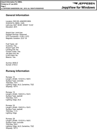
  • 1. General Information Location: RIO DE JANEIRO BRA ICAO/IATA: SBGL / GIG Lat/Long: S22° 48.60', W043° 15.03' Elevation: 28 ft Airport Use: Joint-Use Daylight Savings: Observed UTC Conversion: +3:00 = UTC Magnetic Variation: 23.0° W Fuel Types: Jet Customs: Yes Airport Type: IFR Landing Fee: No Control Tower: Yes Jet Start Unit: No LLWS Alert: No Beacon: Yes Sunrise: 0830 Z Sunset: 2142 Z Runway Information Runway: 10 Length x Width: 13123 ft x 148 ft Surface Type: concrete TDZ-Elev: 16 ft Lighting: Edge, ALS, Centerline, TDZ Stopway: 197 ft Runway: 15 Length x Width: 10433 ft x 154 ft Surface Type: asphalt TDZ-Elev: 16 ft Lighting: Edge, ALS Runway: 33 Length x Width: 10433 ft x 154 ft Surface Type: asphalt TDZ-Elev: 11 ft Lighting: Edge Runway: 28 Length x Width: 13123 ft x 148 ft Surface Type: concrete TDZ-Elev: 28 ft Lighting: Edge, ALS, Centerline, TDZ Stopway: 197 ft Communication Information ATIS: 127.600 Galeao Tower: 118.200 Galeao Tower: 118.000 Galeao Ground: 121.650 Galeao Clearance Delivery: 121.000 Macae Approach: 119.200 Macae Approach: 120.000 Sao Paulo Approach: 120.850 Sao Paulo Approach: 123.900 Sao Paulo Approach: 124.700 Sao Paulo Approach: 125.600 Sao Paulo Approach: 129.000 Macae Approach: 129.300 Sao Paulo Approach: 134.900 Rio Control: 120.550 TCA Galeao Operations: 122.500 Military Galeao Operations: 121.000 Rio Control: 134.950 TCA Rio Control: 134.400 TCA Rio Control: 133.300 TCA Rio Control: 132.975 TCA Secondary Rio Control: 129.800 TCA Rio Control: 129.200 TCA Rio Control: 128.900 TCA Rio Control: 126.200 TCA Rio Control: 125.950 TCA Rio Control: 124.950 TCA Rio Control: 121.250 TCA Rio Control: 120.750 TCA Rio Control: 119.725 TCA Rio Control: 119.350 TCA Rio Control: 119.000 TCA Curitiba ACC: 124.000 Curitiba ACC: 125.350 Curitiba ACC: 127.050 Curitiba ACC: 128.250 Curitiba ACC: 128.400 Curitiba ACC: 133.400 Curitiba ACC: 133.600 General Information Location: RIO DE JANEIRO BRA ICAO/IATA: SBGL / GIG Lat/Long: S22° 48.60', W043° 15.03' Elevation: 28 ft Airport Use: Joint-Use Daylight Savings: Observed UTC Conversion: +3:00 = UTC Magnetic Variation: 23.0° W Fuel Types: Jet Customs: Yes Airport Type: IFR Landing Fee: No Control Tower: Yes Jet Start Unit: No LLWS Alert: No Beacon: Yes Sunrise: 0830 Z Sunset: 2142 Z Runway Information Runway: 10 Length x Width: 13123 ft x 148 ft Surface Type: concrete TDZ-Elev: 16 ft Lighting: Edge, ALS, Centerline, TDZ Stopway: 197 ft Runway: 15 Length x Width: 10433 ft x 154 ft Surface Type: asphalt TDZ-Elev: 16 ft Lighting: Edge, ALS Runway: 33 Length x Width: 10433 ft x 154 ft Surface Type: asphalt TDZ-Elev: 11 ft Lighting: Edge Runway: 28 Length x Width: 13123 ft x 148 ft Surface Type: concrete TDZ-Elev: 28 ft Lighting: Edge, ALS, Centerline, TDZ Stopway: 197 ft Airport Information For SBGL Printed on 27 Jan 2018 Page 1 (c) JEPPESEN SANDERSON, INC., 2018, ALL RIGHTS RESERVED jep=JEPPESEN JeppView for Windows
  • 2. General Information Location: RIO DE JANEIRO BRA ICAO/IATA: SBGL / GIG Lat/Long: S22° 48.60', W043° 15.03' Elevation: 28 ft Airport Use: Joint-Use Daylight Savings: Observed UTC Conversion: +3:00 = UTC Magnetic Variation: 23.0° W Fuel Types: Jet Customs: Yes Airport Type: IFR Landing Fee: No Control Tower: Yes Jet Start Unit: No LLWS Alert: No Beacon: Yes Sunrise: 0830 Z Sunset: 2142 Z Runway Information Runway: 10 Length x Width: 13123 ft x 148 ft Surface Type: concrete TDZ-Elev: 16 ft Lighting: Edge, ALS, Centerline, TDZ Stopway: 197 ft Runway: 15 Length x Width: 10433 ft x 154 ft Surface Type: asphalt TDZ-Elev: 16 ft Lighting: Edge, ALS Runway: 33 Length x Width: 10433 ft x 154 ft Surface Type: asphalt TDZ-Elev: 11 ft Lighting: Edge Runway: 28 Length x Width: 13123 ft x 148 ft Surface Type: concrete TDZ-Elev: 28 ft Lighting: Edge, ALS, Centerline, TDZ Stopway: 197 ft Communication Information ATIS: 127.600 Galeao Tower: 118.200 Galeao Tower: 118.000 Galeao Ground: 121.650 Galeao Clearance Delivery: 121.000 Macae Approach: 119.200 Macae Approach: 120.000 Sao Paulo Approach: 120.850 Sao Paulo Approach: 123.900 Sao Paulo Approach: 124.700 Sao Paulo Approach: 125.600 Sao Paulo Approach: 129.000 Macae Approach: 129.300 Sao Paulo Approach: 134.900 Rio Control: 120.550 TCA Galeao Operations: 122.500 Military Galeao Operations: 121.000 Rio Control: 134.950 TCA Rio Control: 134.400 TCA Rio Control: 133.300 TCA Rio Control: 132.975 TCA Secondary Rio Control: 129.800 TCA Rio Control: 129.200 TCA Rio Control: 128.900 TCA Rio Control: 126.200 TCA Rio Control: 125.950 TCA Rio Control: 124.950 TCA Rio Control: 121.250 TCA Rio Control: 120.750 TCA Rio Control: 119.725 TCA Rio Control: 119.350 TCA Rio Control: 119.000 TCA Curitiba ACC: 124.000 Curitiba ACC: 125.350 Curitiba ACC: 127.050 Curitiba ACC: 128.250 Curitiba ACC: 128.400 Curitiba ACC: 133.400 Curitiba ACC: 133.600 Communication Information ATIS: 127.600 Galeao Tower: 118.200 Galeao Tower: 118.000 Galeao Ground: 121.650 Galeao Clearance Delivery: 121.000 Macae Approach: 119.200 Macae Approach: 120.000 Sao Paulo Approach: 120.850 Sao Paulo Approach: 123.900 Sao Paulo Approach: 124.700 Sao Paulo Approach: 125.600 Sao Paulo Approach: 129.000 Macae Approach: 129.300 Sao Paulo Approach: 134.900 Rio Control: 120.550 TCA Galeao Operations: 122.500 Military Galeao Operations: 121.000 Rio Control: 134.950 TCA Rio Control: 134.400 TCA Rio Control: 133.300 TCA Rio Control: 132.975 TCA Secondary Rio Control: 129.800 TCA Rio Control: 129.200 TCA Rio Control: 128.900 TCA Rio Control: 126.200 TCA Rio Control: 125.950 TCA Rio Control: 124.950 TCA Rio Control: 121.250 TCA Rio Control: 120.750 TCA Rio Control: 119.725 TCA Rio Control: 119.350 TCA Rio Control: 119.000 TCA Curitiba ACC: 124.000 Curitiba ACC: 125.350 Curitiba ACC: 127.050 Curitiba ACC: 128.250 Curitiba ACC: 128.400 Curitiba ACC: 133.400 Curitiba ACC: 133.600 Airport Information For SBGL Printed on 27 Jan 2018 Page 2 (c) JEPPESEN SANDERSON, INC., 2018, ALL RIGHTS RESERVED jep=JEPPESEN JeppView for Windows
  • 3. SANTACRUZ RASA AFONSOS CAXIAS ILHA SCRVOR CAXNDB IHNDB YLANDB AFSNDB D20 D40 D60 33 0^ 0^ ^ 090^ 210^ 1 50^ 210^ ^ 40 180^ 00^ 2 270^ D40 D60 D60 D40 JobimIntl SB(P)-307 SB(P)-308 SB(P)-320 SB(P)-331 SB(P)-302 SB(P) -319 D80D80 AptElevTranslevel:ByATC 28' AltSet:hPaTransalt:7000' JEPPESEN COMMSFAILURE 1.SetTranspondercode7600;and 2.Followcommunicationfailure procedureonrelevantSTAR and/orInstrumentApproach Chart. 3JAN14 119.0119.35120.55 129.2129.8 126.2128.9 133.3135.6121.5 PIRAI 115.0PAIPAID MARICA 114.8MIAMIAD PORTO 114.6PCXPCXD CAXIAS 112.3CXICXID (H) NOVA 215NOANOA PAIOL 415PPPP CXIR-278 CXI R-292 CXI CXI CXI R-298 PAIR-290 R-343 2600 4400 6600 5300 3900 2000 FL090 4000 3100 2400 2700 3500 4200 4700 3500 4400 5300 5000 7000 FL085FL095 FL095 FL085 6400 4900 2100 PCX R-360 MIAR-286MIAR-291 MIA R-308 MIAR-314 7000 2000 4400 17002000 3000 2500 4500 3100 9069' 22-00 22-30 23-00 23-30 24-00 42-0042-3043-0043-3044-0044-30 NOA298^ NOA098^ NOA103^ 21 NM R-278 10 020304050 10 1.Charttobeusedforcross-checkingofaltitudesassignedwhile underradarcontrol.2.DistancesarereferencedtoCXIVOR. PP028^ NOA 228^ PP 016^ PAIR-102 2600 *RIOControl(Approach)(R) 060 3 Galeao -AntonioC D20 INTERVALS CONTOUR 2000 8000 4000 6000 10-1R SBGL/GIG .RADAR.MINIMUM.ALTITUDES. Newchart.|JEPPESEN,2014.ALLRIGHTSRESERVED. GALEAO-ANTONIOCJOBIMINTL RIODEJANEIRO,BRAZIL CHANGES: Printed from JeppView for Windows 5.3.0.0 on 27 Jan 2018; Terminal chart data cycle 01-2018 (Expired); Notice: After 25 Jan 2018, 0000Z, this chart may no longer be valid
  • 4. COMMSLOSTLOST COMMS COMMSLOST COMMSLOST COMMSLOST COMMSLOST COMMSLOST COMMSLOST COMMSCOMMSLOST ALDEIA 112.1 ADAADAS22 48.8 W042 05.7 D MOLSU S21 50.4 W042 12.3 CHANGES: Apt Elev 28' 10-2 SBGL/GIG JEPPESEN .RNAV.STAR. 127.6 Alt Set: hPa Trans level: By ATC Trans alt: 7000' 2. RNAV 1: ATS surveillance system required. 1. RNAV 1 or RNP 1. operative: ADA, CXI, and PCX. 3. For aircraft not equipped with GNSS, the following DME must be GALEAO-ANTONIO CARLOS JOBIM INTL RIO DE JANEIRO, BRAZIL MSA ARP [DIVR1A] 090^ 270^ 160^ FL095 6300' 5000' 1 1 within 10 NM 1 5500' TRANSITIONS ADA MOLSU MAINTAIN 308^ course to DIVRO. MAINTAIN 232^ course to DIVRO. RWY 28 33 ROUTING procedure authorized by ATC or, on heading 150^, EXPECT vectors to final approach. Rwy 28: Complete arrival until KETUX and execute procedure authorized by ATC. Rwy 33: Complete arrival until OPSID and execute procedure authorized by ATC. 5000' until CXI 25 DME. Then, turn RIGHT to intercept final approach. Or, if under vectors on heading 150^, MAINTAIN heading, minimum altitude 34.9 9.9 ADA 232^ 308^ 277^ 234^ 277^ 097^ 47.3 4.49.7 9.0 MOLSU 150^hdg S22 43.3 KETUX W042 56.9 S22 51.9 OPSID W043 02.4 S22 39.6 DIVRO W042 42.1 At or above FL080 At or above 5000' CAXIAS 112.3 CXICXIS22 49.0 W043 15.6 D At or above 5000' At or below 7000' Direct distance to Galeao- Antonio Carlos Jobim Intl from: KETUX 18 NM OPSID 12 NM | JEPPESEN, 2013, 2016. ALL RIGHTS RESERVED. 2 DEC 16 At DIVRO, MAINTAIN 277^ course to KETUX. Then, complete procedure authorized by ATC. At DIVRO, MAINTAIN 277^ course to KETUX. Turn LEFT, course 234^ to OPSID. Then, complete .Eff.8.Dec. D-ATIS DIVRO 1A RNAV ARRIVAL Airport elevation. NOT TO SCALE Printed from JeppView for Windows 5.3.0.0 on 27 Jan 2018; Terminal chart data cycle 01-2018 (Expired); Notice: After 25 Jan 2018, 0000Z, this chart may no longer be valid
  • 5. COMMSLOST COMMSLOST COMMSLOST COMMSLOST COMMSLOST COMMSLOST COMMSLOST COMMSLOST COMMSLOST ALDEIA 112.1 ADAADAS22 48.8 W042 05.7 D MOLSU S21 50.4 W042 12.3 CHANGES: Apt Elev 28' SBGL/GIG JEPPESEN .RNAV.STAR. 127.6 Alt Set: hPa Trans level: By ATC Trans alt: 7000' 2. RNAV 1: ATS surveillance system required. 1. RNAV 1 or RNP 1. operating: ADA, CXI, and PCX. 3. For aircraft not equipped with GNSS, the following DME must be GALEAO-ANTONIO CARLOS JOBIM INTL RIO DE JANEIRO, BRAZIL MSA ARP [DIVR1B] 090^ 270^ 160^ FL095 6300' 5000' 1 1 within 10 NM 1 5500' TRANSITIONS ADA MOLSU MAINTAIN 308^ course to DIVRO. MAINTAIN 232^ course to DIVRO. ROUTING Complete arrival until VURUK and execute procedure authorized by ATC. 4000' until CXI 25 DME. Then, turn RIGHT to intercept final approach. Or, if under vectors on heading 150^, MAINTAIN heading, minimum altitude 34.9 ADA 232^ 308^ 277^ 277^ 097^ 47.3 4.49.7 9.0 MOLSU 150^hdg KETUX VURUK DIVRO CAXIAS 112.3 CXICXIS22 49.0 W043 15.6 D At or above 5000' At or below 7000' D-ATIS | JEPPESEN, 2016. ALL RIGHTS RESERVED. DIVRO 1B RNAV ARRIVAL 10-2A .Eff.8.Dec. (RWY 33) At DIVRO, MAINTAIN 277^ course to KETUX. Turn LEFT, course 274^ to VURUK. Then, complete procedure authorized by ATC or, on heading 150^, EXPECT vectors to final approach. At or above 4000' 274^ 7.2 At or above FL090 Direct distance from VURUK to: Galeao-Antonio Carlos Jobim Intl 10 NM 2 DEC 16 N22 45.6 W043 04.2 S22 43.3 W042 56.9 S22 39.6 W042 42.1 At or above FL080 Chart reindexed. NOT TO SCALE Printed from JeppView for Windows 5.3.0.0 on 27 Jan 2018; Terminal chart data cycle 01-2018 (Expired); Notice: After 25 Jan 2018, 0000Z, this chart may no longer be valid
  • 6. COMMSLOST COMMSLOST COMMSLOST COMMSLOST COMMSLOST COMMSLOST COMMSLOST ROPAS S23 54.0 W044 14.5 ILTIT S23 48.5 W044 02.2 ESORU S23 01.8 W044 40.6 EPGIP S22 52.3 W043 58.6 CHANGES: Apt Elev 30' SBGL/GIG JEPPESEN GALEAO-ANTONIO CARLOS JOBIM INTL 10-2B RIO DE JANEIRO, BRAZIL .RNAV.STAR. ATIS 127.6 Alt Set: hPa Trans level: By ATC Trans alt: 7000' [EPGI1A] 1. RNAV 1 or RNP 1. 2. RNAV 1: ATS surveillance system required. 3. For aircraft not equipped with GNSS, the following DME must be operative: CXI, MIA, and SCR. MSA ARP 090^ 270^ 160^ FL095 6300' 5000' 1 1 within 10 NM 1 5500' TRANSITIONS ESORU AKNUB KOLBI MAINTAIN 098^ course to EPGIP. ROUTING 025^ 098^ 098^ 086^ ESORU 12.5 14.5 5.0 8.822.05.7 39.9 14.8 5.3 3.8 330^hdg Direct distance from EGDUT to: Galeao-Antonio Carlos Jobim Intl 17 NM 098^ 278^ W044 01.3 KABUK S23 34.0 S22 47.4 GL~71 W043 37.6 S22 46.5 EGDUT W043 33.6 At or above FL090 At or above FL120 At or below FL210 At or above FL210 At or below FL230 278^ CAXIAS 112.3 CXICXIS22 49.0 W043 15.6 D At or above 6300'205^ (RWY 15) | JEPPESEN, 2013, 2016. ALL RIGHTS RESERVED. 086^ 049^ 086^ 050^ 266^ 230^ 28.5 40.0 KOLBI AKNUB W044 42.3 KOLBI S24 06.6 AKNUB S24 29.7 W044 34.4 MAINTAIN 086^ course to ILTIT. Turn LEFT course 025^ to EPGIP. Complete arrival until EGDUT and execute procedure authorized by ATC. Or, if under vectors on heading 330^, MAINTAIN heading, minimum altitude 6300' until CXI 29 DME. Then, turn RIGHT to intercept final approach. 1 JAN 16 EPGIP 1A RNAV Chart reindexed. .Eff.7.Jan. MAINTAIN 049^ course to ROPAS. Turn RIGHT, course 086^ to ILTIT. Turn LEFT, course 025^ to EPGIP. At EPGIP, MAINTAIN 098^ course to EGDUT. Then, complete procedure authorized by ATC or, on heading 330^, EXPECT vectors to final approach. NOT TO SCALE Printed from JeppView for Windows 5.3.0.0 on 27 Jan 2018; Terminal chart data cycle 01-2018 (Expired); Notice: After 25 Jan 2018, 0000Z, this chart may no longer be valid
  • 7. COMMSLOSTCOMMSLOSTCOMMSLOST COMMSLOST COMMSLOST COMMSLOST COMMSLOST COMMSLOSTCOMMSLOSTCOMMSLOST ESORU S23 01.8 W044 40.6 EPGIP S22 52.3 W043 58.6 ILTIT S23 48.5 W044 02.2 ROPAS S23 54.0 W044 14.5 CHANGES: Apt Elev 30' SBGL/GIG JEPPESEN .RNAV.STAR. ATIS 127.6 Alt Set: hPa Trans level: By ATC Trans alt: 7000' 2. RNAV 1: ATS surveillance system required. 1. RNAV 1 or RNP 1. operative: CXI, MIA, and SCR. 3. For aircraft not equipped with GNSS, the following DME must be GALEAO-ANTONIO CARLOS JOBIM INTL RIO DE JANEIRO, BRAZIL MSA ARP [EPGI1A] 090^ 270^ 160^ FL095 6300' 5000' 1 1 within 10 NM 1 5500' 10-2C TRANSITIONS ESORU AKNUB KOLBI MAINTAIN 098^ course to EPGIP. ROUTINGRWY 28 33 Rwy 28: Complete arrival until SEDBU and execute procedure authorized by ATC. Or, if under vectors on heading 100^, MAINTAIN heading, minimum altitude 5000' until CXI 26 DME. Then, turn RIGHT to intercept final approach. Rwy 33: Complete arrival until OPSID and execute procedure authorized by ATC. Or, if under vectors on heading 150^, MAINTAIN heading, minimum altitude 5000' until CXI 25 DME. Then, turn RIGHT to intercept final approach. 098^ 098^ 149^ 086^ 025^ 098^ 100^ 150^ 278^ 278^ 205^ hdg hdg 39.9 21.2 19.3 11.4 15.9 5.722.08.8 5.0 14.5 12.5 ESORU W044 01.3 KABUK S23 34.0 IVTAL S22 39.5 SEDBU W043 04.2 S22 51.9 OPSID W043 02.4 At or below FL230 At or above FL210 At or below FL210 Between FL130 & FL090 At or above 5000' At or above 5000' S22 42.4 W043 16.2 At or above FL080 CAXIAS 112.3 CXICXIS22 49.0 W043 15.6 D OPSID 12 NM SEDBU 13 NM Direct distance to Galeao- Antonio Carlos Jobim Intl from: | JEPPESEN, 2013, 2016. ALL RIGHTS RESERVED. MAINTAIN 086^ course to ILTIT. Turn LEFT course 025^ to EPGIP. S24 06.6 W044 42.3 KOLBI 086^ 266^ AKNUB S24 29.7 W044 34.4 050^ 230^ 049^ AKNUB40.0 28.5KOLBI086^ At or above FL120 1 JAN 16 .Eff.7.Jan. EPGIP 1A RNAV Chart reindexed. At EPGIP, MAINTAIN 098^ course to SEDBU. Then, complete procedure authorized by ATC or, on heading 100^, EXPECT vectors to final approach. At EPGIP, MAINTAIN 098^ course to IVTAL. Turn RIGHT, course 149^ to OPSID. Then, complete procedure authorized by ATC or, on heading 150^, EXPECT vectors to final approach. MAINTAIN 049^ course to ROPAS. Turn RIGHT course 086^ to ILTIT. Turn LEFT, course 025^ to EPGIP. NOT TO SCALE Printed from JeppView for Windows 5.3.0.0 on 27 Jan 2018; Terminal chart data cycle 01-2018 (Expired); Notice: After 25 Jan 2018, 0000Z, this chart may no longer be valid
  • 8. COMMS LOST COMMSLOSTCOMMSLOSTCOMMSLOSTCOMMSLOSTCOMMSLOSTCOMMSLOST COMMS D103 MCA 115.9 MCA D167 D127 D112 R278^ CAXIAS 112.3CXICXIS2249.0W04315.6 D CHANGES: Apt Elev 28' SBGL/GIG JEPPESEN .STAR. GALEAO-ANTONIO CARLOS JOBIM INTL RIO DE JANEIRO, BRAZIL 10-2D 127.6 090^ 270^ 160^ FL095 6300' 5000' 1 1 within10NM 15500' [EPGI1B] ROUTING byATCor,onheading330^,EXPECTvectorstofinalapproach. MAINTAINMCAR-278toEGDUT.Then,completeprocedureauthorized Alt Set: hPa Trans level: By ATC Trans alt: 7000' CompletearrivaluntilEGDUTandexecuteprocedureauthorized byATC.Or,ifundervectorsonheading330^,MAINTAINheading, minimumaltitude6300'untilCXI29DME.Then,turnRIGHTto interceptfinalapproach. 098^ 098^39.9 14.8 9.1 278^ 278^ Atorabove 6300' Atorabove FL090 EGDUT D16.8CXI ESORU EPGIP D79.5CXI D39.9CXI D25.4CXI330^hdg DirectdistancefromEGDUTto: Galeao-AntonioCarlos JobimIntl17NM MSACXIVOR (RWY 15) | JEPPESEN, 2013, 2016. ALL RIGHTS RESERVED. 2 DEC 16 .Eff.8.Dec. EPGIP 1B S2301.8 W04440.6 S2252.3 W04358.6 S2246.5 W04333.6 Chart reindexed, airport elevation. D-ATIS NOTTOSCALE Printed from JeppView for Windows 5.3.0.0 on 27 Jan 2018; Terminal chart data cycle 01-2018 (Expired); Notice: After 25 Jan 2018, 0000Z, this chart may no longer be valid
  • 9. D74.7 D10.3 R278^ R329^ MCA 115.9 MCA D86.1 D127 D167 COMMS LOSTCOMMS LOST COMMSLOSTCOMMSLOSTCOMMSLOSTCOMMSLOSTCOMMSLOSTCOMMSLOST COMMS COMMSLOST LOST 298^ CHANGES: Apt Elev 28' SBGL/GIG JEPPESEN .STAR. GALEAO-ANTONIO CARLOS JOBIM INTL RIO DE JANEIRO, BRAZIL 10-2E 127.6 090^ 270^ 160^ FL095 6300' 5000' 1 1 within10NM 15500' [EPGI1B] Alt Set: hPa Trans level: By ATC Trans alt: 7000' S2301.8 W04440.6 S2252.3 W04358.6 MARICA 114.8MIAMIAS2258.0W04253.5 D DirectdistancetoGaleao- AntonioCarlosJobimIntlfrom: RWY 28 33 ROUTING MAINTAINMCAR-278toSEDBU.Then,completeprocedureauthorizedbyATCor, onheading100^,EXPECTvectorstofinalapproach. MAINTAINMCAR-278toIVTAL.TurnRIGHT,MIAR-329toOPSID.Then,complete procedureauthorizedbyATCor,onheading150^,EXPECTvectorstofinalapproach. Rwy28: CompletearrivaluntilSEDBUandexecuteprocedureauthorizedby Rwy33: CompletearrivaluntilOPSIDandexecuteprocedureauthorizedby MSACXIVOR CAXIAS 112.3CXICXIS2249.0W04315.6 D 098^ 098^ 149^ 39.9 21.2 19.315.9 11.4 278^ 278^ 100^ 150^ hdg hdg Between FL130&FL090 Atorabove FL080 Atorabove 5000' ESORU EPGIP D79.5CXI D39.9CXI S2242.4 W04316.2 IVTAL S2239.5 W04304.2 SEDBU S2251.9 W04302.4 OPSID OPSID12NM SEDBU13NM D19.3CXI D105MCA ATC.Or,ifundervectorsonheading100^,MAINTAINheading, ATC.Or,ifundervectorsonheading150^,MAINTAINheading, minimumaltitude5000'untilCXI26DME.Then,turnRIGHTto interceptfinalapproach. minimumaltitude5000'untilCXI25DME.Then,turnRIGHTto interceptfinalapproach. | JEPPESEN, 2013, 2016. ALL RIGHTS RESERVED. 2 DEC 16 EPGIP 1B .Eff.8.Dec. Chart reindexed, airport elevation. Atorabove 5000' D-ATIS NOTTOSCALE Printed from JeppView for Windows 5.3.0.0 on 27 Jan 2018; Terminal chart data cycle 01-2018 (Expired); Notice: After 25 Jan 2018, 0000Z, this chart may no longer be valid
  • 10. COMMSLOST COMMSLOST COMMSLOST COMMSLOST LOST COMMS CHANGES: Apt Elev 28' SBGL/GIG JEPPESEN GALEAO-ANTONIO CARLOS JOBIM INTL 10-2F RIO DE JANEIRO, BRAZIL .RNAV.STAR. 127.6 Alt Set: hPa Trans level: By ATC Trans alt: 7000' (RWY 10) 1. RNAV 1 or RNP 1. 2. RNAV 1: ATS surveillance system required. 3. For aircraft not equipped with GNSS, the following DME must be operative: CXI, PAI, and SCR. MSA ARP 090^ 270^ 160^ FL095 6300' 5000' 1 1 within 10 NM 1 5500' Direct distance from DONGI to: Galeao-Antonio Carlos Jobim Intl 19 NM 086^ 098^ 025^ 097^ 14.5 5.0 8.820.9 5.0 6.011.7 39.9 131^ 097^ 11.9 205^ 278^ W044 40.6 ESORU S23 01.8 EPGIP S22 52.3 W043 58.6 W044 14.5 ROPAS S23 54.0 ILTIT S23 48.5 W044 02.2 W044 01.3 KABUK S23 34.0 W043 59.1 KUDSI S22 59.2 W043 35.2 DONGI S22 53.2 W043 46.6 VUSRA S22 56.0 At or above 6300'At or above FL080 At or above FL120 At or below FL210 At or above FL210 At or below FL230 ESORU 1A 086^ 266^ W044 42.3 KOLBI S24 06.6 086^ 28.5KOLBI 049^ 40.0 AKNUB 050^ 230^ AKNUB S24 29.7 W044 34.4 | JEPPESEN, 2013, 2016. ALL RIGHTS RESERVED. TRANSITIONS AKNUB KOLBI ROUTING MAINTAIN 086^ course to ILTIT. SID ESORU 1A ROPAS 1A 12.5 ROPAS 1A MAINTAIN 049^ course to ROPAS. Turn RIGHT, course 086^ to ILTIT. 2 DEC 16 .Eff.8.Dec. ESORU 1A [ESOR1A], ROPAS 1A [ROPA1A] RNAV MAINTAIN 098^ course to EPGIP. Turn RIGHT, course 131^ to VUSRA. Turn LEFT, course 097^ to DONGI. Then, complete procedure authorized by ATC. At ILTIT, turn LEFT, course 025^ to KUDSI. Turn RIGHT, course 097^ to DONGI. Then, complete procedure authorized by ATC. Complete arrival until DONGI and execute procedure authorized by ATC. Chart reindexed, airport elevation. D-ATIS NOT TO SCALE Printed from JeppView for Windows 5.3.0.0 on 27 Jan 2018; Terminal chart data cycle 01-2018 (Expired); Notice: After 25 Jan 2018, 0000Z, this chart may no longer be valid
  • 11. COMMSLOSTLOST COMMS COMMSLOST COMMSLOST COMMSLOST COMMSLOST COMMSLOST COMMSLOST COMMSCOMMSLOST CHANGES: Apt Elev 28' SBGL/GIG JEPPESEN .RNAV.STAR. 127.6 Alt Set: hPa Trans level: By ATC Trans alt: 7000' 2. RNAV 1: ATS surveillance system required. 1. RNAV 1 or RNP 1. operative: CXI, PAI, and PCX. 3. For aircraft not equipped with GNSS, the following DME must be GALEAO-ANTONIO CARLOS JOBIM INTL RIO DE JANEIRO, BRAZIL MSA ARP 090^ 270^ 160^ FL095 6300' 5000' 1 1 within 10 NM 1 5500' 10-2G STAR TODAB 1A GIGSO 1A RWY 10 15 LANDING At UTBOM, complete procedure authorized by ATC. Rwy 10: Rwy 15: Complete arrival until UTBOM and execute procedure authorized by ATC. Complete arrival until NOA and execute procedure authorized by ATC. Or, if under vectors on heading 275^, MAINTAIN heading, minimum altitude 6300' until CXI 25 DME. Then, turn LEFT to intercept final approach. 120^ 116^ 148^ 177^ 8.7 6.7 2.4 19.0 5.1 TODAB 1A 177^ 171^ 177^ MAVGU 8.2 18.0 30.9 10.6 5.5 GIGSO1A 357^ 357^ 098^ 052^ 6.0 7.1 5.0 224^ 278^ 232^MOLSU18.1 27.9 10.0 12.6 13.9 MAVGU S21 27.3 W044 09.0 OGMUK S21 34.4 W044 04.4 MEBGA S22 25.2 W044 06.9 115.0 PAI PIRAI PAIS22 27.2 W043 50.4 D 215 NOA NOVA NOAS22 43.1 W043 28.8 CAXIAS 112.3 CXICXIS22 49.0 W043 15.6 D UTBOM S22 38.5 W043 31.2 MOLSU S21 50.4 W042 12.3 S22 26.3 KOSRU W043 57.6 GIGSO S22 27.4 TODAB W043 47.9 S22 28.2 VAKUB W043 36.6 S22 22.3 SURNA W043 29.1 S21 50.7 IVREV W043 56.0 S22 18.6 UTNUG W043 41.6 DOKTO S22 06.3 W042 21.9 S22 33.6 W043 33.8 275^hdg At or above 6300' At or above 6300' At or above 7000' At or below FL120 At or above FL110 At or below FL120 Antonio Carlos Jobim Intl from: Direct distance to Galeao- NOA NDB 14 NM UTBOM 18 NM ROUTING MAVGU Transition: MOLSU Transition: | JEPPESEN, 2013, 2016. ALL RIGHTS RESERVED. .Eff.8.Dec. RNAV GIGSO 1A [GIGS1A] TODAB 1A [TODA1A] MAINTAIN 171^ course to OGMUK. Turn RIGHT, course 177^ to UTBOM. MAINTAIN 232^ course to DOKTO. Turn RIGHT, course 278^ to SURNA. Turn LEFT, course 224^ to GIGSO. Turn LEFT, course 177^ to UTBOM. MAINTAIN 120^ course to PAI. Turn LEFT, course 116^ to TODAB. Turn RIGHT, course 148^ to UTBOM. At UTBOM, MAINTAIN 177^ course to NOA. Then, complete procedure authorized by ATC or, on heading 275^, EXPECT vectors to final approach. 2 DEC 16 Chart reindexed, airport elevation. Between FL200 & FL190 Between FL190 & FL150 Between FL220 & FL190 D-ATIS NOT TO SCALE Printed from JeppView for Windows 5.3.0.0 on 27 Jan 2018; Terminal chart data cycle 01-2018 (Expired); Notice: After 25 Jan 2018, 0000Z, this chart may no longer be valid
  • 12. 066^ 116^ 135^ R328^ 104^ R351^ CXI 112.3 D95.3 D17.8 D15.4 D COMMSLOSTCOMMSLOST COMMSLOST COMMSLOST COMMSLOST COMMSLOST COMMSLOSTCOMMSLOST CHANGES: Apt Elev 28' SBGL/GIG JEPPESEN .STAR. RIO DE JANEIRO, BRAZIL 10-2H GALEAO-ANTONIO CARLOS JOBIM INTL 127.6 090^ 270^ 160^ FL095 6300' 5000' 1 1 within 10 NM 1 5500' MSA CXI VOR STAR GIGSO 1B TODAB 1B ROUTING MAINTAIN CXI R-351 to OGMUK. Turn RIGHT, NOA 177^ bearing to UTBOM. RWY 10 15 LANDING At UTBOM, complete procedure authorized by ATC. Rwy 10: Complete arrival until NOA and execute procedure authorized by ATC. Or, if Rwy 15: Complete arrival until UTBOM and execute procedure authorized by ATC. 171^ 177^ 177^ 116^ 120^ R300^ 148^ MAVGU OGMUK TODAB 1B 8.2 18.0 30.9 10.6 6.0 5.5 5.1 19.0 2.4 6.78.7 357^ 357^ 275^hdg FORA 1730 FRAFRAS21 46.1 W043 23.0 MAVGU S21 27.3 W044 09.0 S21 34.4 W044 04.4 MEBGA S22 25.2 W044 06.9 115.0 PAI PIRAI PAIS22 27.2 W043 50.4 D NOVA 215 NOANOAS22 43.1 W043 28.8 112.3 CXI CAXIAS CXIS22 49.0 W043 15.6 D UTBOM At or above 6300' OGMUK (CXI R-351/D87.1) S21 50.7 W043 56.0 IVREV D69.1 CXI D38.7 CXI S22 18.6 W043 41.6 UTNUG D28.5 CXI VAKUB S22 28.2 W043 36.6 D22.8 CXI GIGSO S22 33.6 W043 33.8 S22 38.5 W043 31.2 At or below FL120 At or above 7000' At or above 6300' At or above FL110 S22 26.3 KOSRU W043 57.6 S22 27.4 TODAB W043 47.9 (Fly-Over) (Fly-Over) Antonio Carlos Jobim Intl from: Direct distance to Galeao- NOA NDB 14 NM UTBOM 18 NM under vectors on heading 275^, MAINTAIN heading, minimum altitude 6300' until CXI 25 DME. Then, turn LEFT to intercept final approach. GIGSO 1B | JEPPESEN, 2013, 2016. ALL RIGHTS RESERVED. .Eff.8.Dec. GIGSO 1B [GIGS1B] TODAB 1B [TODA1B] Alt Set: hPa Trans level: By ATC Trans alt: 7000' MAINTAIN PAI R-300 to PAI. Turn LEFT, PAI R-116 to TODAB. Then, turn RIGHT, CXI R-328 to UTBOM. At UTBOM, MAINTAIN NOA 177^ bearing to NOA. Then, complete procedure authorized by ATC or, on heading 275^, EXPECT vectors to final approach. 2 DEC 16 Chart reindexed, airport elevation. D-ATIS NOT TO SCALE Printed from JeppView for Windows 5.3.0.0 on 27 Jan 2018; Terminal chart data cycle 01-2018 (Expired); Notice: After 25 Jan 2018, 0000Z, this chart may no longer be valid
  • 13. COMMSLOST COMMSLOST COMMSLOST COMMSLOST COMMSLOST COMMSLOST CHANGES: Apt Elev 28' SBGL/GIG JEPPESEN .RNAV.STAR. 127.6 Alt Set: hPa Trans level: By ATC Trans alt: 7000' 2. RNAV 1: ATS surveillance system required. 1. RNAV 1 or RNP 1. operating: CXI, PAI, and SCR. 3. For aircraft not equipped with GNSS, the following DME must be GALEAO-ANTONIO CARLOS JOBIM INTL RIO DE JANEIRO, BRAZIL MSA ARP [IVTA1A] 090^ 270^ 160^ FL095 6300' 5000' 1 1 within 10 NM 1 5500' TRANSITIONS MAVGU MEBGA OGMUK ROUTING Complete arrival until VURUK and execute procedure authorized by ATC. Or, if under vectors on heading 150^, MAINTAIN heading, minimum altitude 4000' until CXI 25 DME. Then, turn RIGHT to intercept final approach. 171^ 177^ 120^ 116^ 149^ 150^hdg 357^ 357^ 8.2 18.0 41.5 8.7 6.7 12.8 17.7 6.0 MEBGA MAVGU OGMUK 112.3 CXI CAXIAS CXIS22 49.0 W043 15.6 D 115.0 PAI PIRAI PAIS22 27.2 W043 50.4 D MAVGU S21 27.3 W044 09.0 S21 34.4 OGMUK W044 04.4 S22 25.2 MEBGA W044 06.9 At or above FL110 S22 26.3 KOSRU W043 57.6 S22 28.2 VAKUB W043 36.6 S21 50.7 IVREV W043 56.0 W043 16.2 S22 42.4 IVTAL S22 45.6 W043 04.2 VURUK At or above FL080 D-ATIS .Eff.8.Dec. IVTAL 1A RNAV ARRIVAL (RWY 33) At or above 4000'129^ 11.5 Direct distance from VURUK to: Galeao-Antonio Carlos Jobim Intl 10 NM | JEPPESEN, 2016. ALL RIGHTS RESERVED. MAINTAIN 177^ course to VAKUB. Turn LEFT, course149^ to IVTAL. At IVTAL, turn LEFT course 129^ to VURUK. Then, complete procedure authorized by ATC or, on heading 150^, EXPECT vectors to final approach. MAINTAIN 171^ course to OGMUK. Turn RIGHT, course 177^ to VAKUB. Turn LEFT, course 149^ to IVTAL. MAINTAIN 120^ course to PAI VOR. Turn LEFT, course 116^ to VAKUB. Turn RIGHT, course 149^ to IVTAL. 2 DEC 16 10-2J Chart reindexed. At or above FL100 NOT TO SCALE Printed from JeppView for Windows 5.3.0.0 on 27 Jan 2018; Terminal chart data cycle 01-2018 (Expired); Notice: After 25 Jan 2018, 0000Z, this chart may no longer be valid
  • 14. COMMSLOST COMMSLOST COMMSLOST COMMSLOST COMMSLOST COMMSLOST ESORU S23 01.8 W044 40.6 EPGIP S22 52.3 W043 58.6 ILTIT S23 48.5 W044 02.2 ROPAS S23 54.0 W044 14.5 CHANGES: Apt Elev 28' SBGL/GIG JEPPESEN .RNAV.STAR. 127.6 Alt Set: hPa Trans level: By ATC Trans alt: 7000' 2. RNAV 1: ATS surveillance system required. 1. RNAV 1 or RNP 1. operating: CXI, MIA, and SCR. 3. For aircraft not equipped with GNSS, the following DME must be GALEAO-ANTONIO CARLOS JOBIM INTL RIO DE JANEIRO, BRAZIL MSA ARP [IVTA1B] 090^ 270^ 160^ FL095 6300' 5000' 1 1 within 10 NM 1 5500' TRANSITIONS ESORU AKNUB KOLBI MAINTAIN 098^ course to IVTAL. ROUTING 098^ 098^ 086^ 025^ 098^ 150^ 278^ 278^ 205^ hdg 39.9 21.2 19.35.722.08.8 5.0 14.5 12.5 ESORU W044 01.3 KABUK S23 34.0 IVTAL S22 45.6 VURUK W043 04.2 At or below FL230 At or above FL210 At or below FL210 Between FL130 & FL090 S22 42.4 W043 16.2 At or above FL080 CAXIAS 112.3 CXICXIS22 49.0 W043 15.6 D S24 06.6 W044 42.3 KOLBI 086^ 266^ AKNUB S24 29.7 W044 34.4 050^ 230^ 049^ AKNUB40.0 28.5KOLBI086^ At or above FL120 MAINTAIN 049^ course to ROPAS. Turn RIGHT course 086^ to ILTIT. Turn LEFT, course 025^ to .Eff.2.Mar. D-ATIS Direct distance from VURUK to: Galeao-Antonio Carlos Jobim Intl 10 NM IVTAL 1B RNAV ARRIVAL (RWY 33) | JEPPESEN, 2016. ALL RIGHTS RESERVED. EPGIP. Turn RIGHT course 098^ to IVTAL. At IVTAL, turn RIGHT course 129^ to VURUK. Then, complete procedure authorized by ATC or, on heading 150^, EXPECT vectors to final approach. MAINTAIN 086^ course to ILTIT. Turn LEFT course 025^ to EPGIP. Turn RIGHT course 098^ to IVTAL. Complete arrival until VURUK and execute procedure authorized by ATC. Or, if under vectors on heading 150^, MAINTAIN heading, minimum altitude 4000' until CXI 25 DME. Then, turn RIGHT to intercept final approach. 129^11.5 At or above 4000' 10-2K IVTAL 1C deleted. 24 FEB 17 NOT TO SCALE Printed from JeppView for Windows 5.3.0.0 on 27 Jan 2018; Terminal chart data cycle 01-2018 (Expired); Notice: After 25 Jan 2018, 0000Z, this chart may no longer be valid
  • 15. COMMS LOSTLOST COMMSCOMMSLOSTCOMMSLOSTCOMMSLOSTCOMMSLOSTCOMMSLOSTCOMMSLOST COMMS COMMSLOST R094^ 329^ D18.2 D31.3 CHANGES: Apt Elev 28' SBGL/GIG JEPPESEN .STAR. RIO DE JANEIRO, BRAZIL 10-2M 127.6 GALEAO-ANTONIO CARLOS JOBIM INTL Alt Set: hPa Trans level: By ATC Trans alt: 7000' 090^ 270^ 160^ FL095 6300' 5000' 1 1 within10NM 15500' MSACXIVOR [UDOGA1] MAINTAINADAR-308toUDOGA. RWY 28 33 ROUTING LANDING AtUDOGA,turnLEFT,CXIR-094toKETUX.Then,completeprocedureauthorizedbyATC. AtUDOGA,turnLEFT,CXIR-094toKETUX.TurnLEFT,directtoOPSID.Then,complete procedureauthorizedbyATCor,onheading150^,EXPECTvectorstofinalapproach. Rwy28: CompletearrivaluntilKETUXandexecuteprocedureauthorizedbyATC. Rwy33: CompletearrivaluntilOPSIDandexecuteprocedureauthorizedbyATC. Or,ifundervectorsonheading150^,MAINTAINheading,minimumaltitude 5000'untilCXI25DME.Then,turnRIGHTtointerceptfinalapproach. 308^ 274^ 234^ 150^hdg 36.1 3.3 9.9 274^ 094^ DirectdistancefromOPSIDto: Galeao-AntonioCarlos JobimIntl12NM Atorabove 7000' Atorbelow 7000' Atorabove 5000' Atorabove 5000' CAXIAS 112.3CXICXIS2249.0W04315.6 D 114.6PCX PORTO PCXS2242.9W04251.4 D MARICA 114.8MIAMIAS2258.0W04253.5 D ALDEIA 112.1ADAADAS2248.8W04205.7 D (Fly-Over) OPSID D13.5PCX S2251.9 W04302.4 KETUX S2243.3 W04256.9 D28.0CXI UDOGA S2239.2 W04243.5 | JEPPESEN, 2013, 2016. ALL RIGHTS RESERVED. 2 DEC 16 UDOGA 1 .Eff.8.Dec. Chart reindexed, airport elevation. D-ATIS 9.8 NOTTOSCALE Printed from JeppView for Windows 5.3.0.0 on 27 Jan 2018; Terminal chart data cycle 01-2018 (Expired); Notice: After 25 Jan 2018, 0000Z, this chart may no longer be valid
  • 16. COMMSLOSTCOMMSLOSTLOST COMMS COMMSLOST COMMSLOST COMMSLOST LOST COMMSLOSTCOMMSLOST CHANGES: Apt Elev 28' SBGL/GIG JEPPESEN .RNAV.STAR. 127.6 Alt Set: hPa Trans level: By ATC Trans alt: 7000' 2. RNAV 1: ATS surveillance system required. 1. RNAV 1 or RNP 1. operative: CXI, PAI, and SCR. 3. For aircraft not equipped with GNSS, the following DME must be GALEAO-ANTONIO CARLOS JOBIM INTL RIO DE JANEIRO, BRAZIL MSA ARP [VAKU1A] 090^ 270^ 160^ FL095 6300' 5000' 1 1 within 10 NM 1 5500' 10-2N TRANSITIONS MAVGU MEBGA OGMUK MAINTAIN 171^ course to OGMUK. Turn RIGHT, course 177^ to VAKUB. MAINTAIN 120^ course to PAI. Turn LEFT, course 116^ to VAKUB. MAINTAIN 177^ course to VAKUB. RWY LANDING 28 33 procedure authorized by ATC or, on heading 100^, EXPECT vectors to final approach. Rwy 28: Complete arrival until SEDBU and execute procedure authorized by ATC. Or, if under vectors on heading 100^, MAINTAIN heading, minimum altitude 5000' until CXI 26 DME. Then, turn RIGHT to intercept final approach. Rwy 33: Complete arrival until OPSID and execute procedure authorized by ATC. Or, if under vectors on heading 150^, MAINTAIN heading, minimum altitude 5000' until CXI 25 DME. Then, turn RIGHT to intercept final approach. 171^ 177^ 120^ 116^ 149^ 098^ 100^ 150^ hdg hdg 357^ 357^ 8.2 18.0 41.5 8.7 6.7 12.8 17.7 6.0 11.4 15.9 MEBGA MAVGU OGMUK 112.3 CXI CAXIAS CXIS22 49.0 W043 15.6 D 115.0 PAI PIRAI PAIS22 27.2 W043 50.4 D MAVGU S21 27.3 W044 09.0 S21 34.4 OGMUK W044 04.4 S22 25.2 MEBGA W044 06.9 Direct distance from Galeao- Antonio Carlos Jobim Intl to: At or above FL110 S22 26.3 KOSRU W043 57.6 S22 28.2 VAKUB W043 36.6 S21 50.7 IVREV W043 56.0 W043 16.2 S22 42.4 IVTAL W043 04.2 S22 39.5 SEDBU S22 51.9 W043 02.4 OPSID At or above FL100 At or above FL080 At or above 5000' At or above 5000' OPSID 12 NM SEDBU 13 NM | JEPPESEN, 2013, 2016. ALL RIGHTS RESERVED. 2 DEC 16 .Eff.8.Dec. VAKUB 1A RNAV At VAKUB, MAINTAIN 149^ course to IVTAL. Turn LEFT, course 098^ to SEDBU. Then, complete At VAKUB, MAINTAIN 149^ course to OPSID. Then, complete procedure authorized by ATC or, on heading 150^, EXPECT vectors to final approach. Chart reindexed, airport elevation. D-ATIS NOT TO SCALE Printed from JeppView for Windows 5.3.0.0 on 27 Jan 2018; Terminal chart data cycle 01-2018 (Expired); Notice: After 25 Jan 2018, 0000Z, this chart may no longer be valid
  • 17. COMMSLOSTCOMMSLOSTLOST COMMS COMMSLOST COMMSLOST COMMSLOST LOST COMMSLOSTCOMMSLOST R329^ R278^MCA 115.9 MCAD74.4 177^ 260^ D D49.6 R351^ D95.3 CXI 112.3 D D15.4 171^ 177^ 120^ 116^ 149^ 098^ 100^ 150^ hdg hdg 357^ 357^ 8.2 18.0 41.5 8.7 6.7 12.8 17.7 6.0 11.4 MEBGA MAVGU OGMUK 112.3 CXI CAXIAS CXIS22 49.0 W043 15.6 D 115.0 PAI PIRAI PAIS22 27.2 W043 50.4 D MAVGU S21 27.3 W044 09.0 S21 34.4 W044 04.4 S22 25.2 MEBGA W044 06.9 Direct distance from Galeao- Antonio Carlos Jobim Intl to: At or above FL110 S22 26.3 KOSRU W043 57.6 S22 28.2 VAKUB W043 36.6 S21 50.7 IVREV W043 56.0 W043 16.2 S22 42.4 W043 04.2 S22 39.5 SEDBU S22 51.9 W043 02.4 At or above FL080 At or above 5000' CHANGES: Apt Elev 28' SBGL/GIG JEPPESEN .STAR. GALEAO-ANTONIO CARLOS JOBIM INTL 127.6 RIO DE JANEIRO, BRAZIL 10-2P 090^ 270^ 160^ FL095 6300' 5000' 1 1 within 10 NM 1 5500' [VAKU1B] TRANSITIONS MAVGU MEBGA OGMUK MAINTAIN CXI R-351 to OGMUK. Turn RIGHT, NOA 177^ bearing to VAKUB. MAINTAIN PAI R-300 to PAI. Turn LEFT, PAI R-116 to VAKUB. MAINTAIN NOA 177^ bearing to VAKUB. RWY LANDING 28 33 procedure authorized by ATC or, on heading 100^, EXPECT vectors to final approach. Rwy 28: Complete arrival until SEDBU and execute procedure authorized by ATC. Or, if under vectors on heading 100^, MAINTAIN heading, minimum altitude 5000' until CXI 26 DME. Then, turn RIGHT to intercept final approach. Rwy 33: Complete arrival until OPSID and execute procedure authorized by ATC. Or, if under vectors on heading 150^, MAINTAIN heading, minimum altitude 5000' until CXI 25 DME. Then, turn RIGHT to intercept final approach. (Fly-Over) MARICA 114.8 MIAMIAS22 58.0 W042 53.5 D NOVA 215 NOANOAS22 43.1 W043 28.8 15.9 At or above 5000' OPSID D10.3 MIA D31.9 MIA IVTAL D26.2 MIA At or above FL100 R300^ OGMUK (CXI R-351/D87.1) D69.2 CXI MSA CXI VOR SEDBU 13 NM OPSID 12 NM | JEPPESEN, 2013, 2016. ALL RIGHTS RESERVED. 2 DEC 16 VAKUB 1B .Eff.8.Dec. Alt Set: hPa Trans level: By ATC Trans alt: 7000' At VAKUB, MAINTAIN MIA R-329 to IVTAL. Turn LEFT MCA R-278 to SEDBU. Then, complete At VAKUB, MAINTAIN MIA R-329 to OPSID. Then, complete procedure authorized by ATC or, on heading 150^, EXPECT vectors to final approach. D-ATIS Chart reindexed, airport elevation. NOT TO SCALE Printed from JeppView for Windows 5.3.0.0 on 27 Jan 2018; Terminal chart data cycle 01-2018 (Expired); Notice: After 25 Jan 2018, 0000Z, this chart may no longer be valid
  • 18. LOST COMMSLOSTCOMMSLOSTCOMMSLOSTCOMMSLOSTCOMMSLOSTCOMMSLOST LOST 255^ 219^ 195^ 185^ 174^ R278^098^ R311^ 287^ SCR 113.6 YLA 330MCA 115.9 MCA D2.9 D127 CHANGES: Apt Elev 28' SBGL/GIG JEPPESEN .STAR. GALEAO-ANTONIO CARLOS JOBIM INTL RIO DE JANEIRO, BRAZIL 10-2Q 127.6 090^ 270^ 160^ FL095 6300' 5000' 1 1 within10NM 15500' [VUSR1B] (RWY 10) ROUTING Alt Set: hPa Trans level: By ATC Trans alt: 7000' DirectdistancefromDONGIto: Galeao-AntonioCarlos JobimIntl19NM MSACXIVOR MAINTAINMCAR-278toEPGIP.TurnRIGHT,SCRR-311toVUSRA.TurnLEFT, YLA098^bearingtoDONGI.Then,completeprocedureauthorizedbyATC. CompletearrivaluntilDONGIandexecuteprocedureauthorizedbyATC. 098^ 131^098^ 39.9 11.7 5.0 6.0 278^ Atorabove 6300' Atorabove FL080 ESORU S2301.8 W04440.6 S2252.3 W04358.6 SANTACRUZ 113.6SCRSCRS2257.0W04343.6 D 115.0PAI PIRAI PAIS2227.2W04350.4 D 112.3CXI CAXIAS CXIS2249.0W04315.6 D 330YLA ILHA YLAS2247.2W04310.1 S2256.0 VUSRA W04346.6 W04335.2 DONGI S2253.2 EPGIP D39.9CXI D79.5CXI D167MCA | JEPPESEN, 2013, 2016. ALL RIGHTS RESERVED. 2 DEC 16 VUSRA 1B .Eff.8.Dec. Chart reindexed, airport elevation. D-ATIS NOTTOSCALE Printed from JeppView for Windows 5.3.0.0 on 27 Jan 2018; Terminal chart data cycle 01-2018 (Expired); Notice: After 25 Jan 2018, 0000Z, this chart may no longer be valid
  • 19. CHANGES: Apt Elev 30' Trans level: By ATC Trans alt: 7000' SBGL/GIG JEPPESEN GALEAO-ANTONIO CARLOS JOBIM INTL RIO DE JANEIRO, BRAZIL .RNAV.SID. 1. RNAV 1 or RNP 1. 2. RNAV 1: ATS surveillance system required. [EVRA1A]MSAARP 090^ 270^ 160^ FL095 6300' 5000' 1 1 within10NM 15500' RWY 10 15 INITIALCLIMB Aftertake-off,MAINTAIN099^coursetoNUXIS. TurnLEFT,course002^toEVRAD. TRANSITIONS ENSODAtEVRAD,MAINTAIN002^coursetoENSOD. EPKAXAtEVRAD,MAINTAIN002^coursetoENSOD. Then,turnRIGHT,course047^toEPKAX. SIDURAtEVRAD,turnLEFT,course312^toUGROK. Then,turnLEFT,course278^toSIDUR. Rwy10:Ceilingnotrequired,Visibility600m(RVR200m). Rwy15:Ceilingnotrequired,Visibility600m(RVR550m). ThisSIDrequiresthefollowingminimumclimbgradients: 75100150200250300Gndspeed-KT 3.3%V/V(fpm) 6.0%V/V(fpm) 7.0%V/V(fpm) 2503505007008501000 450600900120015001800 5507001050140017502100 099^ 099^ 047^ 002^ 312^ 278^ 5.1 8.4 13.8 11.7 6.9 5.0 30.9 15.6 13.2 26.5 EPKAX ENSOD SIDUR Atorabove FL130Atorbelow FL190 SIDUR S2245.3 W04413.1 LIXEP S2237.8 W04340.7 S2232.0 UGROK W04316.0 S2245.6 VURUK W04304.2 NUXIS S2244.5 W04258.8 EVRAD S2236.6 W04301.9 ENSOD S2209.4 W04312.6 EPKAX S2145.1 W04301.0 DirectdistancefromGaleao- ThisSIDallowsforIFRminimumsbelowregulartake-offminimums: | JEPPESEN, 2013, 2017. ALL RIGHTS RESERVED. 148^Atorabove 500' Aftertake-off,MAINTAIN148^courseto500'. TurnLEFTdirecttoVURUK.TurnRIGHT,course 099^toNUXIS.TurnLEFT,course002^toEVRAD. 8.4 AntonioCarlosJobimIntl (Rwy15)to:VURUK10NM EVRAD 1A RNAV .Eff.30.Mar. 3. For aircraft not equipped with GNSS, the following DME must be operative: CXI, PCX, and SCR. 24 MAR 17 Atorabove FL210 Rwy10:7.0%to5000',then6.0%toEVRAD.Then3.3%. Rwy15:6.0%toEVRAD.Then,3.3%. 10-3 Procedure reindexed. NOTTOSCALE Printed from JeppView for Windows 5.3.0.0 on 27 Jan 2018; Terminal chart data cycle 01-2018 (Expired); Notice: After 25 Jan 2018, 0000Z, this chart may no longer be valid
  • 20. 278^ 251^ 161^ 145^ 132^ 121^ 227^ 132^ 002^ R279^ D27.6 D13.9 D7.0 BFR200 BFR NOA 215 D22.8 D51.6 D12.1 RWY 10 15 INITIALCLIMB TRANSITIONS ENSOD EPKAX SIDUR AtEVRAD,MAINTAINMIAR-002toENSOD. CHANGES: MSAPCXVOR Apt Elev 30' Trans level: By ATC Trans alt: 7000' SBGL/GIG JEPPESEN .SID. GALEAO-ANTONIO CARLOS JOBIM INTL RIO DE JANEIRO, BRAZIL 10-3B 090^ 270^FL095 5000' [EVRA1B] Rwy10:Ceilingnotrequired,Visibility600m(RVR200m). Rwy15:Ceilingnotrequired,Visibility600m(RVR550m). ThisSIDrequiresthefollowingminimumclimbgradients: Aftertake-off,turnRIGHT,PCXR-279toNUXIS.TurnLEFT,MIAR-002toEVRAD. AtEVRAD,MAINTAINMIAR-002toENSOD.TurnRIGHT,NOA047^bearingtoEPKAX. Aftertake-off,MAINTAINcourse148^to500'.TurnLEFT,PCXR-279toNUXIS.TurnLEFT, MIAR-002toEVRAD. AtEVRAD,turnLEFT,BFR312^bearingtoUGROK.TurnLEFT,TBE278^bearingtoSIDUR. 148^ 099^ 278^ 047^ 30.9 5.0 6.9 11.7 13.8 8.4 5.1 15.6 13.2 26.5 312^ PIRAI 115.0PAIPAIS2227.2W04350.4 D 215NOA NOVA NOAS2243.1W04328.8114.8MIA MARICA MIAS2258.0W04253.5 D 114.6PCX PORTO PCXS2242.9W04251.4 D S2245.3 W04413.1 S2237.8 LIXEP W04340.7 S2232.0 W04316.0 EVRAD S2236.6 W04301.9 VURUK S2245.6 W04304.2 ENSOD S2209.4 W04312.6 S2145.1 W04301.0 EPKAX ENSOD SIDURSIDUR UGROK EPKAX D25.2PCX D58.3PCX 1Atorbelow FL190 Atorabove FL130 D16.7PAI D22.0PAI D38.4MIA DirectdistancefromGaleao- AntonioCarlosJobimIntlto: VURUK10NM ThisSIDallowsforIFRminimumsbelowregulartake-offminimums: TAUBATE 430TBETBES2302.7W04531.0 | JEPPESEN, 2013, 2016. ALL RIGHTS RESERVED. .Eff.3.Mar. EVRAD 1B S2244.5 NUXIS W04258.8 1 26 FEB 16 Atorabove FL210 75100150200250300Gndspeed-KT 3.3%V/V(fpm) 6.0%V/V(fpm) 7.0%V/V(fpm) 2503505007008501000 450600900120015001800 5507001050140017502100 Rwy10:7.0%to5000',then6.0%toEVRAD.Then3.3%. Rwy15:6.0%toEVRAD.Then,3.3%. Crossing altitude, climb gradients. Atorabove 500' NOTTOSCALE Printed from JeppView for Windows 5.3.0.0 on 27 Jan 2018; Terminal chart data cycle 01-2018 (Expired); Notice: After 25 Jan 2018, 0000Z, this chart may no longer be valid
  • 21. CHANGES: Apt Elev 30' Trans level: By ATC Trans alt: 7000' SBGL/GIG JEPPESEN GALEAO-ANTONIO CARLOS JOBIM INTL RIO DE JANEIRO, BRAZIL .RNAV.SID. 1. RNAV 1 or RNP 1. 2. RNAV 1: ATS surveillance system required. MSAARP 090^ 270^ 160^ FL095 6300' 5500' 1 1 within10NM 15500' 10-3C [IH1A] RWY 10 15 INITIALCLIMB Aftertake-off,passing500',turnLEFT,directtoUTMIP.Turn Aftertake-off,MAINTAINcourse099^toUTMIP.TurnRIGHT, TRANSITIONS BITAK NAXOP UMBAD course278^toNAXOP. Rwy10:Ceilingnotrequired,Visibility600m(RVR200m). Rwy15:Ceilingnotrequired,Visibility600m(RVR550m). ThisSIDrequiresthefollowingminimumclimbgradients: Rwy10:3.3%(subjecttoATCclearance). Rwy15:5.5%to500'.Then3.3%(subjecttoATCclearance). BITAKTransition:6.0%to6000'(ATC). NAXOPTransition:6.0%toTIVRO(ATC). UMBADTransition:6.0%toFL220(ATC). 75100150200250300Gndspeed-KT 3.3%V/V(fpm) 5.5%V/V(fpm) 6.0%V/V(fpm) 2503505007008501000 450550850110014001700 450600900120015001800 UMBAD NAXOP BITAK 12.9 43.6 12.9 31.0 22.5 21.0 3.5 12.61.7 5.3 099^ 172^ 241^ 279^ 278^ 315IH RASA IHS2303.8W04308.8 S2245.1 UTMIP W04301.7 ISVUL S2251.2 W04257.8 TIVRO S2320.1 W04323.1 BITAK S2337.8 W04338.3 NAXOP S2330.9 W04409.4 S2316.9 UMBAD W04408.5 Atorabove 500' Atorabove FL090 Atorabove FL220 Atorabove FL240 DirectdistancefromGaleao- AntonioCarlosJobimIntlto: UTMIP13NM ThisSIDallowsforIFRminimumsbelowregulartake-offminimums: MAX230KT Atorabove 6000' MAX230KT MAX230KT | JEPPESEN, 2013, 2016. ALL RIGHTS RESERVED. IH 1A RNAV .Eff.3.Mar. 3. For aircraft not equipped with GNSS, the following DME must be operative: CXI, PCX, and SCR. course172^toISVUL.TurnRIGHT,course241^toIHNDB. RIGHT,course172^toISVUL.TurnRIGHT,course241^toIHNDB. AtIHNDB,MAINTAINcourse241^toBITAK. AtIHNDB,MAINTAINcourse241^toTIVRO.TurnRIGHT, AtIHNDB,turnRIGHT,course279^toUMBAD. 26 FEB 16 None. NOTTOSCALE Printed from JeppView for Windows 5.3.0.0 on 27 Jan 2018; Terminal chart data cycle 01-2018 (Expired); Notice: After 25 Jan 2018, 0000Z, this chart may no longer be valid
  • 22. CHANGES: Apt Elev 30' Trans level: By ATC Trans alt: 7000' 1. RNAV 1 or RNP 1. 2. RNAV 1: ATS surveillance system required. MSAARP 090^ 270^ 160^ FL095 6300' 5500' 1 1 within10NM 15500' [IH2A] INITIALCLIMB UMBAD NAXOP BITAK 12.9 44.8 12.9 31.3 22.5 21.0 279^ 278^ 315IH RASA IHS2303.8W04308.8 TIVRO S2320.1 W04323.1 BITAK S2337.8 W04338.3 NAXOP S2330.9 W04409.4 S2316.9 UMBAD W04408.5 Atorabove FL220 Atorabove FL240 JEPPESENSBGL/GIG GALEAO-ANTONIO CARLOS JOBIM INTL RIO DE JANEIRO, BRAZIL .Eff.7.Jan. 148^Atorabove 2500' TRANSITIONS BITAK NAXOP UMBAD Rwy15:Ceilingnotrequired,Visibility600m(RVR550m). ThisSIDrequiresthefollowingminimumclimbgradients: BITAKTransition:5.5%to2500'(ATC). NAXOPTransition:6.0%toFL240(ATC). UMBADTransition:6.0%toFL220(ATC). ThisSIDallowsforIFRminimumsbelowregulartake-offminimums: (RWY 15) Aftertake-off,passing2500',turnRIGHT,directtoIHNDB. 241^ DirectdistancefromGaleao- AntonioCarlosJobimIntlto: IHNDB16NM Rwy15:5.5%to2500',then3.3%(subjecttoATCclearance). .RNAV.SID. 75100150200250300Gndspeed-KT 3.3%V/V(fpm) 5.5%V/V(fpm) 6.0%V/V(fpm) 2503505007008501000 450550850110014001700 450600900120015001800 1 JAN 16 10-3D AtIHNDB,MAINTAINcourse241^toBITAK. course278^toNAXOP. AtIHNDB,MAINTAINcourse241^toTIVRO.TurnRIGHT, AtIHNDB,turnRIGHT,course279^toUMBAD. IH 2A RNAV 3. For aircraft not equipped with GNSS, the following DME must be operating: CXI, PCX, and SCR. | JEPPESEN, 2014, 2016. ALL RIGHTS RESERVED.Chart reindexed, airport elevation. NOTTOSCALE Printed from JeppView for Windows 5.3.0.0 on 27 Jan 2018; Terminal chart data cycle 01-2018 (Expired); Notice: After 25 Jan 2018, 0000Z, this chart may no longer be valid
  • 23. 241^ R279^ R352^ 278^ D9.7 D8.0 JEPPESEN CHANGES: MSAPCXVOR Apt Elev 30' Trans level: By ATC Trans alt: 7000' SBGL/GIG .SID. GALEAO-ANTONIO CARLOS JOBIM INTL RIO DE JANEIRO, BRAZIL 10-3E FL095 090^ 270^ 5000' DirectdistancefromGaleao- AntonioCarlosJobimIntlto: UTMIP13NM [IH1B] Rwy10:Ceilingnotrequired,Visibility600m(RVR200m). Rwy15:Ceilingnotrequired,Visibility600m(RVR550m). ThisSIDrequiresthefollowingminimumclimbgradients: Rwy10:3.3%(subjecttoATCclearance). Rwy15:5.5%to500',then3.3%(subjecttoATCclearance). 75100150200250300Gndspeed-KT 3.3%V/V(fpm) 5.5%V/V(fpm) 6.0%V/V(fpm) 2503505007008501000 450550850110014001700 450600900120015001800 Aftertake-off,turnRIGHT,PCXR-279toUTMIP. Aftertake-off,MAINTAINcourse148^to500'.TurnLEFT,PCXR-279toUTMIP. INITIALCLIMBRWY 10 15 Then,MAINTAINIH241^bearingtoTIVRO.TurnRIGHT,SAT278^bearingtoNAXOP. ROUTING 6.0%toTIVRO(ATC).148^ 099^ 172^ 278^ 241^ 5.3 1.7 12.6 3.5 21.0 31.0 12.9 1 SANTOS 375SATSATS2359.0W04615.8 S2330.9 W04409.4 315IH RASA IHS2303.8W04308.8 S2320.1 W04323.1 MARICA 114.8MIAMIAS2258.0W04253.5 D PORTO 114.6PCXPCXS2242.9W04251.4 D S2245.1 UTMIP W04301.7 ISVUL S2251.2 W04257.8 D64.6MIA D22.7PCX NAXOP TIVRO D77.2MIA D47.2PCX 230KT MAX Atorabove FL090 Atorabove FL240 (Fly-Over) ThisSIDallowsforIFRminimumsbelowregulartake-offminimums: (IH) MAX230KT 241^ Turns are not permitted prior to the DER. | JEPPESEN, 2013, 2016. ALL RIGHTS RESERVED. 1 JAN 16 Atorabove 6000' MAX230KT 1 D9.7MIA .Eff.7.Jan. AtUTMIP,turnRIGHT,MIAR-352toISVUL.TurnRIGHT,IH241^bearingtoIHNDB. Chart reindexed, airport elevation. IH 1B Atorabove 500' NOTTOSCALE Printed from JeppView for Windows 5.3.0.0 on 27 Jan 2018; Terminal chart data cycle 01-2018 (Expired); Notice: After 25 Jan 2018, 0000Z, this chart may no longer be valid
  • 24. 241^ 278^ D47.2 D69.7 JEPPESEN CHANGES: MSAPCXVOR Apt Elev 30' Trans level: By ATC Trans alt: 7000' SBGL/GIG .SID. GALEAO-ANTONIO CARLOS JOBIM INTL RIO DE JANEIRO, BRAZIL FL095 090^ 270^ 5000' DirectdistancefromGaleao- AntonioCarlosJobimIntlto: TIVRO32NM [IH2B] Rwy15:Ceilingnotrequired,Visibility600m(RVR550m). INITIALCLIMB 148^ 278^ 31.0 12.9 SANTOS 375SATSATS2359.0W04615.8 S2330.9 W04409.4 S2320.1 W04323.1 PORTO 114.6PCXPCXS2242.9W04251.4 D D64.6MIA NAXOP D77.2MIA Atorabove FL240 ThisSIDallowsforIFRminimumsbelowregulartake-offminimums: Turns are not permitted prior to the DER. (RWY 15) ThisSIDrequiresminimumclimbgradients: NAXOPTransition:6.0%toFL240(ATC). 114.8MIA MARICA MIAS2258.0W04253.5 D NAXOP BITAK 22.5 S2337.8 W04338.3 BITAK TIVRO Aftertake-off,MAINTAIN148^courseto2600'.TurnRIGHT,PCXR-241toTIVRO. TRANSITIONS BITAK NAXOP AtTIVRO,MAINTAINPCXR-241toBITAK. AtTIVRO,turnRIGHT,SAT278^bearingtoNAXOP. .Eff.7.Jan. Atorabove 2600' 5.5%to2600',then3.3%(subjecttoATCclearance). 75100150200250300Gndspeed-KT 3.3%V/V(fpm) 5.5%V/V(fpm) 6.0%V/V(fpm) 2503505007008501000 450550850110014001700 450600900120015001800 1 JAN 16 IH 2B 10-3F | JEPPESEN, 2014, 2016. ALL RIGHTS RESERVED.Chart reindexed, airport elevation. NOTTOSCALE Printed from JeppView for Windows 5.3.0.0 on 27 Jan 2018; Terminal chart data cycle 01-2018 (Expired); Notice: After 25 Jan 2018, 0000Z, this chart may no longer be valid
  • 25. CHANGES: Apt Elev 30' Trans level: By ATC Trans alt: 7000' SBGL/GIG JEPPESEN | JEPPESEN, 2016. ALL RIGHTS RESERVED. GALEAO-ANTONIO CARLOS JOBIM INTL RIO DE JANEIRO, BRAZIL New procedures at this airport. 090^ 270^ 160^ FL095 6300' 5000' 1 1 within 10 NM 1 5500' MSA ARP 10-3G1 JAN 16 .Eff.7.Jan. ISRIN 1A [ISRI1A], PUMSO 1A [PUMS1A] RNAV (RWY 15) 3. RNAV 1: ATS surveillance system required. 1. Certified GNSS required. 2. RNAV 1 or RNP 1. 4. For aircraft not equipped with GNSS, the following DME must be operative: ADA, MIA, and PCX. SID INITIAL CLIMB ISRIN 1A After take-off, turn LEFT, course 144^ to PP NDB. Turn LEFT, course 133^ to MIA VOR. Turn LEFT, course 052^ to PUMSO. Turn LEFT, course 014^ to ISRIN. At ISRIN, turn RIGHT, course 056^ to IMBAP. At ISRIN, turn RIGHT, course 071^ to UKENU. IMBAP UKENU TRANSITIONS SID INITIAL CLIMB PUMSO 1A After take-off, turn LEFT, course 144^ to PP NDB. Turn LEFT, course 133^ to MIA VOR. Turn At PUMSO, turn RIGHT, course 085^ to TISVA.TISVA TRANSITIONS LEFT, course 052^ to PUMSO. ADA At PUMSO, turn RIGHT, course 108^ to ADA VOR. Close-in obstacles not considered in climb gradient: OBSTACLES Trees 83', 1955m from threshold Rwy 33, azimuth 153^. These SIDs allow for IFR minimums below regular take-off minimums: Ceiling not required, Visibility 600m (RVR 550m). 144^ 133^ 052^ 056^ 071^ 085^ 014^ 4.7 16.3 6.7 5.3 36.5 41.0 27.7 10.0 37.4 85.1 IMBAP UKENU TISVA ADA ISRIN1A PUMSO1A PAIOL 415 PPPPS22 52.2 W043 09.9 114.8 MIA MARICA MIAS22 58.0 W042 53.5 D PUMSO MOMVO S22 46.9 W042 50.8 S22 48.8 W042 05.7 ALDEIA 112.1 ADAADAD TISVA S22 35.0 W042 15.0 MOTNO S22 19.4 W042 55.3 ISRIN S22 09.5 W042 57.0 W042 35.2 IMBAP S21 38.0 UKENU S21 12.1 W041 49.4 S22 52.2 W042 50.0 108^ At or above 7000' At or above FL080 At or above FL230 .RNAV.SID. NOT TO SCALE Printed from JeppView for Windows 5.3.0.0 on 27 Jan 2018; Terminal chart data cycle 01-2018 (Expired); Notice: After 25 Jan 2018, 0000Z, this chart may no longer be valid
  • 26. CHANGES: Apt Elev 30' Trans level: By ATC Trans alt: 7000' SBGL/GIG JEPPESEN GALEAO-ANTONIO CARLOS JOBIM INTL RIO DE JANEIRO, BRAZIL .RNAV.SID. 1. RNAV 1 or RNP 1. 2. RNAV 1: ATS surveillance system required. 10-3H Rwy28:Ceilingnotrequired,Visibility600m(RVR200m). Rwy33:Ceilingnotrequired,Visibility600m(RVR550m). 75100150200250300Gndspeed-KT 3.3%V/V(fpm) 5.0%V/V(fpm) 5.8%V/V(fpm) 2503505007008501000 400500750100012501500 450600900120014501800 090^ 270^ 160^ FL095 6300' 5000' 1 1 within10NM 15500' MSAARP Rwy28:5.0%to4000',then3.3%. Rwy33:5.8%to4000',then3.3%. LIXEP1ADeparture:7.4%toLIXEP(ATC). TheseSIDsallowforIFRminimumsbelowregulartake-offminimums: 7.4%V/V(fpm)6007501150150018502300 316^318^ 278^ 014^ 047^ 047^ 065^ 072^ 30.9 11.3 0.9 3.4 8.6 8.7 35.4 42.5 61.8 111 LIXEP1A NIBGU1AEDNAM EPKAX IMBAP UKENU Atorabove FL110 S2243.1W04328.8 NOVA 215NOANOA SIDUR S2245.3 W04413.1 LIXEP S2237.8 W04340.7 EDNAM S2149.0 W04325.4 EPKAX S2145.1 W04301.0 IMBAP S2138.0 W04235.2 W04149.4 UKENU S2112.1 W04319.7 NIBGU S2224.1 Atorbelow FL090 DirectdistancefromGaleao- AntonioCarlosJobimIntlto: NOANDB14NM Atorbelow 7000' Atorbelow 7000' MAX 270KT TheseSIDsrequirethefollowingminimumclimbgradients: | JEPPESEN, 2013, 2016. ALL RIGHTS RESERVED. RWY 28 33 INITIALCLIMB LIXEP1A NIBGU1A ROUTINGSID TurnLEFT,course278^toSIDUR. EDNAMAtNIBGU,turnLEFT,course014^toEDNAM. EPKAXAtNIBGU,MAINTAINcourse047^toEPKAX. IMBAPAtNIBGU,turnRIGHT,course065^toIMBAP. UKENUAtNIBGU,turnRIGHT,course072^toUKENU. TRANSITIONS 1 JAN 16 Chart reindexed, airport elevation. RNAV LIXEP 1A [LIXE1A], NIBGU 1A [NIBG1A] Aftertake-off,turnRIGHT,course316^toNOANDB. Aftertake-off,turnLEFT,course316^toNOANDB. AtNOANDB,turnRIGHT,course318^toLIXEP. AtNOANDB,turnRIGHT,course047^toNIBGU. .Eff.7.Jan. 3. For aircraft not equipped with GNSS, the following DME must be operative: MCA, PAI, and PCX. NOTTOSCALE Printed from JeppView for Windows 5.3.0.0 on 27 Jan 2018; Terminal chart data cycle 01-2018 (Expired); Notice: After 25 Jan 2018, 0000Z, this chart may no longer be valid
  • 27. 014^ 014^ 359^ 332^ 315^ 278^ D60.5 CHANGES: Apt Elev 30' Trans level: By ATC Trans alt: 7000' SBGL/GIG JEPPESEN GALEAO-ANTONIO CARLOS JOBIM INTL RIO DE JANEIRO, BRAZIL 10-3J Rwy28:Ceilingnotrequired,Visibility600m(RVR200m). Rwy33:Ceilingnotrequired,Visibility600m(RVR550m). 75100150200250300Gndspeed-KT 3.3%V/V(fpm) 5.0%V/V(fpm) 5.8%V/V(fpm) 2503505007008501000 400500750100012501500 450600900120014501800 090^ 270^ 160^ FL095 6300' 5000' 1 1 within10NM 15500' Rwy28:5.0%to4000',then3.3%. Rwy33:5.8%to4000',then3.3%. LIXEP1BDeparture:7.4%toLIXEP(ATC). TheseSIDsallowforIFRminimumsbelowregulartake-offminimums: 7.4%V/V(fpm)6007501150150018502300 DirectdistancefromGaleao- AntonioCarlosJobimIntlto: NOANDB14NM MSACXIVOR .SID. 316^ 318^ 278^ 047^ 30.9 11.30.9 3.4 8.6 8.7 42.5 35.4 EDNAM EPKAX LIXEP1B NIBGU1B 430TBE TAUBATE TBES2302.7W04531.0W04413.1 SIDUR S2245.3 S2237.8 W04340.7 SANTACRUZ 113.6SCRSCRS2257.0W04343.6 D NOVA 215NOANOAS2243.1W04328.8 CAXIAS 112.3CXICXIS2249.0W04315.6 D PORTO 114.6PCXPCXS2242.9W04251.4 D EDNAM S2149.0 W04325.4 EPKAX S2145.1 W04301.0 S2224.1 W04319.7 NIBGU LIXEP D25.7CXI D14.2CXI Atorbelow 7000' Atorbelow 7000' (Fly-Over) Atorbelow FL090 Atorabove FL110 TheseSIDsrequirethefollowingminimumclimbgradients: | JEPPESEN, 2013, 2016. ALL RIGHTS RESERVED. RWYINITIALCLIMB 28 33 ROUTINGSID LIXEP1B NIBGU1B TurnLEFT,TBE278^bearingtoSIDUR. EDNAM EPKAX TRANSITIONS AtNIBGU,turnLEFT,CXIR-014toEDNAM. AtNIBGU,MAINTAINNOA047^bearingtoEPKAX. 1 JAN 16 .Eff.7.Jan. LIXEP 1B [LIXE1B] NIBGU 1B [NIBG1B] Chart reindexed, airport elevation. Aftertake-off,turnRIGHT,NOA316^bearingtoNOANDB. Aftertake-off,turnLEFT,NOA316^bearingtoNOANDB. AtNOANDB,turnRIGHT,NOA318^bearingtoLIXEP. AtNOANDB,turnRIGHT,NOA047^bearingtoNIBGU. NOTTOSCALE Printed from JeppView for Windows 5.3.0.0 on 27 Jan 2018; Terminal chart data cycle 01-2018 (Expired); Notice: After 25 Jan 2018, 0000Z, this chart may no longer be valid
  • 28. CHANGES: Apt Elev 28' Trans level: By ATC Trans alt: 7000' SBGL/GIG JEPPESEN GALEAO-ANTONIO CARLOS JOBIM INTL 10-3K .RNAV.SID. 1. RNAV 1 or RNP 1. 2. RNAV 1: ATS surveillance system required. MSA ARP 090^ 270^ 160^ FL095 6300' 5000' 1 1 within 10 NM 1 5500' RIO DE JANEIRO, BRAZIL [PCX1A] RWY INITIAL CLIMB 10 15 TRANSITIONS ADA IMBAP ISRIN TISVA UKENU 4. Rwy 15: Turns are not permitted prior to the DER. This SID allows for IFR minimums below regular take-off minimums: Rwy 10: Ceiling not required, Visibility 600m (RVR 200m). Rwy 15: Ceiling not required, Visibility 600m (RVR 550m). Rwy 10: IMBAP, ISRIN, and UKENU Transitions: 3.3% (subject to ATC clearance). ADA and TISVA Transitions: 3.3%. Rwy 15: ADA and TISVA Transitions: 5.5% to 500', then 3.3%. IMBAP, ISRIN, and UKENU Transitions: 5.5% to 500'. Then, 3.3% (subject to ATC clearance). 75 100 150 200 250 300Gnd speed-KT 3.3% V/V (fpm) 5.5% V/V (fpm) 250 350 500 700 850 1000 450 550 850 1100 1400 1700 099^ 148^ 099^ 120^ 070^ 055^014^ 37.4 85.1 10.0 23.7 34.6 42.7 IMBAP UKENU ISRIN TISVA ADA UKENU S21 12.1 W041 49.4 W042 35.2 IMBAP S21 38.0 ISRIN S22 09.5 W042 57.0 PORTO 114.6 PCXPCXS22 42.9 W042 51.4 D UTMIP S22 45.1 W043 01.7 TISVA S22 35.0 W042 15.0 112.1 ADA ALDEIA ADAS22 48.8 W042 05.7 D Direct distance from Galeao- Antonio Carlos Jobim Intl to: UTMIP 13 NM 099^ 9.7 | JEPPESEN, 2013, 2016. ALL RIGHTS RESERVED. 2 DEC 16 PCX 1A RNAV .Eff.8.Dec. 3. For aircraft not equipped with GNSS, the following DME must be operative: ADA, MCA, MIA, and PCX. After take-off, turn RIGHT, course 099^ to PCX VOR. After take-off, MAINTAIN course 148^ to 500'. Turn LEFT, direct to UTMIP. Turn RIGHT, course 099^ to PCX VOR. At PCX VOR, turn RIGHT, course 120^ to ADA VOR. At PCX VOR, turn LEFT, course 014^ to ISRIN. Then, turn RIGHT, course 055^ to IMBAP. At PCX VOR, turn LEFT, course 014^ to ISRIN. At PCX VOR, MAINTAIN course 099^ to TISVA. At PCX VOR, turn LEFT, course 014^ to ISRIN. Then, turn RIGHT, course 070^ to UKENU. S22 19.4 MOTNO W042 55.3 FL230 At or above This SID requires minimum climb gradients: Chart reindexed, airport elevation. At or above 500' NOT TO SCALE Printed from JeppView for Windows 5.3.0.0 on 27 Jan 2018; Terminal chart data cycle 01-2018 (Expired); Notice: After 25 Jan 2018, 0000Z, this chart may no longer be valid
  • 29. CHANGES: Apt Elev 30' Trans level: By ATC Trans alt: 7000' SBGL/GIG JEPPESEN GALEAO-ANTONIO CARLOS JOBIM INTL 10-3M .RNAV.SID. 1. RNAV 1 or RNP 1. 2. RNAV 1: ATS surveillance system required. MSA ARP 090^ 270^ 160^ FL095 6300' 5000' 1 1 within 10 NM 1 5500' RIO DE JANEIRO, BRAZIL [PCX2A] RWY INITIAL CLIMB 10 15 TRANSITIONS IMBAP ISRIN UKENU 4. Rwy 15: Turns are not permitted prior to the DER. This SID allows for IFR minimums below regular take-off minimums: Rwy 10: Ceiling not required, Visibility 600m (RVR 200m). Rwy 15: Ceiling not required, Visibility 600m (RVR 550m). 75 100 150 200 250 300Gnd speed-KT 3.3% V/V (fpm) 250 350 500 700 850 1000 099^ 148^ 070^ 055^014^ 37.4 85.1 33.7 IMBAP UKENU ISRIN UKENU S21 12.1 W041 49.4 W042 35.2 IMBAP S21 38.0 ISRIN S22 09.5 W042 57.0 PORTO 114.6 PCXPCXS22 42.9 W042 51.4 D UTMIP S22 45.1 W043 01.7 Direct distance from Galeao- Antonio Carlos Jobim Intl to: UTMIP 13 NM 099^ 9.7 This SID requires a minimum climb gradient of 3.3%. | JEPPESEN, 2014, 2016. ALL RIGHTS RESERVED. 1 JAN 16 .Eff.7.Jan. PCX 2A RNAV 3. For aircraft not equipped with GNSS, the following DME must be operative: MCA, MIA, and PCX. After take-off, turn RIGHT, course 099^ to PCX VOR. After take-off, MAINTAIN course 148^ to 500'. Turn LEFT, direct to UTMIP. Turn RIGHT, course 099^ to PCX VOR. At PCX VOR, turn LEFT, course 014^ to ISRIN. Then, turn RIGHT, course 055^ to IMBAP. At PCX VOR, turn LEFT, course 014^ to ISRIN. At PCX VOR, turn LEFT, course 014^ to ISRIN. Then, turn RIGHT, course 070^ to UKENU. Chart reindexed, airport elevation. At or above 4200' At or above 500' FL100 & FL180 Between NOT TO SCALE Printed from JeppView for Windows 5.3.0.0 on 27 Jan 2018; Terminal chart data cycle 01-2018 (Expired); Notice: After 25 Jan 2018, 0000Z, this chart may no longer be valid
  • 30. D33.7 D D CHANGES: MSA PCX VOR Apt Elev 30' Trans level: By ATC Trans alt: 7000' SBGL/GIG JEPPESEN .SID. GALEAO-ANTONIO CARLOS JOBIM INTL RIO DE JANEIRO, BRAZIL 10-3N Rwy 15: Turns are not permitted prior to the DER. [PCX1B] 090^ 270^FL095 5000' RWY 10 15 ADA ISRIN INITIAL CLIMB TRANSITIONS This SID allows for IFR minimums below regular take-off minimums: Rwy 10: Ceiling not required, Visibility 600m (RVR 200m). Rwy 15: Ceiling not required, Visibility 600m (RVR 550m). This SID requires the following minimum climb gradients: Rwy 15: 5.5% to 500'. Then, 3.3% (subject to ATC clearance). Gnd speed-KT 3.3% V/V (fpm) 5.5% V/V (fpm) 75 100 150 200 250 300 250 350 500 700 850 1000 450 550 850 1100 1400 1700 099^ 148^ 120^ 014^ R279^ 10.0 23.7 9.7 42.7 ISRIN ADA At or above 500' UTMIP S22 45.1 W043 01.7 S22 09.5 ISRIN W042 57.0 114.6 PCX PORTO PCXS22 42.9 W042 51.4 D 112.1 ADA ALDEIA ADAS22 48.8 W042 05.7 D (Fly-Over) (Fly-Over) Direct distance from Galeao- Antonio Carlos Jobim Intl to: UTMIP 13 NM | JEPPESEN, 2013, 2016. ALL RIGHTS RESERVED. 1 JAN 16 At or above FL230 MOTNO S22 19.4 W042 55.3 .Eff.7.Jan. Chart reindexed, airport elevation. PCX 1B After take-off, turn RIGHT, PCX R-279 to PCX VOR. After take-off, MAINTAIN course 148^ to 500'. Turn LEFT, PCX R-279 to PCX VOR. At PCX VOR, turn RIGHT, PCX R-120 to ADA VOR. At PCX VOR, turn LEFT, PCX R-014 to ISRIN. NOT TO SCALE Printed from JeppView for Windows 5.3.0.0 on 27 Jan 2018; Terminal chart data cycle 01-2018 (Expired); Notice: After 25 Jan 2018, 0000Z, this chart may no longer be valid
  • 31. CHANGES: Apt Elev 30' Trans level: By ATC Trans alt: 7000' SBGL/GIG JEPPESEN GALEAO-ANTONIO CARLOS JOBIM INTL RIO DE JANEIRO, BRAZIL .RNAV.SID. 1. RNAV 1 or RNP 1. 2. RNAV 1: ATS surveillance system required. MSAARP 090^ 270^ 160^ FL095 6300' 5000' 1 1 within10NM 15500' 10-3P RWYINITIALCLIMB 28 33 ROUTINGSID PUMSO1A SURKU1A TRANSITIONS ADA BITAK NAXOP TISVA UMBAD AtSURKU,MAINTAINcourse220^toBITAK. AtSURKU,MAINTAINcourse220^toKUGOV.TurnRIGHT,course278^toNAXOP. AtPUMSO,turnLEFT,course085^toTISVA. AtSURKU,turnRIGHT,course279^toUMBAD. Rwy28:5.0%to4000'.Then3.3%. Rwy33:5.8%to4000'.Then3.3%. BITAKandNAXOPTransitions:5.9%toKUGOV(ATC). UMBADTransition:5.9%toFL220(ATC). GradientssubjecttoATCclearance: BITAK,NAXOP,andUMBADTransitions: Rwy28:5.0%to4000'.Then3.3%. Rwy33:5.8%to4000'.Then3.3%. 75100150200250300Gndspeed-KT 3.3%V/V(fpm) 5.0%V/V(fpm) 5.8%V/V(fpm) 5.9%V/V(fpm) 2503505007008501000 400500750100012501500 450600900120014501800 450600900120015001800 TheseSIDsallowforIFRminimums belowregulartake-offminimums: Rwy28:Ceilingnotrequired, Visibility600m(RVR200m). Rwy33:Ceilingnotrequired, Visibility600m(RVR550m). TheseSIDsrequirethefollowingminimumclimb gradients: 329^ 126^108^ 085^ 220^ 279^ 278^ 8.321.6 36.5 41.0 12.8 25.7 12.9 12.9 21.8 15.1 16.2 4.0 AFONSOS 270AFSAFSS2252.0W04322.0 Atorabove 6000' MAX250KT PUMSO1A SURKU1A UMBAD NAXOP TISVA ADA Atorabove FL240 Atorbelow 7000' BITAK S2337.8 W04338.3 NAXOP S2330.9 W04409.4 UMBAD S2316.9 W04408.5 UTNOP S2253.9 W04313.3 PUMSO S2252.2 W04250.0 TISVA S2235.0 W04215.0ALDEIA 112.1ADAADAS2248.8W04205.7 D SURKU S2308.0 W04327.7 S2243.9 EDMAD W04323.1 MAX250KT DirectdistancefromGaleao- AntonioCarlosJobimIntlto: EDMAD9NM KUGOV S2322.4 W04332.8 Atorabove FL220 BITAK Atorbelow 7000' | JEPPESEN, 2013, 2016. ALL RIGHTS RESERVED. 1 JAN 16 .Eff.7.Jan. Chart reindexed, airport elevation. PUMSO 1A [PUMS1A], SURKU 1A [SURK1A] RNAV Aftertake-off,turnRIGHT,course329^toEDMAD.TurnLEFT,directtoAFSNDB. Aftertake-off,course329^toEDMAD.TurnLEFT,directtoAFSNDB. AtAFSNDB,turnLEFT,course126^toUTNOP.TurnLEFT,course108^toPUMSO. AtAFSNDB,turnRIGHT,course220^toSURKU. AtPUMSO,MAINTAINcourse108^toADAVOR. 3. For aircraft not equipped with GNSS, the following DME must be operative: CXI, MCA, PAI, and PCX. NOTTOSCALE Printed from JeppView for Windows 5.3.0.0 on 27 Jan 2018; Terminal chart data cycle 01-2018 (Expired); Notice: After 25 Jan 2018, 0000Z, this chart may no longer be valid
  • 32. D62.6 D 099^ 072^ 222^ 237^ 278^ D8.6 143^ CHANGES: Apt Elev 30' Trans level: By ATC Trans alt: 7000' SBGL/GIG JEPPESEN .SID. GALEAO-ANTONIO CARLOS JOBIM INTL RIO DE JANEIRO, BRAZIL 10-3Q 090^ 270^ 160^ FL095 6300' 5000' 1 1 within10NM 15500' MSACXIVOR RWYINITIALCLIMB 28 33 ROUTINGSID PUMSO1B SURKU1B TheseSIDsrequirethefollowingminimumclimbgradients: Rwy28:5.0%to4000'.Then,3.3%. Rwy33:5.8%to4000'.Then,3.3%. TheseSIDsallowforIFRminimums belowregulartake-offminimums: Rwy28:Ceilingnotrequired, Visibility600m(RVR200m). Rwy33:Ceilingnotrequired, Visibility600m(RVR550m). 75100150200250300Gndspeed-KT 3.3%V/V(fpm) 5.0%V/V(fpm) 2503505007008501000 400500750100012501500 5.8%V/V(fpm)450600900120014501800 SANTOS 375SATSATS2359.0W04615.8 329^ 278^ 126^108^ R288^ 8.3 15.1 21.8 12.9 21.6 41.0 PUMSO1B SURKU1B (CXI) ALDEIA 112.1ADAADAS2248.8W04205.7 D S2330.9 NAXOP W04409.4 315IH RASA IHS2303.8W04308.8 SANTACRUZ 113.6SCRSCRS2257.0W04343.6 D AFONSOS 270AFSAFSS2252.0W04322.0 112.3CXI CAXIAS CXIS2249.0W04315.6 D UTNOP PUMSO S2252.2 W04250.0 SURKU S2308.0 W04327.7 S2243.9 EDMAD W04323.1 S2322.4 KUGOV W04332.8 Atorabove FL240 (Fly-Over) (Fly-Over) Atorabove 6000' MAX250KT S2253.9W04313.3 Atorbelow 7000' 220^ Atorbelow 7000' | JEPPESEN, 2013, 2016. ALL RIGHTS RESERVED. 4.0 12.8 1 JAN 16 PUMSO 1B [PUMS1B] SURKU 1B [SURK1B] .Eff.7.Jan. Chart reindexed, airport elevation. Aftertake-off,turnRIGHT,CXIR-329toEDMAD.Then,turnLEFT,directtoAFSNDB. Aftertake-off,MAINTAINCXIR-329toEDMAD.Then,turnLEFT,directtoAFSNDB. AtAFSNDB,turnLEFT,AFS126^bearingtoUTNOP.TurnLEFT,ADAR-288toADAVOR. AtAFSNDB,turnRIGHT,AFS220^bearingtoKUGOV.TurnRIGHT,SAT278^bearingtoNAXOP. MAX250KT NOTTOSCALE Printed from JeppView for Windows 5.3.0.0 on 27 Jan 2018; Terminal chart data cycle 01-2018 (Expired); Notice: After 25 Jan 2018, 0000Z, this chart may no longer be valid
  • 33. SBGL/GIG CHANGES: Apt Elev 30' Trans level: By ATC Trans alt: 7000' JEPPESEN GALEAO-ANTONIO CARLOS JOBIM INTL RIO DE JANEIRO, BRAZIL 10-3S [UGRO1A] INITIALCLIMBRWY 10 15 ThisSIDallowsforIFRminimumsbelowregulartake-offminimums: Rwy10:Ceilingnotrequired,Visibility600m(RVR200m). Rwy15:Ceilingnotrequired,Visibility600m(RVR550m). ThisSIDrequiresthefollowingminimumclimbgradients: GradientssubjecttoATCclearance: Rwy10:4.7%to6000'.Then,3.3%. Rwy15:4.1%to6000'.Then,3.3%. 75100150200250300Gndspeed-KT 3.3%V/V(fpm) 4.1%V/V(fpm) 4.7%V/V(fpm) 5.0%V/V(fpm) 5.8%V/V(fpm) 2503505007008501000 35045065085010501300 40050075095012001500 400500750100012501500 450600900120014501800 30.9 5.0 6.9 11.7 17.4 099^ 278^ SIDUR S2245.3 W04413.1 S2237.8 LIXEP W04340.7 UGROK S2232.0 W04316.0 VURUK S2245.6 W04304.2 DirectdistancefromGaleao- AntonioCarlosJobimIntlto: VURUK10NM .RNAV.SID. 1. RNAV 1 or RNP 1. 2. RNAV 1: ATS surveillance system required. MSAARP 090^ 270^ 160^ FL095 6300' 5000' 1 1 within10NM 15500' Atorabove FL130Atorbelow FL190 Rwy10:5.8%toFL130(ATC). Rwy15:5.0%toFL130(ATC). 343^ | JEPPESEN, 2013, 2016. ALL RIGHTS RESERVED. Aftertake-off,MAINTAIN148^courseto500'.TurnLEFTdirecttoVURUK. TurnLEFT,course343^toUGROK.TurnLEFT,course278^toSIDUR. Aftertake-off,turnRIGHT,course099^toVURUK.TurnLEFT,course343^ toUGROK.TurnLEFT,course278^toSIDUR. 148^ Atorabove 500' 1 JAN 16 UGROK 1A RNAV 3. For aircraft not equipped with GNSS, the following DME must be operative: CXI, PCX, and SCR. .Eff.7.Jan. Chart reindexed, airport elevation. NOTTOSCALE Printed from JeppView for Windows 5.3.0.0 on 27 Jan 2018; Terminal chart data cycle 01-2018 (Expired); Notice: After 25 Jan 2018, 0000Z, this chart may no longer be valid
  • 34. 278^ 251^ 161^ 146^ 132^ 120^ R279^D12.0 D15.8 343^ D13.9 D27.6 D33.2 SBGL/GIG CHANGES: MSAPCXVOR Apt Elev 30' Trans level: By ATC Trans alt: 7000' JEPPESEN .SID. GALEAO-ANTONIO CARLOS JOBIM INTL RIO DE JANEIRO, BRAZIL 10-3T FL095 090^ 270^ 5000' [UGRO1B] INITIALCLIMBRWY 10 15Aftertake-off,MAINTAINcourse148^to500.TurnLEFT,PCXR-279toVURUK. TurnLEFT,MIAR-343toUGROK.TurnLEFT,TBE278^bearingtoSIDUR. Aftertake-off,turnRIGHT,PCXR-279toVURUK.TurnLEFT,MIAR-343to UGROK.TurnLEFT,TBE278^bearingtoSIDUR. ThisSIDallowsforIFRminimumsbelowregulartake-offminimums: Rwy10:Ceilingnotrequired,Visibility600m(RVR200m). Rwy15:Ceilingnotrequired,Visibility600m(RVR550m). ThisSIDrequiresthefollowingminimumclimbgradients: Rwy15:5.7%toFL080.4.6%toFL130(ATC). Rwy10:6.0%toFL080.5.3%toFL130(ATC). GradientssubjecttoATCclearance: Rwy10:6.0%toFL080.Then,3.3%. Rwy15:5.5%toFL080.Then,3.3%. 75100150200250300Gndspeed-KT 3.3%V/V(fpm) 4.6%V/V(fpm) 5.3%V/V(fpm) 5.5%V/V(fpm) 5.7%V/V(fpm) 6.0%V/V(fpm) 2503505007008501000 35050070095011501400 400550800110013501600 450550850110014001700 450600900115014501800 450600900120015001800 TAUBATE 430TBETBES2302.7W04531.0 30.9 5.0 6.9 11.7 17.4 099^ 148^ 278^ D21.8PAI D16.7PAI Atorabove 500' Atorabove FL130 Atorbelow FL190SIDUR S2245.3 W04413.1 S2237.8 LIXEP W04340.7 UGROK S2232.0 W04316.0 VURUK S2245.6 W04304.2 PORTO 114.6PCXPCXS2242.9W04251.4 D MARICA 114.8MIAMIAS2258.0W04253.5 D PAIPIRAI 115.0PAI S2227.2W04350.4 D DirectdistancefromGaleao- AntonioCarlosJobimIntlto: VURUK10NM | JEPPESEN, 2013, 2016. ALL RIGHTS RESERVED. 1 JAN 16 .Eff.7.Jan. UGROK 1B Chart reindexed, airport elevation. NOTTOSCALE Printed from JeppView for Windows 5.3.0.0 on 27 Jan 2018; Terminal chart data cycle 01-2018 (Expired); Notice: After 25 Jan 2018, 0000Z, this chart may no longer be valid
  • 35. ARP 60m 4000m 148^ 328^ Stopway 60m197' 197' Stopway ControlTower 3180m 15 33 Elev11' 5 H G 7F B B D C A L3 K M M M M M N N N N N L1 P Q Q R S T U V W L7 Z BB AA DD CC 6 2 1 13,123' 10,433' L4 K J E N A A 28 277^ 097^10 A A M M AIS+MET AIS+MET L2 L2 L3 Apt Elev 23^W 28' 10-9 GALEAO-ANTONIO CARLOS JOBIM INTL RIO DE JANEIRO, BRAZIL S22 48.6 W043 15.0 *GALEAO Clearance Delivery Ground Tower 127.6 121.0 121.65 118.0 118.2 22-4822-48 22-4922-49 22-5022-50 43-12 43-12 43-13 43-13 43-14 43-14 43-15 43-15 43-16 43-16 43-17 43-17 L5 SBGL/GIG JEPPESEN | JEPPESEN, 1998, 2017. ALL RIGHTS RESERVED. Elev28' Elev16' Elev16' L1 L7 Hangar B D-ATIS General Aviation FORPARKING POSITIONS SEE10-9B FORPARKING POSITIONS SEE10-9C VOR 3 Apron Apron Apron 7 APR 17 P Taxiway X changed to L7. 0 0 1000 500 2000300040005000 15001000Meters Feet CHANGES: Printed from JeppView for Windows 5.3.0.0 on 27 Jan 2018; Terminal chart data cycle 01-2018 (Expired); Notice: After 25 Jan 2018, 0000Z, this chart may no longer be valid
  • 36. RIO DE JANEIRO, BRAZIL RWY ADDITIONAL RUNWAY INFORMATION Threshold LANDING BEYOND USABLE LENGTHS WIDTHTAKE-OFFGlide Slope GENERAL HIRL HIRL RVR RVR 15 33 HIRL HIRL ALSF-I RVR Do not mistake Duque de Caxias refinery lights for Rwy 15 lights. Flight over refinery below 1000' is prohibited. Two-way radio required. 148' 45m 154' 47m 10 28 CL CL TDZ ALSF-II TDZ All Acft Turbo Prop or Eng Jet 2, 3 & 4 Minimums Landing Aircraft Cat A Regular Rwys 15, 33 Birds in vicinity of airport. ALSF-I GALEAO-ANTONIO CARLOS JOBIM INTL SBGL/GIG IFR departures must comply with published SIDs. DEPARTURE PROCEDURE PAPI-R (angle 3.0^) RVR 500m VIS 600m JEPPESEN | JEPPESEN, 1998, 2017. ALL RIGHTS RESERVED. CL & RCLM CL & RCLM Regular 2 RVRs &3 RVRs & RCLM & RL CL or Rwys 10, 28 Minimums All Acft TDZ RVR 200m Mid RVR 200m Rollout RVR 200m TDZ RVR 400m Rollout RVR 400m RVR 500m VIS 600m Landing Aircraft Cat A Turbo Prop or Eng Jet 2, 3 & 4 12,001' 3658m 9184' 2799m 10-9A7 APR 17 PAPI locations. PAPI (angle 3.0^) PAPI (angle 2.95^) PAPI (angle 3.0^) CHANGES: TAKE-OFF & DEPARTURE PROCEDURE Take-Off Alternate Apt. Filed Take-Off Alternate Apt. Filed RCLM & RL Printed from JeppView for Windows 5.3.0.0 on 27 Jan 2018; Terminal chart data cycle 01-2018 (Expired); Notice: After 25 Jan 2018, 0000Z, this chart may no longer be valid
  • 37. RIO DE JANEIRO, BRAZIL S22-48.8 W043-15.5 W043-15.0 W043-14.5 GALEAO ANTONIO CARLOS JOBIM INTL JEPPESEN | JEPPESEN, 1998, 2016 ALL RIGHTS RESERVED. SBGL/GIG W043-14.3 S22-49.1 W043-14.8 W043-14.8 W043-15.3 W043-14.5 LEGEND 118' (36m) Max wingspan 213' (65m) Max wingspan 262' (80m) Max wingspan 10-9B.Eff.18.Aug. 12 AUG 16 KB C B L2 L3 L1 L2 L3 K D L4 L5 APRON 3 APRON 2 APRON 1 TERMINAL 1 TERMINAL 2 SOUTH PIER 87 86 85 84 82 8383 81 80 79 78 77 76 75 747372 71 70 69 68 67 66 6564 63 62 61 60 59 58 57 56 55 54 53 52 51 50 49 48 47 46 88 89 90 91 92 93 94 45 44 43 4241 40 39 38 37 3635 34 33 32 31 30 29 28 27 26 2425 23 95 9697 98 99 100 101 102 103 104 105 106 107 108 109 110 111 112 114 115 113 116 117 118 119 2221 20 19 1817 16 15 14 13 12 11 10 9 8 7 6 5 4 3 2 1 147145 143 141 139 137 135 133 131 129 127 125 123 121120 122 124 126 128 130 132 134 136 138 140 142 144 146 148 149 Y1 Y1 Y1 Y2 Y2 Y2 Y3 Y4 Y4 Y2 Y Y Y Y2 Y1 Y1 Y5 Y5Y5Y Y Y Y Y6 Y6 Y6 Y7 Y7Y7 Y B S22-48.5 S22-49.0 S22-49.3 W043-15.5 W043-15.3 W043-15.0 S22-49.3 S22-49.0 S22-48.8 S22-48.5 None.CHANGES: Printed from JeppView for Windows 5.3.0.0 on 27 Jan 2018; Terminal chart data cycle 01-2018 (Expired); Notice: After 25 Jan 2018, 0000Z, this chart may no longer be valid
  • 38. RIO DE JANEIRO, BRAZIL APRON 7 G RW Y 15-33 S22-49.8 S22-49.7 S22-49.6 S22-49.6 S22-49.7 S22-49.8 W043-14.9 W043-14.8 W043-14.5 W043-14.9 W043-14.8 W043-14.7 J H PARKING SPOT COORDINATES SPOT No. COORDINATES COORDINATESSPOT No. 8 6 5 S22 49.7 W043 14.6 S22 49.8 W043 14.6 Apron 5 GALEAO ANTONIO CARLOS JOBIM INTL 4 32 A1 1 CARGO APRON 5 JEPPESEN | JEPPESEN, 1998, 2016. ALL RIGHTS RESERVED. HANGAR SBGL/GIG F W043-14.4 W043-14.3 W043-14.3W043-14.6 W043-14.7 28 29 30 31 S22 49.0 W043 14.6 S22 49.6 W043 14.7 S22 49.7 W043 14.7 12 AUG 16 10-9C .Eff.18.Aug. 1 thru 6 7 thru 11 12 thru 14 15 16 17, 18 19 20 thru 22 23 thru 28 29 thru 32 33 34 thru 37 38 thru 42 43, 44 45 46 thru 50 51 thru 54 55 thru 60 61 thru 66 67 thru 72 73 thru 76 77 thru 84 85 thru 87 88 89 thru 91 S22 48.6 W043 15.2 S22 48.7 W043 15.2 S22 48.7 W043 15.1 S22 48.8 W043 15.1 S22 48.7 W043 15.1 S22 48.8 W043 15.1 S22 48.8 W043 15.0 S22 48.7 W043 15.0 S22 48.8 W043 14.9 S22 48.9 W043 14.9 S22 48.9 W043 14.8 S22 49.0 W043 14.8 S22 49.0 W043 14.7 S22 48.9 W043 14.7 S22 48.9 W043 14.6 S22 49.0 W043 14.6 S22 49.1 W043 14.6 S22 49.1 W043 14.7 S22 49.2 W043 14.6 S22 49.1 W043 14.6 S22 49.1 W043 14.5 S22 49.1 W043 14.4 S22 49.2 W043 14.4 S22 49.3 W043 14.6 S22 49.3 W043 14.7 92, 93 94 95 thru 100 101 thru 107 108 thru 111 S22 49.2 W043 14.7 S22 49.2 W043 14.8 S22 49.1 W043 14.8 S22 49.0 W043 14.9 S22 49.0 W043 15.0 141 142 143 144 145, 146 147 148, 149 S22 48.7 W043 15.2 S22 48.7 W043 15.3 S22 48.6 W043 15.2 S22 48.7 W043 15.3 S22 48.6 W043 15.3 S22 48.6 W043 15.2 S22 48.6 W043 15.3 W043-15.0 W043-14.2 W043-14.2W043-15.0 112 113 114 115 thru 119 120 S22 48.9 W043 15.0 S22 48.8 W043 15.0 S22 48.9 W043 15.0 S22 48.8 W043 15.0 S22 48.9 W043 15.1 A2 B1 B2 B3 G4 G5G1 G2 G3 27 F4 F5 F6 26 25 2423 22 F1 F2 F3 E4 E5 E6 2120 19 18 E1 E2 E3 D4 D5 D6 17 1615 14 D1 D2 D3C3 C4 13 12 11 10 9 C1 C2B4 B5 B6 7 A1 thru B6 C1, C2 C3 thru D4 D5 thru E3 S22 49.7 W043 14.6 E4 S22 49.8 W043 14.6 E5, E6 F1, F2 F3 F4 thru G3 S22 49.8 W043 14.5 G4 S22 49.8 W043 14.4 G5 S22 49.8 W043 14.5 121 122 123 124 125 126 thru 131 132 133 134 135 136 137 138 139 140 S22 48.8 W043 15.1 S22 48.9 W043 15.2 S22 48.8 W043 15.1 S22 48.9 W043 15.2 S22 48.8 W043 15.1 S22 48.8 W043 15.2 S22 48.8 W043 15.3 S22 48.7 W043 15.2 S22 48.8 W043 15.3 S22 48.7 W043 15.2 S22 48.8 W043 15.3 S22 48.7 W043 15.2 S22 48.7 W043 15.3 S22 48.7 W043 15.2 S22 48.7 W043 15.3 1 2 thru 9 10, 11 12 13 thru 17 18 thru 20 21 thru 25 26 thru 31 S22 49.6 W043 14.9 S22 49.6 W043 14.8 S22 49.7 W043 14.7 S22 16.7 W043 14.7 S22 49.7 W043 14.7 S22 49.7 W043 14.6 S22 49.8 W043 14.6 S22 49.8 W043 14.5 S22 49.7 W043 14.6 Apron 5 spots and coordinates. W043-14.6 CHANGES: Printed from JeppView for Windows 5.3.0.0 on 27 Jan 2018; Terminal chart data cycle 01-2018 (Expired); Notice: After 25 Jan 2018, 0000Z, this chart may no longer be valid
  • 39. ControlTower B B D C A L3 K M M M M M N N N N N L1 PQ Q R S T U V W L7 Z BB AA DD CC 6 2 1 L4K E N M M AIS+MET AIS+MET L2 L2 L3 Apt Elev 28' GALEAO-ANTONIO CARLOS JOBIM INTL RIO DE JANEIRO, BRAZIL *GALEAO Clearance Delivery Ground Tower 127.6 121.0 121.65 118.0 118.2 SBGL/GIG JEPPESEN L1 L7 B D-ATIS General Aviation L5 10-9D RWY10-28 RWY15-33 LANDING ROUTE 1 Terminal1 Terminal2 3 | JEPPESEN, 2015, 2017. ALL RIGHTS RESERVED. 7 APR 17 P Taxiway X changed to L7.CHANGES: Forparkingspotssee 10-9Band10-9C. LEGEND TAXIROUTE Printed from JeppView for Windows 5.3.0.0 on 27 Jan 2018; Terminal chart data cycle 01-2018 (Expired); Notice: After 25 Jan 2018, 0000Z, this chart may no longer be valid
  • 40. ControlTower B B D C A L3 K M M M M M N N N N N L1 P Q Q R S T U V W L7 Z BB AA DD CC 6 2 1 L4K E N M M AIS+MET AIS+MET L2 Apt Elev 28' GALEAO-ANTONIO CARLOS JOBIM INTL RIO DE JANEIRO, BRAZIL *GALEAO Clearance Delivery Ground Tower 127.6 121.0 121.65 118.0 118.2 SBGL/GIG JEPPESEN L7 B D-ATIS General Aviation 10-9E RWY10-28 RWY15-33 Terminal1 Terminal2 TAKE OFF ROUTE 2 L1 L2 L3 L5 3 | JEPPESEN, 2015, 2017. ALL RIGHTS RESERVED. 7 APR 17 P Taxiway X changed to L7.CHANGES: Forparkingspotssee 10-9Band10-9C. LEGEND TAXIROUTE Printed from JeppView for Windows 5.3.0.0 on 27 Jan 2018; Terminal chart data cycle 01-2018 (Expired); Notice: After 25 Jan 2018, 0000Z, this chart may no longer be valid
  • 41. ControlTower B B D C A K M M M M M N N N N N L1 P Q Q RS T U V W L7 Z BB AA DD CC 6 2 1 K E N M M AIS+MET AIS+MET Apt Elev 28' GALEAO-ANTONIO CARLOS JOBIM INTL RIO DE JANEIRO, BRAZIL *GALEAO Clearance Delivery Ground Tower 127.6 121.0 121.65 118.0 118.2 SBGL/GIG JEPPESEN L7 B D-ATIS General Aviation 10-9F RWY10-28 RWY15-33 LANDING ROUTE 3 Terminal1 Terminal2 3 L5 L4 L2 L3 L3 L2 L1 | JEPPESEN, 2015, 2017. ALL RIGHTS RESERVED. 7 APR 17 P Taxiway X changed to L7.CHANGES: Forparkingspotssee 10-9Band10-9C. LEGEND TAXIROUTE Printed from JeppView for Windows 5.3.0.0 on 27 Jan 2018; Terminal chart data cycle 01-2018 (Expired); Notice: After 25 Jan 2018, 0000Z, this chart may no longer be valid
  • 42. ControlTower B B D C A K M M M M M N N N N N L1 Q Q R S T U V W L7 Z BB AA DD CC 6 2 1 K E N M M AIS+MET AIS+MET Apt Elev 28' GALEAO-ANTONIO CARLOS JOBIM INTL RIO DE JANEIRO, BRAZIL *GALEAO Clearance Delivery Ground Tower 127.6 121.0 121.65 118.0 118.2 SBGL/GIG JEPPESEN L7 B D-ATIS General Aviation 10-9G RWY10-28 RWY15-33 TAKE OFF ROUTE 4 Terminal1 Terminal2 L1 L2 L2 L3 L3 L5 3 L4 | JEPPESEN, 2015, 2017. ALL RIGHTS RESERVED. 7 APR 17 P P Taxiway X changed to L7.CHANGES: Forparkingspotssee 10-9Band10-9C. LEGEND TAXIROUTE Printed from JeppView for Windows 5.3.0.0 on 27 Jan 2018; Terminal chart data cycle 01-2018 (Expired); Notice: After 25 Jan 2018, 0000Z, this chart may no longer be valid
  • 43. ControlTower B B D C A K M M M M N N N N N L1 PQ Q RS T U V W L7 Z BB AA DD CC 6 2 1 E N M M AIS+MET AIS+MET Apt Elev 28' GALEAO-ANTONIO CARLOS JOBIM INTL RIO DE JANEIRO, BRAZIL *GALEAO Clearance Delivery Ground Tower 127.6 121.0 121.65 118.0 118.2 SBGL/GIG JEPPESEN L7 B D-ATIS 10-9H RWY10-28 RW Y 15-33 Terminal1 Terminal2 L1 L2 L2 L3 L3 L5 3 L4 5 CAT F PREFERENTIAL ROUTES 24 MAR 17 F G H J New chart. | JEPPESEN, 2017. ALL RIGHTS RESERVED. OnlyifTwyKcannotbeused. ATCwillprovidethebesttrack. ATCcanrequestafullstopat thispointuntilTwyB,TwyA B L6 P 7 CodeLetterFaircraft. andRwy15areclearfor Y TwyMcanbeusedifnecessary. Instructions AircraftmustfollowtherouteandenterTwysaccordingtoATC. DepartureRwy15from:ArrivalRwy15to: DepartureRwy33from: DepartureRwy10from: DepartureRwy28from: ArrivalRwy33to: ArrivalRwy10to: ArrivalRwy28to: Apron3(Firstoption):TwyY,K,M,B,A; Apron3:TwyY,L4orL5,B,F,J,H; Apron5:TwyH; Apron3:TwyY,K,N,Q; Apron3(Secondoption):TwyY,L2,K,N,Q; Apron6:TwyL7,NorZ; Apron3:TwyY,K,NorZ; Apron5:TwyJ,F,B,L4,K,NorZ; Apron5:TwyJ,F,B,L4,K,N,Q; Apron6:TwyL7,N,R; Apron5:TwyA,B,M,K,L4,B,F,J; Apron5:TwyJorH; Apron3:TwyAA(CC)orZ,N,K,Y; Apron6:TwyAA(CC)orZ,N,L7; Apron3:TwyDD(BB)orQ,N,K,Y; Apron6:TwyDD(BB)orR,N,L7; K,M,B,A; Apron5(Secondoption):TwyJ,F,B,L5,Y, K,M,B,A; Apron5(Firstoption):TwyJ,F,B,L4, Apron3(Secondoption):TwyY,L2, K,M,B,A; K,NorZ; Apron3(Secondoption):TwyY,L2, B,L4orL5,Y; Apron3(Firstoption):TwyEorF, Apron3(Secondoption):TwyH,J,F, B,L4orL5,Y; Apron3(Firstoption):TwyA,B, M,K,Y; Apron3(Secondoption):TwyA,B, M,K,L3,Y; Apron3(Secondoption):TwyAA (CC)orZ,N,K,L3,Y; Apron5:TwyAA(CC)orZ,N,K, L4,B,F,J; Apron3(Secondoption):TwyDD(BB) orQ,N,K,L3,Y; Apron5:TwyDD(BB)orQ,N,K, L4,B,F,J;TaxilaneY6willbeusedtoenterspot65. Themaxspanfromspot66totaxilaneY7 is213'(65m). CHANGES: Forparkingspotssee 10-9Band10-9C. LEGEND TwyforACFTuptoCodeLetterF Printed from JeppView for Windows 5.3.0.0 on 27 Jan 2018; Terminal chart data cycle 01-2018 (Expired); Notice: After 25 Jan 2018, 0000Z, this chart may no longer be valid
  • 44. 500 500 500 500 500 1000 1000 1000 500 2000 20002000 2000 3000 3000 500 500 1000 GS 3.00^ Rate of descent on final (feet/min) 500 600 700 800 900 1000 478 584 690 796 902 1008 MISSED APCH: RIO DE JANEIRO, BRAZIL 11-1 127.6 LOC 109.3 ITB Final Apch Crs 097^ GS 1700'(1684') ILS DA(H) 216'(200') Gnd speed-Kts 130 150 170 190110 2000' 097^PAPI BRIEFINGSTRIPTM Trans alt: 7000'Rwy Elev: 1 hPaAlt Set: hPa Trans level: By ATC SBGL/GIG ALSF-II GALEAO-ANTONIO CARLOS JOBIM INTL GALEAO Tower GroundRIO Control (Approach) (R) JEPPESEN DA(H) 216'(200') ALTITUDE 1700' 4.0 3.0 2.0 1365' 1040' DIST to THR GL167 717' ALS out NA 200' 800m 550m VIS RVR 200' 1200m GL167 90 MISSED APCH CLIMB GRADIENT MIM 5% MISSED APCH CLIMB GRADIENT MIM 5% CEILING-VISIBILITY D-ATIS ILS X or LOC X Rwy 10 TAA 25 NM 1. RNAV 1 or RNP 1. 2. MAX IAS at NOA NDB 190 Kts. (IAF) NOVA DONGI (IAF) 6300 GAVUG (IF) GL167 097^ 277^ 097^ 8.3 187^6.0 D13.1 ITB D7.4 ITB D2.9 ITB D2.6 ITB 4.8 3:12 2:37 2:12 1:55 1:41 1:30MAP at IM or FAF to MAP FULL MDA(H) 470'(454') ALS out 500' 1600m 500' 500' 1400m 2100m 500' 800m ITB 112^ 292^ 7000 097^ MISSED APCH FIX 05510 22-50 43-2043-30 2.1 22-45 187^ 277^ 187^ 277^ 1 2 1 2 10 25 25 10 36300' 44400' 3 4 097^ ILS DME 097^ 109.3 ITBI T B 187^ 827' 3353' 2074' 679' 1585' 3032' 1050' 1017' 653' 464' 554' 482' 463' 472' 1283' 984' 1804' 3195' 2592' 761' 1582' 1896' 951' 636' 576' 1414' 3363' 699' 118.0 118.2 Climb to 7000'. Maintain course 097^ until 2000'. Then turn RIGHT for holding at PCX VOR. PANSOPS 121.35 121.65 Apt Elev 28' Rwy 16' | JEPPESEN, 2013, 2016. ALL RIGHTS RESERVED. 119.35 121.25 125.95 126.2 128.9 129.8 133.3 134.4 D13.1 ITB D2.9 ITB D2.6 ITB ITB D7.4 ITB 2900' Rwy 16' ITB 2000' ITB PAPI .Eff.8.Dec. IF 2 DEC 16 Chart reindexed (ILS Z or LOC Z Rwy 10 canceled). 215 NOANOA6300 097^ FL085 6300' CHANGES: CIRCLE-TO-LAND A B C D ILS STRAIGHT-IN LANDING RWY 10 A B C D MM IM LOC (GS out) D11.1 PORTO 114.6 PCXPCX DONGI 2.1 NM to GAVUG 3700 TCH 61' 3500' 4.5 1700' IM5 MMCGS 1700' 0.31.7 GAVUG D11.1 2.0 0.2 GL167 097^ 097^ D9.1 2.0 D9.1 NOA NDB GAVUG GAVUG .CEILING.REQUIRED. Printed from JeppView for Windows 5.3.0.0 on 27 Jan 2018; Terminal chart data cycle 01-2018 (Expired); Notice: After 25 Jan 2018, 0000Z, this chart may no longer be valid
  • 45. 500 500 500 500 500 500 1000 2000 2000 1000 2000 GS Rate of descent on final (feet/min) 500 600 700 800 900 1000 MISSED APCH: RIO DE JANEIRO, BRAZIL 11-2 LOC 109.3 ITB Final Apch Crs 097^ GS 1700'(1684') ILS DA(H) 316'(300') Gnd speed-Kts 130 150 170 190110 7000' 097^PAPI BRIEFINGSTRIPTM SBGL/GIG ALSF-II GALEAO-ANTONIO CARLOS JOBIM INTL JEPPESEN DA(H) 316'(300') ALTITUDE 1700' 4.0 3.0 2.0 1365' 1040' DIST to THR 1.0 0.8 717' 396' 316' ALS out NA 300' 800m 700m VIS RVR 90 CEILING-VISIBILITY ILS V or LOC V Rwy 10 D13.1 ITB D2.9 ITB D2.6 ITB ITB 4.8 3:12 2:37 2:12 1:55 1:41 1:30MAP at IM or FAF to MAP FULL MDA(H) 470'(454') ALS out 05510 22-45 PANSOPS Climb to 7000' on course 097^. After 2000', turn RIGHT for holding at PCX VOR. | JEPPESEN, 2013, 2016. ALL RIGHTS RESERVED. D7.4 ITB GL167 097^ 277^ DONGI (IAF) 097^8.3 3500 NOVA (IAF) 215 NOAN O A187^6.0 3700 187^ 2.1 (IF) GAVUG D13.1 ITB D2.6 ITB D2.9 ITB 6300 6300 GL167 D7.4 ITB 112^ 292^ 7000 MISSED APCH FIX 22-50 43-2043-30 827' 2074' 679' 1050' 1017' 653' 464' 554' 482' 463' 525' 472' 1283' 984' 1804' 3195' 2592' 761' 1582' 1896' 951' 636' 576' 1414' 3363' 699' 1585' 1574' 277^ 187^ 25 10 6300' 1 14400' 277^ 187^ FL085 25 106300' GL167 Alt Set: hPa Rwy Elev: 1 hPa Trans level: By ATC Trans alt: 7000' 1. RNAV 1 or RNP 1. 2900' 1 1 RVR 550m for approach using a Flight Director, Autopilot, or Head-Up Display (HUD). 300' 1200m 800m 500' 1400m 500' 500' 1600m 2100m 500' 3.00^ 372 478 531 637 743 849 D-ATIS 127.6 GALEAO Tower GroundRIO Control (Approach) (R) 118.0 118.2 121.35 121.65 Rwy 16' Apt Elev 28' Rwy 16' 126.2 133.3 134.4 121.25 129.8 125.95 128.9 119.35 ITB 2000' PAPI .Eff.8.Dec. TAA 25 NM GAVUG GAVUG IAF [87THR] [87THR] [CI10] [CI10] 097^ 109.3 ITB ILS DME I T B [21NM] [ITBIM] [ITBIM] 2 DEC 16 Chart reindexed (ILS W or LOC W Rwy 10 canceled). ITB 097^ ITB CHANGES: CIRCLE-TO-LAND A B C D ILS STRAIGHT-IN LANDING RWY 10 A B C D TCH 61' 3500' 4.5 1700' IM5MMCGS 1700' 0.31.7 GAVUG D11.1 2.0 LOC (GS out) 0.2 GL167 097^ IM MM D11.1 2.1 NM to GAVUG 3700 PORTO 114.6 PCXPCX DONGI NOVA NDB 097^ 097^ D9.1 2.0 D9.1 .CEILING.REQUIRED. Printed from JeppView for Windows 5.3.0.0 on 27 Jan 2018; Terminal chart data cycle 01-2018 (Expired); Notice: After 25 Jan 2018, 0000Z, this chart may no longer be valid
  • 46. 288^ 174^ 115.0 PAI 087^SCR 113.6 500 500 500 500 500 500 500 500 500 1000 1000 1000 1000 1000 2000 2000 2000 2000 3000 3000 500 GS 3.00^ Rate of descent on final (feet/min) 500 600 700 800 900 1000 478 584 690 796 902 1008 MISSED APCH: RIO DE JANEIRO, BRAZIL LOC 109.3 ITB Final Apch Crs 097^ GS 1700'(1684') DA(H)116'(100') Gnd speed-Kts 130 150 170 190110 2000' 097^PAPI BRIEFINGSTRIPTM Trans alt: 7000'Rwy Elev: 1 hPaAlt Set: hPa Trans level: By ATC SBGL/GIG ALSF-II GALEAO-ANTONIO CARLOS JOBIM INTL JEPPESEN DA(H) 116'(100') ALTITUDE 1700' 4.0 3.0 2.0 1365' 1040' DIST to THR 1.0 0.1 717' 396' 116' 90 MISSED APCH CLIMB GRADIENT MIM 5% MISSED APCH CLIMB GRADIENT MIM 5% CEILING-VISIBILITY (IAF) NOVA 215 NOANOA DONGI (IAF) 6300 GAVUG (IF) 087^ 267^ 097^ 6.0 6300 D13.1 ITB D2.9 ITB D2.6 ITB D13.1 ITB D2.9 ITB D2.6 ITB 097^ ITB 2900' 1700' ITB 112^ 292^ 7000 097^ MISSED APCH FIX 05510 22-50 43-2043-30 22-45 ILS DME 097^ 109.3 ITBI T B D7.4 ITB CAXIAS 112.3 CXICXID (H) 1. MAX IAS at NOA NDB 200 Kts.13.6DMEArcCXI 097^2.3 2.3 NM to GAVUG 4200 D7.4 ITB 270^ 090^ 160^ MSA CXI VOR 6300' FL 095 5000' 1 1 15500' within 10 NM ITB D7.4 ITB D21.4 ITB D29.4 PAI D8.7 SCR ILS U CAT II Rwy 10 CAT II ILS RA 111' RA 111' 827' 3353' 2074' 679' 1585' 3032' 1050' 1017' 653' 464' 554' 482' 463' 472' 1283' 984' 1804' 3195' 2592' 761' 1582' 1896'951' 636' 576' 1414' 3363' 699' Climb to 7000'. Maintain course 097^ until 2000'. Then turn RIGHT for holding at PCX VOR. PANSOPS | JEPPESEN, 2013, 2016. ALL RIGHTS RESERVED. 1574' D-ATIS 127.6 GALEAO Tower GroundRIO Control (Approach) (R) 118.0 118.2 121.35 121.65 Apt Elev 28' Rwy 16' Rwy 16' 119.35 121.25 125.95 126.2 128.9 129.8 133.3 134.4 2 DEC 16 PAPI 11-3 .Eff.8.Dec. 100' 400m-RVR Chart reindexed. 097^ PAI SCR CHANGES: STRAIGHT-IN LANDING RWY 10 TCH 61' 3500' 4.5 IM5 MMCGS 1700' 0.33.7 MM IM GAVUG D11.1 2.0 D11.1 PORTO 114.6 PCXPCX 097^ D7.4 CAT II ILS .CEILING.REQUIRED. Printed from JeppView for Windows 5.3.0.0 on 27 Jan 2018; Terminal chart data cycle 01-2018 (Expired); Notice: After 25 Jan 2018, 0000Z, this chart may no longer be valid
  • 47. 174^PAI 115.0 PAI 087^SCR 113.6 500 500 500 500 500 500 500 1000 1000 1000 1000 1000 2000 2000 2000 2000 2000 3000 3000 500 GS 3.00^ Rate of descent on final (feet/min) 500 600 700 800 900 1000 478 584 690 796 902 1008 MISSED APCH: RIO DE JANEIRO, BRAZIL 11-4 LOC 109.3 ITB Final Apch Crs 097^ GS 1700'(1684') ILS DA(H) 216'(200') Gnd speed-Kts 130 150 170 190110 2000' 097^PAPI BRIEFINGSTRIPTM Trans alt: 7000'Rwy Elev: 1 hPaAlt Set: hPa Trans level: By ATC SBGL/GIG ALSF-II GALEAO-ANTONIO CARLOS JOBIM INTL JEPPESEN DA(H) 216'(200') ALTITUDE 1700' 4.0 3.0 2.0 1365' 1040' DIST to THR 1.0 0.4 717' 396' 216' ALS out NA 200' 800m 550m VIS RVR 200' 1200m 90 MISSED APCH CLIMB GRADIENT MIM 5% MISSED APCH CLIMB GRADIENT MIM 5% CEILING-VISIBILITY ILS T or LOC T Rwy 10 (IAF) NOVA 215 NOANOA DONGI (IAF) 6300 GAVUG (IF) 087^ 267^ 097^ 6.0 6300 D13.1 ITB D2.9 ITB D2.6 ITB D13.1 ITB D2.9 ITB D2.6 ITB 097^ ITB 2900' 4.8MAP at IM or FAF to MAP FULL MDA(H) 470'(454') ALS out 500' 1600m 500' 500' 1400m 2100m 500' 800m 112^ 292^ 7000 097^ MISSED APCH FIX 05510 22-50 43-2043-30 22-45 ILS DME 097^ 109.3 ITBI T B D7.4 ITB CAXIAS 112.3 CXICXID (H) 1. MAX IAS at NOA NDB 200 Kts.13.6DMEArcCXI 097^ 2.3 2.3 NM to GAVUG 4200 D7.4 ITB 270^ 090^ 160^ MSA CXI VOR 6300' FL 095 5000' 1 1 15500' within 10 NM ITB D7.4 ITB D21.4 ITB D29.4 PAI D8.7 SCR 827' 3353' 2074' 679' 1585' 3032' 1050' 1017' 653' 464' 554' 482' 463' 472' 1283' 984' 1804' 3195' 2592' 1582' 1896'951' 636' 576' 1414' 3363' 699' Climb to 7000'. Maintain course 097^ until 2000'. Then turn RIGHT for holding at PCX VOR. PANSOPS 761' D-ATIS 127.6 118.0 118.2 GroundGALEAO TowerRIO Control (Approach) (R) Apt Elev 28' Rwy 16' Rwy 16' 121.65 4:07 3:12 2:53 2:24 2:03 1:48 2 DEC 16 128.9 119.35 134.4 121.25 126.2 133.3 129.8 125.95 097^ ITB 2000' | JEPPESEN, 2014, 2016. ALL RIGHTS RESERVED. PAPI .Eff.8.Dec. Chart reindexed. ITB 097^ ITB 288^ SCR CHANGES: CIRCLE-TO-LAND A B C D ILS STRAIGHT-IN LANDING RWY 10 A B C D TCH 61' 3500' 4.5 1700' IM5 MMCGS 1700' 0.31.7 MM IM GAVUG D11.1 2.0 LOC (GS out) D11.1 PORTO 114.6 PCXPCX 097^ D7.4 0.2 D9.1 2.0 D9.1 .CEILING.REQUIRED. Printed from JeppView for Windows 5.3.0.0 on 27 Jan 2018; Terminal chart data cycle 01-2018 (Expired); Notice: After 25 Jan 2018, 0000Z, this chart may no longer be valid
  • 48. SB(D)-310 500 500 500 500 500 500 500 500 500500 1000 1000 2000 2000 3000 1000 MISSED APCH: RIO DE JANEIRO, BRAZIL LOC 110.3 IGL Final Apch Crs 148^ GS (1684') ILS DA(H) 216'(200') 11-5 Gnd speed-Kts 148^ 1700' PAPI Trans alt: 7000'Rwy Elev: 1 hPa Trans level: By ATCAlt Set: hPa SBGL/GIG GALEAO-ANTONIO CARLOS JOBIM INTL BRIEFINGSTRIPTM JEPPESEN MISSED APCH CLIMB GRADIENT MIM 5% Missed Apch Climb Gradient Mim 5% D11.8 IGL ILS X or LOC X Rwy 15 UTBOM 4.8 NM to EGBAT 5000 6300 (IAF) 148^ 2.7 148^ 4.8 TAA 25 NM EGDUT 6300 (IAF) 089^4.8 4700 089^4.2 (IF) 098^ 278^ D11.8 IGL D6.8 IGL IGL D6.8 IGL IGL NA 1. RNAV 1 or RNP 1. 500'ALSF-I 1 1 RVR 550m for approach using a Flight Director, Autopilot, or Head-Up Display (HUD). UTKUP 3000 7.0 NM to SISER 4000 MANDATORY MANDATORY 5000 294^ 114^ 114^ 114^ 8.0 7.0 MISSED APCH FIX 05510 22-40 22-50 43-2043-30 148^ 110.3 IGLI G L 148^ 328^ 4400' 089^ 328^ 25 10 1FL085 26300' 1 2 2000' 2074' 679' 794' 843' 817' 464' 554' 482' 463' 525' 558' 689' 472' 984' 1804' 3195' 2592' 761' 636' 1414' 3366' 699' Climb to 5000'. Maintain course 148^ until 500'. Turn LEFT to UTKUP then maintain course 114^ until SISER for holding. | JEPPESEN, 2013, 2016. ALL RIGHTS RESERVED. 653' Apt Elev 28' Rwy 16' Rwy 16' D-ATIS 127.6 GALEAO Tower GroundRIO Control (Approach) (R) 118.0 118.2 121.35 121.65 119.35 121.25 125.95 126.2 128.9 129.8 133.3 134.4 IGL PAPI .Eff.8.Dec. IAF ROBOL IGL ILS DME [48NM] [27NM] [CI15] [MA15] [CI15] [MA15] [CX116] GS 1700' 2 DEC 16 Chart reindexed. ALTITUDE 1700' 4.0 3.0 2.0 1.0 0.4 1365' 1040' DIST to THR 216'396'717' ROBOL 4.8 GS 3.00^ Rate of descent on final (feet/min) 190170150130110 3:12 2:37 2:12 1:55 1:41 1:30 500 600 700 800 900 1000 478 584 690 796 902 1008 CHANGES: STRAIGHT-IN LANDING RWY CIRCLE-TO-LAND LOC (GS out)ILS FULL ALS out ALS out 800m 1600m CEILING-VISIBILITY 700'- 700'- 700'- 700'- 2200m 2900m 650'(634')MDA(H)DA(H) 216'(200') A B C D 15 TCH 61' 3300' 4.8 1700' .CEILING.REQUIRED. 0.2 90 1.0 200' 200' 1200m PANSOPS EGBAT 4.2 NM to EGBAT D2.0 EGBAT 148^ D2.0 A B C D RVR 700m 800mVIS SISER 089^ UTBOM EGDUT MAP at D2.0 IGL or FAF to MAP 4.0 D7.8 148^ EGBAT EGBAT ROBOL ROBOL D7.8 Printed from JeppView for Windows 5.3.0.0 on 27 Jan 2018; Terminal chart data cycle 01-2018 (Expired); Notice: After 25 Jan 2018, 0000Z, this chart may no longer be valid
  • 49. 075^ 114^ SB(D)-310 500 500 500 500 500 500 500 500 500 1000 1000 2000 2000 2000 3000 RIO DE JANEIRO, BRAZIL LOC IGL Final Apch Crs 148^ GS 1700'(1684') ILS DA(H) 216'(200') SBGL/GIG GALEAO-ANTONIO CARLOS JOBIM INTLBRIEFINGSTRIPTM 110.3 JEPPESEN Gnd speed-Kts PAPI ALSF-I 148^ 4.8 3:12 2:37 2:12 1:55 1:42 1:30 MISSED APCH CLIMB GRADIENT MIM 5% ILS W or LOC W Rwy 15 270^ 090^ 160^ MSA CXI VOR 6300' FL 095 5000' 1 1 15500' within 10 NM MISSED APCH: UTBOM D16.8 5800 6300 (IAF) 148^ 2.0 148^ 4.5 EGDUT 6300 (IAF) (IF) 255^ D11.8 IGL D6.8 IGL IGL 075^ UTKUP 3000 D16.0 4000 MANDATORY MANDATORY 5000 294^ 114^ 114^ 114^ 8.0 7.0 MISSED APCH FIX ILS DME 148^ 110.3 IGLI G L 148^ CAXIAS 112.3 CXICXID (H) NOVA 215 NOANOA D17.8 CXI 148^ 1.0 CXI D14.8 CXI 5000 16.8DMEArcCXI D8.0 CXI CXI D23.0 CXI D11.8 IGL D6.8 IGL IGL 500' Missed Apch Climb Gradient Mim 5% NA 1 1 RVR 550m for approach using a Flight Director, Autopilot, or Head-Up Display (HUD). 055 22-40 22-50 43-2043-30 2074' 679' 794' 843' 464' 554' 482'463' 525' 984' 3195' 2592' 636' 699' 610' 558' Climb to 5000'. Maintain course 148^ until 500'. Turn LEFT and intercept CXI VOR R-114 outbound to UTKUP. Maintain CXI VOR R-114 until SISER for holding. 1804' | JEPPESEN, 2013, 2016. ALL RIGHTS RESERVED. Apt Elev 28' Rwy 16' Rwy 16' 127.6 118.0 118.2 121.35 121.65 GroundD-ATIS GALEAO TowerRIO Control (Approach) (R) 128.9 119.35 129.8 125.95 129.2 134.4 119.0 124.95 126.2 IGL IGL PAPI 11-6 .Eff.8.Dec. ROBOL [CXI17] [CXI15] [CI15] [MA15] [MA15] [CI15] [CXI16] GS 1700' 2 DEC 16 Chart reindexed (ILS Y or LOC Y Rwy 10 canceled). ALTITUDE 1700' 4.0 3.0 2.0 1.0 0.4 1365' 1040' DIST to THR 216'396'717' ROBOL 301^ 321^ 114^ CXI 112.3 Rwy Elev: 1 hPa Trans level: By ATCAlt Set: hPa Trans alt: 7000' GS Rate of descent on final (feet/min) MAP at D2.0 IGL or FAF to MAP 110 3.00^ 500 600 478 584 130 150 170 190 700 800 900 1000 690 796 902 1008 CHANGES: 90 PANSOPS EGBAT D2.0 SISER TCH 61' 3300' 4.8 1700' 0.21.0 EGBAT 148^ D2.0 STRAIGHT-IN LANDING RWY CIRCLE-TO-LAND LOC (GS out)ILS FULL ALS out ALS out 800m 1600m CEILING-VISIBILITY 700'- 700'- 700'- 700'- 2200m 2900m 650'(634')MDA(H)DA(H) 216'(200') A B C D 15 .CEILING.REQUIRED. 200' 200' 1200m A B C D RVR 700m 800mVIS 1414' D7.8 4.0 2000' D7.8 148^ ROBOL ROBOL Printed from JeppView for Windows 5.3.0.0 on 27 Jan 2018; Terminal chart data cycle 01-2018 (Expired); Notice: After 25 Jan 2018, 0000Z, this chart may no longer be valid
  • 50. 301^ 075^ 321^ SB(D)-310 500 500 500 500 500 500 500 500 500 1000 1000 2000 2000 2000 3000 RIO DE JANEIRO, BRAZIL LOC IGL Final Apch Crs 148^ GS 1700'(1684') ILS DA(H) 372'(356') SBGL/GIG GALEAO-ANTONIO CARLOS JOBIM INTLBRIEFINGSTRIPTM 110.3 JEPPESEN Gnd speed-Kts PAPI ALSF-I 4.3 2:52 2:21 1:59 1:43 1:31 1:21 MISSED APCH CLIMB GRADIENT MIM 5% 127.6 D-ATIS RIO Control (Approach) (R) GALEAO Tower Ground ILS V or LOC V Rwy 15 270^ 090^ 160^ MSA CXI VOR 6300' FL 095 5000' 1 1 15500' within 10 NM MISSED APCH: UTBOM D16.8 5800 6300 (IAF) 148^ 2.0 148^ 4.5 EGDUT 6300 (IAF) (IF) 255^ D11.8 IGL D6.8 IGL IGL 075^ UTKUP 3000 D16.0 4000 MANDATORY MANDATORY 5000 294^ 114^ 114^ 114^ 8.0 7.0 MISSED APCH FIX ILS DME 148^ 110.3 IGLI G L 148^ CAXIAS 112.3 CXICXID (H) NOVA 215 NOANOA D17.8 CXI 148^ 1.0 CXI D14.8 CXI 5000 16.8DMEArcCXI D8.0 CXI 114^ CXI D23.0 CXI Missed Apch Climb Gradient Mim 5% NA 055 22-40 22-50 43-2043-30 LT CXI 112.3 R-114 8.0 8.0 114^ 2074' 679' 794' 843' 464' 554' 482'463' 525' 984' 3195' 2592' 636' 1414' 699' 610' 558' 118.0 118.2 Climb to 5000'. Turn LEFT and intercept CXI VOR R-114 outbound to UTKUP. Then maintain CXI VOR R-114 until SISER for holding. UTKUP 1804' | JEPPESEN, 2013, 2016. ALL RIGHTS RESERVED. Apt Elev 28' Rwy 16' 121.35 121.65119.35 125.95 128.9 129.8 D11.8 IGL D6.8 IGL IGL2000' Rwy 16' IGL IGL PAPI .Eff.8.Dec. ROBOL [CXI17] [CXI15] [CI15] [ML15] [ML15] [CI15] [CXI16] GS1700' 2 DEC 16 11-7 Chart reindexed. ALTITUDE 1700' 4.0 3.0 2.0 1.0 0.9 1365' 1040' DIST to THR 372'396'717' ROBOL 114^ CXI 112.3 Rwy Elev: 1 hPa Trans level: By ATCAlt Set: hPa Trans alt: 7000' GS Rate of descent on final (feet/min) MAP at D2.5 IGL or FAF to MAP 110 3.00^ 500 600 478 584 130 150 170 190 700 800 900 1000 690 796 902 1008 CHANGES: 90 PANSOPS EGBAT D2.5 SISER STRAIGHT-IN LANDING RWY CIRCLE-TO-LAND LOC (GS out)ILS FULL ALS out ALS out 800m 1600m CEILING-VISIBILITY 700'- 700'- 700'- 700'- 2200m 2900m 650'(634')MDA(H)DA(H) 372'(356') A B C D 15 .CEILING.REQUIRED. 400' A B C D RVR 850m 900mVIS 400' 1600m TCH 61' 3300' 4.3 1700' 0.71.0 EGBAT 148^ D2.5 D7.8 148^ 4.0 D7.8 ROBOL ROBOL Printed from JeppView for Windows 5.3.0.0 on 27 Jan 2018; Terminal chart data cycle 01-2018 (Expired); Notice: After 25 Jan 2018, 0000Z, this chart may no longer be valid
  • 51. 500 500 500 500 500 500 500 500 500 1000 1000 2000 3000 3000 2000 MISSED APCH: RIO DE JANEIRO, BRAZIL LOC 110.3 IGL Final Apch Crs 148^ GS (1684') ILS DA(H) 372'(356') Gnd speed-Kts 119^ 1700' PAPI Trans alt: 7000'Rwy Elev: 1 hPa Trans level: By ATCAlt Set: hPa SBGL/GIG GALEAO-ANTONIO CARLOS JOBIM INTL BRIEFINGSTRIPTM JEPPESEN MISSED APCH CLIMB GRADIENT MIM 5% Missed Apch Climb Gradient Mim 5% D11.8 IGL ILS T or LOC T Rwy 15 UTBOM 4.8 NM to EGBAT 5000 6300 (IAF) 148^ 2.7 148^ 4.8 TAA 25 NM EGDUT 6300 (IAF) 089^4.8 4700 089^4.2 (IF) 098^ 278^ D11.8 IGL D6.8 IGL IGL D6.8 IGL IGL NA 1. RNAV 1 or RNP 1. ALSF-I UTKUP 3000 7.0 NM to SISER 4000 MANDATORY MANDATORY 5000 294^ 114^ 114^ 114^ 8.0 7.0 MISSED APCH FIX 05510 22-40 22-50 43-2043-30 ILS DME 148^ 328^ 4400' 089^ 328^ 25 10 1FL085 26300' 1 2 2000' MAX IAS 230 KT. 119^ 119^ 9.0 9.0 LT UTKUP 2074' 679' 794' 843' 817' 464' 554' 482' 463' 525' 472' 984' 3195' 1804' 761' 636' 1414' 3366' 699' Climb to 5000'. Turn LEFT course 119^ to UTKUP then turn LEFT course 114^ for holding at SISER. 558' 2592' | JEPPESEN, 2013, 2016. ALL RIGHTS RESERVED. 653' Apt Elev 28' Rwy 16' Rwy 16' D-ATIS 127.6 GALEAO Tower GroundRIO Control (Approach) (R) 118.0 118.2 121.35 121.65 119.35 121.25 125.95 126.2 128.9 129.8 133.3 134.4 IGL IGL PAPI .Eff.8.Dec. IAF ROBOL [48NM] [CI15] [27NM] [ML15] [ML15] [CI15] [80NM] GS1700' 2 DEC 16 11-8 Chart reindexed. ALTITUDE 1700' 4.0 3.0 2.0 1365' 1040' DIST to THR 717' ROBOL 4.3 GS 3.00^ Rate of descent on final (feet/min) 190170150130110 2:52 2:21 1:59 1:43 1:31 1:21 500 600 700 800 900 1000 478 584 690 796 902 1008 CHANGES: STRAIGHT-IN LANDING RWY CIRCLE-TO-LAND LOC (GS out)ILS FULL ALS out ALS out 800m 1600m CEILING-VISIBILITY 700'- 700'- 700'- 700'- 2200m 2900m 650'(634')MDA(H)DA(H) 372'(356') A B C D 15 TCH 61' 3300' 4.3 1700' .CEILING.REQUIRED. 0.7 90 1.0 400' PANSOPS EGBAT 4.2 NM to EGBAT D2.5 EGBAT 148^ D2.5 A B C D RVR 850m 900mVIS SISER 148^ 110.3 IGLI G L 089^ UTBOM EGDUT MAP at D2.5 IGL or FAF to MAP 400' 1600m D7.8 148^ 4.0 D7.8 EGBAT EGBAT ROBOL ROBOL Printed from JeppView for Windows 5.3.0.0 on 27 Jan 2018; Terminal chart data cycle 01-2018 (Expired); Notice: After 25 Jan 2018, 0000Z, this chart may no longer be valid
  • 52. 500 500 500 500 500 500 500 500 1000 MISSED APCH: RIO DE JANEIRO, BRAZIL LOC 111.5 ILM Final Apch Crs 277^ GS 1630'(1602') ILS DA(H) 245'(217') Trans alt: 7000'Rwy Elev: 1 hPaAlt Set: hPa Trans level: By ATC CARLOS JOBIM INTL GALEAO-ANTONIO SBGL/GIG BRIEFINGSTRIPTM JEPPESEN GL142 MISSED APCH CLIMB GRADIENT MIM 5.0% 3200' GL142 277^ D7.4 ILM D12.4 ILM D2.4 ILM 1600' Gnd speed-Kts 90 130 150 170 190 Rate of descent on final (feet/min) 500 600 700 800 900 1000 110 ILS W or LOC W Rwy 28 KETUX SEDBU TAA 25 NM MAX IAS 220 Kts. 1. RNAV 1 or RNP 1. Missed Apch Climb Gradient Mim 5% NA 1 1 RVR 550m for approach using a Flight Director, Autopilot, or Head-Up Display (HUD). LIXUG 2000' 5.0 3:20 2:43 2:18 2:00 1:45 1:34MAP at D2.4 ILM or FAF to MAP 6000' 277^ ENSAR2.90^ 462 564 667 770 872 975GS D12.4 ILM LIXUG GL142 D7.4 ILM ILM D2.4 5000 (IAF) 187^5.5 (IAF) 5000 277^5.5 277^ 097^277^ ILS DME 277^ 111.5 ILMI L M 6000 098^ 278^ IVTAL ENSAR 4100 NOT TO SCALE 277^ 12.8 05510 22-40 22-50 43-0043-1043-20 187^ 097^ 25 10 1FL085 25000' 187^ 097^ FL085 277^FL095 FL095 1 2 (IF) 1031' 1608' 817' 749'1083' 716' 558' 1083' 922' 623' 925' turn RIGHT for holding at IVTAL. | JEPPESEN, 2013, 2016. ALL RIGHTS RESERVED. 653' Apt Elev 28' Rwy 28' Rwy 28' D-ATIS 127.6 GALEAO Tower GroundRIO Control (Approach) (R) 118.0 118.2 121.35 121.65 119.35 121.25 125.95 126.2 128.9 129.8 133.3 134.4 2 DEC 16 Climb to 6000'. Maintain course 277^ to ENSAR. Then GL~81 D9.3 ILM 277^ D9.3 ILM GL~81 PAPI ALSF-I PAPI .Eff.8.Dec. LIXUG LIXUG IAF 11-9 Chart reindexed. ALTITUDE 1.0 2.00.5 1318' 1630' 3.0 245' 381' 694' 1006' GL1424.0DIST to THR CHANGES: TCH 50' 3.15.0 STRAIGHT-IN LANDING RWY CIRCLE-TO-LAND LOC (GS out)ILS FULL ALS out ALS out 800m 1600m CEILING-VISIBILITY 700'- 700'- 700'- 700'- 1600m 2400m 660'(632')MDA(H)DA(H) 245'(217') A B C D 28 .CEILING.REQUIRED. 300' A B C D RVR 700m 800mVIS GS 1630' 300' 1200m KETUX SEDBU PANSOPS 1.9 Printed from JeppView for Windows 5.3.0.0 on 27 Jan 2018; Terminal chart data cycle 01-2018 (Expired); Notice: After 25 Jan 2018, 0000Z, this chart may no longer be valid