
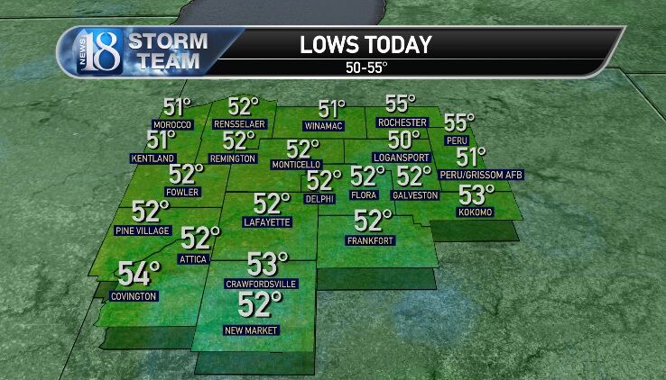


Lows this morning ran 50-55 with some patchy fog.

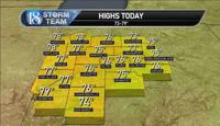
Highs today reached 73-79 with low humidity, but the smoky haze arrived late afternoon-evening.

_______________________________________
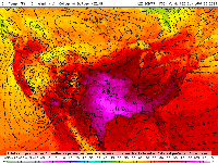
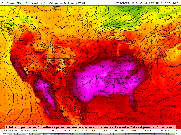
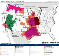
Flood Watches & Warnings are already lining up in the Southwest with extremely rare Tropical Storm Warning for California, while the building hot upper ridge shows up well in the Plains & parts of the Lower Mississippi Valley to Corn Belt.

_______________________________________
Hot ridge dominates our weather Sunday-Friday with highs highs largely 91-95 with heat indices not far from the actual temperature UNTIL Wednesday.
By Thursday-Friday, heat indices may reach 98-107.
Meanwhile, Hilary hits California & the Far West & potential Emily hits Texas.
We look to get an official heat wave here. At first it looked like the ridge would contract Thursday & we may get a few storms early with highs near 88. I am reverting back to my original idea of a true 5 days or greater stretch of 90 or better, which would classify it as a heat wave.


_______________________________________
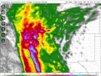
Major Hurricane Hilary will weaken to a tropical storm then make landfall near L.A. or San Diego. Flooding rainfall, storm surge, dangerous seas & strong winds will occur.
Note that a PRE-type event will occur ahead of the storm. PRE are Predecessor Rainfall Events that usually occur hours before the main area of the storm's rains arrive. They are often and arc of heavy rainfall &/or storms & do even impact our region when the remnants of a significant hurricane are approaching.

+2.50" rainfall amounts will extend as far north as Idaho & northwestern Montana with +6" rains in parts of southern California.

_______________________________________
We do see a cold front & upper trough dip southeastward. That will be induced as the Hilary remnants combine with a surface low over eastern Canada, causing it to deepen.
Meanwhile, the remnants of Emily in the Plains may bring deep moisture for showers & storms along the cold front next Saturday, August 26.

_______________________________________
Cooler weather follows with 74-77 Sunday & lows 50-54, followed by 78-82 Monday, August 28.

_______________________________________
A few showers & storms are possible around Tuesday, August 29 with highs in the 80s, but we will need to watch potential Hurricane Franklin on the Gulf Coast. The track of that hurricane will have big impacts on our weather.
It appears that upper jet will be way north, resulting in above normal temperatures then after August 29 through Labor Day weekend (80s & 90s).
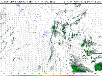
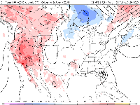
Upper level winds:

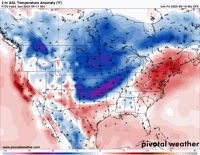
Temperature anomalies:

_______________________________________
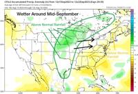
After below normal rainfall in early September (unless we see a tropical system wildcard with more in the way of rainfall), it looks wetter toward mid-September.

Below normal temperatures then arrive with a real chill of Fall, especially at night!
There will likely be early-season snow in the higher elevations of the eastern Rockies.
Temperatures should rebound in late September.