
Create successful ePaper yourself
Turn your PDF publications into a flip-book with our unique Google optimized e-Paper software.
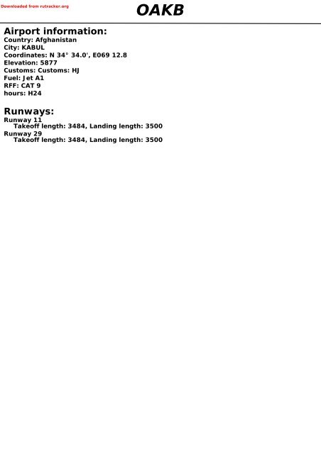
Downloaded from rutracker.org<br />
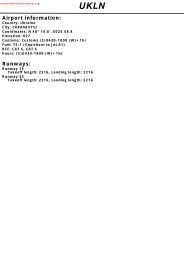
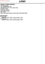
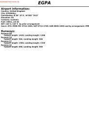
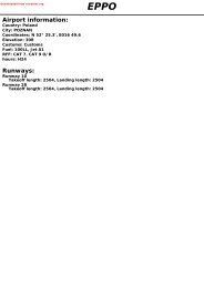
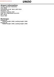
Airport information:<br />
Country: Afghanistan<br />
City: KABUL<br />
Coordinates: N 34° 34.0', E069 12.8<br />
Elevation: 5877<br />
Customs: Customs: HJ<br />
Fuel: Jet A1<br />
RFF: CAT 9<br />
hours: H24<br />
<strong>OAKB</strong><br />
Runways:<br />
Runway 11<br />
Takeoff length: 3484, Landing length: 3500<br />
Runway 29<br />
Takeoff length: 3484, Landing length: 3500
If you like to use this <strong>charts</strong>, please, buy a subscription for nDAC.<br />
For rutracker.org<br />
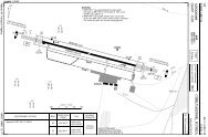
AERODROME<br />
Kabul DLV GND TWR<br />
135.275 1 134.5 129.4<br />
10 - 1 07 MAR 12<br />
ATIS<br />
130.15<br />
AD Elev 5877 ARP: N34 34.0 E069 12.8 RFF: CAT 9 AD HR: 2330 - 1830<br />
Afghanistan - <strong>OAKB</strong> / KBL<br />
INTL<br />
KABUL<br />
3E<br />
ELEV 5869<br />
E069 12 E069 13 E069 14<br />
1<br />
Check ATIS for active Clearance<br />
Delivery frequency.<br />
From 0730 - 0130 service will<br />
be provided by Ground 134.5.<br />
60m<br />
196ft<br />
11<br />
105°<br />
Warning<br />
LAND MINE HAZARD in<br />
proximity of RWY<br />
3500x50m 60m<br />
11482x164ft 196ft<br />
ELEV 5872<br />
N34<br />
34<br />
Warning<br />
Chart drawn using best<br />
available sources. Use<br />
with caution<br />
THR Coordinates<br />
RWY 11 N34 34.2 E069 11.6<br />
RWY 29 N34 33.7 E069 13.8<br />
TWR<br />
Terminal<br />
29<br />
285°<br />
6026<br />
0 500 1000m<br />
0 1000 2000 3000 4000ft<br />
RWY Slope TORA m/ ft LDA m/ ft ALS REDL Additional<br />
11 0 3500 / 11482 3500 / 11482 H-E 2 L -<br />
29 0 3500 / 11482 3500 / 11482 H-C L P (49) 3<br />
2 420m. 3 Unusable beyond 5° right of RCL.<br />
EU OPS<br />
RWY<br />
11/29<br />
TAKE OFF MINIMA<br />
Facilities<br />
RCL (day only) or RCL + REDL<br />
NIL (day only)<br />
RVR<br />
A B C D<br />
400m<br />
500m<br />
Navtech - oakb01laorg0<br />
10 - 1<br />
Change: New print<br />
THIS CHART IS A PART OF NAVIGRAPH CHARTS AND IS INTENDED FOR FLIGHT SIMULATION USE ONLY
If you like to use this <strong>charts</strong>, please, buy a subscription for nDAC.<br />
For rutracker.org<br />
10 - 2<br />
AERODROME<br />
Kabul DLV GND TWR ATIS<br />
135.275 1 134.5 129.4 130.15<br />
1 Check ATIS for active<br />
Clearance Delivery frequency.<br />
From 0730 - 0130 service will<br />
be provided by Ground 134.5.<br />
Overview<br />
10 - 2<br />
Apron 6<br />
Apron 5D<br />
B<br />
07 MAR 12<br />
A<br />
11<br />
105°<br />
J<br />
Apron 10<br />
Afghanistan - <strong>OAKB</strong> / KBL<br />
INTL<br />
KABUL<br />
N<br />
Terminal<br />
Apron 5C<br />
TWR<br />
Apron 5B<br />
Apron 4A<br />
Apron 3<br />
Apron 5A<br />
B<br />
B<br />
Apron 4B<br />
Helistrip<br />
B2<br />
Helistrip<br />
B1<br />
D<br />
D<br />
HS5<br />
HS3<br />
C<br />
E<br />
Apron<br />
7D<br />
Apron<br />
7C<br />
3500x50m / 11482x164ft<br />
K<br />
L<br />
HS4<br />
M<br />
H<br />
Apron 9C<br />
H Apron 9B<br />
H<br />
Apron 9A<br />
Helistrip<br />
H2<br />
Apron 8D<br />
Apron 8C<br />
Apron 8B<br />
Apron 8A<br />
Navtech - oakb02laorg0<br />
Warning<br />
Chart drawn using best<br />
available sources. Use<br />
with caution<br />
Hot Spots HS1-HS5<br />
Apron 2B<br />
Apron 2A<br />
Apron 7A<br />
There are five assigned Hot Spot Areas<br />
HS1-HS5 in accordance with Runway<br />
Incursion Prevention Program.<br />
Raised potential for RWY incursions<br />
or aircraft and/or vehicle traffic<br />
incidents. Pay extra attention inside<br />
these areas for possible traffic.<br />
Apron 1<br />
Apron 7B<br />
B<br />
R<br />
B<br />
F<br />
G<br />
N<br />
29<br />
285°<br />
H<br />
HS2<br />
HS1<br />
Helistrip<br />
H1<br />
Change: New print<br />
THIS CHART IS A PART OF NAVIGRAPH CHARTS AND IS INTENDED FOR FLIGHT SIMULATION USE ONLY
If you like to use this <strong>charts</strong>, please, buy a subscription for nDAC.<br />
For rutracker.org<br />
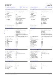
GENERAL<br />
10 - 3 21 SEP 11<br />
Afghanistan - <strong>OAKB</strong> / KBL<br />
INTL KABUL<br />
GENERAL<br />
1. TAXIWAY RESTRICTION<br />
1.1 Taxiway A, B, D and E 21m/69ft<br />
Taxiway C 20m/66ft<br />
Taxiway F 22m/72ft<br />
Taxiway G 18m/59ft<br />
1.2 FOD danger on all shoulders. Wide<br />
bodied, multi-engined aircraft are strongly<br />
recommended to taxi on inboard engines<br />
only.<br />
1.3 Ground movements and some parked<br />
aircraft may affect ILS signals for Runway<br />
29. ILS critical area not protected.<br />
2. COMMUNICATIONS<br />
Radio communication and the performance<br />
of NAVAIDs can be deteriorated at short<br />
notice.<br />
3. LIGHTING<br />
Airport lighting system can be expected to<br />
degrade at short notice.<br />
Runway 29 Sequence Flashing Lights are<br />
out of service.<br />
4. PREFERENTIAL RUNWAY<br />
Runway 29 will be used for all movements<br />
(unless otherwise required by ATC) in<br />
normal operating conditions when the<br />
tailwind component is 10kt, runway surface<br />
is dry or wet with braking action good.<br />
5. MINIMA<br />
IFR Take-off Minima. IFR take-off minima<br />
is as follows:<br />
a. From SR to SS: visibility 400m (500m<br />
with runway lights inoperative).<br />
b. From SS to SR: visibility 500m<br />
6. CAUTION<br />
6.1 Overfl ight of built-up areas is prohibited<br />
for rotary and fi xed wing aircraft below<br />
500 agl. Departing and arriving traffi c shall<br />
follow the runway direction accordingly<br />
till abeam departure end prior to initiating<br />
turn and avoid overfl ight of all aprons.<br />
6.2 Overfl ying taxiing aircraft is forbidden at an<br />
altitude lower than 500 agl.<br />
6.3 Meteorological balloon launched daily at<br />
1130 and 2330, SFC to 50,00ft agl.<br />
6.4 Unmanned Aerial Vehicle (UAV) traffi c<br />
within Kabul CTR. Contact Kabul TWR on<br />
129.4.<br />
6.5 Avoid 0.5nm/1km radius centred on<br />
N34 34.6 E069 14.4 SFC to 500 agl due<br />
controlled explosions.<br />
6.6 Short notice explosives ordnance disposal<br />
(EOD) activities occur within the vicinity of<br />
Kabul City and Kabul airport. All arrivals<br />
and departures must contact TWR on<br />
129.4 or 134.5.<br />
6.7 Jet Blast. Local controller and Ground<br />
controller must be aware at all times of the<br />
jet blast effect from heavy and medium jet<br />
engine aircraft. Before asking for start-up<br />
clearance ensure no other traffi c before<br />
taxiing.<br />
6.9 Traffic Pattern. Normal training fl ights<br />
and radio failure traffi c procedure will<br />
always follow traffi c pattern south except<br />
when otherwise approached by ATC.<br />
10 - 3<br />
oakb03gaorg0<br />
© Navtech -<br />
Aircraft Operation below IFR Approach<br />
Minima. If the weather condition is below<br />
IFR approach minima, ATC will report<br />
“weather condition below minima, expect<br />
holding or proceed to the alternate”. ATC<br />
TWR will issue landing clearance only if<br />
pilots reports runway in sight. It is solely<br />
the pilot’s responsibility to perform IFR<br />
approach below published IFR minima.<br />
Be prepared to enter hold and divert<br />
without prior notice.<br />
THIS Change: CHART New IS print. A PART OF NAVIGRAPH CHARTS AND IS INTENDED FOR FLIGHT SIMULATION USE ONLY
If you like to use this <strong>charts</strong>, please, buy a subscription for nDAC.<br />
For rutracker.org<br />
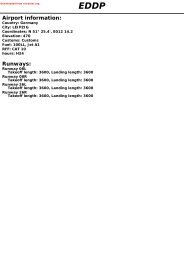
GENERAL<br />
10 - 4 10 MAR 10<br />
Afghanistan - <strong>OAKB</strong> / KBL<br />
KABUL<br />
oakb04gaorg0<br />
© Navtech -<br />
6.10 Due to increased bird activity, crews are<br />
strongly advised to switch all available lights<br />
ON below 1000 agl in the vicinity of the<br />
airport.<br />
Aircraft suffering a bird strike within the<br />
Kabul CTR must immediately report it to<br />
the appropriate ATS facility an at the fi rst<br />
possibility opportunity to KAIA Flight Safety<br />
Offi ce (FSO):<br />
In Person: Building 100, Room 031<br />
Via phone: +93 (0) 799 111 5104<br />
+93 (0) 799 1 3999 +688 3127<br />
Via E-mail: isafkiafsonu@apod-kaia.isaf.nato.int<br />
The submission of a written report to KAIA<br />
FSO is mandatory by using the standard<br />
ICAO Bird Strike Reporting Form.<br />
6.11 At Camp Souter FOB a high intensity radio<br />
transmission are (HIRTA) in band E has<br />
been established within the area bounded<br />
by arc radius (425m/1400ft from origin<br />
N34 32.9 E069 14.3 from surface to 820.<br />
6.12 Crews are advised to avoid overfl ying the<br />
tethered balloon at 1nm/1,9km radius,<br />
centred on N34 30.6 E069 11.5.<br />
7. REDUCED RUNWAY SEPARATION<br />
In general, clearance to land may be<br />
issued when the preceding landing aircraft<br />
has vacated the runway or when that is a<br />
reasonable assurance that the runway is<br />
clear of traffi c when the landing aircraft is<br />
passing landing threshold.<br />
8. TAXI PROCEDURES<br />
All aircraft shall adhere to ATC taxi and<br />
parking instructions. Pilots are responsible<br />
for apron positioning after leaving the main<br />
taxiway when not assisted by a Follow-Me<br />
or marshaller.<br />
All aircrews should be alert for uncontrolled<br />
pedestrian and vehicle traffi c at all times.<br />
Only after vacating the runway<br />
expeditiously, and entire aircraft is clear<br />
of the runway holding position, pilot shall<br />
immediately report ‘runway vacated’, On<br />
instruction by TWR, contact Ground for<br />
further taxi instructions.<br />
Due to Heavy helicopter traffi c on<br />
Taxiways B and H, do not enter these<br />
taxiways without explicit ATC clearance.<br />
The holding positions are named after the<br />
relevant taxiway, The maximum taxi speed<br />
shall not exceed 16kt. This speed shall<br />
be reduced in poor conditions, All aircraft<br />
shall display aircraft lights during taxi.<br />
ARRIVAL<br />
1. RADIO FAILURE PROCEDURES<br />
1.1 Arriving Aircraft. All traffc rotary/fi xed<br />
wing in case of radio failure and intended<br />
to join the traffi c patterns shall do it at 45<br />
degrees angle to the downwind leg. In radio<br />
failure situations the traffi c SHALL NEVER<br />
cross from north to south or vice versa over<br />
the airport, or the fi nal approach sectors,<br />
interfering with possible traffi c.<br />
1.2 Aircraft in flight. Aircraft/ATC should try<br />
to establish radio contact via 121.5. If not<br />
possible to establish radio contact through<br />
this means and if there is radar capability<br />
from ATC in order to identify if the pilot is<br />
receiving any radio transmissions from<br />
ATC, controllers shall ask, and pilots shall<br />
expect to be asked to:<br />
a. Acknowledge by IDENT, or<br />
b. Change Squawk<br />
If there is no radar follow this procedure:<br />
1.2.1 Medium/Heavy Aircraft. Low approach over<br />
the runway at or above 500 agl, look for<br />
TWR light gun signal and “fl ash landing<br />
lights” advising RADIO FAILURE. The<br />
join the TWR (south) traffi c pattern. When<br />
turning base leg or short fi nal look for<br />
light gun signal for full stop landing or go<br />
around, vacate runway in use after landing<br />
at Taxiway A/J or G (depending on runway<br />
in use). Do not enter Taxiway B/H without<br />
ATC clearance by radio frequency, light gun<br />
signal or follow-me guidance.<br />
1.3 In the probability that the communications<br />
failure is due to the mountainous terrain<br />
the controllers shall try to relay information<br />
through other aircraft fl ying in a coverage<br />
are of the aircraft behind mountains or<br />
fl ying too low. Use the same vice versa<br />
procedude to acknowledge information to<br />
ATC.<br />
THIS Change: CHART New IS Spec. A PART OF NAVIGRAPH CHARTS AND IS INTENDED FOR FLIGHT SIMULATION USE ONLY
If you like to use this <strong>charts</strong>, please, buy a subscription for nDAC.<br />
For rutracker.org<br />
GENERAL<br />
10 - 5 10 MAR 10<br />
Afghanistan - <strong>OAKB</strong> / KBL<br />
KABUL<br />
DEPARTURE<br />
1. RADIO FAILURE PROCEDURES<br />
1.1 Departing Aircraft. Departing aircraft shall<br />
attempt to contact Bagram Approach and<br />
continue outbound on previously assigned<br />
routeing.<br />
1.2 Aircraft on the Ground<br />
1.2.1 Aircraft taxiing for departure. Stop, hold<br />
current position on the taxiway, expect to<br />
return to parking position, keep engines<br />
running, and wait for follow-me vehicle<br />
guidance or light-gun signal to vacate the<br />
area.<br />
4. MINIMUM RUNWAY OCCUPANCY TIME<br />
On receipt of line-up clearance,<br />
commensurate with safety and standard<br />
operating procedures, taxi to the correct<br />
position at the hold and line up on the<br />
runway without delay. Whenever possible<br />
cockpit checks should be conducted<br />
prior to line up and any checks requiring<br />
completion while on the runway should<br />
be kept to a minimum. Commence<br />
take-off roll ASAP after receipt of take-off<br />
clearance.<br />
1.2.2 Aircraft lined-up for departure. Taxi down<br />
the runway, vacate at the earliest possible,<br />
then stop on the taxiway, and wait for<br />
Follow-Me vehicle guidance or light-gun<br />
signal. Do not enter Taxiway B/H without<br />
clearance via radio, light-gun or follow-me<br />
guidance.<br />
2. START-UP PROCEDURE<br />
Request clearance from Clearance<br />
Delivery 30mins prior to estimated off<br />
block time (EOBT). After receiving ATIS,<br />
request start-up clearance from Clearance<br />
Delivery/Ground Control. Start clearance<br />
will not be issued earlier than 20mins<br />
prior to estimated off block time (EOBT).<br />
Actual engine start shall be commenced<br />
immediately after requesting and<br />
acceptance of visual hand signals from<br />
the marshaller. Aircraft require pushback<br />
should be ready for taxi within 4min of<br />
EOBT. Request taxi clearance from Ground<br />
Control. Take into account taxi time to<br />
runway holding points and advice Tower of<br />
any delays in excess of 10mins.<br />
oakb05gaorg0<br />
© Navtech -<br />
3. INTERMEDIATE HOLDING POSITIONS<br />
Intermediate holding positions are<br />
established on Taxiway Bravo at Golf<br />
intersection and on Taxiway Hotel at<br />
November intersection. Medium and heavy<br />
jet engine aircraft cannot taxi beyond these<br />
positions unless cleared by Tower.<br />
Reverse side blank<br />
THIS Change: CHART New IS Spec. A PART OF NAVIGRAPH CHARTS AND IS INTENDED FOR FLIGHT SIMULATION USE ONLY
If you like to use this <strong>charts</strong>, please, buy a subscription for nDAC.<br />
For rutracker.org<br />
SID<br />
RNAV MURAD 2<br />
Kabul DLV GND TWR DEP APP ATIS<br />
135.275 1 134.5 129.4 132.5 131.6 130.15<br />
TA 14000 AD Elev 5877<br />
1<br />
Check ATIS for active Clearance<br />
Delivery frequency.<br />
From 0730 - 0130 service will<br />
be provided by Ground 134.5.<br />
30 - 1<br />
07 MAR 12<br />
Afganistan - <strong>OAKB</strong> / KBL<br />
INTL<br />
Warning<br />
Chart drawn using best<br />
available sources. Use<br />
with caution<br />
GPS Required<br />
RNAV 1<br />
DME/DME RNP 0.3 NA<br />
KABUL<br />
MURAD<br />
MNM<br />
N 34 31.0<br />
E069 04.0<br />
11200<br />
5 105°<br />
MURAD 2<br />
MURA2<br />
WIRID<br />
N34 32.2<br />
E069 19.6<br />
10 105°<br />
30 - 1<br />
PEGAL<br />
N34 29.2<br />
E069 31.2<br />
KEDAR TR<br />
210°<br />
24.6<br />
175<br />
ARP<br />
KEDAR<br />
MNM<br />
N 34 10.1<br />
E068 53.3<br />
12200<br />
0 5 10nm<br />
Navtech - oakb01daorg0<br />
MNM Climb Gradient:<br />
SID<br />
MURAD 2<br />
TRANSITION<br />
KEDAR<br />
5.9% to 11200 by MURAD and<br />
6.7% to 12200 by KEDAR.<br />
Routeing<br />
Climb on 105° to WIRID - PEGAL - turn left<br />
to MURAD<br />
Routeing<br />
MURAD - KEDAR. Maintain assigned ALT.<br />
Change: New print<br />
THIS CHART IS A PART OF NAVIGRAPH CHARTS AND IS INTENDED FOR FLIGHT SIMULATION USE ONLY
If you like to use this <strong>charts</strong>, please, buy a subscription for nDAC.<br />
For rutracker.org<br />
30 - 2 07 MAR 12<br />
SID RNAV WOVIS 1<br />
Kabul DLV GND TWR DEP APP ATIS<br />
135.275 1 134.5 129.4 132.5 131.6 130.15<br />
TA 14000 AD Elev 5877<br />
Afganistan - <strong>OAKB</strong> / KBL<br />
INTL<br />
KABUL<br />
Warning<br />
Chart drawn using best<br />
available sources. Use<br />
with caution<br />
1<br />
Check ATIS for active Clearance<br />
Delivery frequency.<br />
From 0730 - 0130 service will<br />
be provided by Ground 134.5.<br />
2<br />
CIMAB<br />
N34 35.4<br />
E069 07.1<br />
30 - 2<br />
2<br />
Spot height 7383 QNH<br />
RADAR and GPS required<br />
RNP 2<br />
TABDA<br />
N34 18.5<br />
E068 36.3<br />
TABDA TR<br />
254°<br />
22.8<br />
208°<br />
16.2<br />
KEDAR TR<br />
WOVI1<br />
195°<br />
11.7<br />
WOVIS 1<br />
WOVIS<br />
N34 24.2<br />
E069 03.0<br />
KODAD TR<br />
24.5 132°<br />
KEDAR<br />
N34 10.1<br />
E068 53.3<br />
OAR409<br />
Shan Ghar Range<br />
FL160<br />
H24<br />
KODAD<br />
N34 07.0<br />
E069 24.1<br />
175<br />
0 5 10nm<br />
ARP<br />
Navtech - oakb02daorg0<br />
NOTE: KEDAR TR N/A when OAR409 is active<br />
MNM CLIMB GRADIENT: 7.1% up to 12000 except KODAD TR up to 15500<br />
SID<br />
WOVIS 1<br />
TRANSITION<br />
KEDAR<br />
KODAD<br />
TABDA<br />
ROUTEING<br />
Climb direct CIMAB - turn left 195° - WOVIS<br />
ROUTEING<br />
WOVIS - KEDAR<br />
WOVIS - KODAD<br />
WOVIS - TABDA<br />
Change: New print<br />
THIS CHART IS A PART OF NAVIGRAPH CHARTS AND IS INTENDED FOR FLIGHT SIMULATION USE ONLY
If you like to use this <strong>charts</strong>, please, buy a subscription for nDAC.<br />
For rutracker.org<br />
SID<br />
30 - 3 07 MAR 12<br />
KABUL 2<br />
Kabul DLV GND TWR DEP APP ATIS<br />
135.275 1 134.5 129.4 132.5 131.6 130.15<br />
TA 14000 AD Elev 5877<br />
R307<br />
Afganistan - <strong>OAKB</strong> / KBL<br />
INTL<br />
KABUL<br />
Warning<br />
Chart drawn using best<br />
available sources. Use<br />
with caution<br />
RADAR or DME<br />
required<br />
R286<br />
2<br />
127°<br />
250kt<br />
MAX<br />
until R195 KBL<br />
MNM<br />
7000<br />
285°<br />
106°<br />
1<br />
2<br />
Check ATIS for active Clearance<br />
Delivery frequency.<br />
From 0730 - 0130 service will<br />
be provided by Ground 134.5.<br />
Spot height 7054 QNH<br />
4.6 nm from RWY 29<br />
Kabul<br />
D112.0 KBL<br />
N34 32.7<br />
E069 17.4<br />
30 - 3<br />
3<br />
Spot height 9022 QNH<br />
8.3 nm from RWY 11<br />
195°<br />
3<br />
175<br />
180<br />
0 5 10nm<br />
LOBRE<br />
D20 KBL<br />
N34 13.6<br />
E069 10.1<br />
090<br />
168<br />
KBL<br />
360<br />
161<br />
Navtech - oakb03daorg0<br />
Speed: MAX 250KT until R195 KBL.<br />
MNM Climb Gradient: RWY 11: 6.4% to 10900<br />
RWY 29: 7.4% to 9400<br />
SID<br />
KABUL 2<br />
RWY<br />
11<br />
29<br />
Routeing<br />
Climb on 106° / R286 KBL - turn right on<br />
R195 KBL - LOBRE. Maintain assigned ALT.<br />
Climb on 285° to 7000 - turn right on 127° / R307 KBL<br />
At KBL turn right on R195 KBL - LOBRE.<br />
Maintain assigned ALT.<br />
Change: New print<br />
THIS CHART IS A PART OF NAVIGRAPH CHARTS AND IS INTENDED FOR FLIGHT SIMULATION USE ONLY<br />
Reverse side blank
If you like to use this <strong>charts</strong>, please, buy a subscription for nDAC.<br />
For rutracker.org<br />
ILS RWY 29<br />
50 - 1 07 MAR 12<br />
Kabul APP Bagram APP Kabul ARR TWR GND ATIS<br />
131.6 127.925 132.5 129.4 134.5 130.15<br />
Afganistan - <strong>OAKB</strong> / KBL<br />
INTL<br />
KABUL<br />
TERPS<br />
ILS/DME 110.5 I - AKW FAT 285° THR Elev 5872 AD Elev 5877 TL 160 TA 14000<br />
7054<br />
D20<br />
KBL<br />
E069 10 E069 20 E069 30<br />
D9<br />
KBL 7000<br />
7215<br />
5888 5973<br />
5970<br />
6930<br />
3E<br />
287°<br />
R422<br />
Kabul<br />
12000<br />
195°<br />
MAPt D0.2 I-AKW<br />
MAX<br />
5941<br />
7200<br />
14000<br />
13000<br />
Kabul<br />
D112.0 KBL<br />
MAX 265kt<br />
015°<br />
6034<br />
7000<br />
195°<br />
9022<br />
D10<br />
KBL<br />
9630<br />
6329<br />
6530<br />
10nm<br />
Climb on R287 KBL ,<br />
at D9 KBL turn right to KBL at<br />
MNM 11200. Proceed on R195 KBL<br />
continue climb to 13000 to D10 KBL and hold.<br />
MNM Climb Gradient: 4.7% to 11200.<br />
Warning<br />
Chart drawn using<br />
best available<br />
sources.<br />
Use with caution<br />
1<br />
7421<br />
6243<br />
FAP<br />
HIGEL<br />
D10.6 I-AKW<br />
D402<br />
CDS Kamari<br />
12500<br />
285°<br />
7000<br />
9000<br />
ILS/DME<br />
STICH<br />
D12 I-AKW<br />
7000<br />
D10.6<br />
HIGEL<br />
I-AKW<br />
110.5 I-AKW<br />
Emerg safe alt<br />
100nm 21700 QNH<br />
9900<br />
3.5°<br />
11043<br />
D12<br />
STICH<br />
I-AKW<br />
Radar or DME required<br />
VGSI and descent<br />
angle not coincident<br />
9870<br />
Scale distorted<br />
MYLOE<br />
D14 I-AKW<br />
LEELO<br />
D17 I-AKW<br />
D14<br />
MYLOE<br />
I-AKW<br />
285°<br />
9000<br />
090<br />
D17<br />
LEELO<br />
I-AKW<br />
MAX<br />
14000<br />
D30<br />
KBL<br />
106°<br />
MAX 265kt<br />
IAF<br />
WEBRO<br />
D20 KBL<br />
175<br />
168<br />
FL160<br />
180<br />
KBL<br />
360<br />
286°<br />
N34<br />
40<br />
1<br />
161<br />
7000<br />
N34<br />
20<br />
D20<br />
WEBRO<br />
KBL R-105<br />
14000<br />
10200 10600 11200<br />
50 - 1<br />
oakb01iaip00<br />
STATE<br />
TCH 55<br />
ACFT<br />
A<br />
B<br />
C<br />
ILS<br />
6360<br />
(474)<br />
1600m C<br />
0 1 2 3 4 5 6 7 8 9 10 11 12 13 14 15 16 17 18 19 20 nm<br />
Note: Circling NA<br />
LDA 3500x50<br />
11482x164ft<br />
C 500ft<br />
P (49)<br />
Navtech -<br />
D<br />
FALS<br />
Change: New print<br />
THIS CHART IS A PART OF NAVIGRAPH CHARTS AND IS INTENDED FOR FLIGHT SIMULATION USE ONLY
If you like to use this <strong>charts</strong>, please, buy a subscription for nDAC.<br />
For rutracker.org<br />
VOR RWY 29<br />
50 - 2 07 MAR 12<br />
Kabul APP Bagram APP Kabul ARR TWR GND ATIS<br />
131.6 127.925 132.5 129.4 134.5 130.15<br />
Afganistan - <strong>OAKB</strong> / KBL<br />
INTL<br />
KABUL<br />
TERPS<br />
VOR/DME 112.0 KBL FAT 282° THR Elev 5872 AD Elev 5877 TL 160 TA 14000<br />
E069 107000 7215<br />
E069 20 E069 30<br />
5888<br />
5973<br />
7421<br />
7054<br />
9870<br />
RALOY 5970<br />
6329 6243<br />
D8 KBL 5941<br />
6530<br />
R422 6930<br />
Kabul<br />
12000<br />
7200<br />
6034<br />
Kabul<br />
D112.0 KBL<br />
287°<br />
195°<br />
9022<br />
OKRUE MIGAH<br />
D2.5 KBL D6 KBL<br />
10nm<br />
D402<br />
CDS Kamari<br />
12500<br />
7000<br />
282°<br />
KEEMO<br />
D10.2 KBL<br />
11043<br />
7000<br />
MAX 265kt<br />
MIBEE<br />
D20 KBL<br />
Scale distorted<br />
3E<br />
D36<br />
KBL<br />
MAX 102°<br />
FL180<br />
14000<br />
282°<br />
IAF<br />
LANNI<br />
D28 KBL<br />
Radar or DME required<br />
Final App intersects<br />
RCL 3.3nm from THR<br />
50 - 2<br />
Scale distorted<br />
LOBRE<br />
D20 KBL<br />
015°<br />
FL230<br />
FL170<br />
MAX<br />
MAX 265kt<br />
195°<br />
MAPt KBL<br />
Climb on R287 KBL .<br />
At RALOY D8 KBL turn right to<br />
KBL Proceed on R195 KBL<br />
continue climb to<br />
to LOBRE and hold.<br />
MNM Climb Gradient:<br />
4.6% to 11200.<br />
D32<br />
KBL<br />
9630<br />
Warning<br />
Chart drawn using best<br />
available sources. Use<br />
with caution<br />
OKRUE<br />
KBL D2.5 KBL<br />
3.5°<br />
MIGAH<br />
D6 KBL<br />
1<br />
9000<br />
Emerg safe alt<br />
100nm 21700 QNH<br />
KEEMO<br />
D10.2 KBL<br />
FL170 10800<br />
9200<br />
7900<br />
11000<br />
090<br />
175<br />
168<br />
180<br />
KBL<br />
360<br />
MIBEE<br />
D20 KBL<br />
1<br />
7000<br />
N34<br />
20<br />
LANNI<br />
D28 KBL<br />
282°<br />
161<br />
Btn<br />
FL180<br />
14000<br />
11000<br />
oakb02iaip00<br />
STATE<br />
Navtech -<br />
ACFT VOR+DME Circling a<br />
A<br />
7080 (1203)<br />
6.0km C<br />
B<br />
7300 (1423)<br />
6680 (803)<br />
6.0km C<br />
6000m C<br />
C<br />
7540 (1663)<br />
6.0km C<br />
D<br />
GS<br />
ROD 3.5°<br />
80<br />
490<br />
100<br />
620<br />
120<br />
740<br />
140<br />
860<br />
1 2 3 4 5 6 7 8 9 10 11 12 13 14 15 16 17 18 19 20 21 22 23 24 27 28<br />
a North of RWY 11/29<br />
DME 3.5° LDA 3500x50<br />
KBL ALT 11482x164ft<br />
C VOR/DME: 900ft<br />
P (49)<br />
10.2<br />
C Circling:<br />
CAT A: 1300ft<br />
8<br />
CAT B: 1500ft<br />
6<br />
CAT C/D: 1700ft<br />
4<br />
2<br />
1<br />
160<br />
980<br />
MAPt<br />
1.0<br />
10800<br />
10000<br />
9270<br />
8530<br />
7800<br />
7430<br />
7070<br />
6680<br />
Change: New print<br />
THIS CHART IS A PART OF NAVIGRAPH CHARTS AND IS INTENDED FOR FLIGHT SIMULATION USE ONLY<br />
FALS
If you like to use this <strong>charts</strong>, please, buy a subscription for nDAC.<br />
For rutracker.org<br />
RNAV (GPS) RWY 29<br />
50 - 3 07 MAR 12<br />
Kabul APP Bagram APP Kabul ARR TWR GND ATIS<br />
131.6 127.925 132.5 129.4 134.5 130.15<br />
Afghanistan - <strong>OAKB</strong> / KBL<br />
INTL<br />
KABUL<br />
RNAV FAT 285° THR Elev 5872 AD Elev 5877 TL 160 TA 14000<br />
3E E069 10 E069 20 E069 30 E069 40<br />
DME/DME RNP 0.3 NA<br />
LUBEK<br />
7000<br />
9870<br />
Warning<br />
Chart drawn using best<br />
available sources. Use<br />
with caution<br />
9000<br />
N34<br />
40<br />
TERPS<br />
SIXER<br />
7054 7000 7215<br />
5888 RWY29<br />
5970<br />
5941<br />
5973 6329<br />
7421<br />
WIRID<br />
9870<br />
NAKOE<br />
5nm<br />
7000<br />
7200<br />
6034<br />
9022<br />
10n m<br />
5 5 3 7<br />
7000<br />
9630<br />
1<br />
7969<br />
KOVME<br />
9000<br />
Emerg safe alt<br />
100nm 21700 QNH<br />
11043<br />
285°<br />
165<br />
1<br />
RWY<br />
29<br />
IAF<br />
LENTE<br />
091°<br />
12500<br />
271°<br />
N34<br />
30<br />
50 - 3<br />
MAPt RWY29<br />
Climb on 285° to<br />
12500 to SIXER,<br />
turn right to LUBEK,<br />
then right to LENTE<br />
and hold.<br />
RWY29<br />
2.8nm<br />
to THR<br />
RW29<br />
WIRID<br />
7800<br />
NAKOE KOVME<br />
10600<br />
9800<br />
285°<br />
LENTE<br />
12500<br />
oakb03iaip00<br />
STATE<br />
Navtech -<br />
ACFT LNAV Circling a<br />
A<br />
6980 (1103) 7080 (1203)<br />
1500m C 2.0km C<br />
B<br />
6980(1103)<br />
7300 (1423)<br />
1600m C 2.4km C<br />
C<br />
6980 (1103) 7540 (1663)<br />
D<br />
4000m C 4.8km C<br />
GS<br />
ROD 3.6°<br />
80<br />
520<br />
100<br />
650<br />
120<br />
780<br />
0 1 2 3 4 5 6 7 8 9 10 11 12 13 14 15 16 17 18 19 20 nm<br />
a North of RWY 11/29<br />
C LNAV: 1200ft<br />
C<br />
140<br />
910<br />
Circling:<br />
CAT A: 1300ft<br />
CAT B: 1500ft<br />
CAT C/D: 1700ft<br />
160<br />
1040<br />
THR 3.6°<br />
29 ALT<br />
LDA 3500x50<br />
11482x164ft<br />
P (49)<br />
Change: New print<br />
THIS CHART IS A PART OF NAVIGRAPH CHARTS AND IS INTENDED FOR FLIGHT SIMULATION USE ONLY<br />
12.1<br />
10<br />
8<br />
6<br />
5<br />
4<br />
3<br />
2.7<br />
10600<br />
9800<br />
9030<br />
8250<br />
7870<br />
7480<br />
7090<br />
6980<br />
FALS<br />
Reverse side blank