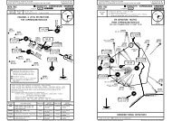
lcra/akt akrotiri, cyprus lcra/akt akrotiri, cyprus - German Flight-Center
lcra/akt akrotiri, cyprus lcra/akt akrotiri, cyprus - German Flight-Center
lcra/akt akrotiri, cyprus lcra/akt akrotiri, cyprus - German Flight-Center

Create successful ePaper yourself
Turn your PDF publications into a flip-book with our unique Google optimized e-Paper software.
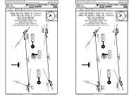
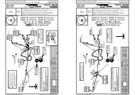
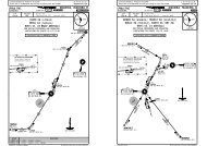
Licensed to Elefant air. Printed on 15 Jul 2009.Notice: After 17 Jul 2009 0901Z, this chart may no longer be valid. Disc 13-2009LCRA/AKT32-5834-35.632-58.16 7 8 9 10APRON A29 AUG 0834-35.5 5 4 3 2 1JEPPESEN10-9A32-58.2 32-58.3 32-58.4CAUTION:Deceptive surfacesfollow centerlines.JEPPESENJeppView 3.6.3.0AKROTIRI, CYPRUSAKROTIRI ABB CentralRWY 10/28Main Taxiway34-35.5BRIEFING STRIP TMLicensed to Elefant air. Printed on 15 Jul 2009.Notice: After 17 Jul 2009 0901Z, this chart may no longer be valid. Disc 13-2009LCRA/AKTAKROTIRI AB*AKROTIRI Approach (R)*AKROTIRI TowerJEPPESEN11-1123.6 1 120.4 1125.5 126.3LOCFinalGSILSApch CrsDA(H) Apt Elev 76'IAKNo AltitudeRefer to*109.7 284^publishedMinimums TDZE 76'MISSED APCH: Climb AHEAD to 2080' (2004'), then turn LEFT onto220^, climbing as directed.QNH QFE16 NOV 07*Ground122.1TACAN AzimuthRequiredJEPPESENJeppView 3.6.3.0AKROTIRI, CYPRUSILS DME Rwy 28NICOSIA RadarAlt Set: hPa ( on Final)Trans level: By ATC Trans alt: 8000'1. Overflight of hospital 3 NM SW of apt prohibited below 2000' QFE. 2. Subject to the appropriate visualreferences being achieved at DH, the ILS beam structure is suitable for auto-coupled approaches to the rwy thr.3. ILS DME reads zero at rwy 28 threshold.180^8700' 7300'090^ 270^1400'MSA AKR TACAN34-35.432-5834-35.1B WestFREIGHT32-58.1 32-58.2 32-58.3 32-58.4APRON E654APRON B11.523TERMINALB East34-35.432-58.534-35 5APRON G 34-3534-34.9Acft will normally enter andexit the Apron B accordingto the parking slot allocated.32-59.7CHANGES: None.APRON DInner Taxiway32-59.8 32-59.9 33-00.133-001098172634Inner twy is unsuitablefor wide bodied acft.Q1234533-0032-59.7 32-59.8 32-59.933-00.1678933-00.233-00.2INS COORDINATESSTAND No. COORDINATES STAND No. COORDINATESA Apron6N34 35.0 E032 59.81 thru 34, 5N34 35.5 E032 58.2N34 35.5 E032 58.17, 89, 10N34 35.1 E032 59.8N34 35.1 E032 59.96, 7N34 35.6 E032 58.18 thru 10 N34 35.5 E032 58.2G Apron1, 2N34 35.1 E033 00.1B Apron3 thru 8 N34 35.0 E033 00.11, 1.52, 34, 56N34 35.5 E032 58.5N34 35.4 E032 58.5N34 35.4 E032 58.4N34 35.5 E032 58.49Q ShedN34 35.0 E033 00.2N34 35.1 E033 00.11, 23 thru 5E ApronN34 35.1 E032 59.9N34 35.0 E032 59.934-35.134-34.9| JEPPESEN, 1998, 2003. ALL RIGHTS RESERVED.5 05 10TERPS34-40LC(D)-2LC(D)-234-30535'220^LC(R)-AKROTIRILC(D)-11LC(R)-AKROTIRILC(D)-2LC(D)-11LC(D)-10LC(R)-AKROTIRILC(D)-35LC(R)-AKROTIRILC(D)-10LC(R)-AKROTIRILC(D)-10CAT A & B 104^CAT C & D32-50 33-00D13.0/R-120 AKR TAC(IAF)LOCIAK DME1.02.0 3.04.0(GS out) ALTITUDE (HAT) 450' (374') 770' (694') 1090' (1014') 1410' (1334')TCH 53'690'TAC-107AKROTIRIA K R1562'D* (116.0) AKRD0.5 IAKTDZE 76'0.54.25.0Gnd speed-Kts 70 90 100 120 140 160 HIALS2080'ILS GS 3.00^orPAPI PAPI (2004')LOC Descent Gradient 5.2%MAP at D0.5 IAK.JAR-OPS. STRAIGHT-IN LANDING RWY 28CIRCLE-TO-LANDILSLOC (GS out)A: 306'(230') C: 326'(250')DA(H)Prohibited North of rwy 10/28B: 316'(240') D: 336'(260') MDA(H) 370'(294')MaxFULL ALS outALS out Kts MDA(H)VISA90 660'(584') 1500mRVR 1500mB RVR 600mRVR 1000m RVR 800m120 660'(584') 1600mCRVR 1600m 140 760'(684') 2400mD RVR 650mRVR 1200m RVR 1200m RVR 1800m 165 780'(704') 3600m377 485 539 647 755 862CHANGES: LOC ident. ILS DME established. Procedure.D0.5IAK11253'In event of serious interference on APP/TWR freqrelay messages via NICOSIA Radar.284^D4.7IAKD4.7 IAK284^109^D9.7 IAKD11.5 AKR TAC2080(IF)587'ILS DME284^ I *109.7 A K IAK100^13 DME ArcAKR TACD9.7 IAKD11.5 AKR TAC1580'(1504')| JEPPESEN SANDERSON, INC., 1998, 2007. ALL RIGHTS RESERVED.1580
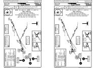
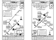
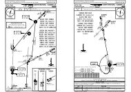
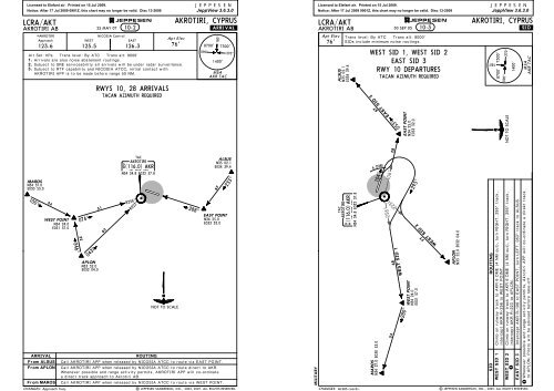
Licensed to Elefant air. Printed on 15 Jul 2009.Notice: After 17 Jul 2009 0901Z, this chart may no longer be valid. Disc 13-2009BRIEFING STRIP TMDA(H)/MDA(H)Refer toMinimumsLC(D)-35JEPPESENJeppView 3.6.3.0JEPPESENLCRA/AKTAKROTIRI, CYPRUS16 NOV 07AKROTIRI AB 18-1 *PAR or *SRE Rwy 10, 28*AKROTIRI Approach123.6 1 123.6 123.3X 125.7 123.3X 120.4 1FinalApt Elev 76'RADAR Apch CrsTDZE 10By ATCTDZE 28QNH QFE*AKROTIRI Director*AKROTIRI Talkdown (PAR)GSNo Alt publishedMinimum AltNo FAFMissed Approach - See below690'*AKROTIRI Tower*Ground122.171'76'Alt Set: hPa Trans level: By ATC Trans alt: 8000'1. Fixed wing acft are to avoid the "deadside" area to the North of AKROTIRIup to 5800' AGL. 2. Overflight of hospital 3 NM SW of apt prohibited below 2000' QFE.3. ILS DME reads zero at rwy 28 threshold.1266'NICOSIA Radar125.5 126.3180^8700' 7300'090^ 270^1400'MSAAKR TACAN587'5 05TERPS34-40535'LC(D)-2TAC-107AKROTIRIA K RD*(116.0) AKRLC(R)-AKROTIRILC(D)-11LC(R)-AKROTIRILC(D)-2Floodlighttowers193'In event of serious interference on APP/TWR freqrelay messages via NICOSIA Radar.LC(R)-AKROTIRILC(D)-10LC(D)-11LC(R)-AKROTIRILC(D)-10LC(R)-AKROTIRILC(D)-1032-50 33-00 33-1034-30MISSED APCH:RWY 10: Climb on rwy track to 2080' (2009'), then turn RIGHT onto 220^, climbingas directed.284^WARNING: Floodlight towers 193' contained within Missed Approach segment. Missed Approach surfaceoriginates at DA(H) point. No allowance made for level surface before Missed Approach climb.RWY 28: Climb on rwy track to 2080' (2004'), then turn LEFT onto 220^, climbing asdirected.Missed apch when LC(D)-2 is active: Immediately climb to 2080' (2004'), when passing 1580' (1504')turn immediately LEFT onto track 130^, or as directed.1ILS DME284^ I *109.7 A K IAKPAR TCH: GS 2.5^-49', GS 3.0^-58'.Gnd speed-Kts 70 90 100 120 140 160Lighting- Refer toPAR GS2.50^ 315 405 450 541 631 721See Missed ApchPAR GS3.00^ 377 485 539 647 755 862Airport Chart aboveMAP 1.0 NM from touchdown.JAR-OPS. PAR 10 GS 3.00^ STRAIGHT-IN LANDINGPAR 10PAR 10 GS 2.50^DA(H) C: 341'(270') PAR 28 A: 306'(230') C: 326'(250') Azimuth onlyDA(H)DA(H)301'(230') 1 D: 351'(280')B: 316'(240') D: 336'(260') MDA(H) 420'(349')ALS outALS outALS outALS outA RVR700mRVR1000mRVR 700m RVR1000mRVR1200mRVR1500mBRVR 600mRVR 1000m RVR1300mNOTCRVR800mRVR1200mRVR1400mRVR1800mAUTHORIZEDDRVR 650mRVR 1200m RVR1600mRVR 2000m.JAR-OPS.STRAIGHT-IN LANDINGCIRCLE-TO-LANDPAR 28Azimuth onlySRE 10SRE 28Prohibited NorthMDA(H) 340'(264') MDA(H) 570'(499') MDA(H) 510'(434')of rwy 10/28MaxALS outALS outALS out Kts MDA(H)VISARVR 1400mRVR 900m90 660'(584') 1500mRVR 1500mRVR 1500mRVR 1500mB RVR 800mRVR 1500m120 660'(584') 1600mRVR1000mCRVR 1600m RVR 1600mRVR 1800m 140 760'(684') 2400mRVR 2000mD RVR 1200m RVR 1800m RVR 1800mRVR1400mRVR 2000m 165 780'(704') 3600m1 DA(H) CAT A: 321'(250'), CAT B: 331'(260').CHANGES: LOC ident. ILS DME established. MM withdrawn.| JEPPESEN SANDERSON, INC., 1998, 2007. ALL RIGHTS RESERVED.