
Create successful ePaper yourself
Turn your PDF publications into a flip-book with our unique Google optimized e-Paper software.
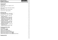
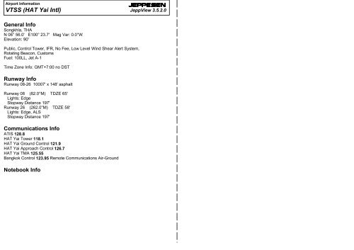
Airport Information<strong>VTSS</strong> (<strong>HAT</strong> <strong>Yai</strong> <strong>Intl</strong>)JEPPESENJeppView 3.5.2.0General InfoSongkhla, THAN 06° 56.0' E100° 23.7' Mag Var: 0.0°WElevation: 90'Public, Control Tower, IFR, No Fee, Low Level Wind Shear Alert System,Rotating Beacon, CustomsFuel: 100LL, Jet A-1Time Zone Info: GMT+7:00 no DSTRunway InfoRunway 08-26 10007' x 148' asphaltRunway 08 (82.0°M) TDZE 65'Lights: EdgeStopway Distance 197'Runway 26 (262.0°M) TDZE 58'Lights: Edge, ALSStopway Distance 197'Communications InfoATIS 128.8<strong>HAT</strong> <strong>Yai</strong> Tower 118.1<strong>HAT</strong> <strong>Yai</strong> Ground Control 121.9<strong>HAT</strong> <strong>Yai</strong> Approach Control 126.7<strong>HAT</strong> <strong>Yai</strong> TMA 125.55Bangkok Control 123.95 Remote Communications Air-GroundNotebook Info
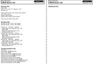
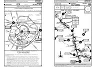
Licensed to max. Printed on 22 Jun 2008.Notice: After 4 Jul 2008 0901Z, this chart may no longer be valid. Disc 12-2008<strong>VTSS</strong>/HDY90'Apt ElevN06 56.0 E100 23.716 MAY 08JEPPESEN10-9JEPPESENJeppView 3.5.2.0SONGKHLA, THAILAND<strong>HAT</strong> YAI INTLATIS <strong>HAT</strong> YAI Ground Tower128.8 121.9 118.1Licensed to max. Printed on 22 Jun 2008.Notice: After 4 Jul 2008 0901Z, this chart may no longer be valid. Disc 12-2008<strong>VTSS</strong>/HDYJEPPESEN16 MAY 08 10-9AE100-23.5E100-23.6JEPPESENJeppView 3.5.2.0SONGKHLA, THAILANDE100-23.7<strong>HAT</strong> YAI INTL100-23100-24100-2506-57During IMC, wide body aircraft may be requested to holdon apron for other wide body aircraft landing and takingoff, due to minimum separation distances between runway06-57centerline and centerline of parallel Taxiway A (394' 120m)and Taxiway K (492' 150m), used by military.Runway 08 right traffic pattern.FOR PARKING POSITIONSSEE REVERSE SIDEBldgAreaMETControl Tower01^WN06-56.27654321NDBNAVOR E D C BF06-56 AH A C BGK06-56IJJ Elev 197'60mL58' StopwayARPM08082^3050m197'60mStopwayElev 65'10,007'Taxiway A not available when the aircrafttake off and landing category is C, D or E.26262^Taxiways K, L, J, and M for military use.N06-56.1N06-56.0ENDNCNN06-56.1BN06-56.0A06-55 Feet 0 1000 2000 3000 4000 500006-55Meters 0 500 1000 1500AACB100-23100-24100-25ADDITIONAL RUNWAY INFORMATIONUSABLE LENGTHSLANDING BEYONDRWYThreshold Glide Slope TAKE-OFF WIDTH08 HIRL PAPI (angle 3.0^)RVR148'26 HIRL SSALF PAPI (angle 3.0^)45mSTAND No.1, 23, 4E100-23.5 E100-23.6 B E100-23.7 CPARKING STAND COORDINATESCOORDINATES STAND No. COORDINATESN06 56.2 E100 23.7N06 56.1 E100 23.65 thru 7 N06 56.1 E100 23.5TAKE-OFFABCDLVP must be in forceAll RwysRCLM (Day only)or RLRVR 250mRVR 300mAIR CARRIER (JAA)All RwysRCLM (Day only)or RLRVR 400m2Eng3 & 4EngAIR CARRIER (FAR 121)All RwysAdequate Vis RefRVR 500mVIS 400mParking stand 1 for aircraft up to A300Parking stands 2, 3, 4 for aircraft up to B747-400Parking stands 5, 6, 7 for aircraft up to B737CHANGES: Lighting.| JEPPESEN, 2003, 2008. ALL RIGHTS RESERVED.CHANGES: None.| JEPPESEN, 2003, 2008. ALL RIGHTS RESERVED.
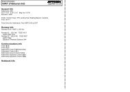
| JEPPESEN SANDERSON, INC., 1997, 2006. ALL RIGHTS RESERVED.| JEPPESEN SANDERSON, INC., 1997, 2006. ALL RIGHTS RESERVED.Licensed to max. Printed on 22 Jun 2008.Notice: After 4 Jul 2008 0901Z, this chart may no longer be valid. Disc 12-2008<strong>VTSS</strong>/HDYJEPPESEN10 MAR 06 10-9BJEPPESENJeppView 3.5.2.0SONGKHLA, THAILAND<strong>HAT</strong> YAI INTLALLOCATION OF AIRCRAFT PARKING BAYSAll aircraft parking bays are allocated by the Ground/Apron controller withregard to the aircraft type involved and the prevailing or anticipated trafficsituation.AIRCRAFT MARSHALLING AND TOWING SERVICESThe marshalling of scheduled, non-scheduled and casual aircraft into the bays,either manually or by the aid of the RLG Guide-in system, and the pushing out ofaircraft for departure shall be the responsibility of the aircraft operator or it'sappointed ground handling agency.TAXIING PROCEDURESWhen IMC exists, wide body aircraft may be requested to hold on the apron forother wide body aircraft landing or taking off. This is due to the minimumseparation distance between the centrelines of the runway and the paralleltaxiways Alpha and Kilo, which are 120m and 150m respectively.a. Arriving Aircraft - Aircraft entering the aprons are to follow closely thetaxiway and apron centrelines so as to avoid reducing safe distances betweenthemselves and other aircraft.b. Departing Aircraft - When start-up clearance is issued by ATC, aircraft arethen pushed out onto the apron centreline.START UP PROCEDURESIFR aircraft are to call Ground Control 5 minutes prior to start up to request ATCclearance. Pilots are to inform Ground Control of their call sign (and proposedflight level if different from the flight plan) when making the call. Once the flightlevel is accepted by the pilot, and an ATC clearance is issued, the aircraft mustbe ready to taxi within 5 minutes, otherwise the ATC clearance will be cancelled.RLG AUTOMATED GUIDE-IN SYSTEMa. The RLG Automated Guide-in system is installed at aircraft parking bays 2and 3.b. The system enables the pilot seated on the left of the cockpit to position theaircraft on the correct stand centreline and stop position.c. The following types of aircraft are programmed into the system:B767B757B747-SPB747-400B737B727B707DC-8DC-8SDC-9DC-10PILOT OPERATING INSTRUCTIONSA300A310A320L1011-5L1011-1IL 62a. Aircraft Type Identification - Confirm that your aircraft type is displayedcorrectly and the round green lamps are illuminated before entering the gate.Discontinue docking if the wrong aircraft type is illuminated. (Ground crewshall check/reset system or marshall aircraft into bay.)b. Centreline Guidance - Look at the bottom half of the housing and interpretthe vertical neon lights as shown below:Licensed to max. Printed on 22 Jun 2008.Notice: After 4 Jul 2008 0901Z, this chart may no longer be valid. Disc 12-2008<strong>VTSS</strong>/HDYJEPPESEN10 MAR 06 10-9CRLG AUTOMATED GUIDE-IN SYSTEM(Cont)JEPPESENJeppView 3.5.2.0SONGKHLA, THAILAND<strong>HAT</strong> YAI INTLc. Stopping Guidance - Look at the round incandescent lamps on the top half ofthe housing and interpret as shown below:STEADY GREEN - RAMP CLEARSTEADY AMBER - SLOW DOWN 15' (4.5 m)TO STOPSTEADY RED- STOPThe amber (caution) lights will extinguish and the round red (stop) lights willilluminate simultaneously when the aircraft is in the correct stopping position.This will allow the rear edge of the aircraft door to clear the airbridge collarwhen opened. CAUTION: the aircraft has from 1 ft. 1 in. (0.33m) to 4 ft.(1.31m), depending on the aircraft type, to its maximum stopping positionbefore the aircraft door will foul the airbridge collar when the door is opened.d. Discontinue docking immediately should the lights go off. If any light fails, theentire system will automatically shut off and the aircraft will be towed ormarshalled into the bay. The ground crew has back-up manual controls whichwill preempt automatic controls should emergency stopping be necessary, or tocomplete guide-in procedures manually should the apron sensors becomeinoperative.UPPERHOUSINGBOTTOMHOUSINGDiagram of the RLG Automated Guide-In SystemDIGITAL DISPLAYGREEN (START)AMBER (CAUTION)RED (STOP)GREEN NEON TUBE(GL)RED NEON TUBES(OFF LEFT OR RIGHT)REDGREEN GREEN GREENREDLIGHT HOUSINGLEFT OF CENTRELINE -STEER TOWARDS GREENAIRCRAFT ONCENTRELINERIGHT OF CENTRELINE -STEER TOWARDS GREEN
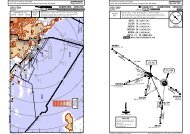
178^178^358^358^A457A457BRIEFING STRIP TMPANS OPS 3Licensed to max. Printed on 22 Jun 2008.Notice: After 4 Jul 2008 0901Z, this chart may no longer be valid. Disc 12-2008<strong>VTSS</strong>/HDYJEPPESEN<strong>HAT</strong> YAI INTL27 JUL 07 11-1307^330^345^HTY 115.3307^003^163^162^101^112^072^JEPPESENJeppView 3.5.2.0SONGKHLA, THAILANDILS or LOC Rwy 26ATIS <strong>HAT</strong> YAI Approach (R) <strong>HAT</strong> YAI Tower Ground128.8 126.7 118.1121.9LOCFinalGSDA(H)Apt ElevIHTY Apch CrsD7.8 IHTY90'D7.0 HTY Refer to109.9 263^ 1950'(1892') Minimums RWY 26 58'4200'MISSED APCH: Climb STRAIGHT AHEAD to 600' then turn RIGHT and continueclimbing to 3000' and hold at D7.8 IHTY or as directed by ATC.Alt Set: hPa Rwy Elev: 2 hPa Trans level: FL130Trans alt: 11000'1. IHTY and HTY DME required.W17W14D25.0HTY2179'2(IAF)SADAOD14.0 HTY5000D20.0HTYD20.0HTY2804'3016'107^093^D132^CHANGES: Procedure.W28W143059'127^003^15000(IAF)HTY183^<strong>HAT</strong> YAI115.3 HTYAPPROACH TRANSITIONS1 3IHTY DME(IAF)PHALAD14.0 HTY500058'343^A464A 464342^(IAF)POSAID14.0HTYAPPROACHTRANSITIONS981'(IAF)SAMETD14.0 HTY5000D M E A r c H T YW 65 0100-20003^183^2SADAO(IAF) 2PHALA1 (IAF)POSAID14.0 HTY50002(IAF)SAMET13 DME Arc3000650' 1444' 1047'1102'909'263^1555'D12.013ArcDME531'1050'1950'5.0MaxKts1001351802053000909'334^VT(D)-50CAT C & D077^ CAT A & B314^3000089^1873'060^MSA HTY VOR094^100-40320^CAT A & BCAT C & DVT(D)-49| JEPPESEN SANDERSON, INC., 2007. ALL RIGHTS RESERVED.145^3600'292^505'281^3000'A33407-1007-00W1 4(IAF)LANKAD17.0 HTY 06-505000ALTITUDE 740'1060' 1360' 1680'VOR5000'D12.0 D12.8 IHTYHTYTCH 53'(CHABA)105^RWY 26 0.5 0.8 2.6Gnd speed-Kts 70 90 100 120 140 160ILS GS 3.00^ or377 484 538 646 753 861or LOC Descent Gradient 5.2%MAP at D3.3 IHTY FAF to MAP 4.5 3:51 3:00 2:42 2:15 1:56 1:41STRAIGHT-IN LANDING RWY 26ABCDILSDA(H) ABC:258'(200') D:260'(202')FULL1200mcD3.3 IHTYHTYD2.5MMALS outD3.3IHTY D7.8IHTYD2.5HTY HTYD7.0MM105^(IAF)263^1360'1.9LOC (GS out)MDA(H) 520'(462')ALS out2400m083^D5.9 IHTYD5.1HTYD5.9 IHTYD5.1 HTY30003000D7.8 IHTYD7.0 HTYHTYMAX 4000HTYILS DME263^ i h 109.9 t yIHTYD12.8IHTYD12.0HTY263^600'(IF)HTY(IAF)PRADUD17.0 HTY50001522'1411'4.0 5.0 6.0 7.0PAPISALSPAPIRT3000'3000' D7.8CIRCLE-TO-LANDMDA(H)600'(510')-2400m700'(610')-2400m700' (610')-3600mIHTYBRIEFING STRIP TMPANS OPS 3Licensed to max. Printed on 22 Jun 2008.Notice: After 4 Jul 2008 0901Z, this chart may no longer be valid. Disc 12-2008<strong>VTSS</strong>/HDYJEPPESEN<strong>HAT</strong> YAI INTL27 JUL 07 13-1307^330^345^HTY 115.3307^003^163^162^101^112^073^JEPPESENJeppView 3.5.2.0SONGKHLA, THAILANDVOR Rwy 26ATIS <strong>HAT</strong> YAI Approach (R) <strong>HAT</strong> YAI Tower Ground128.8 126.7 118.1121.9VORFinal Minimum Alt MDA(H) Apt Elev 90'HTYApch Crs D7.01950'(1892') 550'(492') RWY 26 58'115.3 264^MISSED APCH: Climb STRAIGHT AHEAD to 1000' then turn RIGHT and continueclimbing to 3000' and hold at D7.0 or as directed by ATC.Alt Set: hPa Rwy Elev: 2 hPa Trans level: FL130Trans alt: 11000'1. HTY DME required.W17W14D25.0HTY2D20.0HTYD20.0HTY3016'D(IAF)SADAOD14.0 HTY500058'CHANGES: Procedure.MDA(H) 550'(492')MaxKts1001351802055.0078^090^060^MSA HTY VORCAT C & DCAT A & B095^320^VT(D)-50CAT A & BCAT C & DVT(D)-49| JEPPESEN SANDERSON, INC., 2007. ALL RIGHTS RESERVED.145^4200'3600'ALTITUDE 680'1000' 1310' 1630'VORD12.05000'3000'D7.0D2.61950'RWY 26W28107^093^W14132^127^003^15000(IAF)HTY183^<strong>HAT</strong> YAI115.3 HTYAPPROACH TRANSITIONS(IAF)PHALAD14.0 HTY5000343^A 464342^(IAF)POSAID14.0HTYAPPROACHTRANSITIONS(IAF)SAMETD14.0 HTY50001.4105^4.4MAP at D2.6FAF to MAP 4.4 3:51 3:00 2:42 2:15 1:56 1:41STRAIGHT-IN LANDING RWY 26264^Gnd speed-Kts 70 90 100 120 140 160SALS1000'Descent Gradient 5.2% 369 474 527 632 737 843ABCD2179'2804'3059'1 3HTY DME(CHABA)A464981'W 65 0100-20D M E A r c H T Y2600m003^183^(IAF)D2.62SADAO(IAF) 2PHALA1 (IAF)POSAID14.0 HTY5000D7.0084^2 (IAF)SAMET13 DME Arc3000650' 1444'1047'105^1102'ALS out909'MAX 40003000264^1555'D12.03000531'13 DME Arc1411'PAPI3000909'D12.0332^(IF)311^3000(IAF)PRADUD17.0 HTY50001522'1050'PAPI1873'100-40292^3.0 4.0 5.0 6.0RTCIRCLE-TO-LANDMDA(H)600'(510')-2600m700'(610')-2600m700' (610')-3600m505'281^3000'A33407-1007-00W1 4(IAF)LANKAD17.0 HTY06-5050003000'D7.0
Licensed to max. Printed on 22 Jun 2008.BRIEFING STRIP TMNotice: After 4 Jul 2008 0901Z, this chart may no longer be valid. Disc 12-2008<strong>VTSS</strong>/HDY<strong>HAT</strong> YAI INTLATIS27 JUL 07<strong>HAT</strong> YAI Approach (R)003^JEPPESEN13-2128.8126.7118.1VORFinal Minimum Alt MDA(H)HTYApch Crs D5.8Refer to Apt Elev 90'115.3 183^ 1950' (1860') MinimumsMISSED APCH: Climb STRAIGHT AHEAD to 650' then turn LEFT andcontinue climbing to D12.0 at 3000' and hold or as directed by ATC.183^(IAF)KOYAID20.0(IF)D12.0D5.8<strong>HAT</strong> YAI TowerAlt Set: hPa Apt Elev: 3 hPa Trans level: FL130Trans alt: 11000'1. HTY DME required.07-1007-00600'574'2133'2804'3016'716'3059'758'981'3000650'<strong>HAT</strong> YAID115.3 HTYJEPPESENJeppView 3.5.2.0SONGKHLA, THAILANDVOR-A909'1444'719'531'909'1047'Ground121.9145^4200'060^3600'3000'320^MSA HTY VOR1873'VT(D)-50505'BRIEFING STRIP TMLicensed to max. Printed on 22 Jun 2008.Notice: After 4 Jul 2008 0901Z, this chart may no longer be valid. Disc 12-2008<strong>VTSS</strong>/HDY<strong>HAT</strong> YAI INTLATIS128.8VORHTY200^27 JUL 07<strong>HAT</strong> YAI Approach (R)126.7JEPPESEN13-3170^<strong>HAT</strong> YAI TowerJEPPESENJeppView 3.5.2.0SONGKHLA, THAILANDVOR-B118.1MDA(H)Apt Elev 90'FinalApch CrsNo FAFRefer to115.3 225^MinimumsMISSED APCH: Climb STRAIGHT AHEAD to 1000' then turn LEFT tointercept and proceed along R-200 HYT VOR outbound to 1800',then turn LEFT to intercept and proceed along R-170 HYT VORinbound to HTY VOR at 3600' and hold or as directed by ATC.Alt Set: hPa Apt Elev: 3 hPa Trans level: FL130Trans alt: 11000'07-003059'06-501668'981'045^3600350^1102'650'225^<strong>HAT</strong> YAID115.3 HTY1444'Ground121.9145^4200'060^1555'3600'3000'320^MSA HTY VOR531'1555'100-10 100-20 100-30 100-40HTY DME2.0 3.0 4.0 5.0ALTITUDE 780'1090' 1410' 1720'VOR D12.0D5.81950'3000'KOYAID20.05000'183^VOR1522'100-20 100-30045^225^1600' 15 NMStart turnat1CAT A & B 21CAT C & D 22 Min1 MinAPT.90'5.86.28.0650'3000'Gnd speed-Kts 70 90 100 120 140 160Lighting -Descent Gradient 5.2% 369 474 527 632 737 843Refer toD12.0MAP at VOR AirportChartLTFAF to MAP 5.8 4:58 3:52 3:29 2:54 2:29 2:10STRAIGHT-IN LANDINGCIRCLE-TO-LANDMAP at VORAPT.90'STRAIGHT-IN LANDINGLighting -Refer toAirportChart1000'CIRCLE-TO-LAND1800'LTviaHTY115.3200^PANS OPS 3ABCDNOT AUTHORIZEDMaxKts100135180205MDA(H)600'(510')-1600m700'(610')-2400m700'(610')-3600mPANS OPS 3ABCDNOT AUTHORIZEDMaxKts100135180205MDA(H)600'(510')-1600m700'(610')-2400m700'(610')-3600mCHANGES: New procedure.| JEPPESEN SANDERSON, INC., 2007. ALL RIGHTS RESERVED.CHANGES: New procedure.| JEPPESEN SANDERSON, INC., 2007. ALL RIGHTS RESERVED.
BRIEFING STRIP TMLicensed to max. Printed on 22 Jun 2008.Notice: After 4 Jul 2008 0901Z, this chart may no longer be valid. Disc 12-2008<strong>VTSS</strong>/HDY27 JUL 07<strong>HAT</strong> YAI INTLATIS128.8NDBHY328<strong>HAT</strong> YAI Approach (R)126.7MISSED APCH: Climb STRAIGHT AHEAD to 700' then turn LEFT tointercept and proceed along bearing 200^ HY NDB outbound to2100', then turn LEFT to intercept and proceed along bearing 173^from HY NDB inbound to 4200' and hold or as directed by ATC.Alt Set: hPaFinalApch Crs210^Apt Elev: 3 hPaNo FAFJEPPESENJeppView 3.5.2.0SONGKHLA, THAILAND16-1 NDB-CJEPPESENTrans level: FL130<strong>HAT</strong> YAI Tower118.1MDA(H)Apt Elev 90'Refer toMinimumsTrans alt: 11000'Ground121.9145^4200'060^3600'3000'320^MSA HTY VOR165^909'981'345^210^650'1444'1047'07-003059'210^030^<strong>HAT</strong> YAIDHTY 115.3 HTY531'4200030^<strong>HAT</strong> YAI328 HY200^1555'353^06-501668'NDB4200'1102'100-20 100-30030^210^2100' 15 NMStart turnatCAT A & B 3 MinCAT C & D 2 MinMAP at NDBAPT.90'STRAIGHT-IN LANDINGLighting -Refer toAirportChart700' 2100' HYvia 328LT 200^CIRCLE-TO-LANDPANS OPS 3ABCDCHANGES: New procedure.NOT AUTHORIZEDMaxKts100135180205MDA(H)600'(510')-1600m700'(610')-2400m700'(610')-3600m| JEPPESEN SANDERSON, INC., 2007. ALL RIGHTS RESERVED.