RNAV RWY 25 RNAV RWY 25
RNAV RWY 25 RNAV RWY 25
RNAV RWY 25 RNAV RWY 25
- No tags were found...

Create successful ePaper yourself
Turn your PDF publications into a flip-book with our unique Google optimized e-Paper software.
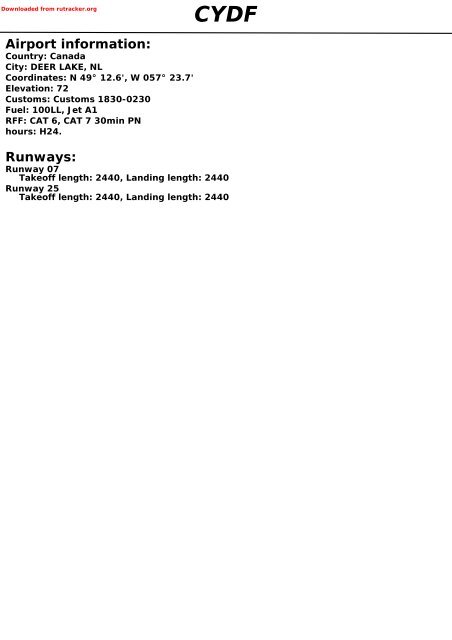
Downloaded from rutracker.orgAirport information:Country: CanadaCity: DEER LAKE, NLCoordinates: N 49° 12.6', W 057° 23.7'Elevation: 72Customs: Customs 1830-0230Fuel: 100LL, Jet A1RFF: CAT 6, CAT 7 30min PNhours: H24.CYDFRunways:Runway 07Takeoff length: 2440, Landing length: 2440Runway <strong>25</strong>Takeoff length: 2440, Landing length: 2440
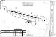
If you like to use this charts, please, buy a subscription for nDAC.For rutracker.orgAERODROME10 - 110 JUL 13Deer Lake RADIO Gander Centre DEP122.2 134.6Mandatory within 5nm below 3100ftAD Elev 72 ARP: N49 12.6 W057 23.7 RFF: CAT 6 (CAT 7, 30min PN) AD HR: H24W057 <strong>25</strong> W057 24 W057 23Canada (NL) - CYDF / YDFDEER LAKE10 - 121W<strong>25</strong>248°N4913ELEV 72ELEV 72Apron 2Apron 1BA2440x46m8005x150ftTHR Coordinates<strong>RWY</strong> 07 N49 12.1 W057 24.4<strong>RWY</strong> <strong>25</strong> N49 13.0 W057 <strong>25</strong>.9ELEV 57ELEV 4407068°0 500 1000mN49120 1000 2000 3000 4000ftNavtech - cydf01laorg0cydf01laorc0<strong>RWY</strong> Slope TORA m/ ft LDA m/ ft ALS REDL Additional07 +0.4 2440 / 8005 2440 / 8005 H-H H P 3°<strong>25</strong> - 0.4 2440 / 8005 2440 / 8005 H-I H -STATE TP 308TAKE OFF MINIMARVR / VIS<strong>RWY</strong> Facilities A B C D07/<strong>25</strong> aStandard RCL + REDLRVO 2600 1200 ft / ½¼sm07/<strong>25</strong> aaStandard 2600 ft / ½sm07: No LEFT turn below 1400 ASL.a <strong>25</strong>: 07: No MNM LEFT Climb turn Gradient below 1400 4.8% ASL. (290 ft/NM) to 1900. Climb <strong>RWY</strong> HDG to 1200 BPOC.<strong>25</strong>: MNM or Climb Gradient 4.8% (290 ft/NM) to 1900. Climb <strong>RWY</strong> HDG to 1200 BPOC.SPEC or VIS: Climb visual over AD to1300BPOC.For SPEC Take Off VIS and (Cat Alternate A 1sm, conditions Cat B 1½sm, see: Cat C/D 2sm): Climb visual over AD to 1300 BPOC.Note: Flight For Information Take Off and Supplement Alternate AER conditions Section see: under Canada or Canada RAR.Flight Information Supplement AER Section under Canada or Canada RAR.GENERAL INFORMATION1. CAUTION 2. SPEEDWater tower 2<strong>25</strong>, 1nm N of THR <strong>25</strong> MAX <strong>25</strong>0kt below 10000ft.Reverse side blankChange:New ADTHIS CHART IS A PART OF NAVIGRAPH CHARTS AND IS INTENDED FOR FLIGHT SIMULATION USE ONLY
If you like to use this charts, please, buy a subscription for nDAC.For rutracker.orgWEF 10 JAN 1330 - 1SID DEER LAKE 8Deer Lake RADIO Gander Centre DEP122.2134.6Mandatory within 5nm below 3100ftTA 18000 AD Elev 7204 DEC12St. Anthony D113.7 YAYCanada (NL) - CYDF / YDFDEER LAKEV381DEER LAKE 8CYDF8039°600030 - 1067°V382247°<strong>25</strong>7°FINNIN49 00.1W057 44.4<strong>25</strong>4500Deer lakeD113.3 YDFN49 14.0W057 12.8121°5000V38452 140°9000V382Gander 280 QX0 5 10 15nm36YDFIKBUNN48 48.0W056 03.9Navtech - cydf01daorg0NOTE: <strong>RWY</strong> 07: No left turns below 1400 .SPEED: MAX <strong>25</strong>0kt below 10000ft.MNM CLIMB GRADIENT: <strong>RWY</strong> <strong>25</strong>: 4.8% upto 1900.ALT RESTRICTION: Climb and maintain 6000 or as assigned.SIDDEER LAKE 8<strong>RWY</strong>AllRouteingClimb on <strong>RWY</strong> HDG for RAD vectors.COM FAIL: In the event of COM FAIL 10min or less after TKOF and IMC proceed as follows.1. Transponder Mode A/3 7600.2. Upon reaching last assigned ALT proceed directly on course.3. Maintain this ALT for 10min after TKOF.4. Climb to flight planned ALT.Note: If COM FAIL occurs more than 10min after TKOF, comply with the appropriate procedure forCOM FAIL ENR.Change: New ADTHIS CHART IS A PART OF NAVIGRAPH CHARTS AND IS INTENDED FOR FLIGHT SIMULATION USE ONLYReverse side blank
If you like to use this charts, please, buy a subscription for nDAC.For rutracker.orgILS OR NDB <strong>RWY</strong> <strong>25</strong>Gander Centre ARR Deer Lake RADIO134.6 122.<strong>25</strong>0 - 1Mandatory within 5nm below 3100ft10 JUL 13ILS 110.3 IDF /NDB 335 FK FAT 247° TDZ Elev 72 AD Elev 72 TL ATC TA 18000Canada (NL) - CYDF / YDFDEER LAKE21WW057 30 W057 20 W057 10 W057 002198200010nmIAFXOVUBR008D13 YDF Arc<strong>25</strong>00202°R040247°GUDAPD12.2 YDFTERPS1000Junction335 FK067°317°022°4.2ILS110.3 IDFWithin 13nm FKTransition DF to FK via070° , 7.7nm, MNM 2300D13 YDF Arc3000N49202200Deer Lake350 DFDeer LakeD113.3 YDF1000582At074°11873700678<strong>25</strong>4°10001000370901801600FK3533270R140IAFXIKODN491050 - 1cydf01iaipc0TP 308Navtech -MAPt4nm after FK / THRClimb on 247° to 3700 ,turn right to DF .MEAFKR317 YDF067°129011 LOC: AA: 3.5°TCH 500 1 2 3 4 5 6 7 8 9 10 11 12 13 14 15 16 17 18 nmACFT ILS+NDB LOC+NDB NDB Circling GS 80 100 120 140 160 LDA 2440x46680 (608)8005x150ftAROD 3.5° 500 620 740 870 9901¾smFAF +20s 1440 1400 1360 1320 1280720 (648)B 280 (200) 480 (408) 680 (608)2sm +40s 1280 1190 1110 1030 9501 2sm 1sm 1¼sm 760 (688)C+60s 1110 990 870 740 -2smFAF- 680 1:52 1:29 1:14 1:04 0:56920 (848)D2½sm FAF- 480 2:16 1:49 1:31 1:17 1:08FAF-MAPt 3:00 2:24 2:00 1:43 1:30247°2.7°PTN left within13nm of FK1600,2200SeeChartFALSChange: NewTHIS CHART IS A PART OF NAVIGRAPH CHARTS AND IS INTENDED FOR FLIGHT SIMULATION USE ONLY
If you like to use this charts, please, buy a subscription for nDAC.For rutracker.orgNDB <strong>RWY</strong> 07Gander Centre ARR Deer Lake RADIO134.6 122.<strong>25</strong>0 - 2Mandatory within 5nm below 3100ft10 JUL 13NDB 350 DF FAT 078° TDZ Elev 57 AD Elev 72 TL ATC TA 18000W057 40 W057 30 W057 20Canada (NL) - CYDF / YDFDEER LAKEN492021W100010nm1000At3700TERPS10001706582<strong>25</strong>8°<strong>25</strong>8°678Deer LakeD113.3 YDFN4910Within 10nm YDF17101627123°303°078°MEDLAD13.8 YDF1187Deer Lake350 DFD10.1 YDF50 - 2100037DF090 270332800123°303°PTN right within10nm DF.D13.8 YDFMEDLA22002.7°078°DFD10.1 YDF<strong>25</strong>8°1000MEAMAPt D7.8 YDF / THRClimb on 078° to 3700 ,turn left to DF .Navtech - cydf02iaipc0TP 308nm 17 16 15 14 13 12 11 10ACFT NDB+DMEAB 680 (623)2smCDCircling680 (608)1 3 4sm720 (648)2sm760 (688)2sm920 (848)2½sm9876543210LDA 2440x468005x150ftP 3°FALSChange: NewTHIS CHART IS A PART OF NAVIGRAPH CHARTS AND IS INTENDED FOR FLIGHT SIMULATION USE ONLY
If you like to use this charts, please, buy a subscription for nDAC.For rutracker.org<strong>RNAV</strong> (GNSS) <strong>RWY</strong> 07Gander Centre ARR Deer Lake RADIO134.6 122.221WMandatory within 5nm below 3100ft<strong>RNAV</strong> WAAS CH80095 W07A FAT 067° TDZ Elev 57 AD Elev 72 TL ATC TA 18000Canada (NL) - CYDF / YDFDEER LAKEW057 50 W057 40 W057 30 W057 20 W057 102198100050 - 310 JUL 13N492010nm1000TERPS10001000LENELBETUKRW071706 582DAMOX678ADREK171010003.1 2.51DELBI4067°2600247°N4910162728005 157°067°118710006cydf03iaipc0TP 308Navtech -1 LNAV only2 AA: 3.4° LNAVnm 17ACFTABCD16GSROD 3.4°SeeChart15LPV1000141000131000IAF/ IFGABABGABAB12067°11380 (323) 520 (463)1sm 1½sm80490100610LNAV1207301091408508337°<strong>25</strong>001000751900Circling680 (608)1¾sm720 (648)2sm760 (688)2sm920 (848)2½sm160970DAMOX653°42TEXOXSDFLENEL100031RW07LDA 2440x468005x150ftP 3°Change: NewTHIS CHART IS A PART OF NAVIGRAPH CHARTS AND IS INTENDED FOR FLIGHT SIMULATION USE ONLY211000010002110200037MAPt1600N4900RW07Climb on 067° to 2600via BETUK to DELBI.Shuttle climb to 2900,BPOC.THR 3.4°07 ALT7.56.7654321.22800<strong>25</strong>002270191015501180820520TCH 50FALS50 - 3
2.53.5If you like to use this charts, please, buy a subscription for nDAC.For rutracker.org<strong>RNAV</strong> (GNSS) <strong>RWY</strong> <strong>25</strong>Gander Centre ARR Deer Lake RADIO134.6 122.2Mandatory within 5nm below 3100ft<strong>RNAV</strong> WAAS CH80065 W<strong>25</strong>A FAT 247° TDZ Elev 72 AD Elev 72 TL ATC TA 1800021WW057 30 W057 20 W057 102198200010nm50 - 4OMVIX10 JUL 1320005 157°Canada (NL) - CYDF / YDFDEER LAKE1000IFERBAXN492061000247°337°TERPS1000IKNIB20005DUSPU1000MIPEG0.5nm toRW<strong>25</strong>SATUG067°5823300247°4.767838N491050 - 4UDBEX1187MIPEGMAPt MIPEG / 0.5nm to RW<strong>25</strong>Climb on 247° to 3300via SATUG to UDBEX.Shuttle climb as required.3°IKNIB1400247°ERBAX2000SeeChartcydf04iaipc0TP 308Navtech -TCH 50 0 1 2 3 4 5 6 7 8 9 10 11 12 nmACFT LPV LNAV CirclingTHR 3.0° LDA 2440x46<strong>25</strong> ALT 8005x150ftA680 (608)5.9 20001¾smB 390 (318) 540 (468)5 17201sm 1sm(628)C7004 14002sm3 1090(788)D8602½sm2 7701.3 540GS 80 100 120 140 160ROD 3.0° 430 540 640 750 860Change: NewTHIS CHART IS A PART OF NAVIGRAPH CHARTS AND IS INTENDED FOR FLIGHT SIMULATION USE ONLYFALS
If you like to use this charts, please, buy a subscription for nDAC.For rutracker.orgVOR A50 - 5 10 JUL 13Gander Centre ARR Deer Lake RADIO134.6 122.2Mandatory within 5nm below 3100ftVOR/DME 113.3 YDF FAT 283° AD Elev 72 TL ATC TA 18000Canada (NL) - CYDF / YDFDEER LAKEW057 30 W057 20 W057 10 W057 00 W056 5021W21982000100010nmTERPSAt5822900093°1000678Deer LakeD113.3 YDF10.1 093°3000283°121°076°301°<strong>25</strong>6°Within D10 YDFBISGAD10 YDF10001873N4920N49101187273°Deer Lake350 DF1000353°R1401335001000211010002000160036YDF2172COGLND21 YDFN490050 - 5MAPt D6.7 YDFClimb on 283° to 2900 ,turn left to DF .MEA283°YDF121°1700301°3000PTN left withinD10 YDFSeeChartNavtech - cydf05iaipc0TP 308ACFTABCDVOR+DME Circling780 (708)2¼sm920 (848)2½sm0 1 2 3 4 5 6 7 8 9 10 11 12 13 14 15 16 17 18 19 20 nmReverse side blankChange: NewTHIS CHART IS A PART OF NAVIGRAPH CHARTS AND IS INTENDED FOR FLIGHT SIMULATION USE ONLY