

OM Part C AIRFIELD BRIEFINGS Section 2 Page |1 ... - Astra Airlines
OM Part C AIRFIELD BRIEFINGS Section 2 Page |1 ... - Astra Airlines
OM Part C AIRFIELD BRIEFINGS Section 2 Page |1 ... - Astra Airlines

You also want an ePaper? Increase the reach of your titles
YUMPU automatically turns print PDFs into web optimized ePapers that Google loves.
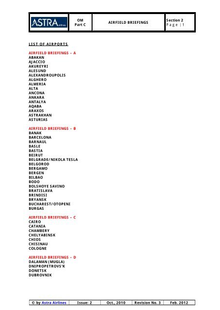
LIST OF AIRPORTS<br />
<strong>AIRFIELD</strong> <strong>BRIEFINGS</strong> – A<br />
ABAKAN<br />
AJACCIO<br />
AKUREYRI<br />
ALESUND<br />
ALEXANDROUPOLIS<br />
ALGHERO<br />
ALMERIA<br />
ALTA<br />
ANCONA<br />
ANKARA<br />
ANTALYA<br />
AQABA<br />
ARAXOS<br />
ASTRAKHAN<br />
ASTURIAS<br />
<strong>AIRFIELD</strong> <strong>BRIEFINGS</strong> – B<br />
BANAK<br />
BARCELONA<br />
BARNAUL<br />
BASLE<br />
BASTIA<br />
BEIRUT<br />
BELGRADE/NIKOLA TESLA<br />
BELGOROD<br />
BERGAMO<br />
BERGEN<br />
BILBAO<br />
BODO<br />
BOLSHOYE SAVINO<br />
BRATISLAVA<br />
BRINDISI<br />
BRYANSK<br />
BUCHAREST/OTOPENI<br />
BURGAS<br />
<strong>AIRFIELD</strong> <strong>BRIEFINGS</strong> – C<br />
CAIRO<br />
CATANIA<br />
CHAMBERY<br />
CHELYABINSK<br />
CHIOS<br />
CHISINAU<br />
COLOGNE<br />
<strong>AIRFIELD</strong> <strong>BRIEFINGS</strong> – D<br />
DALAMAN (MUGLA)<br />
DNIPROPETROVS'K<br />
DONETSK<br />
DUBROVNIK<br />
<strong>OM</strong><br />
<strong>Part</strong> C<br />
<strong>AIRFIELD</strong> <strong>BRIEFINGS</strong><br />
<strong>Section</strong> 2<br />
P a g e | 1<br />
© by <strong>Astra</strong> <strong>Airlines</strong> Issue: 2 Oct., 2010 Revision No. 3 Feb. 2012
<strong>AIRFIELD</strong> <strong>BRIEFINGS</strong> – E<br />
ELEFSIS<br />
<strong>AIRFIELD</strong> <strong>BRIEFINGS</strong> – F<br />
FAGERNES<br />
FIGARI<br />
FRANKFURT<br />
FUERTEVENTURA<br />
FUNCHAL<br />
<strong>AIRFIELD</strong> <strong>BRIEFINGS</strong> – G<br />
GENEVA<br />
GENOA<br />
GERONA<br />
GIBRALTAR<br />
GRANADA<br />
GRAZ<br />
GRENOBLE<br />
<strong>OM</strong><br />
<strong>Part</strong> C<br />
<strong>AIRFIELD</strong> <strong>BRIEFINGS</strong> – H<br />
HELSINKI<br />
HARSTAD/NARVIK (EVENES)<br />
HERAKLION (IRAKLION)<br />
<strong>AIRFIELD</strong> <strong>BRIEFINGS</strong> – I<br />
IOANNINA<br />
IZMIR (ADNAN MENDERES)<br />
<strong>AIRFIELD</strong> <strong>BRIEFINGS</strong> – K<br />
KALAMATA<br />
KARPATHOS<br />
KASTORIA<br />
KATOWICE<br />
KAZAN<br />
KEFALLINIA<br />
KEMEROVO<br />
KERKYRA<br />
KHANIA<br />
KHARKIV<br />
KIEV (BORISPOL)<br />
KIEV/ZHULIANY<br />
KLAGENFURT<br />
KOS<br />
KOSICE<br />
KRAKOW<br />
KRASNODAR, PASHKOVSKY<br />
KRASNOYARSK<br />
KRISTIANSAND<br />
KRK ISLAND (RIJEKA)<br />
KURUMOCH/SAMARA<br />
<strong>AIRFIELD</strong> <strong>BRIEFINGS</strong><br />
<strong>Section</strong> 2<br />
P a g e | 2<br />
© by <strong>Astra</strong> <strong>Airlines</strong> Issue: 2 Oct., 2010 Revision No. 3 Feb. 2012
<strong>AIRFIELD</strong> <strong>BRIEFINGS</strong> – L<br />
LASHAM<br />
LAJES (TERCEIRA ISLAND)<br />
LA CORUNA<br />
LAMEZIA TERME<br />
LANZAROTE (ARRECIFE)<br />
LA PALMA<br />
LEEDS BRADFORD<br />
LJUBLJANA<br />
LUXOR<br />
LUHANSK INTERNATIONAL<br />
L'VIV<br />
<strong>AIRFIELD</strong> <strong>BRIEFINGS</strong> – M<br />
MADRID/BARAJAS<br />
MAGNITOGORSK<br />
MALAGA<br />
MARSEILLE<br />
MIKONOS<br />
MILAN/MALPENSA<br />
MITILINI<br />
MOSCOW/D<strong>OM</strong>ODEDOVO<br />
MOSCOW/SHEREMETIEVO<br />
MUNICH<br />
<strong>AIRFIELD</strong> <strong>BRIEFINGS</strong> – N<br />
NAPLES<br />
NICE<br />
NIZHNY NOVGOROD<br />
NOVOSIBIRSK<br />
NURNBERG<br />
<strong>AIRFIELD</strong> <strong>BRIEFINGS</strong> – O<br />
ODESA<br />
OLBIA<br />
<strong>OM</strong>SK TSENTRALNY<br />
ORAN<br />
ORENBURG<br />
OSLO/GARDEMOEN<br />
OVDA<br />
<strong>AIRFIELD</strong> <strong>BRIEFINGS</strong> – P<br />
PALERMO<br />
PALMA<br />
PERPIGNIAN<br />
PLOVDIV<br />
PISA<br />
PODGORICA<br />
POPRAD<br />
PORTO SANTO<br />
PRAGUE<br />
PREVEZA<br />
PULA<br />
<strong>OM</strong><br />
<strong>Part</strong> C<br />
<strong>AIRFIELD</strong> <strong>BRIEFINGS</strong><br />
<strong>Section</strong> 2<br />
P a g e | 3<br />
© by <strong>Astra</strong> <strong>Airlines</strong> Issue: 2 Oct., 2010 Revision No. 3 Feb. 2012
<strong>AIRFIELD</strong> <strong>BRIEFINGS</strong> – R<br />
REYKJAVIK<br />
RHODES<br />
RIGA<br />
RIJEKA<br />
RIMINI<br />
ROSHCHINO<br />
ROSTOV<br />
<strong>OM</strong><br />
<strong>Part</strong> C<br />
<strong>AIRFIELD</strong> <strong>BRIEFINGS</strong> – S<br />
SAINT PETERSBURG<br />
SALONIKA (THESSALONICA)<br />
SALZBURG<br />
SAMOS<br />
SANKT-PETERBURG<br />
SANTA MARIA<br />
SANTANDER<br />
SANTORINI (THIRA)<br />
SARATOV/TSENTRANLY<br />
SHARM EL/SHEIKH<br />
SKIATHOS<br />
SKOPJE<br />
SOCHI<br />
SOFIA<br />
SPLIT<br />
STUTTGART<br />
SYLT<br />
<strong>AIRFIELD</strong> <strong>BRIEFINGS</strong> – T<br />
TARBES (LOURDES)<br />
TBILISI<br />
TENERIFE NORTH<br />
TENERIFE SOUTH<br />
TRABZON<br />
TRIESTE<br />
TR<strong>OM</strong>SO<br />
TRONDHEIM<br />
TURIN<br />
<strong>AIRFIELD</strong> <strong>BRIEFINGS</strong> – U<br />
UFA<br />
ULYANOVSK<br />
<strong>AIRFIELD</strong> <strong>BRIEFINGS</strong> – V<br />
VALENCIA<br />
VARNA<br />
VERONA<br />
VITORIA<br />
VNUKOVO<br />
VOLGOGRAD/GUMRAK<br />
VORONEZH/CHERTOVITSKOYE<br />
<strong>AIRFIELD</strong> <strong>BRIEFINGS</strong><br />
<strong>Section</strong> 2<br />
P a g e | 4<br />
© by <strong>Astra</strong> <strong>Airlines</strong> Issue: 2 Oct., 2010 Revision No. 3 Feb. 2012
<strong>AIRFIELD</strong> <strong>BRIEFINGS</strong> – W<br />
WARSAW<br />
<strong>AIRFIELD</strong> <strong>BRIEFINGS</strong> – Y<br />
YAROSLAVL<br />
YEKATERIBURG<br />
YEREVAN<br />
<strong>AIRFIELD</strong> <strong>BRIEFINGS</strong> – Z<br />
ZAKINTHOS<br />
ZURICH<br />
<strong>OM</strong><br />
<strong>Part</strong> C<br />
<strong>AIRFIELD</strong> <strong>BRIEFINGS</strong><br />
<strong>Section</strong> 2<br />
P a g e | 5<br />
© by <strong>Astra</strong> <strong>Airlines</strong> Issue: 2 Oct., 2010 Revision No. 3 Feb. 2012
<strong>OM</strong><br />
<strong>Part</strong> C<br />
<strong>AIRFIELD</strong> <strong>BRIEFINGS</strong><br />
INTENTIONALLY LEFT BLANK<br />
<strong>Section</strong> 2<br />
P a g e | 6<br />
© by <strong>Astra</strong> <strong>Airlines</strong> Issue: 2 Oct., 2010 Revision No. 3 Feb. 2012
<strong>OM</strong><br />
<strong>Part</strong> C<br />
<strong>AIRFIELD</strong> <strong>BRIEFINGS</strong> – A<br />
ABAKAN<br />
<strong>AIRFIELD</strong> <strong>BRIEFINGS</strong><br />
CATEGORY A <strong>AIRFIELD</strong> DATE: 10/02/11<br />
NAME: ABAKAN COUNTRY: RUSSIA<br />
RUNWAYS: 02R/20L (3.250M) <strong>AIRFIELD</strong> CODES<br />
AIDS: ILS 02R/20L-RADAR IATA: ABA ICAO: UNAA<br />
ELEVATION: 831 FT MSA.5300 FT<br />
LT=UTC+7HR (Winter), UTC+8HR (Summer)<br />
AD category for fire fighting category 8<br />
TERRAIN<br />
4.5 km NW of the centre of Abakan<br />
<strong>Section</strong> 2<br />
P a g e | 7<br />
AIR TRAFFIC CONTROL<br />
In case of emergency on board after take-off and if unable to carry out approach procedure along the<br />
established route the crew shall execute a procedure turn and land on RWY reciprocal landing heading<br />
or on one of the emergency landing sites by ATC controller’s recommendation.<br />
It is allowed to carry out take-off and landing on RWY when friction coefficient is 0.3 and more.<br />
- the distance of the initial turn is not less than 5km by DME;<br />
- climb gradient to CRP BALAR, INBER, DILRI and RELNA is 4%; to CRP NARBI, GUMRO and KEKIT is<br />
5.2%.<br />
If unable to comply with the climb gradient, the flight crew shall carry out the initial turn climbing in<br />
the traffic circuit.<br />
SPECIAL CONSIDERATIONS<br />
Apron. Taxiing during winter conditions<br />
The taxi guide lines may be invisible because of snow. Assistance from the “FOLLOW ME” vehicle may<br />
be requested via the taxiing controller.<br />
A marshaller shall guide the parking of aircraft onto the stand.<br />
WEATHER<br />
Temperature<br />
Over the course of a year, the temperature typically varies from -24°C to 27°C and is rarely below -<br />
34°C or above 32°C.<br />
The warm season lasts from May 11 to September 13 with an average daily high temperature above<br />
19°C. The hottest day of the year is July 12, with an average high of 27°C and low of 15°C.<br />
The cold season lasts from November 28 to February 24 with an average daily high temperature<br />
below -6°C. The coldest day of the year is January 31, with an average low of -24°C and high of -<br />
13°C<br />
Clouds<br />
The median cloud cover is 91% (mostly cloudy) and does not vary substantially over the course of the<br />
year<br />
Precipitation<br />
The probability that precipitation will be observed at this location varies throughout the year.<br />
Precipitation is most likely around July 13, occurring in 69% of days. Pre Over the entire year, the<br />
most common forms of precipitation are light rain, light snow, thunderstorms, and moderate snow.<br />
© by <strong>Astra</strong> <strong>Airlines</strong> Issue: 2 Oct., 2010 Revision No. 3 Feb. 2012
<strong>OM</strong><br />
<strong>Part</strong> C<br />
<strong>AIRFIELD</strong> <strong>BRIEFINGS</strong><br />
<strong>Section</strong> 2<br />
P a g e | 8<br />
Light rain is the most severe precipitation observed during 31% of those days with precipitation. It is<br />
most likely around September 8, when it is observed during 31% of all days.<br />
Light snow is the most severe precipitation observed during 26% of those days with precipitation. It is<br />
most likely around January 5, when it is observed during 34% of all days.<br />
Thunderstorms are the most severe precipitation observed during 25% of those days with<br />
precipitation. They are most likely around July 12, when it is observed during 46% of all days.<br />
Moderate snow is the most severe precipitation observed during 16% of those days with precipitation.<br />
It is most likely around December 22, when it is observed during 20% of all days.<br />
During the warm season, which lasts from May 11 to September 13, there is a 60% average chance<br />
that precipitation will be observed at some point during a given day. When precipitation does occur it<br />
is most often in the form of thunderstorms ( 54% of days with precipitation have at worst<br />
thunderstorms) and light rain (42%).<br />
During the cold season, which lasts from November 28 to February 24, there is a 48% average chance<br />
that precipitation will be observed at some point during a given day. When precipitation does occur it<br />
is most often in the form of light snow (63% of days with precipitation have at worst light snow) and<br />
moderate snow (34%).<br />
Snow<br />
The likelihood of snow falling is highest around December 22, occurring in 53% of days. The season<br />
in which it is relatively likely for snow to fall spans from October 19 to April 17<br />
Wind<br />
Over the course of the year typical wind speeds vary from 0.0 m/s to 6.1 m/s (calm to moderate<br />
breeze), rarely exceeding 10.6 m/s (fresh breeze).<br />
The highest average wind speed of 3.3 m/s (light breeze) occurs around May 7, at which time the<br />
average daily maximum wind speed is 6.1 m/s (moderate breeze).<br />
The lowest average wind speed of 1.4 m/s (light air) occurs around January 16, at which time the<br />
average daily maximum wind speed is 2.3 m/s (light breeze).<br />
GROUND FACILITIES<br />
Mass migrations of birds across TMA are not observed.<br />
Flights of birds may be observed at heights up to 150 m over Krasnoyarsk reservoir from May to<br />
October.<br />
Hovering of eagles and hawks is observed up to heights 1500-3000 m over the mountains in the<br />
northern part of the aerodrome area in summer period. The concentration of small birds is observed<br />
over Kalinin settlement adjoining the territory of the aerodrome on the north-eastern and eastern<br />
sides. Migration of birds across the airfield takes place in the vicinity of the runway centre in evening<br />
and morning hours at a height up to 1000 m.<br />
During mentioned periods the pilots are recommended to switch on landing lights when flying in the<br />
aerodrome area, during take-off, approach-to-land and also during climbing and descending.<br />
ATS unit personnel shall provide a visual control, assess the ornithological situation at the aerodrome<br />
and inform the crews about the concentrations and migrations of birds.<br />
© by <strong>Astra</strong> <strong>Airlines</strong> Issue: 2 Oct., 2010 Revision No. 3 Feb. 2012
AJACCIO<br />
<strong>OM</strong><br />
<strong>Part</strong> C<br />
<strong>AIRFIELD</strong> <strong>BRIEFINGS</strong><br />
CATEGORY C <strong>AIRFIELD</strong> DATE: 01/09/04<br />
NAME: AJACCIO COUNTRY: FRANCE<br />
RUNWAYS: 02/20 <strong>AIRFIELD</strong> CODES<br />
AIDS: ILS RWY 02, NO RADAR IATA: AJO ICAO: LFKJ<br />
ELEVATION: 16 FT M.S.A. 10 200FT<br />
<strong>Section</strong> 2<br />
P a g e | 9<br />
The airfield is situated on the edge of a bay on the West coast of Corsica, 5m East of the town.<br />
TERRAIN<br />
The airfield is almost surrounded by high ground, the only clear section being to the SW. High ground<br />
on the headland to the West reaches nearly 2700ft AMSL at 5nm NW. 4nm NE the terrain reaches just<br />
over 2900ft AMSL and by 10nm NE there is terrain to over 5000ft AMSL. 5nm E the terrain reaches<br />
over 22ooft AMSL with higher terrain beyond. Instrument approaches to RWY 02 are flown with high<br />
ground to over 2300ft AMSL immediately to the right of the extended centreline. Inland there is<br />
further high ground with the highest point on the island, Mount Rotondo, reaching nearly 8700ft AMSL<br />
20nm NNE. At 1nm finals on RWY 20 there are obstructions both to 807ft AMSL, 1 nm on each side of<br />
the approach path.<br />
AIR TRAFFIC CONTROL<br />
Joint Military/Civil airfield.<br />
Instrument let downs to RWY 02 only, due to terrain with high ground immediately to the right of the<br />
approach path at 11nm finals. The missed approach procedure is a left turn taking the aircraft out of<br />
the bay from approximately 5nm finals, there is a maximum speed published for the left turn to keep<br />
the aircraft clear of high ground.<br />
Take off RWY 02 is prohibited.<br />
Circling (RH) to RWY 20 is flown in close proximity to high ground, landing RWY 20 is day only. On<br />
the visual circuit it is possible to loose sight of the runway due to intervening high ground. Terrain<br />
warnings are likely if the correct tracks are not adhered to. Beware wind effects on the downwind and<br />
final approach; the prevailing westerly wind will give a high ground speed towards high ground. There<br />
is a possibility of moderate to severe turbulence on approach.<br />
Parachuting activity takes place beyond the Western edge of the airfield. There is considerable light<br />
air traffic.<br />
© by <strong>Astra</strong> <strong>Airlines</strong> Issue: 2 Oct., 2010 Revision No. 3 Feb. 2012
<strong>OM</strong><br />
<strong>Part</strong> C<br />
<strong>AIRFIELD</strong> <strong>BRIEFINGS</strong><br />
<strong>Section</strong> 2<br />
P a g e | 10<br />
Note Operational Requirements for Foreign or National Commercial Operators<br />
1) the pilot in command should be familiar with the terrain or or should have training in a flight<br />
simulator provided with a specific range of vision approved for this purpose.<br />
2) Take-Off rwy 02<br />
3) Operators of aircraft with more than 30 passenger seats have to submit to the DAC/SE documents<br />
pertaining to the general requirements of use, the take -off with all engines running and with one<br />
engine out, the operational limitations and the associated meteorological conditions. Prior<br />
authorization will be necessary.<br />
4) All operators must establish precise rules for a balked landing at rwy 02.<br />
The existence and the application of these rules may be subject to verification during the DGAC's<br />
operational controls.<br />
5) DAC/SE: Direction de I' Aviation Civile du Sud-Est<br />
1 Rue Vincent Auriol F-13617 Aix en Provence CEDEX 1 TEL: 04 42 33 78 78 FAX: 04 42 33 79 58 or<br />
04 42 33 77 83<br />
WEATHER<br />
SUMMER - most fine weather but thunderstorms a possibility to the E over high ground.<br />
WINTER - poor weather associated with passing depressions. Risk of early morning fog. Expect<br />
extreme turbulence in the lee of high ground with winds from NW through N to SE.<br />
GROUND FACILITIES<br />
Flashing buoys on either side on centre line at 1.5nm finals RWY 02.<br />
PAPIS installed on RWYs 21 are set at 3.7°. There is a short runway (10/28) used by light aircraft.<br />
© by <strong>Astra</strong> <strong>Airlines</strong> Issue: 2 Oct., 2010 Revision No. 3 Feb. 2012
AKUREYRI<br />
<strong>OM</strong><br />
<strong>Part</strong> C<br />
<strong>AIRFIELD</strong> <strong>BRIEFINGS</strong><br />
CATEGORY B <strong>AIRFIELD</strong> DATE: 01/09/04<br />
NAME: AKUREYRI COUNTRY: ICELAND<br />
RUNWAYS: 01/19 (1.940M) <strong>AIRFIELD</strong> CODES<br />
AIDS: OFFSET LLZ/DME 02 RADAR I ATA: AEY ICAO: BIAR<br />
ELEVATION: 6FT MSA.<br />
<strong>Section</strong> 2<br />
P a g e | 11<br />
TERRAIN<br />
The airfield is situated on the N coast of Iceland deep in a fjord, the Eyja Fjordur, with high ground all<br />
around.<br />
The terrain rises to nearly 4,800ft asl 6nm W of the airfield reaching nearly 1,800ft asl within 3nm W.<br />
To the E the ground rises to nearly 2.500ft asl at 3nm and over 3.000ft asl at 9nm E.<br />
There is a peak to nearly 5,100ft asl 7nm SW.<br />
The fjord, with steeply rising sides, runs out to sea to the N.<br />
AIR TRAFFIC CONTROL<br />
The instrument let down to RWY 01 is a 25° offset LLZ/DME approach. There is Breakcloud Procedure,<br />
defined by two NDBs, within the steep sides of the fjord to the N. This procedure is radar monitored<br />
and speed is limited to 160kt.<br />
Circling is to the E only within the steeply rising high ground. Large Westerly variation.<br />
TURBULENCE AND ALTIMETER ERRORS MAY BE EXPECTED WHEN WINDS IN EXCESS of20KT BLOW<br />
OVER THE SURROUNDING TERRAIN.<br />
WEATHER<br />
Iceland has a maritime climate modified by the warming effect of the gulf stream. Average<br />
temperatures are -3° in Jan and +13° in Jul. Low cloud is present most of the time. Precipitation<br />
occurs on more than 2 days out of 3 throughout the year, with snow from Nov to Mar.<br />
Icy runways during the cold months. Fog is frequent particularly Jun to Nov. Poor visibility due to<br />
blowing snow in Jan & Feb.<br />
There can be very strong winds exceeding 50kts in winter and 35kts in summer; thus crosswinds and<br />
turbulence can be a problem.<br />
Prevailing wind is NE in winter and SE in summer.<br />
GROUND FACILITIES<br />
The runway has gravel strips down each side. No taxiways so back tracking will be necessary.<br />
There are lead-in lights to runway 01 at 5000m and 1600m from threshold. No approach lighting to<br />
either runway.<br />
© by <strong>Astra</strong> <strong>Airlines</strong> Issue: 2 Oct., 2010 Revision No. 3 Feb. 2012
ALESUND<br />
<strong>OM</strong><br />
<strong>Part</strong> C<br />
<strong>AIRFIELD</strong> <strong>BRIEFINGS</strong><br />
CATEGORY B <strong>AIRFIELD</strong> DATE: 01/09/04<br />
NAME: ALESUND COUNTRY: NORWAY<br />
RUNWAYS: 07/25 <strong>AIRFIELD</strong> CODES<br />
AIDS: ILS25/RADAR IATA: AES ICAO: ENAL<br />
ELEVATION: 69 FT M.S.A. 6300FT<br />
<strong>Section</strong> 2<br />
P a g e | 12<br />
TERRAIN<br />
The airfield is located on the relatively flat vigra island, very close to the coast, some 6nm north West<br />
of the city. The island is surrounded by a number of other islands with the open sea to the West.<br />
Terrain rises in a sector NE-S-SW within the 10nm with heights in excess of 1000ft amsl. Note<br />
particularly the hill to 1625ft to North West of the om, and the mountain 5nm east to over 3000ft<br />
amsl.<br />
AIR TRAFFIC CONTROL<br />
Air traffic control: Radar available. Except routing via TAT beacon for ILS 25. Overhead via vigra<br />
VOR/DME or DMEarcfor R/W 05.<br />
Note also the localiser is offset by 11.5°.<br />
There are two VOR approaches for R/W 05, one offset by 22 degrees and the other 18 degrees. Try to<br />
locate the mast (describe below) as soon as possible and expect the runway to be to the left.<br />
There is a small hill left of the threshold that may hide the runway.<br />
Circling is permitted only to the North.<br />
SPECIAL CONSIDERATIONS<br />
There is a hazardous radio mast 810ft high 1.5nm to the South West of the airfield, just right of the<br />
RWY 07 centreline, marked with a flashing light.<br />
Braking action can fluctuate rapidly with changing temperatures.<br />
Severe turbulence with southerly winds with strong up and downdraughts.<br />
WEATHER<br />
The climate is of a maritime type with rather cool summers and relatively mild winters. Summer<br />
weather is generally good but rainfall is plentiful. Calm weather encourages the formation of sea fog<br />
during early morning. In winter there is bad frontal weather with West to Northwesterly winds, snow<br />
showers and low ceilings. Very strong northwesterly winds can occur, but generally; lasts for a few<br />
hours only. It is possible for the wind to vary markedly with altitude.<br />
GROUND FACILITIES<br />
Limited approach lighting to RWY 25. RWY 07 PAPIS off set to the North and only for use within 3nm<br />
of threshold.<br />
Narrow taxiways.<br />
© by <strong>Astra</strong> <strong>Airlines</strong> Issue: 2 Oct., 2010 Revision No. 3 Feb. 2012
ALEXANDROUPOLIS<br />
<strong>OM</strong><br />
<strong>Part</strong> C<br />
<strong>AIRFIELD</strong> <strong>BRIEFINGS</strong><br />
CATEGORY B <strong>AIRFIELD</strong> DATE: 10/01/10<br />
NAME: DIMOKRITOS COUNTRY: GREECE<br />
RUNWAYS: 07/25 ( 2582 M) <strong>AIRFIELD</strong> CODES<br />
AIDS: VOR DME /NDB 07 IATA: AXD ICAO: LGAL<br />
ELEVATION: 24 FT M.S.A. 6300 FT<br />
<strong>Section</strong> 2<br />
P a g e | 13<br />
TERRAIN<br />
The airfield is situated E of city of Alexandroupolis, with hills north and east from the field, with<br />
highest obstacle at 2060 ft.<br />
Turkish borders lies within 8 NM from the field.<br />
AIR TRAFFIC CONTROL<br />
Instrument let down is for VOR/DME or NDB for rwy 07.<br />
Circling to the south only. Remain within 4 nm of ALX if circling for 25.<br />
Use minimum engine power when turning on apron and engine exhaust is directed<br />
towards terminal building. Circling not authorized north of the airport.<br />
Turns on rwy, should be made on turning circles on either end of rwy.<br />
WEATHER<br />
Typical Mediterranean weather. Expect windshear with northerly gusty winds.<br />
Birds in the vicinity of the airport.<br />
GROUND FACILITIES<br />
ALS and PAPI to both runways.<br />
© by <strong>Astra</strong> <strong>Airlines</strong> Issue: 2 Oct., 2010 Revision No. 3 Feb. 2012
ALGHERO<br />
<strong>OM</strong><br />
<strong>Part</strong> C<br />
<strong>AIRFIELD</strong> <strong>BRIEFINGS</strong><br />
CATEGORY B <strong>AIRFIELD</strong> DATE: 01/09/04<br />
NAME: ALGHERO COUNTRY: ITALY<br />
RUNWAYS: 03/21 (3.000M) <strong>AIRFIELD</strong> CODES<br />
AIDS: ILS 21. NO RADAR IATA: AHO ICAO: LIEA<br />
ELEVATION: 88FT M.S.A. 4200<br />
<strong>Section</strong> 2<br />
P a g e | 14<br />
TERRAIN<br />
The airfield lies on the W side of a NE - SW valley of the NW corner of Sardinia and 4.5nm NW of the<br />
city. The island of Sardinia is very mountainous, and the airfield is surrounded by high ground.<br />
In the sector S to W to N there are hills close to the airfield and close to the approaches to the<br />
runway. The ground rises within 0.5nm of the 03 threshold with obstructions to nearly 600ft asl 1nm<br />
W and nearly 1,500ft asl 2nm W. 3.5nm W of the <strong>OM</strong> RWY 21 is high ground to nearly 1,600ft asl. In<br />
the sector NE to S the terrain is relatively flat until at range 5nm the mountains of the interior begin to<br />
rise reaching nearly 2 - 400ft asl at 12nm SE and 6000ft asl beyond. The track between Alghero and<br />
Olbia to the NE crosses terrain to nearly 5,000ft asl.<br />
AIR TRAFFIC CONTROL<br />
RWY 03 LANDING DAY ONLY.<br />
RWY 03 only has a Breakcloud Procedure.<br />
Circling to the E due terrain.<br />
Call for clearance 10 minutes before start up (see Start - up Procedures in the Aerodrome Booklet).<br />
WEATHER<br />
Generally fine in summer but with occasional thunderstorms. Early morning fog spring and autumn.<br />
Dust haze with S winds (Scirocco). Prolonged rain and thick cloud layers with passing depressions in<br />
winter.<br />
Mean maximum temperature January 13°C Sept. 28° C<br />
Mean minimum temperature January 06° C Sept. 17°C<br />
GROUND FACILITIES<br />
The terminal is to the E of the runway.<br />
T VASIs are used. No approach lights RWY 03.<br />
Stray dogs on the runway.<br />
© by <strong>Astra</strong> <strong>Airlines</strong> Issue: 2 Oct., 2010 Revision No. 3 Feb. 2012
ALMERIA<br />
<strong>OM</strong><br />
<strong>Part</strong> C<br />
<strong>AIRFIELD</strong> <strong>BRIEFINGS</strong><br />
CATEGORY B <strong>AIRFIELD</strong> DATE: 01/09/04<br />
NAME: ALMERIA COUNTRY: SPAIN<br />
RUNWAYS: 08/26 (3.200M) <strong>AIRFIELD</strong> CODES<br />
AIDS: ILS 26 NO RADAR I ATA: LEI ICAO: LEAM<br />
ELEVATION: 71 FT M.S.A. 10,300 FT<br />
<strong>Section</strong> 2<br />
P a g e | 15<br />
TERRAIN<br />
The terrain is situated on the south coast 5nm E of the city and is just to the south of coastal<br />
mountains, namely the Sierras Nevada and Gador.<br />
The high ground lies generally in a WSW-ENE direction immediately to the north of the airfield. The<br />
1,000ft asl contour runs 4nm N and notable spot elevations include high ground to nearly 4,600ft asl<br />
at 10nm N and nearly 7,2000ft asl at 25nm N.<br />
To the NW of the airfield notable spot elevation s include 2,400ft asl at 7nm and nearly 8,600ft asl at<br />
25nm. To the West notable spot elevations include one to nearly 5,000ft asl at 15nm and another to<br />
7,4000ft asl at 22nm.<br />
A NE-SW ridge lies 9nm SE reaching nearly 1,650ft asl 14nm E.<br />
AIR TRAFFIC CONTROL<br />
RWY 08 has only a considerably offset BREAKCLOUD procedure. Circling is to the S only, due terrain.<br />
It is advisable to gain height before setting course towards the high ground to the North.<br />
WEATHER<br />
Occasional early morning fog throughout the year. There is a tendency for more cloud than at other<br />
Spanish coastal airfields. The surface wind is often from the E which can cause problems as RWY 08<br />
has only a BREAKCLOUD procedure. Strong wind combined with the terrain can give marked<br />
turbulence. Occasional cold fronts during winter with strong W-NW winds. Thunderstorm activity over<br />
the Sierras to the N.<br />
Mean maximum temperature January 16°C Sept. 29°C<br />
Mean minimum temperature January 08°C Sept. 20°C<br />
GROUND FACILITIES<br />
Restricting opening hours.<br />
© by <strong>Astra</strong> <strong>Airlines</strong> Issue: 2 Oct., 2010 Revision No. 3 Feb. 2012
ALTA<br />
<strong>OM</strong><br />
<strong>Part</strong> C<br />
<strong>AIRFIELD</strong> <strong>BRIEFINGS</strong><br />
CATEGORY B <strong>AIRFIELD</strong> DATE: 01/09/04<br />
NAME: ALTA COUNTRY: NORWAY<br />
RUNWAYS: 29/11 <strong>AIRFIELD</strong> CODES<br />
AIDS: ILS11/VOR DME IATA: ALF ICAO:<br />
ELEVATION: 09 FT M.S.A. 5.000FT<br />
<strong>Section</strong> 2<br />
P a g e | 16<br />
TERRAIN<br />
The airfield is situated between the town of Alta and the shoreline at the head of a Fjord. The Fjord is<br />
orientated approximately N/S with high ground surrounding it. To the west of the airfield the ground<br />
rises to 3770 ft asl, to the N/E 2305 ft asl and to the S 1850 ft asl. On the instrument approach to<br />
RWY 12 the ILS and VOR DME procedures takes you close to terrain rising to over 3000 ft asl.<br />
AIR TRAFFIC CONTROL<br />
Circling approaches only on RWY 30. Circling lights are available and the VASIs are set for a 4.5°<br />
approach. Note the missed approach procedures require an initial turn onto the 150° radial ATA VOR<br />
at a maximum of 160 kts in order to stay clear of the high ground.<br />
GROUND FACILITIES<br />
VASIs for RWY 30 are restricted for use along the inside of the circling lights and are set at 4.5°. On<br />
RWY 12 the VASIs are restricted to a maximum of 10nm.<br />
The circling lights are detailed on Jeppesen chart 11-1<br />
© by <strong>Astra</strong> <strong>Airlines</strong> Issue: 2 Oct., 2010 Revision No. 3 Feb. 2012
ANCONA<br />
<strong>OM</strong><br />
<strong>Part</strong> C<br />
<strong>AIRFIELD</strong> <strong>BRIEFINGS</strong><br />
CATEGORY B <strong>AIRFIELD</strong> DATE: 01/09/04<br />
NAME: ANCONA COUNTRY: ITALY<br />
RUNWAYS: 04/22 <strong>AIRFIELD</strong> CODES<br />
AIDS: ILS22 & RADAR IATA: AOI ICAO: LIPY<br />
ELEVATION: 49FT M.S.A. 6,900<br />
<strong>Section</strong> 2<br />
P a g e | 17<br />
TERRAIN<br />
Airfield situated on the S bank of the river Esino and surrounded by high ground. To the E and S<br />
terrain rises from the river valley at about 1 nm reaching 669ft asl 2nm to the E. at 4,5nm E (by VOR)<br />
a mast to 1,129ft asl. A second mast on the coast 10nm ESE to 1,995ft asl. To the SE an 899ft asl hill<br />
at4nm and terrain to 1,200ft asl beyond. To the SW terrain to over 500ft asl at 3nm and then rising<br />
rapidly to 1,100ft asl. At about 12nrm SW the foothills of the Appenines with terrain rising rapidly to<br />
5,400ft asl at 18nm. There is a coastal ridge to 387 ft asl 0.5nm to the left of the RWY 23 approach<br />
within 1 nm of the threshold.<br />
AIR TRAFFIC CONTROL<br />
Romagna Approach provides radar approach control for Ancona and a number of other airfields on the<br />
Italian E Coast. Descent on airways from Chioggia can be a problem. Preference is for landing on RWY<br />
23 and take off on RWY 05. The preferred ILS procedure to RWY 23 is from overhead the ANC VOR.<br />
WEATHER<br />
Industrial haze causes poor visibility. The low lying ground with the adjacent river causes FOG,<br />
particularly in winter. Thunderstorms are prevalent in summer Strong surface winds can be expected<br />
in the spring.<br />
Mean Maximum temperature January 08° C Sept. 27°C<br />
Mean Minimum temperature January 03° C Sept. 20° C<br />
GROUND FACILITIES<br />
Joint civil, military airfield. RWY thresholds inset due to arrester gear. T type VASIS An oil refinery and<br />
pier to the right of the RWY 23 approach path have lights that can be confused with the RWY<br />
approach lights. Sea birds can be a problem on the RWY 23 approach. The civil terminal is at the SE<br />
end of the airfield.<br />
© by <strong>Astra</strong> <strong>Airlines</strong> Issue: 2 Oct., 2010 Revision No. 3 Feb. 2012
ANKARA<br />
<strong>OM</strong><br />
<strong>Part</strong> C<br />
<strong>AIRFIELD</strong> <strong>BRIEFINGS</strong><br />
CATEGORY B <strong>AIRFIELD</strong> DATE: 01/09/04<br />
NAME: ANKARA (ESENBOGA) COUNTRY: TURKEY<br />
RUNWAYS: 03L/21R, 03R/21L <strong>AIRFIELD</strong> CODES<br />
AIDS: ILS. RADAR IATA: ESB ICAO: LTAC<br />
ELEVATION: 3.125FT M.S.A. 9.000FT<br />
<strong>Section</strong> 2<br />
P a g e | 18<br />
TERRAIN<br />
The airfield is 15nm NE of the city, on a plain surrounded by mountainous terrain. To the N are<br />
mountains extending to the Black Sea. 8nm NW is a peak to 5,384ft asl and by 30nm N there are<br />
peaks to nearly 7,000ft asl. ESE is a range reaching 5,000ft asl at 8nm peaking to 6,535ft asl at 14nm<br />
ESE. 5nm SW, just outside the RWY 03 <strong>OM</strong> is an escarpment to 3,740ft asl. The sudden drop to the<br />
plain can cause turbulence.<br />
AIR TRAFFIC CONTROL<br />
Murted military airfield, 21 nm W, also has a RWY 03/21. Ankara, Etimeagut (RY 11/29) is 14nm SW.<br />
There have been reports of lengthy radar vectoring to the N with consequent uncertainty of terrain<br />
clearance. The ILS 03R glide path is unreliable. Emergency Turn Procedures are required. Call for start<br />
15 mins before departure (see Start Up page in Airfield Plates).<br />
WEATHER<br />
Hot Summers and cold Winters, with snow possible Nov to Apr. The frequency of FOG increases<br />
rapidly in late Autumn with an average of 6 days per month in Nov and 4 days per month from Dec-<br />
Apr.<br />
Mean Maximum temperature January 04° C Sept. 30°C<br />
Mean Minimum temperature January 05° C Sept. 15°C<br />
GROUND FACILITIES<br />
Parallel runway 03/12. Main landing runway is 03L/21R with good lighting.<br />
© by <strong>Astra</strong> <strong>Airlines</strong> Issue: 2 Oct., 2010 Revision No. 3 Feb. 2012
ANTALYA<br />
<strong>OM</strong><br />
<strong>Part</strong> C<br />
<strong>AIRFIELD</strong> <strong>BRIEFINGS</strong><br />
CATEGORY B <strong>AIRFIELD</strong> DATE: 01/09/04<br />
NAME: ANTALYA COUNTRY: TURKEY<br />
RUNWAYS: 18 L&R 36 L&R <strong>AIRFIELD</strong> CODES<br />
AIDS: RADAR ILS 36R IATA: AYT ICAO: LTAI<br />
ELEVATION: 177FT MSA. 12.000FT<br />
<strong>Section</strong> 2<br />
P a g e | 19<br />
TERRAIN<br />
Situated on a small coastal plain 2nm from the sea but surround by high ground. Terrain to 5,417ft asl<br />
14nm SW, 10,125ft 35nm SW, 9,131ft asl 25nm WSW, 5,456ft 15nm W through N to 8,219ft asl 30nm<br />
NNE to 6,575ft asl 19nm NE. The Performance Manual lists spot elevations closer in upto 725ft asl.<br />
There are numerous electricity cables adjacent to the airfield which 4nm E of the city. Approach to<br />
RWY 36 L&R is over a 200ft cliff, 2nm from the threshold. There is a waterfall into the sea which is on<br />
line with RWYs 36 centrelines.<br />
If transiting from Antalaya to Dalaman (98nm to the W) the terrain reaches over 10, 000ft asl within<br />
35nm.<br />
AIR TRAFFIC CONTROL<br />
Military control which is correct and reliable. Use standard R/T. Initial descent is with Ankara control,<br />
Antalaya then give clearance to FL 100 at 10dme. Expect a procedural approach. Emergency term<br />
procedures are in the Performance Manual. The terrain, rising rapidly beyond 10nm to SW-N-E<br />
necessitates close attention to minimum safe altitudes during departure.<br />
WEATHER<br />
Poor visibility and haze affect this coast during all seasons. Heavy Cu and Cb are triggered by the<br />
adjacent terrain. During winter depressions from the W may bring strong wind, low cloud and rain.<br />
GROUND FACILITIES<br />
Joint civil/military airfield with the civil terminal at the NE corner; it is small with limited facilities. RWY<br />
18R/36L not usually used for civil aircraft. If it is necessary to visit the tower, transport is needed for<br />
the 2 mile journey by road.<br />
© by <strong>Astra</strong> <strong>Airlines</strong> Issue: 2 Oct., 2010 Revision No. 3 Feb. 2012
AQABA<br />
<strong>OM</strong><br />
<strong>Part</strong> C<br />
<strong>AIRFIELD</strong> <strong>BRIEFINGS</strong><br />
CATEGORY B <strong>AIRFIELD</strong> DATE: 01/09/04<br />
NAME: AQABA COUNTRY: JORDAN<br />
RUNWAYS: 01/19 (3,000m) <strong>AIRFIELD</strong> CODES<br />
AIDS: ILS 01 NO RADAR IATA: AQJ ICAO: OJAQ<br />
ELEVATION: 175 FT MSA. 8.000FT<br />
<strong>Section</strong> 2<br />
P a g e | 20<br />
TERRAIN<br />
Aqaba International is situated 4nm N of the town and harbour 1nm E of the Jordan/Israel border.<br />
The runway is orientated along a steep sided N-S valley with the 1 500ft asl contour only 3nm to the E<br />
and 6nm to the W. The terrain to the E rises to over 5,000ft asl within 6nm, while to the W the<br />
ground reaches 3,000ft asl by 10nm. On the extended centre line to the N the terrain reaches nearly<br />
400ft asl at 3nm and nearly 900ft asl at6nm.<br />
AIR TRAFFIC CONTROL<br />
Cairo ATC provides procedural separation between aircraft approaching Aqaba and Eilat from the<br />
S.VHF ontact with Cairo may be lost while flying up the Gulf of Aqaba so early request for descent is<br />
advisable. The ILS installed for the RWY 01 "Funnels" the aircraft towards the runway with high<br />
ground to both sides and to the left Israeli airspace. No instrument let down to RWY 19. Circling is the<br />
E away from Eilat. There is little co-ordination with Israeli ATC at Eilat and it is important to remain<br />
within Jordanian airspace. The Jordanian AIP suggests that operations to Aqaba should be VFR.<br />
Possible VOR and DME fluctuations in the hold a BAKIR.<br />
It is necessary to positively identify Aqaba International because Eilat aerodrome in Israel has a<br />
similarly orientated runway only 5nm SW.<br />
TAKE OFF RWY 01 IS NOT PERMITTED FOR S<strong>OM</strong>E AIRCRAFT TYPES.<br />
WEATHER<br />
Arid. Prevailing wind N 20 - 25kts. In winter occasional lows move E from the Mediterranean, passing<br />
North of Aqaba. The S or SE wind ahead of the lows frequently generates widespread dust storms.<br />
GROUND FACILITIES<br />
The Royal Jordanian Airline has scheduled services operating and therefore ground staff and<br />
equipment are available.<br />
© by <strong>Astra</strong> <strong>Airlines</strong> Issue: 2 Oct., 2010 Revision No. 3 Feb. 2012
ARAXOS<br />
<strong>OM</strong><br />
<strong>Part</strong> C<br />
<strong>AIRFIELD</strong> <strong>BRIEFINGS</strong><br />
CATEGORY B <strong>AIRFIELD</strong> DATE: 01/09/04<br />
NAME: ARAXOS COUNTRY: GREECE<br />
RUNWAYS: 18/36 (2990M) <strong>AIRFIELD</strong> CODES<br />
AIDS: NO ILS. NO RADAR IATA: GPA ICAO: LGRX<br />
ELEVATION: 46 FT MSA. 10000 FT<br />
<strong>Section</strong> 2<br />
P a g e | 21<br />
TERRAIN<br />
Araxos is situated some 115nm W of Athens on the NW coast of the Peloponnese. There is high<br />
ground from N through to E to S. The high ground to the N is on the Greek mainland and reaches<br />
over 3200ft asl at 18nm N and over 3400ft asl at 17nm NE. 9nm to the SE the terrain reaches nearly<br />
2400ft asl rising to 3170ft asl by 14nm SE and 5900ft asl at 23nm SE.<br />
A peak to over 6300ft asl is at 21 nm E.<br />
2/4 nm NW, between the airfield and the coast, is an isolated hill to 823ft asl. The island of Kefallinia<br />
with terrain to over 5500ft asl lies 35nm W.<br />
AIR TRAFFIC CONTROL<br />
A joint civil/military airfield with approach control provided by Andravida which lies 15nm to the SW.<br />
SRA and PAR approaches are available to RWY 36, otherwise the only instrument let down is an offset<br />
VOR BREAKCLOUD procedure, also toward RWY 36.<br />
The angle of descent required on the VOR/DME 36 approach is steep, (3.7°).<br />
Emergency turn procedures may be required.<br />
WEATHER<br />
Isolated Cb in Spring and Summer. Widespread rain and thick cloud masses associated with<br />
depressions in Winter. Early morning mist Spring and Autumn.<br />
Mean Maximum temperature January 14°C Sept. 32°C<br />
Mean Minimum temperature January 10° C Sept. 25° C<br />
GROUND FACILITIES<br />
The short runway, 09/27, is closed; it is used as a taxiway to the terminal which is S of the former 09<br />
threshold. Caution subsidence on the centreline of the old RWY 09/29 approx. 100m before the left<br />
turn into the terminal apron.<br />
Arrester gear is used and RTOW calculations are based on the distance between the two wires.<br />
Limited parking facilities.<br />
© by <strong>Astra</strong> <strong>Airlines</strong> Issue: 2 Oct., 2010 Revision No. 3 Feb. 2012
ASTRAKHAN<br />
<strong>OM</strong><br />
<strong>Part</strong> C<br />
<strong>AIRFIELD</strong> <strong>BRIEFINGS</strong><br />
CATEGORY B <strong>AIRFIELD</strong> DATE: 05/01/2012<br />
NNAME: ASTRAKHAN COUNTRY: RUSSIA<br />
RUNWAYS: 09/27 3200x45M<br />
GRASS RWY:11/29<br />
<strong>AIRFIELD</strong> CODES<br />
AIDS: ILS RWY 09/27 IATA: ASF ICAO: URWA<br />
ELEVATION: -65 FT MSA. 1900FT<br />
TERRAIN<br />
The airport is located 8 km S of the centre of <strong>Astra</strong>khan.<br />
No significant terrain near the airport.<br />
<strong>Section</strong> 2<br />
P a g e | 22<br />
AIR TRAFFIC CONTROL<br />
Radar service in the vicinity of the aerodrome shall be executed by “Approach” and “Radar” controller<br />
of <strong>Astra</strong>khan airport.<br />
SPECIAL CONSIDERATIONS<br />
Birds are a hazard mostly during migration time.<br />
WEATHER<br />
Light to moderate snow in winter,some thunderstorms mostly early summer around June.<br />
GROUND FACILITIES<br />
Precision approach cat 1 lighting system with PAPI in both ends of the runway<br />
Handling ,fueling,de-icing available 24 hours.<br />
© by <strong>Astra</strong> <strong>Airlines</strong> Issue: 2 Oct., 2010 Revision No. 3 Feb. 2012
ASTURIAS<br />
<strong>OM</strong><br />
<strong>Part</strong> C<br />
<strong>AIRFIELD</strong> <strong>BRIEFINGS</strong><br />
CATEGORY B <strong>AIRFIELD</strong> DATE: 01/09/04<br />
NAME ASTURIAS COUNTRY: SPAIN<br />
RUNWAYS: 11/29 <strong>AIRFIELD</strong> CODES<br />
AIDS: NO RADAR IATA: OVD ICAO: LEAS<br />
ELEVATION: 417 FT M.S.A. 9.200FT<br />
<strong>Section</strong> 2<br />
P a g e | 23<br />
TERRAIN<br />
Situated on the North coast of Spain some 15nm North West of the city of Oviedo.<br />
The ground rises quite rapidly to the South and West to more than 1,600ft asl 5nm South and more<br />
than 3,000 asl 10nm West.<br />
There is terrain to 1,201ft asl 2nm South of the centre line at 7nm finals RWY 29 and 1,414ft asl<br />
2.6nm South of the threshold RWY 29.<br />
AIR TRAFFIC CONTROL<br />
Initial descent in French airspace to enter Spanish airspace. Expect light aircraft controlled in Spanish<br />
otherwise a relatively quiet airfield.<br />
Circling minima can be reduced for circuits North of the runway.<br />
WEATHER<br />
Coastal fog and low cloud is a problem in the Winter. Thunderstorms and precipitation occur<br />
throughout the year with a slightly higher incidence during the Winter months.<br />
GROUND FACILITIES<br />
Small terminal with limited facilities. Migratory bird concentrations Sep - Mar.<br />
© by <strong>Astra</strong> <strong>Airlines</strong> Issue: 2 Oct., 2010 Revision No. 3 Feb. 2012
<strong>OM</strong><br />
<strong>Part</strong> C<br />
<strong>AIRFIELD</strong> <strong>BRIEFINGS</strong><br />
INTENTIONALLY LEFT BLANK<br />
<strong>Section</strong> 2<br />
P a g e | 24<br />
© by <strong>Astra</strong> <strong>Airlines</strong> Issue: 2 Oct., 2010 Revision No. 3 Feb. 2012
<strong>OM</strong><br />
<strong>Part</strong> C<br />
<strong>AIRFIELD</strong> <strong>BRIEFINGS</strong> – B<br />
BANAK<br />
<strong>AIRFIELD</strong> <strong>BRIEFINGS</strong><br />
CATEGORY B <strong>AIRFIELD</strong> DATE: 01/09/04<br />
NAME: BANAK COUNTRY: NORWAY<br />
RUNWAYS: 35/17 <strong>AIRFIELD</strong> CODES<br />
AIDS:35ILS IATA: ICAO: ENNA<br />
ELEVATION: 25FT M.S.A. 5.000FT<br />
<strong>Section</strong> 2<br />
P a g e | 25<br />
TERRAIN<br />
Banak airfield lies on the shoreline of a fjord surrounded by high ground. To the south of the airfield<br />
the ground rises to 3735ft. The instrument approaches to runway 35 take you close to this area of<br />
high ground whereas approaches to runway 17 run down the fjord.<br />
Power transmission lines run down each side of the fjord in the proximity of the airfield.<br />
AIR TRAFFIC CONTROL<br />
Circling approaches onto runway 17 are carried out to the east of the airfield.<br />
GROUND FACILITIES<br />
Circling lights are installed and shown on Jeppesen chart 11-11. Cables are installed on each end of<br />
the runway, before landing ask whether they are raised or not.(Raised; supported by rubber<br />
grommets).<br />
© by <strong>Astra</strong> <strong>Airlines</strong> Issue: 2 Oct., 2010 Revision No. 3 Feb. 2012
BARCELONA<br />
<strong>OM</strong><br />
<strong>Part</strong> C<br />
<strong>AIRFIELD</strong> <strong>BRIEFINGS</strong><br />
CATEGORY B <strong>AIRFIELD</strong> DATE: 01/09/04<br />
NAME: BARCELONA COUNTRY: SPAIN<br />
RUNWAYS: 02/20, 07/25 <strong>AIRFIELD</strong> CODES<br />
AIDS: 25/07ILS, RADAR IATA: BCN ICAO: LEBL<br />
ELEVATION: 12FT M.S.A. 5 700FT<br />
<strong>Section</strong> 2<br />
P a g e | 26<br />
TERRAIN<br />
The aerodrome is located on a small coastal plain 5.5nm SW of Barcelona City. Within 10nm from W<br />
through N to NE is considerable high ground reaching almost 2,200ft asl with 1,000ft asl contour at<br />
5nm range. The slopes of the Pyrenees start at 18nm. By 22nm the peaks rise to 3,500ft asl and<br />
further N to over 11,000ft asl.<br />
There is high ground between 12nm and 4nm on the approach to RWY 07 and only just left of the<br />
centre line.<br />
See special procedures page in Airway Manual for details of arrivals speed control and preferential<br />
runways.<br />
Use standard R/T phraseology. Other aircraft may be controlled in Spanish. There is considerable light<br />
VFR traffic following the coast.<br />
Arrivals from the N may have difficulty contacting Barcelona Control at the boundary. Ensure that<br />
clearances accepted comply with MSAs.<br />
Be prepared for radar for radar monitoring followed by clearance for a procedural approach. E.g. DME<br />
arc procedure to ILS 25. However radar vectors to the ILS are also used.<br />
Emergency turn procedures are published. Attention to high ground is also necessary whilst executing<br />
the SIDs.<br />
Departures are subject to flow control and it is essential that Captains consult ATC on arrival to obtain<br />
a departure slot time.<br />
WEATHER<br />
Summer - severe thunderstorms possible over the Pyrenees day and night. Fog may occur at the<br />
airfield after midnight.<br />
Winter and spring - early morning fog. Occasionally fog patches drift over the airfield with a NW wind<br />
before midnight to be followed by a temporary clearance before the fog becomes established.<br />
S winds produce low stratus. Strong N winds give turbulence and down draughts.<br />
Mean maximum temperature January 14° C Sept. 27° C<br />
Mean minimum temperature January 5° C Sept. 20° C<br />
GROUND FACILITIES<br />
RWY 07/25 has a hump at the mid point.<br />
There are wing span restrictions on the apron - see TAXI page in Airway Manual Gerona is a good<br />
alternate for Barcelona with good road communications.<br />
© by <strong>Astra</strong> <strong>Airlines</strong> Issue: 2 Oct., 2010 Revision No. 3 Feb. 2012
BARNAUL<br />
<strong>OM</strong><br />
<strong>Part</strong> C<br />
<strong>AIRFIELD</strong> <strong>BRIEFINGS</strong><br />
CATEGORY A <strong>AIRFIELD</strong> DATE: 17/11/11<br />
NAME: BARNAUL COUNTRY: RUSSIA<br />
RUNWAYS: 06/24 (2.850M) <strong>AIRFIELD</strong> CODES<br />
AIDS: ILS 06/24-RADAR IATA:BAX ICAO: UNBB<br />
ELEVATION: 838FT MSA. 2900 FT<br />
LT = UTC+7HR<br />
AD category for fire fighting category 7, category 8 on request<br />
TERRAIN<br />
West of outskirts of Barnaul, 14 km W of the centre of Barnaul<br />
<strong>Section</strong> 2<br />
P a g e | 27<br />
AIR TRAFFIC CONTROL<br />
During take-off onto track 059°MAG right turn is prohibited until reaching a distance of 15 km from<br />
RWY end in order to avoid flying over the city.<br />
SPECIAL CONSIDERATIONS<br />
The taxi guide lines may be invisible because of snow. Assistance of “Follow-me” vehicle can be<br />
requested via tower controller.<br />
WEATHER<br />
Temperature<br />
Over the course of a year, the temperature typically varies from -21°C to 25°C and is rarely below -<br />
33°C or above 30°C.<br />
The warm season lasts from May 9 to September 15 with an average daily high temperature above<br />
17°C. The hottest day of the year is July 10, with an average high of 25°C and low of 15°C.<br />
The cold season lasts from November 23 to March 3 with an average daily high temperature below -<br />
5°C. The coldest day of the year is January 11, with an average low of -21°C and high of -13°C<br />
Clouds<br />
The median cloud cover ranges from partly cloudy (61%) to mostly cloudy (89%). The sky is cloudiest<br />
on November 24 and clearest on July 30. The clearer part of the year begins around February 4. The<br />
cloudier part of the year begins around October 3.<br />
Precipitation<br />
The probability that precipitation will be observed at this location varies throughout the year.<br />
Precipitation is most likely around December 6, occurring in 72% of days. Precipitation is least likely<br />
around August 25, occurring in 43% of days.<br />
Over the entire year, the most common forms of precipitation are light snow, moderate snow, light<br />
rain, thunderstorms, and moderate rain.<br />
Light snow is the most severe precipitation observed during 25% of those days with precipitation. It is<br />
most likely around December 16, when it is observed during 32% of all days.<br />
Moderate snow is the most severe precipitation observed during 24% of those days with precipitation.<br />
It is most likely around December 21, when it is observed during 32% of all days.<br />
Light rain is the most severe precipitation observed during 19% of those days with precipitation. It is<br />
most likely around September 13, when it is observed during 20% of all days.<br />
Thunderstorms are the most severe precipitation observed during 14% of those days with<br />
precipitation. They are most likely around June 27, when it is observed during 31% of all days.<br />
Moderate rain is the most severe precipitation observed during 11% of those days with precipitation.<br />
It is most likely around September 2, when it is observed during 13% of all days.<br />
© by <strong>Astra</strong> <strong>Airlines</strong> Issue: 2 Oct., 2010 Revision No. 3 Feb. 2012
<strong>OM</strong><br />
<strong>Part</strong> C<br />
<strong>AIRFIELD</strong> <strong>BRIEFINGS</strong><br />
<strong>Section</strong> 2<br />
P a g e | 28<br />
During the warm season, which lasts from May 9 to September 15, there is a 49% average chance<br />
that precipitation will be observed at some point during a given day. When precipitation does occur it<br />
is most often in the form of thunderstorms ( 41% of days with precipitation have at worst<br />
thunderstorms), light rain (34%), and moderate rain (21%).<br />
During the cold season, which lasts from November 23 to March 3, there is a 65% average chance<br />
that precipitation will be observed at some point during a given day. When precipitation does occur it<br />
is most often in the form of light snow ( 44% of days with precipitation have at worst light snow),<br />
moderate snow (44%), and heavy snow (10%).<br />
Snow<br />
The likelihood of snow falling is highest around December 21, occurring in 72% of days. The season<br />
in which it is relatively likely for snow to fall spans from October 12 to April 19<br />
During peak snow season, accumulation at this location is likely. The chances of there being snow on<br />
the ground are highest around February 2, occurring 73% of the time. The season in which snow is<br />
relatively likely to be on the ground spans from November 1 to April 14<br />
The snow is typically at its deepest on March 2, with a median depth of 44.8 cm; the depth exceeds<br />
62.9 cm only one year out of ten<br />
Wind<br />
Over the course of the year typical wind speeds vary from 0.1 m/s to 6.8 m/s (calm to moderate<br />
breeze), rarely exceeding 9.7 m/s (fresh breeze).<br />
The highest average wind speed of 32.0 m/s (violent storm) occurs around April 6, at which time the<br />
average daily maximum wind speed is 6.0 m/s (moderate breeze).<br />
The lowest average wind speed of 2.4 m/s (light breeze) occurs around July 19, at which time the<br />
average daily maximum wind speed is 4.7 m/s (gentle breeze).<br />
GROUND FACILITIES<br />
The ornithological situation in the vicinity of the aerodrome is conditioned by seasonal and daily birds<br />
migration. The majority of birds migrate at heights 10-450 m AGL.<br />
Nesting locations of waterfowl are water meadows of the Ob river with many watercourses and lakes.<br />
Availability of city refuse dump located at 6 km from the airport stimulates crows concentration.<br />
Morning, evening and seasonal birds migrations are the most hazardous.<br />
For providing ornithological safety of flights tower controller shall organize visual observation in<br />
aircraft take-off and landing sectors, estimate ornithological situation in the vicinity of the aerodrome<br />
and, if necessary, give instructions for taking measures on dissipation of birds concentrations in takeoff<br />
and approach-to-land area and instruct crews how to avoid birds concentrations.<br />
During above mentioned periods crews are recommended to increase caution, to switch on onboard<br />
landing lights on final approach path for dissipation of birds concentrations and also to inform the ATC<br />
controllers about flying birds flocks.<br />
Measures on dissipation of birds concentrations include the airport territory observation, the<br />
abolishment of conditions stimulating birds concentration at the aerodrome, birds dissipation by flare<br />
and gun shots, birds shooting. The registration and analysis of all cases of aircraft collisions with birds<br />
are also carried out.<br />
© by <strong>Astra</strong> <strong>Airlines</strong> Issue: 2 Oct., 2010 Revision No. 3 Feb. 2012
BASLE<br />
<strong>OM</strong><br />
<strong>Part</strong> C<br />
<strong>AIRFIELD</strong> <strong>BRIEFINGS</strong><br />
CATEGORY B <strong>AIRFIELD</strong> DATE: 01/09/04<br />
NAME: BASLE COUNTRY: SWITZERLAND<br />
RUNWAYS: 16/34 <strong>AIRFIELD</strong> CODES<br />
AIDS:16ILS RADAR IATA: BSL ICAO: LFSB<br />
ELEVATION: 885FT M.S.A. 6.400FT<br />
<strong>Section</strong> 2<br />
P a g e | 29<br />
TERRAIN<br />
The airfield is located in the Rhine Valley 3.5nm NW of Basle. 7nm S is an E-W range with peaks to<br />
2,750 ft asl. Further S the terrain continues to rise giving 25nm SSA of 7,200ft. The terrain rises<br />
steadily to the E and NE reaching over 3,000ft asl within 10nm with further peaks to 5,000ft asl<br />
beyond. To the NW there is high ground beyond about 17nm rising to 4,700ft asl. A mast to 2,432ft<br />
asl lies 6nm E of the airfield. 2.5nm S of the threshold RWY 34 is an obstruction to 1,289ft asl and<br />
obstructions to over 1,400ft asl beyond.<br />
There are obstacles to nearly 1500ft asl under LH base turn onto finals for RW34 (see indirect<br />
approach page in Airway Manual).<br />
AIR TRAFFIC CONTROL<br />
The airfield is in France but is jointly administered by the French and Swiss. Low stratus in spring,<br />
summer and autumn in the early hours of the morning. Summer brings thunderstorm activity. Basle<br />
has a slightly better record than Zurich and is frequently clear when Zurich has fog.<br />
Mean maximum temperature January 6°C Jul: 26°C<br />
Mean minimum temperature January -1°C Jul: 14°C<br />
GROUND FACILITIES<br />
After landing RWY 16 the preferred taxiway for clearing is the last taxiway before the intersection with<br />
RWY 08/26. When taxiing at night keep a look out for deer.<br />
© by <strong>Astra</strong> <strong>Airlines</strong> Issue: 2 Oct., 2010 Revision No. 3 Feb. 2012
BASTIA<br />
<strong>OM</strong><br />
<strong>Part</strong> C<br />
<strong>AIRFIELD</strong> <strong>BRIEFINGS</strong><br />
CATEGORY B <strong>AIRFIELD</strong> DATE: 01 /09/04<br />
NAME: BASTIA COUNTRY: FRANCE<br />
RUNWAYS: 16/34 (2.520M) <strong>AIRFIELD</strong> CODES<br />
AIDS: ILS 34, NO RADAR IATA: BIA ICAO: LFKB<br />
ELEVATION: 26FT M.S.A. 10.500FT<br />
<strong>Section</strong> 2<br />
P a g e | 30<br />
TERRAIN<br />
Poretta Airport is on the NE coast of the mountainous island of Corsica. The town of Bastia is 9nm N.<br />
The terrain rises rapidly inland reaching 1,500ft asl by 3nm W and nearly 3,700ft asl at 4nm W. The<br />
terrain continues to rise steadily inland with the highest point on Corsica reaching nearly 9,000ft asl at<br />
26nm SW.<br />
The N/S ridge, with peaks to nearly 4,400ft asl, obstructs the approach to RWY 16 beyond 6nm.<br />
The final approach to RWY 16 is over a lagoon which is separated from the sea by a narrow strip of<br />
land.<br />
AIR TRAFFIC CONTROL<br />
Local traffic controlled in French.<br />
Approaching from W of the high ground Bastia DME will not be received until about range 30nm.<br />
Instrument let downs to RWY 34 only due terrain. An approach to RWY 16 may be made via the ILS<br />
34 to break cloud or via a considerably offset Breakcloud procedure VOR/DME 16.<br />
The Breakcloud procedure VOR.DME 16 will deliver the aircraft at MDA/Circling Minimum (1100ft<br />
QNH) approximately 4,6D Bastia VOR, this is after descent using advisory altitudes on a 3.6° descent<br />
profile.The MAP for this approach is 3.0D Bastia VOR which equates to just under 4nm to touch down<br />
RWY 16 and is a suitable point to re-configure for landing.<br />
BIRDSTRIKES have occurred over the lagoon during final approach RWY 16.<br />
Parachuting takes place to the NW.<br />
Circling is prohibited W of the airfield.<br />
See performance manual for emergency turns procedures.<br />
WEATHER<br />
Summer - mostly fine weather but thunderstorms a possibility over the high ground to the SW.<br />
Winter - poor weather conditions associated with passing depressions.<br />
Expect turbulence in the lee of the high ground with winds having a westerly component.<br />
Mean Maximum Temperature January 13°C Sept. 28°C<br />
Mean Minimum Temperature January 5°C Sept. 18°C<br />
GROUND FACILITIES<br />
RWY 16 PAPI offset 5° from runway centreline, due high ground to the west. Birds are a hazard on<br />
and around the airfield.<br />
© by <strong>Astra</strong> <strong>Airlines</strong> Issue: 2 Oct., 2010 Revision No. 3 Feb. 2012
BEIRUT<br />
<strong>OM</strong><br />
<strong>Part</strong> C<br />
<strong>AIRFIELD</strong> <strong>BRIEFINGS</strong><br />
CATEGORY B <strong>AIRFIELD</strong> DATE: 01 /09/04<br />
NAME: BEIRUT COUNTRY: LEBANON<br />
RUNWAYS: 03L/21 (3.180M) 18/36<br />
17/35 (3395M)<br />
(3.130M)<br />
<strong>AIRFIELD</strong> CODES<br />
AIDS: ILS 18/17/03/21. RADAR IATA: BEY ICAO: OLBA<br />
ELEVATION: 85FT M.S.A. 11 100FT<br />
<strong>Section</strong> 2<br />
P a g e | 31<br />
TERRAIN<br />
The airport is on the coast on the southern outskirts of the city. There is considerable high ground<br />
inland. The following spot elevations are rounded up to the nearest 50ft.<br />
025°T 3 1 /2nm 700ft asl 095°T 11 1 /2nm 4850ft asl<br />
050°T 13 1 /2nm 3400ft asl 110°T2nm 1200ft asl<br />
050°T 18nm 4800ft asl 135°T5nm 3000ft asl<br />
070°T 12 1 /2nm 4250ft asl 145°T 16nm 6100ft asl<br />
070°T 22 nm 8650ft asl 175°T3nm 1000ft asl<br />
085°T 15 1 /2nm 6900ft asl 175°T 5nm 1900ft asl<br />
AIR TRAFFIC CONTROL<br />
Landings RWYs 21 & 36 at night not permitted due terrain.<br />
Arrivals from the KARIATAIN VOR to RWY 18 ILS route via points CHEKKA and BYBLO. The distance<br />
CHEKKA to BYBLO is only 15nm with 7,000ft to descent. The distance BYBLO to touchdown RWY 18 is<br />
18nm with 6,000 ft to descend.<br />
Instrument approaches to RWY 18 only. Circling is to the W over the sea, away from the high ground.<br />
Aircraft making visual approaches to RWY 21 must maintain at least 1100ft QNH until established on<br />
the centre-line for finals, due obstruction 025°T 3 1 /2nm 700ft asl.<br />
WINDSHEAR frequent on approach to RWY 18.<br />
Check performance Manual for emergency turns procedures.<br />
Call for clearance 5 mins prior to engine start.<br />
For departures to the NW expect clearance direct BALMA or clearance to intercept airway B15 to<br />
BALMA. SIDs BEIRUT 1 and BEIRUT 2 are for EASTBOUND departures ONLY.<br />
Call Beirut control before passing 2,000ft on departure.<br />
WEATHER<br />
Summer Fine weather.<br />
Winter Some heavy Cb activity. Squalls with winds above 25kts may give rising dust/sand, reducing<br />
visibility on occasion to less than 100m. Fog is unknown.<br />
Mean maximum temperature January 17°C Sept. 29°C<br />
Mean minimum temperature January 9°C Sept. 21°C<br />
GROUND FACILITIES<br />
Lighted highways either side of RWY 18 may make runway identification difficult at night.<br />
Rapid changes in Radio Altimeter indications may be experienced on the approach to RWY 18 just<br />
before the threshold due to ravine.<br />
Some taxiways closed to wide body aircraft, see Aerodrome Booklet. New runways 03R/21L and 17/35<br />
are under construction. Birds are a problem.<br />
GENERAL<br />
There is no requirement for females to cover their heads or faces; however discretion should be<br />
exercised with regard to dress in public. As usual during Ramadam, it is required that nothing is eaten<br />
or drunk in public between sunrise and sunset.<br />
© by <strong>Astra</strong> <strong>Airlines</strong> Issue: 2 Oct., 2010 Revision No. 3 Feb. 2012
BELGRADE<br />
<strong>OM</strong><br />
<strong>Part</strong> C<br />
<strong>AIRFIELD</strong> <strong>BRIEFINGS</strong><br />
CATEGORY B <strong>AIRFIELD</strong> DATE: 05/01/2012<br />
NNAME: BELGRADE/NIKOLA TESLA COUNTRY: SERBIA<br />
RUNWAYS: 12/30 3400/45 M <strong>AIRFIELD</strong> CODES<br />
AIDS: ILS ON BOTH RWYS IATA: BEG ICAO: LYBE<br />
ELEVATION: 312 FT MSA. 3300 FT<br />
TERRAIN<br />
Highest obstacle 902 FT ,6 NM ,SW of the airport.<br />
AIR TRAFFIC CONTROL<br />
Expect radar vectors for landing.<br />
SPECIAL CONSIDERATIONS<br />
Visual and circling approaches not authorized North-East of the airport.<br />
Flock of birds frequently on the airport.<br />
WEATHER<br />
Early morning fog or snow on winter and CB's on summer may be expected.<br />
GROUND FACILITIES<br />
24 hours available.<br />
Runway 12 is cat 3b.<br />
<strong>Section</strong> 2<br />
P a g e | 32<br />
© by <strong>Astra</strong> <strong>Airlines</strong> Issue: 2 Oct., 2010 Revision No. 3 Feb. 2012
BELGOROD<br />
<strong>OM</strong><br />
<strong>Part</strong> C<br />
<strong>AIRFIELD</strong> <strong>BRIEFINGS</strong><br />
CATEGORY B <strong>AIRFIELD</strong> DATE: 05/01/2012<br />
NNAME: BELGOROD COUNTRY: RUSSIA<br />
RUNWAYS: 11/29 2300x42 M <strong>AIRFIELD</strong> CODES<br />
AIDS: ILS RWY 29 IATA: EGO ICAO: UUOB<br />
ELEVATION: 740 FT MSA. 1700 FT.<br />
<strong>Section</strong> 2<br />
P a g e | 33<br />
TERRAIN<br />
The airport is located 6.5 km N of the centre of Belgorod. No special terrain near by the airport.<br />
AIR TRAFFIC CONTROL<br />
Radar vectoring shall be executed by ATS unit which provides a direct control over aircraft<br />
movement.. For air traffic flow management the controllers of ATS units shall give instructions to<br />
reach definite flight levels (heights) and also set courses to the crews for the purpose of providing<br />
separation necessary for carrying out landing taking into account aircraft characteristics.<br />
Radar vectoring charts are not published.<br />
SPECIAL CONSIDERATIONS<br />
Birds are a hazard.<br />
GROUND FACILITIES<br />
Fueling 0430−1900 winter 0330−1800 summer. Handling 0430−1900 winter 0330−1800 summer<br />
De icing 0430−1900 /winter 0330−1800 summer<br />
Simple approach lighting system in both runways<br />
© by <strong>Astra</strong> <strong>Airlines</strong> Issue: 2 Oct., 2010 Revision No. 3 Feb. 2012
BERGAMO<br />
<strong>OM</strong><br />
<strong>Part</strong> C<br />
<strong>AIRFIELD</strong> <strong>BRIEFINGS</strong><br />
CATEGORY B <strong>AIRFIELD</strong> DATE: 01 /09/04<br />
NAME: BERGAMO COUNTRY: ITALY<br />
RUNWAYS: 11/29 (3.017M) <strong>AIRFIELD</strong> CODES<br />
AIDS: ILS 29, NO RADAR IATA: BGY ICAO: LIME<br />
ELEVATION: 779FT M.S.A. 12.100FT<br />
<strong>Section</strong> 2<br />
P a g e | 34<br />
TERRAIN<br />
The airfield is situated on the SE edge of the city and some 20nm NE of Milan. The Alps lie<br />
immediately N and rise too more than 10,000ft asl within 28nm. The RWY 29 approach lies very close<br />
to the mountains. To quote a crew report, "The Mountains are horribly close and with a strong S wind<br />
great care is required to prevent drifting N of the centreline". Specifically there is a hill 2,200ft asl 1<br />
nm N of the extended C/L at 10nm. Terrain to over 2,000ft asl 2nrm N of the <strong>OM</strong>. 300m W of RWY 11<br />
threshold is a main road often with high sided vehicles.<br />
AIR TRAFFIC CONTROL<br />
Instrument approaches to RWY 29 only, due terrain.<br />
Considerable light aircraft traffic using the small runway to the N. Helicopter training takes place on<br />
the aerodrome. Aircraft are radar vectored by Milan and then handed over to Orio Tower. The arrivals<br />
procedures include speed limits which reduce with reducing range. There are speed limits associated<br />
with some of the approach procedures. The SIDs differ if the local VORs are unserviceable.Request<br />
clearance 10 mins before start giving destination and stand number.<br />
WEATHER<br />
Bergamo has a high incidence of fog in winter. However the Katabatic effect due to the mountains to<br />
the N normally ensures better visibility than other Po valley aerodromes. Severe icing with the<br />
passage of warm fronts in winter with "double" freezing levels. Turbulence and low level WINDSHEAR<br />
especially with N winds. Heavy Cu and Cb over the Alps.<br />
Mean maximum temperature January 5°C Sept. 27°C<br />
Mean minimum temperature January 2°C Sept. 17°C<br />
GROUND FACILITIES<br />
Apron rapidly becomes congested when diversions in progress. No engineering facilities. Good<br />
motorway link with Milan.<br />
The terminal building is small with limited handling facilities to process large numbers of passengers.<br />
Help from aircraft crew may be needed by passengers to retrieve baggage and locate buses to Milan.<br />
© by <strong>Astra</strong> <strong>Airlines</strong> Issue: 2 Oct., 2010 Revision No. 3 Feb. 2012
BERGEN<br />
<strong>OM</strong><br />
<strong>Part</strong> C<br />
<strong>AIRFIELD</strong> <strong>BRIEFINGS</strong><br />
CATEGORY B <strong>AIRFIELD</strong> DATE: 01 /09/04<br />
NAME: BERGEN COUNTRY: NORWAY<br />
RUNWAYS: 17/35 <strong>AIRFIELD</strong> CODES<br />
AIDS: ILS. RADAR IATA: BGO ICAO: ENBR<br />
ELEVATION: 165FT M.S.A. 5.400FT<br />
<strong>Section</strong> 2<br />
P a g e | 35<br />
TERRAIN<br />
The airfield is on the coast of Norway 5.5nm SW of the city. To the W are rocky islands with a hill and<br />
mast to 1,279 ft asl only 3nm W of the 17 threshold. To the E the terrain is mountainous. 1.5nm E of<br />
the ILS 17 <strong>OM</strong> is a peak to 1,322ft asl (<strong>OM</strong> altitude 1,450ft QNH).<br />
The 2,000ft asl contour lies generally 6nm E with a peak to 3,240 ft asl at 12nm ENE.<br />
AIR TRAFFIC CONTROL<br />
Numerous helicopter movements mainly concerned with offshore activities. Joint civil/military airfield<br />
complete with fighter returning with low fuel reserves. ILS 18 glide path is limited for use to 5° either<br />
side of localiser. VOR/DME 18 procedure gives a 4° angle of descent.<br />
CIRCLING IS THE W ONLY BUT NOTE THE HILL AND MAST TO 1.279ft asl AT 2NM W ofTHE 17<br />
THRESHOLD,<br />
Emergency turn procedure is required. Noise abatement page in the airfield plates.<br />
WEATHER<br />
Early morning fog and low stratus Mar to Aug.<br />
Frequent low cloud winter and spring. Thunderstorms Jun to Nov.<br />
Strong winds induce turbulence due rugged terrain.<br />
When circling the cloud base may be lower over the sea (to the W) than overhead the airfield.<br />
WINDSHEAR may be encountered on short finals to R/W 17 and R/W 35 with winds from 200° - 340°<br />
in excess of 12 knots.<br />
GROUND FACILITIES<br />
Jet barrier and arrester gear may be in use.<br />
White wing bars each side of concrete stopways can give the impression of being an extra VASI in<br />
conditions of poor visibility.<br />
RWY 35 has an initial 0.5% upslope followed by a pronounced dip and then 0.9% upslope for the last<br />
900m. There is a marked upslope to the ramp.<br />
Migrating birds mainly over the coast and below 1,500ft Apr to May and Aug to Oct. Seabirds on or<br />
near the runway all seasons. Deer may be encountered on the airfield particularly in winter.<br />
© by <strong>Astra</strong> <strong>Airlines</strong> Issue: 2 Oct., 2010 Revision No. 3 Feb. 2012
BILBAO<br />
<strong>OM</strong><br />
<strong>Part</strong> C<br />
<strong>AIRFIELD</strong> <strong>BRIEFINGS</strong><br />
CATEGORY C <strong>AIRFIELD</strong> DATE: 01 /09/04<br />
NAME: BILBAO COUNTRY: SPAIN<br />
RUNWAYS: 10/28 (2.000M) 12/30 (2.600M) <strong>AIRFIELD</strong> CODES<br />
AIDS: ILS 30. NO RADAR IATA: BIO ICAO: LEBB<br />
ELEVATION: 138FT M.S.A. 7.00FT<br />
<strong>Section</strong> 2<br />
P a g e | 36<br />
TERRAIN<br />
The airfield is 7nm S of the N coast in a narrow SE-NW valley 3nm across. The end of the valley is<br />
closed by terrain rising initially to 2,000ft asl. The hills on the N side of the valley rise to 1,200ft asl<br />
and those on the S side to almost 1,600ft asl. These hills have unlit power lines and masts. Highest<br />
point within 10nm is a 3,280ft asl mountain 7.5nm SW. mount Oiz topped by a mast gives an<br />
obstruction of 3,540ft asl only 2,5nm N of the RWY 30 extended C/L and 14nm from touchdown. A<br />
ridge with power cables runs across the approach to RWY 12 giving obstructions to 340ft asl 1nm<br />
from the threshold.<br />
There is also a ridge with obstructions across the approach to RWY 10 which reaches 372ft asl<br />
1.25nm from RWY 10 threshold. The city lies just S of the airfield. Shipbuilding and heavy industry on<br />
the river to the W and NW within 2nm.<br />
AIR TRAFFIC CONTROL<br />
Local traffic controlled in Spanish. English is often poor, use standard R/T. Approaching from the N, if<br />
descent is made for a visual to RWY 12 do not confuse the first inlet but use the 'B' locater as a track<br />
guide. If using ILS RWY 30 consider carrying out the full procedure from overhead the airfield to avoid<br />
GPWS problems due to the ridge N of the C/L.<br />
At 6d on the VOR/DME approaches to RWYs 10 and 12 the aircraft will be passing close to high<br />
ground. See "Visual approaches 12/30" in the Airway Manual, which shows the terrain well.<br />
LONG DELAYS may occur when several aircraft are waiting to land.<br />
On departure take care to be on track before entering French airspace.<br />
SPECIAL CONSIDERATIONS<br />
RESTRICTED USE of RWYs AT NIGHT due to required visual reference. Visual circuits DAY ONLY are<br />
to the N of the airfield.<br />
© by <strong>Astra</strong> <strong>Airlines</strong> Issue: 2 Oct., 2010 Revision No. 3 Feb. 2012
BODO<br />
<strong>OM</strong><br />
<strong>Part</strong> C<br />
<strong>AIRFIELD</strong> <strong>BRIEFINGS</strong><br />
CATEGORY B <strong>AIRFIELD</strong> DATE: 01 /09/04<br />
NAME: BODO COUNTRY: NORWAY<br />
RUNWAYS: 07/25 <strong>AIRFIELD</strong> CODES<br />
AIDS: ILS RADAR IATA: BOO ICAO. ENBO<br />
ELEVATION: 42FT M.S.A. 6.100FT<br />
<strong>Section</strong> 2<br />
P a g e | 37<br />
TERRAIN<br />
Bodo is situated on the tip of a peninsular on the Norwegian coast some 170nm SW of Tromso. The<br />
town is immediately to the N of the airfield. There is high ground from N through E to SW. To the N is<br />
a peak to nearly 2,700ft asl on an island at range 8nm. To the NE is a NE/SW ridge reaching over<br />
1,200ft asl at range 3nm and over 2,600ft asl at 11 nm. To the SE terrain reaches nearly 3,900ft asl at<br />
range 10nm and to the SW nearly 2,200ft asl at range 8nm. The approach to RWY 07 is over the sea.<br />
However the approach to RWY 25 is offset along a fjord with high ground only 1/4nm to the N at<br />
range 12nm from the 25 threshold.<br />
AIR TRAFFIC CONTROL<br />
A well equipped military airfield. STARs are published and a STAR clearance also includes a clearance<br />
to make an instrument approach.<br />
ILS 25 - LLZ is offset 10° to bring the aircraft down a fjord clear of high ground.<br />
Note that there is a maximum speed of 140kt outbound in the procedure turn.<br />
Circling is to the S of the airfield only. The performance manual contains emergency turn procedures.<br />
WEATHER<br />
Disturbed weather with frontal activity from the W.<br />
Mean maximum temperature January 0°C Sept. 17°C<br />
Mean minimum temperature January -5°C Sept. 11°C<br />
GROUND FACILITIES<br />
The PAPIs installed for RWY 25 are offset to be aligned with the 25 LLZ; they are not unstable below<br />
200ft above threshold elevation.<br />
Arrester gear is used.<br />
The runway is slippery when wet and slow to drain. Lead-in lights are provided for the RWY 25<br />
approach<br />
© by <strong>Astra</strong> <strong>Airlines</strong> Issue: 2 Oct., 2010 Revision No. 3 Feb. 2012
BOLSHOYE SAVINO<br />
<strong>OM</strong><br />
<strong>Part</strong> C<br />
<strong>AIRFIELD</strong> <strong>BRIEFINGS</strong><br />
CATEGORY C <strong>AIRFIELD</strong> DATE: 10/02/11<br />
NAME: BOLSHOYE SAVINO COUNTRY: RUSSIA<br />
RUNWAYS: 21/03 (3200x49) <strong>AIRFIELD</strong> CODES<br />
AIDS: ILS CAT I 21/03 IATA: PEE ICAO. USPP<br />
ELEVATION: 123M M.S.A. 3.100 FT<br />
TERRAIN<br />
NIL<br />
AIR TRAFFIC CONTROL<br />
<strong>Section</strong> 2<br />
P a g e | 38<br />
Taxiing of ACFT in the dark hours shall be carried out only after the “Follow-me” vehicle.<br />
Radar vectoring in TMA is executed by ATS unit which provides a direct control over aircraft<br />
movement.<br />
For air traffic flow management the controllers of ATS units give instructions to reach definite flight<br />
levels (heights) and also inform the crews about the necessity to deviate from the establishe d tracks<br />
for the purpose of providing the intervals necessary for carrying out landing taking into account<br />
aircraft characteristics.<br />
SPECIAL CONSIDERATIONS<br />
Equipment for removal of foreign-made ACFT is not AVBL at AD.<br />
Mentioned equipment for removal of disabled ACFT shall be provided by ACFT operator (airline).<br />
The ornithological situation in TMA is conditioned by seasonal and daily bird migration. The majority of<br />
birds migrate at heights from (100) to (600)m above ground level. Separate kinds of birds may fly at<br />
heights up to (3000)m.<br />
The Kama river conditioning the presence and migrations of gulls (April -October) flows from the<br />
North-East to the West at 8 km from the aerodrome.<br />
The main migration ways have two flows from south to north in spring and in the opposite direction in<br />
autumn embracing the runway area.<br />
When it gets warmer (April -May) or colder (Septem ber-October) mass migration of birds increases<br />
especially intensively when the precipitation is absent, the wind is weak, the cloud ceiling is high in<br />
the morning and evening time.<br />
During above mentioned periods the pilots are recommended to switch on landing lights during takeoff,<br />
approach, when flying in the aerodrome area and also during climbing and descending<br />
procedures.<br />
WEATHER<br />
NIL<br />
GROUND FACILITIES<br />
AD category for firefighting H24, CAT 7. Cleaning of apron and TWY is carried out till the centre line is<br />
visible.<br />
© by <strong>Astra</strong> <strong>Airlines</strong> Issue: 2 Oct., 2010 Revision No. 3 Feb. 2012
BRATISLAVA<br />
<strong>OM</strong><br />
<strong>Part</strong> C<br />
<strong>AIRFIELD</strong> <strong>BRIEFINGS</strong><br />
CATEGORY B <strong>AIRFIELD</strong> DATE: 12/05/09<br />
NAME: STEFANIK COUNTRY: SLOVAKIA<br />
RUNWAYS: 04/22 - 13/31 <strong>AIRFIELD</strong> CODES<br />
AIDS: ILS/ VOR/NDB IATA: BTS ICAO: LZIB<br />
ELEVATION: 436 FT M.S.A. 3600 FT<br />
<strong>Section</strong> 2<br />
P a g e | 39<br />
TERRAIN<br />
Airport lies east of the city. Terrain is flat, except hills that rising immediately to the north, with MSA<br />
of 3600 ft. With north-westerly winds, mountain waves create severe windshear on rwy 22. Proximity<br />
of Danube river, produces fog conditions.<br />
AIR TRAFFIC CONTROL<br />
Generally all STAR and SID are under radar control. Flight Levels are in feet, but wind velocity is given<br />
in meters per second, ( a quick rule of thumb is: double the velocity minus 10 percent) . No approach<br />
aids for rwys 04 and 13.<br />
Circling not authorized west of the airfield.<br />
WEATHER<br />
Typical continental weather, with snow and fog during winter<br />
GROUND FACILITIES<br />
PAPI on all instrument runways. Expect full facilities on ground.<br />
© by <strong>Astra</strong> <strong>Airlines</strong> Issue: 2 Oct., 2010 Revision No. 3 Feb. 2012
B R I N D I S I<br />
<strong>OM</strong><br />
<strong>Part</strong> C<br />
<strong>AIRFIELD</strong> <strong>BRIEFINGS</strong><br />
CATEGORY B <strong>AIRFIELD</strong> DATE: 12/09/09<br />
NAME: CASALE COUNTRY: ITALY<br />
RUNWAYS: 13/31 05/23 <strong>AIRFIELD</strong> CODES<br />
AIDS: ILS/VOR/NDB IATA: BDS ICAO: LI BR<br />
ELEVATION: 47 FT M.S.A. 2600 FT<br />
<strong>Section</strong> 2<br />
P a g e | 40<br />
TERRAIN<br />
Joint military civil airport, lies on the coast, north of the city. Terrain is flat, but some turbulence and<br />
windshear may be expected.<br />
AIR TRAFFIC CONTROL<br />
STAR or SID published. Expect hand over to Brindisi FIR and the to the airport. Circling to south for<br />
05/23 prohibited. Captain's only landing at 05/23<br />
WEATHER<br />
Typical Mediterranean.<br />
GROUND FACILITIES<br />
All runways have PAPI. BRD VOR is located 5 nm south east of the field. Caution advised with the<br />
presence of ships with mast.<br />
© by <strong>Astra</strong> <strong>Airlines</strong> Issue: 2 Oct., 2010 Revision No. 3 Feb. 2012
BRYANSK<br />
<strong>OM</strong><br />
<strong>Part</strong> C<br />
<strong>AIRFIELD</strong> <strong>BRIEFINGS</strong><br />
CATEGORY B <strong>AIRFIELD</strong> DATE: 05/01/2012<br />
NNAME: BRYANSK COUNTRY: RUSSIA<br />
RUNWAYS: 17/35 2400x42 <strong>AIRFIELD</strong> CODES<br />
AIDS: ILS RWY 35 IATA: BZK ICAO: UUBP<br />
ELEVATION: 670 FT MSA. 1500 FT<br />
TERRAIN<br />
The airport is located 14 km SW of Bryansk.<br />
<strong>Section</strong> 2<br />
P a g e | 41<br />
AIR TRAFFIC CONTROL<br />
Radar vectoring in TMA is executed by ATS unit, which provides a direct control over aircraft<br />
movement. For air traffic flow management the controllers of ATS units give instructions to reach<br />
definite flight levels (heights) and also set courses to the crews for the purpose of providing<br />
separation necessary for carrying out landing taking into account aircraft performances .<br />
Radar control over aircraft flights in TMA is provided by TAR.<br />
SPECIAL CONSIDERATIONS<br />
The ornithological situation in TMA is conditioned by seasonal and daily bird migration. The majority of<br />
birds migrate at heights from 100 to 600 m above ground level. Separate kinds of birds may fly at<br />
heights up to 3000 m.<br />
Pilots are recommended to switch on landing lights when flying in the vicinity of the aerodrome,<br />
during takeoff, approach and also during climbing and descending.<br />
WEATHER<br />
Generally the most common kind of weather is light rain, changing to moderate snow in winter<br />
and some thunderstorms around early summer.<br />
GROUND FACILITIES<br />
Handling ,fueling,de icing available 24 hours.<br />
Simple approach lighting system on both ends of the runaway<br />
© by <strong>Astra</strong> <strong>Airlines</strong> Issue: 2 Oct., 2010 Revision No. 3 Feb. 2012
BUCHAREST<br />
<strong>OM</strong><br />
<strong>Part</strong> C<br />
<strong>AIRFIELD</strong> <strong>BRIEFINGS</strong><br />
CATEGORY B <strong>AIRFIELD</strong> DATE: 05/01/2012<br />
NNAME:BUCHAREST/OTOPENI COUNTRY: R<strong>OM</strong>ANIA<br />
RUNWAYS: 08L/26R 3500/45 M<br />
08R/26L 3500/45 M<br />
<strong>AIRFIELD</strong> CODES<br />
AIDS: ILS TO ALL RWYS. IATA: OTP ICAO: LROP<br />
ELEVATION: 465 FT MSA. 2500 FT<br />
<strong>Section</strong> 2<br />
P a g e | 42<br />
TERRAIN<br />
Highest obstacle 942 FT 9NM north of the airport<br />
The airport lies in relatively flat land in the S part of Romania of the Danube Delta. The surrounding is<br />
generally flat ,rising from about 30 NM north of the airport towards the Carpathian mountains<br />
approximately 60 NM to the north, peaks up to 8000ft.<br />
AIR TRAFFIC CONTROL<br />
Expect radar vectoring to all runways.<br />
SPECIAL CONSIDERATIONS<br />
There are restricted, prohibited and danger areas south of the airport<br />
Circling approach not authorized south of the airport due to LOBS.<br />
WEATHER<br />
Expect heavy cold weather operations on winter, with snow and low visibilities.<br />
Taxiways are reported slippery on freezing conditions.<br />
GROUND FACILITIES<br />
24 hours ops. De icing takes place at the stand.<br />
© by <strong>Astra</strong> <strong>Airlines</strong> Issue: 2 Oct., 2010 Revision No. 3 Feb. 2012
BURGAS<br />
<strong>OM</strong><br />
<strong>Part</strong> C<br />
<strong>AIRFIELD</strong> <strong>BRIEFINGS</strong><br />
CATEGORY B <strong>AIRFIELD</strong> DATE: 01 /09/04<br />
NAME: BURGAS COUNTRY: BULGARIA<br />
RUNWAYS: 22/04 <strong>AIRFIELD</strong> CODES<br />
AIDS:22ILS VOR DME NDB. RADAR IATA: BOJ ICAO: LBBG<br />
ELEVATION: 135FT MSA. 3,300 FT<br />
<strong>Section</strong> 2<br />
P a g e | 43<br />
TERRAIN<br />
Burgas is situated on the Black Sea coast. The terrain to the north and west rises to over 1500ft. The<br />
minimum safe altitude within 25nm of the airfield has not been published. Care should be exercised<br />
when letting down towards Burgas.<br />
AIR TRAFFIC CONTROL<br />
See Air Traffic Control - Bulgaria.<br />
Note - Altimetry - vertical position at or above transition level shall be expressed as flight levels in<br />
feet. Vertical position of aircraft at or below "Transition HEIGHT" (term used instead of Transition<br />
Altitude) shall be expressed in terms of height above aerodrome elevation (QFE) in METERS e.g.<br />
height 300 meters. QFE is used for take off and landing under normal circumstances.<br />
Also note regulations concerning overflying the state border.<br />
The minima for radar approaches are expressed as TAR minima - Terminal area surveillance radar<br />
minima - and these are to be found in the terminal pages of the Jeppesen.<br />
<strong>Page</strong> 10-4 of Jeppesen details noise procedures and departure gradients of climb required on runway<br />
22.<br />
GENERAL<br />
The Jeppesen plates have a feet/meters conversion table for the various procedures but a conversion<br />
table will be required for flights into this airfield.<br />
© by <strong>Astra</strong> <strong>Airlines</strong> Issue: 2 Oct., 2010 Revision No. 3 Feb. 2012
<strong>OM</strong><br />
<strong>Part</strong> C<br />
<strong>AIRFIELD</strong> <strong>BRIEFINGS</strong><br />
INTENTIONALLY LEFT BLANK<br />
<strong>Section</strong> 2<br />
P a g e | 44<br />
© by <strong>Astra</strong> <strong>Airlines</strong> Issue: 2 Oct., 2010 Revision No. 3 Feb. 2012
<strong>OM</strong><br />
<strong>Part</strong> C<br />
<strong>AIRFIELD</strong> <strong>BRIEFINGS</strong> - C<br />
CAIRO<br />
<strong>AIRFIELD</strong> <strong>BRIEFINGS</strong><br />
CATEGORY B <strong>AIRFIELD</strong> DATE: 01/09/04<br />
NAME: CAIRO COUNTRY: EGYPT<br />
RUNWAYS: 05L/23R (3300M) 05R/23L (4000M)<br />
16/34 (3133M) DAY AND VMC ONLY<br />
<strong>AIRFIELD</strong> CODES<br />
AIDS: ILS 05L, 05R, 23L, 23R, RADAR IATA: CAI ICAO: HECA<br />
ELEVATION: 382FT MSA. 3.500FT<br />
<strong>Section</strong> 2<br />
P a g e | 45<br />
TERRAIN<br />
Located 13nm NE of Cairo city, the airfield site, and the terrain to the S, slope up towards an<br />
escarpment at 6nm S. This has elevations to over 1,100ft asl at range 7nm. To the W lies the River<br />
Nile, running S to N at 9nm range.<br />
AIR TRAFFIC CONTROL<br />
Radio aids sometimes unserviceable and/or unreliable. Wide VHF coverage, but the quality of<br />
reception can be very poor. This gives ample scope for confusion and misunderstanding although the<br />
use of the area radar has improved the ATC environment considerable.<br />
Expect radar vectors to final approach. ILS 04R reported erratic to the extent that during an autoapproach<br />
the autopilot may disconnect. VOR CVO reported to be unstable.<br />
Quoted RVRs should be ignored and met vis requested for factorization.<br />
RWY 16/34 is only approved for use in daylight and VMC; there is no instrument let down to this<br />
runway.<br />
Well-lit duel carriageway and boundary fence lighting may make night identification of TWYs 05L & R<br />
difficult.<br />
Call for ATC clearance before pushback to avoid delay.<br />
WEATHER<br />
SUMMER - Risk of early morning FOG forming just after sunrise but clearing within about 2 hours. Low<br />
stratus may form during the night but normally clears by 1000L. Prevailing wind Wly.<br />
WINTER - Depressions from the W bring gusty conditions with rising dust and SANDSTORMS. In<br />
advance of depressions strong S-SW winds (Khamsin) cause sandstorms Dec to May. Visibility is worst<br />
2 to 4 hours before the passage of the cold wind front and may reduce to less than 200m for periods<br />
of up to 4 hours. This is usually followed by squally rain showers which quickly improve visibility. Light<br />
SW winds may bring smoke from the city towards the airfield. Fog is more frequent than during the<br />
summer and is more persistent. Prevailing wind S to Swly.<br />
GROUND FACILITIES<br />
There have been reports of discrepancies between ILS Glideslope and PAOI's. The use of advisory<br />
altitudes against DME ranges (published for all approaches) is advised.<br />
The airfield site slopes up towards the S with a marked difference between threshold elevations. Large<br />
power settings are required if taxiing uphill, increasing the risk of engine ingestion of the considerable<br />
amounts of debris, sand and stones lying on and around taxiways. Increase the separation between<br />
taxiing aircraft at all times. Taxiing downhill required constant braking which may cause BRAKE<br />
OVERHEAT. Taxiway lighting is poor.<br />
Terminal 2. Keep all engines running until reaching the apron due uphill taxiways. There are notes in<br />
the Aerad covering stand entry guidance. The Optical Stopping System described is for use from LH<br />
seat only; the stop position as seen from the RH seat is 4 - 5 feet too soon.<br />
GENEBAL<br />
Due to poor communications between Cairo and London, crews should contact Air Cordial Operations<br />
on HF when airborne.<br />
© by <strong>Astra</strong> <strong>Airlines</strong> Issue: 2 Oct., 2010 Revision No. 3 Feb. 2012
CATANIA<br />
<strong>OM</strong><br />
<strong>Part</strong> C<br />
<strong>AIRFIELD</strong> <strong>BRIEFINGS</strong><br />
CATEGORY B <strong>AIRFIELD</strong> DATE: 01 /09/04<br />
NAME: CATANIA COUNTRY: ITALY<br />
RUNWAYS: 08/26 <strong>AIRFIELD</strong> CODES<br />
AIDS:08ILS RADAR IATA: CTA ICAO: LICC<br />
ELEVATION: 40 FT M.S.A. 13,300FT<br />
<strong>Section</strong> 2<br />
P a g e | 46<br />
TERRAIN<br />
Situated on the E coast of Sicily 2nm S of the city. To the S and W the ground rises gently for 10nm<br />
and then more steeply with 2,310ft asl 20nm W and 3,655ft asl 23nm S. To the NW small hills start at<br />
2nm. Mount Etna 10,902ft asl is 17nm N and this dominates procedures into and our of Catania. Risk<br />
of volcanic cloud up to 20,000ft around Mt Etna depending on wind direction. Sigonella military airfield<br />
7nm SW with a runway nearly parallel to Catania.<br />
AIR TRAFFIC CONTROL<br />
STARs and SIDs specify minimum navigational equipment required. WINDSHEAR may be experienced<br />
on approach to RWY 26 with strong W winds. Start up procedures are detailed in the aerodrome<br />
booklet.<br />
WEATHER<br />
Fine in summer but unsettled in winter. S or SE winds (Scirocco) give poor visibility due to dust haze<br />
from the Sahara. Risk of radiation fog at night. Cloud base below 1,000ft is rare. Strong winds from N<br />
and NW give unpredictable winds over the Catania Plain with rapid changes of direction and speed.<br />
Reports indicate that RVRs are not measured along the runway and should be used with caution.<br />
GROUND FACILITIES<br />
There are no approach lights to either runway. Numerous light/military aircraft are parked and use the<br />
airfield in VMC.<br />
© by <strong>Astra</strong> <strong>Airlines</strong> Issue: 2 Oct., 2010 Revision No. 3 Feb. 2012
CHAMBERY<br />
<strong>OM</strong><br />
<strong>Part</strong> C<br />
<strong>AIRFIELD</strong> <strong>BRIEFINGS</strong><br />
CATEGORY B <strong>AIRFIELD</strong> DATE: 01 /09/04<br />
NAME: CHAMBERY COUNTRY: FRANCE<br />
RUNWAYS: 18/36 <strong>AIRFIELD</strong> CODES<br />
AIDS:18ILS, NO RADAR IATA: CMF ICAO: LFLB<br />
ELEVATION: 778FT M.S.A. 11.900FT<br />
SITUATION<br />
The airfield is situated towards the head of a deep valley at the head of a lake.<br />
<strong>Section</strong> 2<br />
P a g e | 47<br />
TERRAIN and HAZARDS<br />
There is high ground on either side of the airfield with a steep ridge, parallel to the approach to RA/V<br />
18 up to 6200ft amsl just 2nm to the E. 3nm to the W the ground rises to 8300 ft amsl.<br />
To the N another ridge is situated 12nm from the field, rising to 4500 and also lies N/S.<br />
The eastern ridge broadens to the south of the field and effectively blocks the approach to RA/V 36 at<br />
a range of 6nm. All approaches are therefore to be made to RA/V 18, descending over the lake and<br />
between high ground. If RAA/ 36 is in use the RAA/18 missed approach procedure should be followed<br />
to point BRAVO followed by a RH visual circuit to landing.<br />
The main body of the Alps lie some 45nm to the S and E, with Monte Blanc at 15,782ft.<br />
The mountainous nature of the local terrain gives rise to turbulence on all approaches, particularly<br />
when the surface wind-speed exceeds 15 knots. Mountain wave effect can be expected at medium<br />
and higher altitudes,<br />
Fog can be a persistent hazard in winter.<br />
Operations from a light aircraft grass strip which runs parallel with the main runway may sometimes<br />
constitute a hazard.<br />
GENERAL<br />
Operational restrictions are announced in NOTAMs.<br />
© by <strong>Astra</strong> <strong>Airlines</strong> Issue: 2 Oct., 2010 Revision No. 3 Feb. 2012
<strong>OM</strong><br />
<strong>Part</strong> C<br />
CHELYABINSK/Balandino<br />
<strong>AIRFIELD</strong> <strong>BRIEFINGS</strong><br />
CATEGORY A <strong>AIRFIELD</strong> DATE: 02/06/11<br />
NAME: CHELYABINSK COUNTRY: RUSSIA<br />
RUNWAYS: 09/27 (3.200M) <strong>AIRFIELD</strong> CODES<br />
AIDS: ILS 09/27-RADAR IATA: CEK ICAO: USCC<br />
ELEVATION: 769 FT MSA. 2900 FT<br />
LT = UTC+5HR (Winter), UTC+6HR (Summer)<br />
AD category for fire fighting category 8<br />
TERRAIN<br />
18 km NE of Chelyabinsk<br />
<strong>Section</strong> 2<br />
P a g e | 48<br />
AIR TRAFFIC CONTROL<br />
Radar guidance (vectoring) in controlled airspace. is carried out for vectoring the aircraft to final<br />
approach along the established descent patterns. For regulation of air traffic, the ATS unit controllers<br />
give instructions to reach specified flight levels (heights) not below the safe ones and also assign flight<br />
courses to the flight crews, in case of necessity – the speeds for aircraft, for the purpose of maintain<br />
the intervals necessary for carrying out a landing taking into account the aircraft performances.<br />
The last assigned flight course shall be established for vectoring the aircraft to final approach at an<br />
angle of not more than 45° and at least at 2 km to IAF. At the same time, when issuing the last<br />
assigned course the ATS unit controller shall advise the position of aircraft to the flight crew and issue<br />
the clearance for the chosen approach procedure. Radar guidance (vectoring) shall terminate at the<br />
moment of corrective turn of aircraft to the final approach or getting the clearance for visual<br />
approach.<br />
SPECIAL CONSIDERATIONS<br />
If TWY centre line is not quite visible, aircraft may be escorted by “Follow-me” vehicle requested by<br />
crew via TWR controller. The crews are notified of movement area condition by SNOWTAM<br />
WEATHER<br />
Temperature<br />
Over the course of a year, the temperature typically varies from -19°C to 24°C and is rarely below -<br />
27°C or above 29°C.<br />
The warm season lasts from May 7 to September 15 with an average daily high temperature above<br />
17°C. The hottest day of the year is July 18, with an average high of 24°C and low of 14°C.<br />
The cold season lasts from December 8 to March 4 with an average daily high temperature below -<br />
4°C. The coldest day of the year is February 17, with an average low of -19°C and high of -10°C.<br />
Clouds<br />
The median cloud cover ranges from mostly cloudy ( 84%) to mostly cloudy (95%). The sky is<br />
cloudiest on November 19 and clearest on April 26. The clearer part of the year begins around<br />
February 5. The cloudier part of the year begins around September 14.<br />
Precipitation<br />
The probability that precipitation will be observed at this location varies throughout the year.<br />
Precipitation is most likely around December 4, occurring in 64% of days. Precipitation is least likely<br />
around April 27, occurring in 29% of days.<br />
Over the entire year, the most common forms of precipitation are moderate snow, light rain, light<br />
snow, and thunderstorms.<br />
Moderate snow is the most severe precipitation observed during 28% of those days with precipitation.<br />
It is most likely around January 21, when it is observed during 33% of all days.<br />
© by <strong>Astra</strong> <strong>Airlines</strong> Issue: 2 Oct., 2010 Revision No. 3 Feb. 2012
<strong>OM</strong><br />
<strong>Part</strong> C<br />
<strong>AIRFIELD</strong> <strong>BRIEFINGS</strong><br />
<strong>Section</strong> 2<br />
P a g e | 49<br />
Light rain is the most severe precipitation observed during 24% of those days with precipitation. It is<br />
most likely around September 23, when it is observed during 26% of all days.<br />
Light snow is the most severe precipitation observed during 19% of those days with precipitation. It is<br />
most likely around December 20, when it is observed during 24% of all days.<br />
Thunderstorms are the most severe precipitation observed during 14% of those days with<br />
precipitation. They are most likely around July 1, when it is observed during 26% of all days.<br />
During the warm season, which lasts from May 7 to September 15, there is a 45% average chance<br />
that precipitation will be observed at some point during a given day. When precipitation does occur it<br />
is most often in the form of light rain ( 43% of days with precipitation have at worst light rain),<br />
thunderstorms (38%), and moderate rain (15%).<br />
During the cold season, which lasts from December 8 to March 4, there is a 57% average chance that<br />
precipitation will be observed at some point during a given day. When precipitation does occur it is<br />
most often in the form of moderate snow ( 51% of days with precipitation have at worst moderate<br />
snow), light snow (35%), and heavy snow (11%).<br />
Snow<br />
The likelihood of snow falling is highest around January 13, occurring in 60% of days. The season in<br />
which it is relatively likely for snow to fall spans from October 13 to April 13<br />
Wind<br />
Over the course of the year typical wind speeds vary from 0.3 m/s to 5.1 m/s (light air to gentle<br />
breeze), rarely exceeding 8.2 m/s (fresh breeze).<br />
The highest average wind speed of 3.5 m/s (gentle breeze) occurs around April 25, at which time the<br />
average daily maximum wind speed is 4.9 m/s (gentle breeze).<br />
The lowest average wind speed of 2.0 m/s (light breeze) occurs around January 14, at which time the<br />
average daily maximum wind speed is 3.1 m/s (light breeze).<br />
GROUND FACILITIES<br />
If TWY centre line is not quite visible, aircraft may be escorted by “Follow-me” vehicle requested by<br />
crew via TWR controller. The crews are notified of movement area condition by SNOWTAM.<br />
The ornithological situation in TMA is conditioned by seasonal and daily birds migration.<br />
In winter the migration intensity is minimal and it is mainly represented by pigeons migrations to<br />
feeding and night’s lodging areas.<br />
In spring the migration intensity increases noticeably especially in April – May, in summer the<br />
migration intensity peak is in July – August. In autumn the migration intensity peaks are in October.<br />
The majority of birds migrate at the heights up to 200 m. Some birds varieties migrate above 200 m<br />
in May and October.<br />
Availability of sufficient feeding areas and of large forest around the aerodrome stimulates<br />
concentration of more than 20 birds varieties.<br />
The main birds concentrations are in the morning and in the evening near the aerodrome buildings<br />
and the large forests west to the aerodrome.<br />
During above mentioned time periods pilots are recommended to switch on onboard landing lights<br />
while flying in the vicinity of the aerodrome and carrying out take-off and approach as well as while<br />
climbing and descending.<br />
The aerodrome services take measures on dissipation of birds concentrations, on liquidation of<br />
favorable birds living conditions.<br />
The ornithological situation is not critical.<br />
© by <strong>Astra</strong> <strong>Airlines</strong> Issue: 2 Oct., 2010 Revision No. 3 Feb. 2012
CHIOS<br />
<strong>OM</strong><br />
<strong>Part</strong> C<br />
<strong>AIRFIELD</strong> <strong>BRIEFINGS</strong><br />
CATEGORY B <strong>AIRFIELD</strong> DATE: 09/10/09<br />
NAME: CHIOS COUNTRY: GREECE<br />
RUNWAYS: 01/19 <strong>AIRFIELD</strong> CODES<br />
AIDS: VOR DME / NDB IATA: JKH ICAO: LGHI<br />
ELEVATION: 15 FT M S A . 5300 FT<br />
<strong>Section</strong> 2<br />
P a g e | 50<br />
TERRAIN<br />
Chios airport lies on the east the coast of the island, just south of the city of Chios. High terrain exist 2<br />
miles to the west at 1 302 ft, and 7miles to northwest at more than 3000 ft.<br />
The Turkish borders lies to the east at 2 nm.<br />
AIR TRAFFIC CONTROL<br />
Athens control descent clearance is to a level above FL100. Upon contact with Chios, expect VOR/DME<br />
01 approach, for rwy 01, or circling for rwy 19.<br />
SPECIAL CONSIDERATIONS<br />
Remarkable turbulence exists even with light winds.<br />
a) When the winds blow from 250° to 300° Max crosswind wind component is 20kt for Take<br />
off and Landing<br />
b) When the R/W condition is wet MAX crosswind component is 15kts for Take off and<br />
Landing<br />
c) When the rwy condition is contaminated Takeoff and Landing is prohibited.<br />
Performance limitations exist to both runways. Exercise caution. Captain's only landing.<br />
WEATHER<br />
Expect strong winds during summer. Some thunderstorms and marginal conditions may be expected<br />
during spring and fall. At winter expect rain and reduced visibility.<br />
GROUND FACILITIES<br />
There is no approach light system. Both runways have PAPI.<br />
© by <strong>Astra</strong> <strong>Airlines</strong> Issue: 2 Oct., 2010 Revision No. 3 Feb. 2012
CHISINAU<br />
<strong>OM</strong><br />
<strong>Part</strong> C<br />
<strong>AIRFIELD</strong> <strong>BRIEFINGS</strong><br />
CATEGORY A <strong>AIRFIELD</strong> DATE: 18/11/10<br />
NAME: CHISINAU COUNTRY: MOLDOVA<br />
RUNWAYS: 08/26 (3.590M) <strong>AIRFIELD</strong> CODES<br />
AIDS: ILS 08/26-RADAR IATA: KIV ICAO: LUKK<br />
ELEVATION:399 FT MSA. 2400 FT<br />
AD category for fire fighting category 6<br />
TERRAIN<br />
120º, 13KM (7.0NM) from CHISINAU city center<br />
<strong>Section</strong> 2<br />
P a g e | 51<br />
AIR TRAFFIC CONTROL<br />
Radar vectoring is executed for ILS/DME approach RWY 08/26 for glide path entering altitude (FAP)<br />
2500FT. Aircraft vectored for final approach will be given a heading or a series of headings calculated<br />
to close with the final approach track.<br />
The final vector shall enable the aircraft to be established in level flight on the final approach track<br />
1.5NM prior to FAP/FAF RWY 08/26 and should normally provide an intercept angle with final<br />
approach track of 30 degrees (maximum angle 45 degrees).<br />
WEATHER<br />
Temperature<br />
Over the course of a year, the temperature typically varies from -5°C to 29°C and is rarely below -<br />
13°C or above 34°C.<br />
The warm season lasts from May 21 to September 8 with an average daily high temperature above<br />
24°C. The hottest day of the year is July 26, with an average high of 29°C and low of 17°C.<br />
The cold season lasts from November 28 to March 6 with an average daily high temperature below<br />
6°C. The coldest day of the year is December 30, with an average low of -5°C and high of 0°C.<br />
Clouds<br />
The median cloud cover ranges from partly cloudy (67%) to overcast (98%). The sky is cloudiest on<br />
December 22 and clearest on August 15. The clearer part of the year begins around May 13. The<br />
cloudier part of the year begins around October 6.<br />
Precipitation<br />
The probability that precipitation will be observed at this location varies throughout the year.<br />
Precipitation is most likely around January 7, occurring in 71% of days. Precipitation is least likely<br />
around September 11, occurring in 42% of days.<br />
Over the entire year, the most common forms of precipitation are light rain, thunderstorms, light<br />
snow, moderate snow, and moderate rain.<br />
Light rain is the most severe precipitation observed during 33% of those days with precipitation. It is<br />
most likely around October 6, when it is observed during 27% of all days.<br />
© by <strong>Astra</strong> <strong>Airlines</strong> Issue: 2 Oct., 2010 Revision No. 3 Feb. 2012
<strong>OM</strong><br />
<strong>Part</strong> C<br />
<strong>AIRFIELD</strong> <strong>BRIEFINGS</strong><br />
<strong>Section</strong> 2<br />
P a g e | 52<br />
Thunderstorms are the most severe precipitation observed during 20% of those days with<br />
precipitation. They are most likely around July 9, when it is observed during 33% of all days.<br />
Light snow is the most severe precipitation observed during 18% of those days with precipitation. It is<br />
most likely around January 6, when it is observed during 30% of all days.<br />
Moderate snow is the most severe precipitation observed during 13% of those days with precipitation.<br />
It is most likely around January 7, when it is observed during 24% of all days.<br />
Moderate rain is the most severe precipitation observed during 12% of those days with precipitation.<br />
It is most likely around November 5, when it is observed during 11% of all days.<br />
During the warm season, which lasts from May 21 to September 8, there is a 52% average chance<br />
that precipitation will be observed at some point during a given day. When precipitation does occur it<br />
is most often in the form of thunderstorms ( 52% of days with precipitation have at worst<br />
thunderstorms), light rain (36%), and moderate rain (9%).<br />
During the cold season, which lasts from November 28 to March 6, there is a 67% average chance<br />
that precipitation will be observed at some point during a given day. When precipitation does occur it<br />
is most often in the form of light snow ( 38% of days with precipitation have at worst light snow),<br />
moderate snow (29%), light rain (17%), and moderate rain (9%).<br />
Snow<br />
The likelihood of snow falling is highest around January 6, occurring in 55% of days. The season in<br />
which it is relatively likely for snow to fall spans from November 15 to March 31<br />
Wind<br />
Over the course of the year typical wind speeds vary from 0.0 m/s to 7.0 m/s (calm to moderate<br />
breeze), rarely exceeding 10.0 m/s (fresh breeze).<br />
The highest average wind speed of 4.1 m/s (gentle breeze) occurs around March 15, at which time<br />
the average daily maximum wind speed is 7.0 m/s (moderate breeze).<br />
The lowest average wind speed of 2.7 m/s (light breeze) occurs around August 23, at which time the<br />
average daily maximum wind speed is 5.2 m/s (gentle breeze).<br />
GROUND FACILITIES<br />
Bird concentrations in the vicinity of the airport<br />
The take-off and landing area is under evening movement of rooks, birds of prey, storks and swallows<br />
from the fields to the settlements Airport and Codru for the night time spending. In the morning the<br />
same activity takes place in the opposite direction. Their routs partially are altered, depending on<br />
weather conditions, but generally remain constants. Intensive activity of flocks proceeds about 1 hour<br />
in the morning since rather good visibility and 1 hour before twilight. At this time thousands of birds<br />
fly the take-off and landing area at altitudes up to 150M. The western region of the airport especially<br />
isornithological unfavourable<br />
As far as practicable, Aerodrome Control will inform pilots of this bird activity and the estimated<br />
heights AGL.<br />
During the above periods pilots of aircraft are advised, where the design limitations of aircraft<br />
installations permit, to operate landing lights in flight, within the terminal area and during take-off,<br />
approach-to-land and climb and descent procedures.<br />
Dispersal activities include occasional playing back of distress calls from tape together with the firing<br />
of shell crackers, supplemented by scaring the birds away using the ammunition or signal rockets.<br />
Modifications of the environment are underway to reduce, if not eliminate, the hazard. They comprise<br />
better methods of garbage disposal and drainage, elimination of hedge and ground cover and<br />
cessation of farming activity.<br />
© by <strong>Astra</strong> <strong>Airlines</strong> Issue: 2 Oct., 2010 Revision No. 3 Feb. 2012
COLOGNE<br />
<strong>OM</strong><br />
<strong>Part</strong> C<br />
<strong>AIRFIELD</strong> <strong>BRIEFINGS</strong><br />
CATEGORY C <strong>AIRFIELD</strong> DATE: 20/07/11<br />
NAME: COLOGNE-BONN COUNTRY: GERMANY<br />
RUNWAYS: 32R/14L(3815x60) - 24/06 (2459x45)<br />
- 32L/14R (1865x45)<br />
<strong>AIRFIELD</strong> CODES<br />
AIDS: ILS CAT IIIB 32R/14L - ILS CAT I 24 -<br />
IATA: CGN<br />
RNAV 06<br />
ICAO: EDDK<br />
ELEVATION: 301FT M.S.A. 3800 FT<br />
TERRAIN<br />
Highest Obstacle 1434ft 15NM NE of the airport<br />
<strong>Section</strong> 2<br />
P a g e | 53<br />
High ground and obstructions up to 720ft are beneath the approach path to RWY 24 at approximately<br />
2 to 3nm from the threshold (between 2.5 and 3.5DME KBO).<br />
AIR TRAFFIC CONTROL<br />
The preferred landing runway is 14L. At busy times aircraft may also be using RWY 07/25 for takeoff<br />
or landing and very occasionally all three runways can be operational at the same time.<br />
Visual and Circling approaches are not approved for aircraft greater than 5.7 tonnes due to<br />
environmental reasons. Automatic frequency change required once airborne.<br />
SPECIAL CONSIDERATIONS<br />
Rwy 06 slippery when wet. Only RNAV Approach on Rwy 06<br />
WEATHER<br />
NIL<br />
GROUND FACILITIES<br />
Operating hours H24<br />
© by <strong>Astra</strong> <strong>Airlines</strong> Issue: 2 Oct., 2010 Revision No. 3 Feb. 2012
<strong>OM</strong><br />
<strong>Part</strong> C<br />
<strong>AIRFIELD</strong> <strong>BRIEFINGS</strong><br />
INTENTIONALLY LEFT BLANK<br />
<strong>Section</strong> 2<br />
P a g e | 54<br />
© by <strong>Astra</strong> <strong>Airlines</strong> Issue: 2 Oct., 2010 Revision No. 3 Feb. 2012
<strong>OM</strong><br />
<strong>Part</strong> C<br />
<strong>AIRFIELD</strong> <strong>BRIEFINGS</strong> – D<br />
DALAMAN (MUGLA)<br />
<strong>AIRFIELD</strong> <strong>BRIEFINGS</strong><br />
CATEGORY B <strong>AIRFIELD</strong> DATE: 01 /09/04<br />
NAME: DALAMAN (MUGLA) COUNTRY: TURKEY<br />
RUNWAYS: 01/19 <strong>AIRFIELD</strong> CODES<br />
AIDS: ILS RWY 01, RADAR IATA: DLM ICAO: LTBS<br />
ELEVATION: 20FT M.S.A. 12.400FT<br />
<strong>Section</strong> 2<br />
P a g e | 55<br />
TERRAIN<br />
The airfield is located on the S coast of Turkey 3nm of the town and surrounded by high ground<br />
except to the SW. Just E of the airfield a ridge runs N-S. This ridge starts only 1 nm E of the airfield<br />
and reaches 1,200ft asl 2,25nm SSE only 0.5nm E of the RWY 01 visual approach. A second, higher<br />
ridge lies parallel and just to the E with peaks to 1,824ft asl 4,5nm SSE and 2,054ft asl 3nm ENE. To<br />
the W of the airfield the high ground reaches 1,935ft asl 7.5nm N, 3,074ft asl at 13nm NW, 7,165ft asl<br />
at 17nm NE and 7,526ft asl 22nm N. If transiting from Dalaman to Antalya (98nm to the E) the terrain<br />
is over 10,000ft asl within 35nm.<br />
AIR TRAFFIC CONTROL<br />
Initial VHF contact may be difficult due to the terrain. Instrument approaches to RWY 01 only (there is<br />
a small island on the RWY 01 centre line at 5nm); however there is a breakcloud procedure towards<br />
RWY 19. Circling is only possible to the W, so that if RWY 19 is in use for landing a RH visual circuit<br />
will be required after breaking out of cloud. GPWS activation on a visual approach to RWY 19 is likely.<br />
SPECIAL CONSIDERATIONS<br />
RWY 19 - NIGHT LANDING NOT AUTHORISED.<br />
RWY 01 requires a high ceiling and good visibility for take off. RWY 19 is preferable for take off,<br />
particularly at night.<br />
WEATHER<br />
Summer - temperatures exceed 30°C isolated Cbs overhighground. Poor visibility due to haze a<br />
possibility.Winter - mild, some fog. Rainfall 20 to 30 inches.<br />
Depressions from the W bring strong winds and heavy rain.<br />
GROUND FACILITIES<br />
Joint military/civil airfield. Arrester gear is used. Birds are a problem.<br />
© by <strong>Astra</strong> <strong>Airlines</strong> Issue: 2 Oct., 2010 Revision No. 3 Feb. 2012
DNIPROPETROVS’K<br />
<strong>OM</strong><br />
<strong>Part</strong> C<br />
<strong>AIRFIELD</strong> <strong>BRIEFINGS</strong><br />
CATEGORY A <strong>AIRFIELD</strong> DATE: 21/08/10<br />
NAME: DNIPROPETROVS’K<br />
COUNTRY: UKRAINE<br />
RUNWAYS: 08/26 (2.858M) <strong>AIRFIELD</strong> CODES<br />
AIDS: ILS 08/26-RADAR IATA: DNK ICAO: UKDD<br />
ELEVATION: 481 FT MSA. 2200 FT<br />
AD category for Fire fighting category 6<br />
TERRAIN<br />
13,5 km SE from centre of Dnipropetrovs’k<br />
AIR TRAFFIC CONTROL<br />
<strong>Section</strong> 2<br />
P a g e | 56<br />
SPECIAL CONSIDERATIONS<br />
When approach to land with magnetic course of landing for RWY26, at final approach, at the altitude<br />
from 300m AMSL to 200m AMSL can be short-term actuation of GPWS, due to relief specialties.<br />
WEATHER<br />
Temperature<br />
Over the course of a year, the temperature typically varies from -7°C to 31°C and is rarely below -<br />
13°C or above 37°C.<br />
The warm season lasts from May 21 to September 7 with an average daily high temperature above<br />
25°C. The hottest day of the year is August 9, with an average high of 31°C and low of 18°C.<br />
The cold season lasts from December 2 to March 9 with an average daily high temperature below 5°C.<br />
The coldest day of the year is January 9, with an average low of -7°C and high of -2°C.<br />
Clouds<br />
The median cloud cover ranges from mostly cloudy (81%) to overcast (96%). The sky is cloudiest on<br />
December 24 and clearest on August 13. The clearer part of the year begins around April 2. The<br />
cloudier part of the year begins around October 10.<br />
Precipitation<br />
The probability that precipitation will be observed at this location varies throughout the year.<br />
Precipitation is most likely around December 24, occurring in 63% of days. Precipitation is least likely<br />
around August 13, occurring in 30% of days<br />
Over the entire year, the most common forms of precipitation are light rain, thunderstorms, moderate<br />
snow, and moderate rain.<br />
Light rain is the most severe precipitation observed during 32% of those days with precipitation. It is<br />
most likely around April 18, when it is observed during 24% of all days.<br />
Thunderstorms are the most severe precipitation observed during 22% of those days with<br />
precipitation. They are most likely around June 22, when it is observed during 32% of all days.<br />
© by <strong>Astra</strong> <strong>Airlines</strong> Issue: 2 Oct., 2010 Revision No. 3 Feb. 2012
<strong>OM</strong><br />
<strong>Part</strong> C<br />
<strong>AIRFIELD</strong> <strong>BRIEFINGS</strong><br />
<strong>Section</strong> 2<br />
P a g e | 57<br />
Moderate snow is the most severe precipitation observed during 16% of those days with precipitation.<br />
It is most likely around January 5, when it is observed during 28% of all days.<br />
Moderate rain is the most severe precipitation observed during 12% of those days with precipitation.<br />
It is most likely around November 5, when it is observed during 1 During the warm season, which<br />
lasts from May 21 to September 7, there is a 38% average chance that precipitation will be observed<br />
at some point during a given day. When precipitation does occur it is most often in the form of<br />
thunderstorms (63% of days with precipitation have at worst thunderstorms) and light rain (32%).<br />
During the cold season, which lasts from December 2 to March 9, there is a 55% average chance that<br />
precipitation will be observed at some point during a given day. When precipitation does occur it is<br />
most often in the form of moderate snow ( 37% of days with precipitation have at worst moderate<br />
snow), light snow (20%), light rain (15%), and moderate rain (12%).<br />
Snow<br />
The likelihood of snow falling is highest around January 9, occurring in 46% of days. The season in<br />
which it is relatively likely for snow to fall spans from November 16 to March 23<br />
Wind<br />
Over the course of the year typical wind speeds vary from 0.0 m/s to 4.2 m/s (calm to gentle breeze),<br />
rarely exceeding 8.0 m/s (fresh breeze).<br />
The highest average wind speed of 3.3 m/s (light breeze) occurs around February 17, at which time<br />
the average daily maximum wind speed is 4.0 m/s (gentle breeze).<br />
The lowest average wind speed of 2.2 m/s (light breeze) occurs around June 19, at which time the<br />
average daily maximum wind speed is 3.7 m/s (gentle breeze).<br />
GROUND FACILITIES<br />
Birds migrations are observed in the vicinity of the aerodrome.<br />
© by <strong>Astra</strong> <strong>Airlines</strong> Issue: 2 Oct., 2010 Revision No. 3 Feb. 2012
DONETSK<br />
<strong>OM</strong><br />
<strong>Part</strong> C<br />
<strong>AIRFIELD</strong> <strong>BRIEFINGS</strong><br />
CATEGORY B <strong>AIRFIELD</strong> DATE: 14/08/09<br />
NAME: DONETSK COUNTRY: UKRAINE<br />
RUNWAYS: 08/26 8202 FT <strong>AIRFIELD</strong> CODES<br />
AIDS: IATA: DOC ICAO: UKCC<br />
ELEVATION: 791 FT M.S.A. 3000 FT<br />
TERRAIN<br />
Airport is situated northwest of the city of Donetsk. Terrain is generally flat<br />
<strong>Section</strong> 2<br />
P a g e | 58<br />
AIR TRAFFIC CONTROL<br />
Expect ILS or vectors to both runways. Use standard R/T, as the understanding of English is limited. It<br />
is standard practice on the C.I.S. not to give final intercept clearance. The aircraft is expected to turn<br />
onto final, without being so instructed from the 90° base heading.<br />
WEATHER<br />
Cb's are expected May through October.<br />
Local industry produces fog conditions throughout the year<br />
GROUND FACILITIES<br />
ALS to both runways. No PAPI exists.<br />
© by <strong>Astra</strong> <strong>Airlines</strong> Issue: 2 Oct., 2010 Revision No. 3 Feb. 2012
DUBROVNIK<br />
<strong>OM</strong><br />
<strong>Part</strong> C<br />
<strong>AIRFIELD</strong> <strong>BRIEFINGS</strong><br />
CATEGORY B <strong>AIRFIELD</strong> DATE: 01 /09/04<br />
NAME: DUBROVNIK COUNTRY: CROATIA<br />
RUNWAYS: 12/30 <strong>AIRFIELD</strong> CODES<br />
AIDS: ILS 12 . NO RADAR IATA: DBV ICAO: LDDU<br />
ELEVATION: 528FT M.S.A. 7.400FT<br />
<strong>Section</strong> 2<br />
P a g e | 59<br />
TERRAIN<br />
The airfield is on the coast 8nm SE of the coastal city of Dubrovnik.<br />
There is a ridge along the coast which rises to nearly 1,900ft asl at 6nm SE, just to the left of RWY 30<br />
C/L. All along this coast the terrain rises rapidly towards the mountainous interior with the 1.500ft asl<br />
contour only 1 nm NE of the runway.<br />
At 5nm finals RWY 12 and only 4nm left on the C/L the terrain reaches nearly 3,000ft asl.<br />
Only 2.5nm to the right of the RWY 30 approach at 2.5nm finals the terrain reaches over 4,000ftasl.<br />
12nm E of the airfield is a peak to nearly 6,400ft asl.<br />
The circling approach chart in the aerodrome booklet shows the terrain well.<br />
AIR TRAFFIC CONTROL<br />
Instrument let downs to RWY 12 only, due terrain. There is steeply rising terrain at range 1 nm inland.<br />
It is this terrain into which a USAF CT-43A crashed during the winter of 95/96 following significantly<br />
rushed approach. There is a convenient gap in the coastal ridge for a visual base leg to RWY 30.<br />
Check performance manual for emergency turn procedures.<br />
SPECIAL CONSIDERATIONS<br />
RESTRICTED USE ofRWYs AT NIGHT due terrain. Circling prohibited at night. Max crosswind 15kts<br />
permitted for take off/landing. Beware of turbulence at all times due local wind effects and terrain.<br />
WEATHER<br />
Temperature climate with mild winter and hot summer Low pressure areas in the Adriatic sea in<br />
conjunction with a high pressure cell inland causes low cloud and large amounts of rain. This condition<br />
occurs mainly in the winter and drops the temperature by as much as 20°C.<br />
The surface wind is from the E in winter, from the SE in spring, from the NW or SE in summer and<br />
from the SE in the autumn.<br />
The cold, squally "BORA" NE wind (Katabatic) which is most frequent during the winter months causes<br />
extreme TURBULENCE.<br />
Low stratus/fog forming in the early morning during autumn and winter usually lifts or clears by noon.<br />
Except thunderstorm activity over the high ground inland during summer. Summer maximum<br />
temperature 20°C Winter minimum temperature 5°C.<br />
GROUND FACILITIES<br />
Some military activity. Unlit aircraft parked at night. The RWY slopes up from both thresholds towards<br />
the middle, particularly in the RWY 30 direction (1.24%). The NW end of the RWY is on a man made<br />
ridge, and there is a marked rise up to the RWY 12 threshold 12 threshold on short finals.<br />
© by <strong>Astra</strong> <strong>Airlines</strong> Issue: 2 Oct., 2010 Revision No. 3 Feb. 2012
<strong>OM</strong><br />
<strong>Part</strong> C<br />
<strong>AIRFIELD</strong> <strong>BRIEFINGS</strong><br />
INTENTIONALLY LEFT BLANK<br />
<strong>Section</strong> 2<br />
P a g e | 60<br />
© by <strong>Astra</strong> <strong>Airlines</strong> Issue: 2 Oct., 2010 Revision No. 3 Feb. 2012
<strong>OM</strong><br />
<strong>Part</strong> C<br />
<strong>AIRFIELD</strong> <strong>BRIEFINGS</strong> – E<br />
ELEFSIS<br />
<strong>AIRFIELD</strong> <strong>BRIEFINGS</strong><br />
CATEGORY B <strong>AIRFIELD</strong> DATE: 01/09/04<br />
NAME: ELEFSIS COUNTRY:GREECE<br />
RUNWAYS: 18/36 (2.739M) <strong>AIRFIELD</strong> CODES<br />
AIDS: NO ILS NORADAR IATA: EFS ICAO: LGEL<br />
ELEVATION: 143FT M.S.A. 7500FT<br />
<strong>Section</strong> 2<br />
P a g e | 61<br />
Elefsis is 14nm NW of the old Athens airport. There is high terrain in all quadrants, especially in the<br />
sector W through N to E, beginning to rise only 2nm from the airfield. The following spot elevations,<br />
rounded up to the nearest 50ft, give an indication of the terrain and obstructions: -<br />
N<br />
000°T 6nm 2 950ft asl<br />
330°T 3nm 1,300ft asl 005°T3nm 2,250ft asl<br />
295°T 16nm 4,650ft asl 050°T9nm 4,800ft asl<br />
257°T 7nm 2,200ft asl<br />
W 090°T 15NM 3,650ft asl E<br />
260°T 20nm 4,750ft asl 120°T 13nm 3.400ft asl<br />
255°T 5nm 1.600ft asl 145°T 5nm 1,550ft asl<br />
200°T 8nm 1,350ft asl<br />
190°T 22nm 1,750ft asl<br />
S<br />
AIR TRAFFIC CONTROL<br />
Elefsis. A military airfield, is in the Athens control zone; handover is between Elefsis tower and Athens<br />
approach who provide radar vectors. Instrument approach to RWY 36 only, due terrain. The NDB 36<br />
let down passes directly over an island with a peak to 1 350ft asl at 8nm from the threshold.<br />
SPECIAL CONSIDERATIONS<br />
Elefsis is approved for use by company aircraft as follows;-LANDINGS ONLY ON RWY 36 AND ONLY<br />
BY DAY TAKE OFFS ONLY ON RWY 18 AND ONLY BY DAY<br />
WEATHER<br />
Mild winters and hot, dry summers. Most of the annual rainfall occurs between Oct. and Apr.<br />
Thunderstorms are infrequent, with most occurring in spring and autumn.<br />
Mean minimum temperature January 9°C Sept. 27°C<br />
GROUND FACILITIES<br />
The runway slopes up 1.2% in the RWY 36 direction. Taxiways vary in width from 12nm to 20m.<br />
Limited facilities, aircraft may have to wait for services to be driven over from Athens airport.<br />
© by <strong>Astra</strong> <strong>Airlines</strong> Issue: 2 Oct., 2010 Revision No. 3 Feb. 2012
<strong>OM</strong><br />
<strong>Part</strong> C<br />
<strong>AIRFIELD</strong> <strong>BRIEFINGS</strong><br />
INTENTIONALLY LEFT BLANK<br />
<strong>Section</strong> 2<br />
P a g e | 62<br />
© by <strong>Astra</strong> <strong>Airlines</strong> Issue: 2 Oct., 2010 Revision No. 3 Feb. 2012
<strong>OM</strong><br />
<strong>Part</strong> C<br />
<strong>AIRFIELD</strong> <strong>BRIEFINGS</strong> – F<br />
FAGERNES<br />
<strong>AIRFIELD</strong> <strong>BRIEFINGS</strong><br />
CATEGORY B <strong>AIRFIELD</strong> DATE: 01/09/04<br />
NAME: FAGERNES COUNTRY: NORWAY<br />
RUNWAYS: 15/33 <strong>AIRFIELD</strong> CODES<br />
AIDS: LOCDME 33 / NO RADAR IATA: VDB ICAO: ENFG<br />
ELEVATION: 2697FT M.S.A. 8.700FT<br />
<strong>Section</strong> 2<br />
P a g e | 63<br />
TERRAIN<br />
Fagernes airfield is situated at the head of a river valley in mountainous terrain with Strand fjord<br />
about 5nm to the SW. There is a ridge of high ground which runs parallel with the last 10nm of the<br />
approach to RW 33 with the 3000ft contour within 4nm of the ILS centreline to DME 4 and within 2nm<br />
for the last 4nm of the approach. There is a spot height of 3265 ft (528ft asl) just beyond the turn in<br />
the missed approach procedure for this runway. Because of this, there is no direct instrument<br />
approach procedure for runway 15 - the NDB procedure is offset by 20°.<br />
Further spot heights within 10nm include 3470 ft (773ft asl) to the S at 8nm, 3735ft (1038 ft asl) to<br />
the SW at 7nm, a lit obstruction at 9.5nm to the W, an unlit obstruction at 10nm just S of W, 4160<br />
and 4415ft (1563 & 1718ft asl). 6 & 7nm to the N and 3515ft (818ft asl) to the NE.<br />
There are unlit obstructions, 1690 & 2363ft at 5nm to the W of the field, either side of a small hill.<br />
AIR TRAFFIC CONTROL<br />
The main instrument approach is localiser only, no glidepath. Note restricted approach lighting.<br />
Circling to the W only.<br />
See noise procedures in airfield plates for initial climb out details.<br />
WEATHER<br />
Fagernes is protected to some extent by W'ly winds and associated weather. Precipitation is spread<br />
evenly throughout the year falling as snow in winter. Thunderstorms in summer. Fog and low stratus<br />
can persist in the valley due to the presence of the river and lake.<br />
Turbulence can always be expected on the approach to RWY 33 in winds of 15kt or more. Beware of<br />
mountain wave effect when the winds are easterly or north - easterly.<br />
GROUND FACILITIES<br />
PAPIs to 15 at 3.8° due terrain and should not be used beyond 3 DME. PAPI to 33 at 3.30° due<br />
terrain.<br />
Note the reduced landing and take-off distances available for category C aircraft. Note the restricted<br />
ramp area, which can get very congested.<br />
© by <strong>Astra</strong> <strong>Airlines</strong> Issue: 2 Oct., 2010 Revision No. 3 Feb. 2012
FIGARI<br />
<strong>OM</strong><br />
<strong>Part</strong> C<br />
<strong>AIRFIELD</strong> <strong>BRIEFINGS</strong><br />
CATEGORY B <strong>AIRFIELD</strong> DATE: 01/09/04<br />
NAME: FIGARI COUNTRY: CORSICA, FRANCE<br />
RUNWAYS: 05/23 <strong>AIRFIELD</strong> CODES<br />
AIDS:23 ILS, RADAR IATA: FSC ICAO: LFKF<br />
ELEVATION: 87FT M.S.A. 8500 FT<br />
<strong>Section</strong> 2<br />
P a g e | 64<br />
TERRAIN<br />
The airfield for Figari is on the S tip of Corsica. A SW to NE ridge, with peaks to over 4500ft asl, lies<br />
3nm to the N at it closest point The approach to R/W 23 is over a saddle with the ridge to RH with<br />
terrain to nearly 1100ft asl to the left Mount Caldarello, 387ft asl, is on the centreline of the approach<br />
to RAA/ 0.5 at 1.7 nm and low hills to over 500ft asl lie to the left and right of the approach to R/W 05<br />
within 2% miles of the threshold.<br />
The visual routes chart (Airway Manual) shows the terrain well.<br />
The highest point in Corsica reaches nearly 8900ft and lies 55nm N of the field.<br />
AIR TRAFFIC CONTROL<br />
Local traffic is controlled in French. INITIAL approach is via Ajaccio VOR.<br />
The VOR/DME approach to 05 is considerably offset, requiring a 20° R turn on short finals when near<br />
Mount Caldarello (387ft asl). See above.<br />
The ILS to RA/V 23 is slightly offset. DME arc procedures are used. CIRCLING approaches are<br />
permitted BY DAY ONLY Circling is PRHIBITED to the NW of the airfield. Take-off from RAA/ 05 is<br />
PROHIBITED BY NIGHT.<br />
WEATHER<br />
In the summer the weather is mainly fine with the possibility of thunderstorms over the high ground<br />
to the N.<br />
In winter poor weather associated with passing depressions prevails.<br />
Expect turbulence in the lee of the high ground when winds have a N'ly component.<br />
GROUND FACILITIES<br />
The PAPI for RAA/ 05 is set to 3°. This does NOT give the standard clearance over Mount Caldarello,<br />
See above.<br />
Backtracking is necessary for take-off and usually for landing.<br />
© by <strong>Astra</strong> <strong>Airlines</strong> Issue: 2 Oct., 2010 Revision No. 3 Feb. 2012
FRANKFURT<br />
<strong>OM</strong><br />
<strong>Part</strong> C<br />
<strong>AIRFIELD</strong> <strong>BRIEFINGS</strong><br />
CATEGORY C <strong>AIRFIELD</strong> DATE: 20/07/11<br />
NAME: MAIN COUNTRY: GERMANY<br />
RUNWAYS: 25L/07R (4000x45)<br />
(4000x60) - 36/18 (4000x45)<br />
- 25R/07L<br />
<strong>AIRFIELD</strong> CODES<br />
AIDS: IATA: FRA ICAO: EDDF<br />
ELEVATION: 364 FT M.S.A. 4300FT<br />
TERRAIN<br />
Generally flat terrain. A hill is located north of the aerodrome.<br />
AIR TRAFFIC CONTROL<br />
<strong>Section</strong> 2<br />
P a g e | 65<br />
Rwy 18 is used only for departures (TORA 3970m).Expect to clear runway 25L/R via HST and C. Hold<br />
short before crossing runway 25R.<br />
LDG direction 25 will preferably be assigned.<br />
SPECIAL CONSIDERATIONS<br />
At times moderate traffic requires a speed reduction to minimum clean speed at 100 nm out. Expect<br />
holding over Spessart or Charlie VOR. Pilots are advised to uplift extra fuel in order to anticipate traffic<br />
delays.<br />
WEATHER<br />
Turbulence expected with southerly winds (160-200 deg) >15kts.<br />
Apr-May CB<br />
activity is quite frequent, Dec-March possibility of Fog.<br />
GROUND FACILITIES<br />
Transponder<br />
Mode-A during Ground and Taxi operations.<br />
© by <strong>Astra</strong> <strong>Airlines</strong> Issue: 2 Oct., 2010 Revision No. 3 Feb. 2012
FUERTEVENTURA<br />
<strong>OM</strong><br />
<strong>Part</strong> C<br />
<strong>AIRFIELD</strong> <strong>BRIEFINGS</strong><br />
CATEGORY B <strong>AIRFIELD</strong> DATE: 01/09/04<br />
NAME: FUERTEVENTURA COUNTRY: CANARY ISLES<br />
RUNWAYS: 01/19 <strong>AIRFIELD</strong> CODES<br />
AIDS: 01ILS. RADAR IATA: FUR ICAO: GCFV<br />
ELEVATION: 72FT M.S.A. 4000FT<br />
<strong>Section</strong> 2<br />
P a g e | 66<br />
TERRAIN<br />
The airfield is situated on the E coast of the island with high ground immediately inland from N<br />
through W to S. The terrain reaches over 1,900ft asl within 5nm and 2.400ft at 11 nm W. At 2.5nm<br />
finals RWY 01 (just past the <strong>OM</strong>) and only just left of the centreline is a hill to 630ft asl/<br />
Lanzarote with high ground to nearly 2,200ft asl is 25nm NNE.<br />
AIR TRAFFIC CONTROL<br />
Initial control is canary's radar located on Grand Canaria.<br />
Disused airfield - Los Estacos - 4nm to the NW.<br />
Instrument approaches to RWY 01 only due to terrain.<br />
Visual circuits to be over the sea to the E, i.e. RH circuit for RAA/ 01.<br />
Note that emergency turn procedure may be required.<br />
Before departure check flight plan has been received and ask for clearance early to obtain slot.<br />
WEATHER<br />
An arid island<br />
Prevailing wind is Ely which can be strong presenting crosswind difficulties. Thunderstorm activity in<br />
winter.<br />
Mean maximum temperature January 20°C Sept. 27°C<br />
Mean minimum temperature January 14°C Sept. 20°C<br />
GROUND FACILITIES<br />
Backtracking is required to enter the small apron. "Follow-me" truck is available. Treat marshalling<br />
assistance with extreme caution.<br />
© by <strong>Astra</strong> <strong>Airlines</strong> Issue: 2 Oct., 2010 Revision No. 3 Feb. 2012
FUNCHAL<br />
<strong>OM</strong><br />
<strong>Part</strong> C<br />
<strong>AIRFIELD</strong> <strong>BRIEFINGS</strong><br />
CATEGORY C <strong>AIRFIELD</strong> DATE: 01/09/04<br />
NAME: FUNCHAL COUNTRY: MADEIRA<br />
RUNWAYS: 05/23 (1800M) <strong>AIRFIELD</strong> CODES<br />
AIDS: NO ILS, NO RADAR IATA: FNC ICAO: LFPU<br />
ELEVATION: 192FT M.S.A. 8.200FT<br />
<strong>Section</strong> 2<br />
P a g e | 67<br />
TERRAIN<br />
Engineered out of the side of a hill Funchal has a single RWY 05/23. The ends of the RWY are built on<br />
man made culverts over the roads below. The ground rises rapidly inland to the W & NW reaching<br />
over 2,500ft asl within 3nm and over 6,000asl within 9nm. The Aerad visual charts depict the terrain<br />
well.<br />
The island of Porto Santo, 30nm to the NE, provides a diversion as well as a possibly necessary<br />
refuelling stop on the return flight to the European mainland.<br />
AIR TRAFFIC CONTROL<br />
1. Steep rising ground, wind variation and turbulence create operating limitations not common at<br />
other airfields.<br />
2. ALL TAKE OFFS & LANDINGS require VMC (NIGHT operations are limited to TAKE-OFF ON<br />
3. RAA/ 05 ONLY).<br />
4. Wind reports are transmitted for a point 1nm finals RWY 05 (called ROSARIO) and at the<br />
5. Tower itself. Comparison of the 2 winds assist in anticipation the level of turbulence on finals.<br />
6. RWY 23 has 1% downslope but on approach it appears to slope up.<br />
7. When landing RWY 05 it is recommended that aircraft approach GELO (2nm to run to threshold on<br />
a curved track and identified visually by large white banana packing sheds) on approx. 360°m in order<br />
to facilitate early line up and to avoid rising terrain. (Note the curved approach lights on poles: these<br />
should be on the left of the aircraft as a W'ly limit)<br />
There is a large white hotel which can be mistaken for RWY 23when on approach in poor visibility.<br />
The performance manual contains all engines and emergency turn procedures.<br />
GPWS activation is a possibility.<br />
SPECIAL CONSIDERATIONS<br />
The main difficulties are CROSSWINDS, turbulence and WINDSHEAR. The Aerad visual charts contain<br />
the DIFFERING WIND LIMITATIONS FOR TAKE OFF AND LANDING.<br />
Due to the nature of construction of the runway extension, expect and updraught on short finals RWY<br />
23 with S'ly winds.<br />
The PAPI are set at 3° for both RWY 05 and 23. Maintain the 3° approach angle and aim to touch<br />
down without delay.<br />
The normal touch down area is illuminated for night landings. An overshoot is mandatory if landing is<br />
not achieved in the touchdown area. See airfield plates for detailed procedures.<br />
For night take off and landing, the illuminated distance to go markers must be lighted.<br />
Consider using a VI for wet conditions unless the runway is absolutely dry.<br />
Funchal is an airfield which must not be underestimated. The Portuguese impose minimum experience<br />
levels and training requirements, details are maintained by the training manager.<br />
WEATHER<br />
With the prevailing Wly winds the airfield is in the lee of high ground and this gives the hazards of<br />
crosswinds, down draughts and turbulence on finals. All met reports give winds for the tower, Rosario<br />
point (1 nm finals RWY 05) and the thresholds of each runway.<br />
Mean maximum temperature January 18°C Sept. 24°C<br />
Mean minimum temperature January 14°C Sept. 19°C<br />
© by <strong>Astra</strong> <strong>Airlines</strong> Issue: 2 Oct., 2010 Revision No. 3 Feb. 2012
<strong>OM</strong><br />
<strong>Part</strong> C<br />
<strong>AIRFIELD</strong> <strong>BRIEFINGS</strong><br />
<strong>Section</strong> 2<br />
P a g e | 68<br />
GROUND FACILITIES<br />
If crosswinds preclude landing or the apron is congested consider landing at Porto Santo & contacting<br />
Funchal by telephone.<br />
GENERAL<br />
On departure due to the short taxi time Cabin Crew should be reminded to commence the passenger<br />
briefing as soon as the doors close.<br />
Pilots are urgently requested to report:<br />
1. Approach turbulence or wind shear.<br />
2. Any deficiency in the lighting system.<br />
© by <strong>Astra</strong> <strong>Airlines</strong> Issue: 2 Oct., 2010 Revision No. 3 Feb. 2012
<strong>OM</strong><br />
<strong>Part</strong> C<br />
<strong>AIRFIELD</strong> <strong>BRIEFINGS</strong> – G<br />
GENEVA<br />
<strong>AIRFIELD</strong> <strong>BRIEFINGS</strong><br />
CATEGORY B <strong>AIRFIELD</strong> DATE 01/09/04<br />
NAME: GENEVA COUNTRY: SWITZERLAND<br />
RUNWAYS: 05/23 <strong>AIRFIELD</strong> CODES<br />
AIDS: ILS RADAR IATA: GVA ICAO: LSGG<br />
ELEVATION: 1,411 FT M.S.A. 10.600FT<br />
<strong>Section</strong> 2<br />
P a g e | 69<br />
TERRAIN<br />
The airfield is situated at the SW end of Lake Geneva; the city itself is 2nm SE. With the exception of<br />
the area the lake to the NE, high ground surrounds the airfield from N, through W, to E. Within 7nm<br />
to the NW the MSA has reached 7,200ft and within 7nm to the SW the MSA has reached 5,600ft. The<br />
Alps are to the S and E with Monte Blanc, 15,782 ft asl, 40nm SE.<br />
AIR TRAFFIC CONTROL<br />
Expect radar vectors. Note that there have been several reports of false localiser capture on ILS<br />
approaches to runway 23. ATC speed and altitude requests may lead to a steep, fast approach. Note<br />
maximum speeds and bank angles published for instrument procedures due high ground. Expect<br />
turbulence in the area of PAS VOR on final approach RWY 05, especially with NE winds. The airfield<br />
plates have extensive notes covering start up and push back, night restrictions and noise abatement.<br />
Emergency turn procedures are published. The parallel grass runway generates considerable light<br />
aircraft traffic, particularly at weekends.<br />
WEATHER<br />
Winter - Frontal activity is aggravated by high ground with Cb and winds of 40 to 50 kts giving<br />
turbulence. Average snow fall 7-8cm per month. During high pressure periods fog is frequent,<br />
particularly in December. 200 - 400ft cloud base to be expected with NE winds.<br />
Summer - Generally good weather. Thunderstorms fairly frequent. Expect turbulence in final approach<br />
RWY 05 with NE winds.<br />
GROUND FACILITIES<br />
Vacate RWT 23 normally via taxiways D or E. Parking is by a system of stop lines. "Follow-me" vans<br />
are available. For towing or push back a general authorisation only will be given to the flight deck<br />
crew. Detailed instructions will be transmitted directly to the tug driver.<br />
© by <strong>Astra</strong> <strong>Airlines</strong> Issue: 2 Oct., 2010 Revision No. 3 Feb. 2012
GENOA<br />
<strong>OM</strong><br />
<strong>Part</strong> C<br />
<strong>AIRFIELD</strong> <strong>BRIEFINGS</strong><br />
CATEGORY B <strong>AIRFIELD</strong> DATE: 01/09/04<br />
NAME: GENOA COUNTRY: ITALY<br />
RUNWAYS: 11/29 <strong>AIRFIELD</strong> CODES<br />
AIDS:29ILS RADAR IATA: GOA ICAO: LIMJ<br />
ELEVATION: 13FT M.S.A. 8.000FT<br />
<strong>Section</strong> 2<br />
P a g e | 70<br />
TERRAIN<br />
The airfield is situated on the coast in the heart of a busy dock area and is almost completely<br />
surrounded by sea. The runway is a strip of reclaimed land with shipping channels to the S and W. To<br />
the N the ground rises to over 3,000ft asl within 4nm and over 6,000ft asl further inland. There is high<br />
ground to over 3,000ft asl to the right of the ILS 29 centreline. Ships in the dock area may have masts<br />
to over 170ft asl. 6nm W the coast curves to the SW, the terrain rising steeply inland with a peak to<br />
4,222ft asl 12nm W.<br />
AIR TRAFFIC CONTROL<br />
Expect radar vectors. Instrument approaches to RWY 29 only. The localiser ILS 29 is offset. If RWY 11<br />
is in use expect radar vectors to down wind for visual. Coastline lights make runway lights difficult to<br />
see. Request ATC to increase light intensity. Start up procedures is in the aerodrome booklet. Confirm<br />
with ATC that the take off area is clear of shipping. The SIDs include an initial climb towards the S<br />
away from terrain and obstructions; N bound SIDs specify high minimum en route levels.Emergency<br />
turn procedures are necessary. If Genoa VOR U/S there are special SIDs arrivals published.<br />
SPECIAL CONSIDERATION<br />
EXTREME TURBULENCE is likely with NW to E winds even if the surface wind is comparatively light.<br />
(See weather below). Beware flocks of birds at airport.<br />
WEATHER<br />
Fog is rare and low stratus less than 400ft only occurs on a few days each winter. Severe<br />
thunderstorms over the mountains in summer. Wind is the main problem with N to NE winds over the<br />
high terrain causing the most turbulence on approaches. With NE winds, particularly, there are<br />
marked variations in both strength and direction. On approach RWY 11 a slight tailwind often<br />
becomes a brisk head wind on short finals followed by a calm at touchdown. Three anemometer<br />
readings are available; one at each end of the runway and a centre one used for met reports.<br />
Mean maximum temperature January 10°C Sept. 28°C<br />
Mean minimum temperature January 5°C Sept. 21°C<br />
GROUND FACILITIES<br />
The runway has a tendency to ponding. RWY 29 threshold is considerably inset due obstructions in<br />
the dock area. Duty flocks of seabirds surround the airfield.<br />
© by <strong>Astra</strong> <strong>Airlines</strong> Issue: 2 Oct., 2010 Revision No. 3 Feb. 2012
GERONA<br />
<strong>OM</strong><br />
<strong>Part</strong> C<br />
<strong>AIRFIELD</strong> <strong>BRIEFINGS</strong><br />
CATEGORY B <strong>AIRFIELD</strong> DATE 01/09/04<br />
NAME: GERONA COUNTRY: SPAIN<br />
RUNWAYS: 02/20 <strong>AIRFIELD</strong> CODES<br />
AIDS: 20 ILS. NO RADAR IATA: GRO ICAO: LEGE<br />
ELEVATION: 468FT M.S.A. 9.600FT<br />
<strong>Section</strong> 2<br />
P a g e | 71<br />
TERRAIN<br />
The airfield is located in a NNE - SSW valley between the foothills of the Pyrenees and a line of coastal<br />
hills. It is 7.5nm SW of the city of Gerona. The terrain rises rapidly inland and the 2,000ft asl contour<br />
lies 6nm to the W. There are peaks to the W, 2,802ft asl at 7nm and 3,950ft asl at 10nm. To the SW,<br />
1,913ft asl at 7nm and 5,604ft asl at 15nm. To the N & NW, the Pyrenees proper, with a 5,076ft asl<br />
peak at 24nrm NW and peaks to over 11,000ft asl beyond. To the E the terrain rises more gently to a<br />
NW-SE ridge with peaks to 1,591ft asl at 8nm NE and 1,745ft asl at 10nm E. This ridge curves round<br />
to the S of the aerodrome reaching a maximum of 2,503ft asl at 14nm SSW. The approach to RWY 20<br />
has significant high ground to the R of the C/L and finals is over a tree covered down slope.<br />
Emergency turn procedures may be published.<br />
AIR TRAFFIC CONTROL<br />
A seasonal airfield with few movements in winter. The airfield is served by Barcelona radar. Arrivals<br />
from the N may have delayed descent due to the proximity of both the France/Spain boundary and<br />
the high terrain.<br />
False ILS LLZ and G/P signals have been experienced on the RWY 20 ILS.<br />
WEATHER<br />
Frequent Cb and thunderstorm activity over the Pyreneese. The weather in Gerona is not as good as<br />
most Spanish destinations. There is frequent cloud cover. In particular, S winds may produce low<br />
stratus below 600ft. Early morning FOG is fairly frequent in winter and spring. Fog may occur in<br />
summer after midnight.<br />
GROUND FACILITIES<br />
Gerona is a good alternate for Barcelona with good road communications. The France/Spain<br />
motorway passes 1nm E of the airfield. The appearance of the airfield differs between seasons. It is<br />
set in lush green in winter and parched brown in summer.<br />
© by <strong>Astra</strong> <strong>Airlines</strong> Issue: 2 Oct., 2010 Revision No. 3 Feb. 2012
GIBRALTAR<br />
<strong>OM</strong><br />
<strong>Part</strong> C<br />
<strong>AIRFIELD</strong> <strong>BRIEFINGS</strong><br />
CATEGORY C <strong>AIRFIELD</strong> DATE: 01/09/04<br />
NAME GIBRALTAR COUNTRY: GIBRALTAR<br />
RUNWAYS: 09/27 <strong>AIRFIELD</strong> CODES<br />
AIDS: NO ILS . RADAR IATA: GIB ICAO: LXGB<br />
ELEVATION: 15FT M.S.A. 6.800FT<br />
<strong>Section</strong> 2<br />
P a g e | 72<br />
TERRAIN<br />
The airfield is at the N end of Gibraltar peninsular and only just S of the Spanish border. The rock<br />
extends<br />
approx. 2nm N-S and reaches 1.440ft asl. The runway is 640m N of the N face of the rock, which rises<br />
Imost vertically to 1,352ft asl. 200m N of the 27 threshold is a 280 ft asl mast just inside Spanish<br />
territory. The wn and docks area are to the W of the rock facing Algeciras Bay, with Algeciras itself<br />
3nm across the bay. La Linea is the Spanish town immediately N of the Spain/Gibraltar border. At<br />
night the lights of the pier<br />
at La Linea can be mistaken for RWY 09. Terrain rises to nearly 2800ft within 10nm SW and to nearly<br />
4800ft asl 21 nm NE.<br />
There is a radiation hazard up to 6,650ft immediately to the S of the rock.<br />
AIR TRAFFIC CONTROL<br />
Contact with Gibraltar should be made by 50nm range. All approaches are made under radar. The<br />
pattern to RWY 09 has a steady turn from 3nm to short finals. Visular decision points (VDPs) are used<br />
at 3nm on both the 09 and 27 approaches, however radar advisory information will continue to be<br />
passed.<br />
There are extensive notes in the Airfield Plates covering:<br />
WIND EFFECTS, TURBULENCE AND WINDSHEAR<br />
MISSED APPROACH<br />
C<strong>OM</strong>MUNICATIONS FAILURE<br />
LIGHTING AND MARKER BUOYS Pilot must report to ATC before departure.<br />
SPECIAL CONDITIONS<br />
Operations to Gibraltar are demanding because:<br />
1. S'ly winds cause extremely turbulent conditions in the vicinity of the RWY in the lee of the Rock.<br />
3. The terrain and political situation of Gibraltar necessitate radar patterns involving a late turn Onto<br />
finals RWY 09 and a large turn during the missed approach RWY 27.<br />
WEATHER<br />
Apart from the difficult wind conditions already mentioned the E'ly "Levanter" wind is frequent from<br />
Jul to Oct and in Mar. It is moist and produces the characteristic banner cloud (st) which extends from<br />
the rock a mile or more to leeward. FOG is frequent in these conditions especially after dawn and dusk<br />
in the first 2 or 3 days of a Laventer spell. The wind most favourable for FOG is a light NE'ly. There is<br />
a dust haze with S'ly winds in summer. The sea breeze from the S to SW is frequent from Apr to Sep<br />
and may reach speeds greater than 20kts.<br />
A Gibraltar TAF may include a turbulence group.eg: -<br />
520002 where 5 = Turbulence group indicator<br />
2 = Degree of turbulence; scale 0-9. 000 = Base of turbulence in hundreds of feet.<br />
2 = Thickness of the turbulence layer in thousands of feet.<br />
© by <strong>Astra</strong> <strong>Airlines</strong> Issue: 2 Oct., 2010 Revision No. 3 Feb. 2012
<strong>OM</strong><br />
<strong>Part</strong> C<br />
<strong>AIRFIELD</strong> <strong>BRIEFINGS</strong><br />
<strong>Section</strong> 2<br />
P a g e | 73<br />
GROUND FACILITIES<br />
RWY 27 has a 7ft dip in the first 300m; standing water possible. The road from Gibraltar to La Linea<br />
crosses the runway near the Control Tower and in controlled by traffic lights. Chain arrested gear is<br />
used. There are storm drains parallel to the runway and also in the ramp area.<br />
Manoeuvring on the apron is tight.<br />
GENERAL<br />
Spanish airfields should not be used for diversion except in an emergency. Spanish ATC may request<br />
aircraft to use specific airfields. If a diversion to Spain is made the aircraft cannot file for Gibraltar but<br />
must return to the UK.<br />
© by <strong>Astra</strong> <strong>Airlines</strong> Issue: 2 Oct., 2010 Revision No. 3 Feb. 2012
GRANADA<br />
<strong>OM</strong><br />
<strong>Part</strong> C<br />
<strong>AIRFIELD</strong> <strong>BRIEFINGS</strong><br />
CATEGORY B <strong>AIRFIELD</strong> DATE: 01/09/04<br />
NAME: GRANADA COUNTRY: SPAIN<br />
RUNWAYS: 09/27 (2.900M) <strong>AIRFIELD</strong> CODES<br />
AIDS: ILS. NO RADAR IATA: GRX ICAO: LEGR<br />
ELEVATION: 1.860FT M.S.A. 13,4 00FT<br />
<strong>Section</strong> 2<br />
P a g e | 74<br />
TERRAIN<br />
The airfield is on 9nm W of the town in an E - W valley between 2 mountain ranges. The 3,000ft asl<br />
contour lies about 4nm N of the RWY 09 approach. 7nm N of RWY 09 <strong>OM</strong> the terrain has reached<br />
nearly 5,300ft asl. To the S of the airfield the ground is initially flatter but 20nm SE is a peak to over<br />
11,400ft asl on high ground which extends across the RWY 27 approach.<br />
AIR TRAFFIC CONTROL<br />
Instrument approaches to RWY 09 only, due terrain. There are maximum speeds for both procedure<br />
turns and turns during missed approach. Departure is preferable from RWY 27, due to terrain.<br />
WEATHER<br />
Turbulence can be expected in high winds because of the terrain. The airfield altitude and the valley<br />
situation result in a Winter fog hazard, particularly in the mornings. The annual rainfall of 16.4 inches<br />
falls mainly from Oct to May. Thunderstorms are a possibility throughout the year.<br />
Mean maximum temperature January 12°C Sept. 32°C<br />
Mean minimum temperature January 2°C Sept. 18°C<br />
GROUND FACILITIES<br />
Approach lights to RWY 09 only. No parallel taxiway. Turning at runway ends only. Limited facilities,<br />
but a good alternate for MALAGA & ALMERIA because of a different weather factor and good road<br />
communications.<br />
© by <strong>Astra</strong> <strong>Airlines</strong> Issue: 2 Oct., 2010 Revision No. 3 Feb. 2012
GRAZ<br />
<strong>OM</strong><br />
<strong>Part</strong> C<br />
<strong>AIRFIELD</strong> <strong>BRIEFINGS</strong><br />
CATEGORY B <strong>AIRFIELD</strong> DATE: 01/09/04<br />
NAME: GRAZ COUNTRY: AUSTRIA<br />
RUNWAYS: 17C/35C (3.000M) <strong>AIRFIELD</strong> CODES<br />
AIDS: ILS 35C RADAR IATA: GRZ ICAO: LOWG<br />
ELEVATION: 1.115FT M.S.A. 8.100FT<br />
<strong>Section</strong> 2<br />
P a g e | 75<br />
TERRAIN<br />
The airfield lies 5nm S of the city of Graz in Austria. The Slovenia border is 17nm to the S of the<br />
airfield, The river Mur runs parallel to and 2nm E of the runway. Graz lies in a valley on the E side of<br />
the Austrian Alps. To the NW the terrain reaches nearly 1,900ft asl at 1.5nm and over 2,299ft asl at<br />
3nm. The Alps rise 8nm to the W and N reaching over 3,600ft asl 12nm SW, 3,800ft asl 12nm N and<br />
over 7,000ft asl beyond 20nm in the sector SW to NE.<br />
AIR TRAFFIC CONTROL<br />
RWY 35C preferred for landing and RWY 17C for take off due terrain and noise. It may be necessary<br />
to climb in the hold overhead to gain altitude before setting course. Maximum speeds in turns<br />
published in SIDs. Emergency turn procedures are published in the performance manual. Glider flying<br />
and parachute jumping takes place W of the airfield.<br />
WEATHER<br />
Anticyclonic conditions in winter give low cloud and persistent fog. Showers and thunderstorms<br />
predominate in summer.<br />
Mean maximum temperature January 1°C Sept. 25°C<br />
Mean minimum temperature January -8 C Sept. 13°C<br />
GRΟUND FACILITIES<br />
No approach lights RWY 17C.<br />
Parallel grass runways (17L/35R & 17R/35L) on either side of the main runway.<br />
© by <strong>Astra</strong> <strong>Airlines</strong> Issue: 2 Oct., 2010 Revision No. 3 Feb. 2012
GRENOBLE<br />
<strong>OM</strong><br />
<strong>Part</strong> C<br />
<strong>AIRFIELD</strong> <strong>BRIEFINGS</strong><br />
CATEGORY B <strong>AIRFIELD</strong> DATE: 01/09/04<br />
NAME: GRENOBLE COUNTRY: FRANCE<br />
RUNWAYS: 09/27 (3.050M) <strong>AIRFIELD</strong> CODES<br />
AIDS: ILS 09, NO RADAR IATA: GNB ICAO: LFLS<br />
ELEVATION: 1.302FT M.S.A. 8.500FT<br />
<strong>Section</strong> 2<br />
P a g e | 76<br />
TERRAIN<br />
The airfield is 19nm NW of the city of Grenoble and 23nm SSW of Lyon (Satolas) It lies in an E - W<br />
valley, in the foothills of the Alps, which rise to nearly 13,500ft asl by 50nm SE. To the W is the Massif<br />
central rising to 5,750ft asl at 55nm SW.<br />
The valley narrows considerably just E of the airfield affecting the RWY 27 approach. The indirect<br />
approach 27 page in the airfield plates shows the ground rising to N and S with runway lying in the<br />
saddle so formed. The approach to RWY 27 lies over a tree covered down slope.<br />
AIR TRAFFIC CONTROL<br />
Considerable light aircraft controlled in French. Radar available at Lyon (Satolas) - Radar Vectoring<br />
Area Lyon (Satolas) in the aerodrome booklet. No instrument let downs to RWY 27 due terrain, see<br />
indirect approach 27 chart in the aerodrome booklet. Parachuting takes place at the aerodrome. ATC<br />
at Grenoble reported as being very good with landing RWY 09 and take off RWY 27 preferred.<br />
Missed approach procedures RWY 09 include maximum speeds.<br />
WEATHER<br />
Cb over the mountains in summer. Early morning fog spring and autumn. Strong winds and<br />
turbulence associated with the Mistral.<br />
Mean maximum temperature January 06°C Sept. 27°C<br />
Mean minimum temperature January -3°C Sept. 13°C<br />
GROUND FACILITIES<br />
Caution - Taxiway width 20m. Use EXTREME CARE, particularly on corners. Two grass runways for the<br />
considerable light aircraft traffic. 0.8% upslope in the RWY 09 direction.<br />
Bird concentrations on the airfield are a problem.<br />
© by <strong>Astra</strong> <strong>Airlines</strong> Issue: 2 Oct., 2010 Revision No. 3 Feb. 2012
<strong>OM</strong><br />
<strong>Part</strong> C<br />
<strong>AIRFIELD</strong> <strong>BRIEFINGS</strong> - H<br />
HELSINKI<br />
<strong>AIRFIELD</strong> <strong>BRIEFINGS</strong><br />
CATEGORY B <strong>AIRFIELD</strong> DATE: 05/01/2012<br />
NNAME:HELSINKI/ VANTAA<br />
RUNWAYS: 04L/22R 3060/60 M<br />
COUNTRY: FINLAND<br />
04R/22L 3440/60 M<br />
15/33 2901/60 M<br />
<strong>AIRFIELD</strong> CODES<br />
AIDS: ILS IATA: HEL ICAO: EFHK<br />
ELEVATION: MSA. 2300<br />
TERRAIN<br />
Highest obstacle 1227FT 12NM SW of the airport<br />
AIR TRAFFIC CONTROL<br />
NIL<br />
<strong>Section</strong> 2<br />
P a g e | 77<br />
SPECIAL CONSIDERATIONS<br />
Due to jet blast hazard,ACFT DEP RW 22L from taxiway Y or ZD intersection shall use idle power until<br />
CLR for departure has been issued.<br />
Special loss of communication procedure apply.<br />
WEATHER.<br />
Expect extreme cold weather operations during winter.<br />
GROUND FACILITIES<br />
Restrictions apply on the use of APU on the ground.<br />
Transponder mode A during ground operation .<br />
© by <strong>Astra</strong> <strong>Airlines</strong> Issue: 2 Oct., 2010 Revision No. 3 Feb. 2012
<strong>OM</strong><br />
<strong>Part</strong> C<br />
HARSTAD/NARVIK (EVENES)<br />
<strong>AIRFIELD</strong> <strong>BRIEFINGS</strong><br />
CATEGORY B <strong>AIRFIELD</strong> DATE: 01/09/04<br />
NAME: HARSTAD/NARVIK (EVENES) COUNTRY: NORWAY<br />
RUNWAYS: 17/35 <strong>AIRFIELD</strong> CODES<br />
AIDS:17ILS, NO RADAR IATA: EVE ICAO: ENVE<br />
ELEVATION: 84FT M.S.A. 7.300FT<br />
<strong>Section</strong> 2<br />
P a g e | 78<br />
TERRAIN<br />
The airfield is situated in a narrow valley between two small lakes. Langvatn and Lavangsvatn, 8nm<br />
SW from the City of Narvik. A deep fjord (Ofotfjord) lies roughly E to W immediately to the S of the<br />
airport.<br />
There is mountainous terrain in all directions, rising steeply on both sides of the runway and<br />
approaches. Spot headlights off from 805ft to 1605ft within 5nm to the W of the threshold of RWY 17.<br />
Within 10nm there are spots of 2915 ft to the SW, 3315ft to the W, 3590ft to the NW, 4285ft to the<br />
NE & 2745ft to the S.<br />
AIR TRAFFIC CONTROL<br />
Call EVENES tower and approach. Circling to the W of the airfield only.<br />
<strong>Part</strong>s of the pushback area are out of sight of the tower - pushback subject to tower approval.<br />
To detect windshear wind is measured at Kvantodden, 2.4nm NE of the threshold of RWY 17 and at<br />
1360ft asl. In windshear conditions the Kvantodden wind measurements will be included in METARS's.<br />
Exercise extreme caution in the Kvantodden wind is reported to be above 40kts.<br />
The approach lighting to RWY 35 is non standard. Be aware of X bars on the over run edges short of<br />
the 36 threshold maybe mistaken for VASI's.<br />
WEATHER<br />
The local climate is of the maritime type with rather cool summers and relatively mild winters. Climate<br />
is a mixture of coastal and inland, with a showery type of weather prevailing throughout the year.<br />
During winter, heavy snowfalls can be expected.<br />
The prevailing winds are from the SW which may cause slight to moderate turbulence. When the wind<br />
is from the E severe turbulence may be expected.<br />
Fog is rare.<br />
GROUND FACILITIES<br />
Joint civil/military airfield.<br />
Note taxiways A, B, E, F & Y are 21m in width.<br />
Advise the refuelling company as early as possible whether fuel is required or not, Note restricted<br />
times of fuel availability, 04.30 - 22.00, Monday to Friday, 07.00 - 17.30 Saturday, 09.30 - 22.00<br />
Sunday.<br />
De-Icing frequency 121.77.<br />
Although the airfield is fenced, moose can stray across the airfield, especially in the winter.<br />
© by <strong>Astra</strong> <strong>Airlines</strong> Issue: 2 Oct., 2010 Revision No. 3 Feb. 2012
<strong>OM</strong><br />
<strong>Part</strong> C<br />
HERAKLION (IRAKLION)<br />
<strong>AIRFIELD</strong> <strong>BRIEFINGS</strong><br />
CATEGORY B <strong>AIRFIELD</strong> DATE: 01/09/04<br />
NAME: HERAKLION (IRAKLION) COUNTRY: GREECE<br />
RUNWAYS: 09/27 <strong>AIRFIELD</strong> CODES<br />
AIDS: NO RADAR, NO ILS IATA: HER ICAO: LGIR<br />
ELEVATION: 115FT M.S.A. 10.000FT<br />
<strong>Section</strong> 2<br />
P a g e | 79<br />
TERRAIN<br />
The airfield is located on the N coast of Crete and has cliffs (approx. 80ft high) to the N & E. To the S<br />
the ground rises rapidly to 1,000ft asl within 2nm and over 2,600ft asl within 6nm. The highest<br />
ground lies to the SW and SE with a peak to 8,058ft asl (the highest in Crete) at 21 nm WSW and a<br />
peak to 7,048ft asl at 20nm SE.<br />
6nm W of the airfield is a headland, with a peak to 2,628ft asl at 8nm on the approach to RWY 09.<br />
There is a small island 880ft asl at 7nm NNE<br />
The final approach RWY 09 is made over the town: note the church 250nm short of the runway and<br />
the considerably displaced threshold.<br />
The approach RWY 27 is over the sea but there is high ground over the sea immediately to the L of<br />
the centreline.<br />
AIR TRAFFIC CONTROL<br />
The routing is generally via Milos.<br />
The only instrument let downs are a VOR/DME and a considerably offset BREAKCLOUD procedure.<br />
Visual circuits are flown over the sea to the N of the airfield, inside the 880ft asl inland.<br />
The airfield plates have a special procedures page highlighting local problems to be expected in strong<br />
winds. Because of the local terrain, take off weather limits are high.<br />
Heraklion is joint civil/military and arrester barrier, installed towards the 09 end of RWY 09/27, is<br />
frequently raised. There is an emergency turn procedure for take off RWY 13.<br />
SPECIAL CONSIDERATIONS<br />
Night landings on RWY 31 are NOT APPROVED due to terrain.<br />
Night landings RWY 09 only approved with serviceable VASI's and minimum visibility of 5nm.<br />
RWY 27 has a marked upslope for the first 500m which gives a strange perceptive. With NW winds<br />
intermittent down draughts on short finals increase the difficulty. Aircraft relying on radio altimeter<br />
check calls will find that there is a sudden decrease in radio height at about 300ft radio height, as the<br />
aircraft crosses the cliffs.<br />
WINDSHEAR on short finals RWY 27 when calm surface wind is associated with NW to N 2,000ft wind.<br />
With winds blowing from 150° to 220° exceeding 25 kt, operations are not<br />
allowed.<br />
With northerly or southerly winds exceeding 10 kt, expect downdrafts at both runways.<br />
Also, runways becoming slippery due to seawater. Exercise caution on approach to 09 , as the<br />
obstacle<br />
( church ), which is 57 ft AGL and located approx. 250 m from rwy axis, is been cleared by 100 ft.<br />
WEATHER<br />
Generally good but some Cb in summer. Strong winds with depressions in winter. Dust haze,<br />
associated with air masses originating in Africa, prevalent in Spring. Strong winds cause marked<br />
turbulence - see airfield plates.<br />
GROUND FACILITIES<br />
Marked upslope for first 500m of RWY 27 followed by slight downslope. RWY 13 has pronounced<br />
upslope<br />
RWY 09/27 arrester barrier - see air traffic control paragraph above. Concentrations of birds on and<br />
around the airfield.<br />
© by <strong>Astra</strong> <strong>Airlines</strong> Issue: 2 Oct., 2010 Revision No. 3 Feb. 2012
<strong>OM</strong><br />
<strong>Part</strong> C<br />
<strong>AIRFIELD</strong> <strong>BRIEFINGS</strong><br />
INTENTIONALLY LEFT BLANK<br />
<strong>Section</strong> 2<br />
P a g e | 80<br />
© by <strong>Astra</strong> <strong>Airlines</strong> Issue: 2 Oct., 2010 Revision No. 3 Feb. 2012
<strong>OM</strong><br />
<strong>Part</strong> C<br />
<strong>AIRFIELD</strong> <strong>BRIEFINGS</strong> -I<br />
IOANNINA<br />
<strong>AIRFIELD</strong> <strong>BRIEFINGS</strong><br />
CATEGORY B <strong>AIRFIELD</strong> DATE: 12/07/09<br />
NAME: KING PIRROS COUNTRY: GREECE<br />
RUNWAYS: 14/32 <strong>AIRFIELD</strong> CODES<br />
AIDS: VOR IATA: IOA ICAO : LGIO<br />
ELEVATION 1558 FT M.S.A. 9700FT<br />
<strong>Section</strong> 2<br />
P a g e | 81<br />
TERRAIN<br />
Airport surrounded by high terrain, with peaks at 7530 ft. Mitsikeli mountain is to the east of the field,<br />
within 2 nm, sharply rising to 5638 ft.<br />
AIR TRAFFIC CONTROL<br />
loannina airport has no radar, so a full approach must be conducted.<br />
Approach itself has difficulties as you need to strictly follow heights, radials and DME.<br />
SPECIAL CONSIDERATIONS<br />
With winds from 020° to 090° degrees exceeding 20 kt .takeoff and landing is<br />
prohibited due to associated severe turbulence. During night operations, all obstruction<br />
lights in the area must be serviceable.Night landing on rwy 14 is prohibited.<br />
WEATHER<br />
Expect thunderstorms during summer. In winter low stratus clouds with rain and low temperatures .<br />
GROUND FACILITIES<br />
No approach lights system. PAPI to both runways. Circling not authorized north of the field.<br />
© by <strong>Astra</strong> <strong>Airlines</strong> Issue: 2 Oct., 2010 Revision No. 3 Feb. 2012
<strong>OM</strong><br />
<strong>Part</strong> C<br />
IZMIR (ADNAN MENDERES)<br />
<strong>AIRFIELD</strong> <strong>BRIEFINGS</strong><br />
CATEGORY B <strong>AIRFIELD</strong> DATE: 01/09/04<br />
NAME: IZMIR ( ADNAN MENDERES) COUNTRY: TURKEY<br />
RUNWAYS: 16/34 <strong>AIRFIELD</strong> CODES<br />
AIDS: ILS 34 RADAR IATA: ADB ICAO: LTBJ<br />
ELEVATION: 412FT MSA. 7.000FT<br />
<strong>Section</strong> 2<br />
P a g e | 82<br />
TERRAIN<br />
Situated in a valley 9nm S of the city of Izmir. Terrain rises rapidly to the W reaching over 3,000ft asl<br />
within 7nm. There is further high ground from 12nm N reaching over 4,000ft asl. Terrain reaches<br />
nearly 5,000ft asl at 10nm E. Close in there is a ridge running E - W 3nm S of the threshold to RWY<br />
34 which rises to 800ft asl. To the W of the airfield there is a railway line and a motorway running<br />
roughly parallel to the RWY, which may make useful landmarks on the approach.<br />
AIR TRAFFIC CONTROL<br />
Arrivals are over IMR VOR which is situated on a hill in the middle of a military radar complex. The<br />
safety altitude over the IMR VOR is 5,000ft QNH. ATC quality is good but the need for standard<br />
phraseology to BA standards. Circling is to the E only. Call for start 15 mins before departure. See<br />
start up procedures in airfield plates. Emergency turn procedures are published. Intensive VFR military<br />
light aircraft activities from Gaziemir airfield situated 2nm NE.<br />
SPECIAL CONSIDERSTIONS<br />
Some of the SIDs are applicable during VMC only, and must not be used because as published as they<br />
only give terrain clearance of 500ft.<br />
© by <strong>Astra</strong> <strong>Airlines</strong> Issue: 2 Oct., 2010 Revision No. 3 Feb. 2012
<strong>OM</strong><br />
<strong>Part</strong> C<br />
<strong>AIRFIELD</strong> <strong>BRIEFINGS</strong> – K<br />
KALAMATA<br />
<strong>AIRFIELD</strong> <strong>BRIEFINGS</strong><br />
CATEGORY B <strong>AIRFIELD</strong> DATE: 01/09/04<br />
NAME: KALAMATA COUNTRY: GREECE<br />
RUNWAYS: 17/35 <strong>AIRFIELD</strong> CODES<br />
AIDS: NO ILS. NORADAR IATA: KLX ICAO: LGKL<br />
ELEVATION: 25FT M.S.A. 10.000FT<br />
<strong>Section</strong> 2<br />
P a g e | 83<br />
TERRAIN<br />
The airfield is 3nm from the S coast of the Peloponnese. The town of Kalamata is 5nm to the SE.<br />
There is high ground from SW through E to NNE. A narrow valley leads to the N. the approach to the<br />
airfield is over a bay to the S. Notable high points:<br />
11nm SW 3.147FT ASL 4.5NM NE 4.459FT ASL<br />
13NM NW 3.777FT ASL 9NM E 5.282FT ASL<br />
6.5NM NNW 2.435FT ASL 9NM ESE 4,501 FT ASL<br />
6NM NNE 3,911 FT ASL 11NM SE 4.888FT ASL<br />
AIR TRAFFIC CONTROL<br />
Kalamata is a military airfield providing facilities for civil movements. Instrument approaches to RWY<br />
35 only, due to terrain.<br />
Circling to the W only.<br />
Kalamata (Triodhon) airfield is 2nm NW.<br />
WEATHER<br />
Summer - Fine with occasional thunderstorms.<br />
Winter - Mainly fair with occasional frontal passage.<br />
Expect turbulence with strong winds due to the surrounding terrain.<br />
Fog is a possibility throughout the year.<br />
Extremes temperature range from -01° in January to + 32°C in Sept..<br />
GROUND FACILITIES<br />
Jet barriers and arrester nets are used.<br />
© by <strong>Astra</strong> <strong>Airlines</strong> Issue: 2 Oct., 2010 Revision No. 3 Feb. 2012
KARPATHOS<br />
<strong>OM</strong><br />
<strong>Part</strong> C<br />
<strong>AIRFIELD</strong> <strong>BRIEFINGS</strong><br />
CATEGORY B <strong>AIRFIELD</strong> DATE: 01/09/04<br />
NAME: KARPATHOS COUNTRY: GREECE<br />
RUNWAYS: 12/30 (2.100M) <strong>AIRFIELD</strong> CODES<br />
AIDS: NO ILS-NO RADAR IATA: AOK ICAO: LGKP<br />
ELEVATION: 66FT M.S.A. 5.000FT<br />
<strong>Section</strong> 2<br />
P a g e | 84<br />
TERRAIN<br />
The Greek Island of Karpathos lies between Crete to the SW and Rhodes to the NE. The airfield is on<br />
the southern tip of the island. High ground to the N reaches 1,700ft asl at range 3nm with higher<br />
terrain beyond. The highest point on the island reaches nearly 4,000ft asl 10nm N of the airfield. The<br />
nearby island of Kasos has a high point of nearly 2,000ft asl at range 8nm to the W.<br />
AIR TRAFFIC CONTROL<br />
Joint civil/military airfield.<br />
There is no formal ATC at Karpathos; advisory information is passed by an assistant. The NDB let<br />
down to RWY 30 is the only instrument approach available.<br />
WEATHER<br />
Summer - generally good weather conditions but some Cb activity possible. Winter - strong winds with<br />
passing depressions.<br />
Dust haze, associated with air masses originating in Africa, prevalent in Spring.<br />
GROUND FACILITIES<br />
First 60% of RWY 30 slopes 1% down followed by 0.5% up.<br />
Details of airfield lighting not published but crews reports PAPI's, RWY & TWY lighting installed.<br />
Unmarked ditches either side of some TWY's.<br />
There is a parallel RWY of similar length to the published RWY, it is to the S and is used by the<br />
military. Availability of fuel very limited.<br />
© by <strong>Astra</strong> <strong>Airlines</strong> Issue: 2 Oct., 2010 Revision No. 3 Feb. 2012
KASTORIA<br />
<strong>OM</strong><br />
<strong>Part</strong> C<br />
<strong>AIRFIELD</strong> <strong>BRIEFINGS</strong><br />
CATEGORY B <strong>AIRFIELD</strong> DATE 15/07/09<br />
NAME: ARISTOTELIS COUNTRY GREECE<br />
RUNWAYS: 12/30 <strong>AIRFIELD</strong> CODES<br />
AIDS: VOR/DME IATA: KSO ICAO: LGKA<br />
ELEVATION: 2183FT M S A . 10700 FT<br />
<strong>Section</strong> 2<br />
P a g e | 85<br />
TERRAIN<br />
Airfield lies to the south east of Kastoria city, surrounded by high terrain, with peaks at more than<br />
7000 ft.<br />
AIR TRAFFIC CONTROL<br />
Tower has no radar , and initial descent is given by Athens control, or Larisa military control. Only<br />
circling approach, and operations are restricted to day only.<br />
WEATHER<br />
Low temperatures during winter and low stratus clouds. At summer thunderstorms and isolated Cb's<br />
are common<br />
GROUND FACILITIES<br />
Airport has limited ground facilities. No fuel is available<br />
© by <strong>Astra</strong> <strong>Airlines</strong> Issue: 2 Oct., 2010 Revision No. 3 Feb. 2012
KATOWICE<br />
<strong>OM</strong><br />
<strong>Part</strong> C<br />
<strong>AIRFIELD</strong> <strong>BRIEFINGS</strong><br />
CATEGORY B <strong>AIRFIELD</strong> DATE: 14/05/09<br />
NAME: PYRZOWICE COUNTRY: POLAND<br />
RUNWAYS: 09/27 <strong>AIRFIELD</strong> CODES<br />
AIDS: ILS/VOR IATA: KTW ICAO: EPKT<br />
ELEVATION: 994 FT M.S.A. 3300 FT<br />
<strong>Section</strong> 2<br />
P a g e | 86<br />
TERRAIN<br />
Airport is located at south central Poland, 36 miles north west of Krakow. Terrain is fairly flat, with<br />
MSA at 3300 ft.<br />
AIR TRAFFIC CONTROL<br />
Expect radar vectors from Krakow approach, and hand over to Katowice tower. Rwy 27 is mainly used<br />
with ILS approach, or 09 with Lctr approach.<br />
WEATHER<br />
During winter expect snow and low temperatures. At summer, some rain may be expected with<br />
temperatures topping at 22°C.<br />
GROUND FACILITIES<br />
ALS for 27. PAPI to both runways.<br />
De-icing facilities at stand 18 next to taxiway F. Positioning with Follow me guidance only.<br />
© by <strong>Astra</strong> <strong>Airlines</strong> Issue: 2 Oct., 2010 Revision No. 3 Feb. 2012
KAZAN<br />
<strong>OM</strong><br />
<strong>Part</strong> C<br />
<strong>AIRFIELD</strong> <strong>BRIEFINGS</strong><br />
CATEGORY C <strong>AIRFIELD</strong> DATE: 07/04/11<br />
NAME: KAZAN COUNTRY: RUSSIA<br />
RUNWAYS:<br />
(3724x45)<br />
29L/11R (2498x45) - 29R/11L<br />
<strong>AIRFIELD</strong> CODES<br />
AIDS: ILS CAT II 29R- ILS CAT I 11L IATA: KZN ICAO: UWKD<br />
ELEVATION: 126,2M M.S.A. 2800FT<br />
TERRAIN<br />
NIL<br />
AIR TRAFFIC CONTROL<br />
<strong>Section</strong> 2<br />
P a g e | 87<br />
Radar vectoring in TMA is carried out by ATS unit which provides a direct control over aircraft<br />
movement. For air traffic flow management the S units controllers instruct aircraft crews to reach<br />
specified flight levels (heights) and also assign co urses to follow in order to provide separation<br />
necessary for carrying out landing taking into account aircraft characteristics.<br />
SPECIAL CONSIDERATIONS<br />
The ornithological situation in the vicinity of the aerodrome is conditioned by seasonal and daily bird<br />
migration.<br />
Spring (March, April, May) and autumn (September, October) present the greatest hazard. Migration<br />
of birds passes along the Volga river and crosses approach pattern at heights 100-350 m.<br />
During the above mentioned periods pilots are recommended to switch on landing lights when flying<br />
in the vicinity of the aerodrome, during take-off, approach and also during climbing and descending<br />
procedures.<br />
WEATHER<br />
NIL<br />
GROUND FACILITIES<br />
AD category for fire fighting H24, CAT 8<br />
Taxi guide line may be invisible because of snow.<br />
Assistance for escorting by a “Follow-me” vehicle may be requested via the taxiing controller.<br />
© by <strong>Astra</strong> <strong>Airlines</strong> Issue: 2 Oct., 2010 Revision No. 3 Feb. 2012
KEFALLINIA<br />
<strong>OM</strong><br />
<strong>Part</strong> C<br />
<strong>AIRFIELD</strong> <strong>BRIEFINGS</strong><br />
CATEGORY B <strong>AIRFIELD</strong> DATE: 01/09/04<br />
NAME: KEFALLINIA COUNTRY: GREECE<br />
RUNWAYS: 14/32 <strong>AIRFIELD</strong> CODES<br />
AIDS: NO ILS, NO RADAR IATA: EFL ICAO: LGKF<br />
ELEVATION: 60FT M.S.A. 8,000FT<br />
<strong>Section</strong> 2<br />
P a g e | 88<br />
TERRAIN<br />
Kefallinia is around 70nm S of Corfu. The airfield is on the SW coast. There is high ground in the<br />
sector NW to E. The 1000ft asl contour lies 2.5nm NE, beyond which the terrain rises rapidly, reaching<br />
2000ft asl at 3.5nm NE. The highest peak is 5570ft asl 8nm E. 4nm NW is a rocky peninsula with a<br />
1427ft asl peak at range 8.5nm.<br />
1,000m NE of the RWY 15 threshold is a hill to 794ft asl. AT 1.5nm finals RWY 15 and only just left of<br />
the centreline is a mast reaching 702ft AGL.<br />
The island of Zakinthos is SE with terrain to 2480ft asl.<br />
AIR TRAFFIC CONTROL<br />
Kefallinia only offers an advisory service and should be contacted 15 mins. Before landing.<br />
Approach control is provided by ANDRAVIDA (40nm ESE) with some radar cover.<br />
Reception from Andravida is poor; obtaining clearances may be difficult. When inbound from the W it<br />
is recommended that initial descent to the FIR boundary is obtained from Rome.<br />
BREAKCLOUD procedure ONLY.<br />
If delayed, check the airfield hours of operation.<br />
Emergency turn procedures are published.<br />
SPECIAL CONSIDERATIONS<br />
SEVERE TURBULENCE when winds of 050° to 130°, 15kts or more, giving awkward crosswind<br />
conditions. With winds from 050° to 130° more than 25 kt, for dry runway, operations are<br />
not allowed<br />
WEATHER<br />
Isolated CB in spring and summer. Wide spread rain and thick cloud masses associated with<br />
depressions in winter. Early morning mist spring and autumn.<br />
Severe turbulence with NE winds (see special considerations above),<br />
GROUND FACILITIES<br />
There are runway lights but no approach lights. PAPI's RWY 32 only, there is no approach lighting.<br />
The first 800m of RWY 14 at the first 300m of RWY 32 are not visible from the tower. Terminal<br />
facilities are poor. Bird considerations Aug to Sept.<br />
© by <strong>Astra</strong> <strong>Airlines</strong> Issue: 2 Oct., 2010 Revision No. 3 Feb. 2012
KEMEROVO<br />
<strong>OM</strong><br />
<strong>Part</strong> C<br />
<strong>AIRFIELD</strong> <strong>BRIEFINGS</strong><br />
CATEGORY A <strong>AIRFIELD</strong> DATE: 17/11/11<br />
NAME: KEMEROVO COUNTRY: RUSSIA<br />
RUNWAYS: 05/23 (5.200M) <strong>AIRFIELD</strong> CODES<br />
AIDS: ILS 23-RADAR IATA: KEJ ICAO:UNEE<br />
ELEVATION: 873FT MSA.3100 FT<br />
LT= UTC+7HR<br />
AD category for fire fighting category 8<br />
TERRAIN<br />
5 km SE of the outskirts of Kemerovo and 11 km from its centre<br />
<strong>Section</strong> 2<br />
P a g e | 89<br />
AIR TRAFFIC CONTROL<br />
Initial turn shall be carried out at a height not less than (400) m on take-off heading 226°MAG and<br />
departing to GINEL, GISAD, NALED, NATIR and on take-off heading 046°MAG departing to GISAR,<br />
NALED.<br />
SPECIAL CONSIDERATIONS<br />
The taxi guide line can be invisible due to snow. The assistance of “Follow me” vehicle can be<br />
requested via the controller.<br />
There are no special pads for de-icing treatment of aircraft with de-icing fluids, de-icing treatment is<br />
carried out on the stands.<br />
Taxiing of aircraft under own engines power on the snow-covered apron shall be carried out at<br />
minimum speed.<br />
WEATHER<br />
Temperature<br />
Over the course of a year, the temperature typically varies from -23°C to 24°C and is rarely below -<br />
32°C or above 27°C.<br />
The warm season lasts from May 15 to September 13 with an average daily high temperature above<br />
16°C. The hottest day of the year is July 14, with an average high of 24°C and low of 14°C.<br />
The cold season lasts from December 3 to March 4 with an average daily high temperature below -<br />
8°C. The coldest day of the year is January 26, with an average low of -23°C and high of -16°C.<br />
Clouds<br />
The median cloud cover ranges from partly cloudy (80%) to overcast (98%). The sky is cloudiest on<br />
October 11 and clearest on February 3. The clearer part of the year begins around December 24. The<br />
cloudier part of the year begins around February 27.<br />
Precipitation<br />
The probability that precipitation will be observed at this location varies throughout the year.<br />
Precipitation is most likely around December 2, occurring in 77% of days. Precipitation is least likely<br />
around February 6, occurring in 40% of days.<br />
Over the entire year, the most common forms of precipitation are light rain, moderate snow, light<br />
snow, and thunderstorms.<br />
Light rain is the most severe precipitation observed during 29% of those days with precipitation. It is<br />
most likely around September 9, when it is observed during 33% of all days.<br />
© by <strong>Astra</strong> <strong>Airlines</strong> Issue: 2 Oct., 2010 Revision No. 3 Feb. 2012
<strong>OM</strong><br />
<strong>Part</strong> C<br />
<strong>AIRFIELD</strong> <strong>BRIEFINGS</strong><br />
<strong>Section</strong> 2<br />
P a g e | 90<br />
Moderate snow is the most severe precipitation observed during 27% of those days with precipitation.<br />
It is most likely around November 28, when it is observed during 40% of all days.<br />
Light snow is the most severe precipitation observed during 25% of those days with precipitation. It is<br />
most likely around December 11, when it is observed during 28% of all days.<br />
Thunderstorms are the most severe precipitation observed during 13% of those days with<br />
precipitation. They are most likely around July 8, when it is observed during 28% of all da During the<br />
warm season, which lasts from May 15 to September 13, there is a 48% average chance that<br />
precipitation will be observed at some point during a given day. When precipitation does occur it is<br />
most often in the form of light rain ( 52% of days with precipitation have at worst light rain),<br />
thunderstorms (38%), and moderate rain (5%).<br />
During the cold season, which lasts from December 3 to March 4, there is a 54% average chance that<br />
precipitation will be observed at some point during a given day. When precipitation does occur it is<br />
most often in the form of light snow ( 46% of days with precipitation have at worst light snow),<br />
moderate snow (45%), and heavy snow (8%).<br />
Snow<br />
The likelihood of snow falling is highest around December 2, occurring in 74% of days. The season in<br />
which it is relatively likely for snow to fall spans from October 11 to April 21<br />
Wind<br />
Over the course of the year typical wind speeds vary from 0.2 m/s to 5.4 m/s (calm to gentle breeze),<br />
rarely exceeding 58.4 m/s (hurricane).<br />
The highest average wind speed of 3.5 m/s (gentle breeze) occurs around May 8, at which time the<br />
average daily maximum wind speed is 5.4 m/s (gentle breeze).<br />
The lowest average wind speed of 2.2 m/s (light breeze) occurs around July 8, at which time the<br />
average daily maximum wind speed is 3.8 m/s (gentle breeze).<br />
GROUND FACILITIES<br />
The ornithological situation in the vicinity of the aerodrome is conditioned by seasonal and daily bird<br />
migration.<br />
The seasonal migration is divided into spring migration, which begins at the end of March and ends in<br />
June and autumn migration, which begins at the end of July and ends before the end of October. The<br />
most intensive migrations occur in spring till the middle of May and in autumn from the beginning of<br />
September to the middle of October.<br />
Bird migration height is from several tens of metres up to 9-10 km. The majority of birds migrate at<br />
heights 400-500 m. The second migration height subject to the intensity peak is the height of 1500 m,<br />
the third is about 3000 m.<br />
Migration height value depends on meteorological conditions (cloud ceiling, precipitation, wind<br />
direction and speed), terrain relief and the time of the day. As a rule migrations occur below clouds by<br />
day and at night.<br />
The daily migration occurs in the morning and in the evening with take-off and landing area crossing.<br />
For safety reasons crews are recommended to switch on onboard landing lights during take-off,<br />
approach as well as during climbing and descending.<br />
© by <strong>Astra</strong> <strong>Airlines</strong> Issue: 2 Oct., 2010 Revision No. 3 Feb. 2012
KERKYRA<br />
<strong>OM</strong><br />
<strong>Part</strong> C<br />
<strong>AIRFIELD</strong> <strong>BRIEFINGS</strong><br />
CATEGORY B <strong>AIRFIELD</strong> DATE: 01/09/04<br />
NAME KERKYRA COUNTRY: GREECE<br />
RUNWAYS: 17/35 <strong>AIRFIELD</strong> CODES<br />
AIDS: NO ILS, NO RADAR IATA: CFU ICAO: LGKR<br />
ELEVATION: 6FT M.S.A. 7.200FT<br />
<strong>Section</strong> 2<br />
P a g e | 91<br />
TERRAIN<br />
Airfield located on the E coast of CORFU, amongst high ground. 8nm N spot height 2,989ft. 3nm SW<br />
spot height 1,890ft. 2nm S of RWY 35 threshold and less than 1 nm L of RWY 35 centreline, spot<br />
height 944ft Further obstructions up to 206ft to within 0.5nm of RWY 35 threshold and only just L of<br />
the centreline. Obstructions and a ridge up to 226ft to the R of RWY 35 threshold obscuring the RWY<br />
35 threshold at the start of RWY 35 offset VOR/DME/NDB approach. At 0.5nm end only just to the R<br />
of RWY 35 centreline and island to 90ft. Masts to 558ft 0.5nm to the W of the airfield and in line with<br />
RWY 35 offset VOR/DME/NDB overshoot. N of RWY 17 threshold ground rises to 183ft at 0.5nm. Up<br />
to about midnight local, bars and road lighting along the coast give a good indication of the coastal<br />
line and hence the high ground on RWY 35 approach. High ground to over 4,000ft 12nm E.<br />
AIR TRAFFIC CONTROL<br />
ALBANIAN airspace 5nm NE.<br />
A busy airfield in summer. Arriving aircraft may have to HOLD due to ramp congestion. Descent<br />
clearance often delayed. Local traffic control in Greek.<br />
ATIS available Apr to Oct.<br />
Maximum IAS published for base turns RWY 35.<br />
Pilots must ensure that the ATC clearance to RWY 35 specifies the procedure to be used - e.g.<br />
KRK/VOR-DME/NDB 35 or GAR/TVOR-DME 35.<br />
See start up procedures in Airway Manual.<br />
SID's include maximum IAS during turns, due to the terrain.<br />
SPECIAL CONSIDERATIONS<br />
GPWS WARNINGS possible after GAR 7DME inbound on the BREAKCLOUD procedure unless aircraft<br />
flown level. Note that the breakclouds procedure commences at GAR260R/15DME. At night instrument<br />
approaches should be flown, with the captain carrying out the landing.<br />
RWY 17 requires a visual approach after circling in to the E of the field.<br />
WEATHER<br />
Heavy turbulence in strong winds. Gusting NW & N winds result in severe WINDSHEAR at 500ft on<br />
finals RWY35.ln light winds, wind direction may reverse along the runway. Frequent thunderstorms in<br />
winter.<br />
Early morning MIST/FOG in spring, late summer and autumn generally clears by 08.30 (06.30Z).<br />
GROUND FACILITIES<br />
Frequent ramp congestion.<br />
Heavy rain leaves STANDING WATER on RWY not easily seen from cockpit. 180° turns on southern<br />
turning circle only.<br />
Traffic on road 60m N of the RWY and pedestrians/cyclists on the causeway running through the<br />
approach lights to RWY35. RWY surface is over 20cm above the shoulders.<br />
RWY 17 has a considerably inset threshold.<br />
© by <strong>Astra</strong> <strong>Airlines</strong> Issue: 2 Oct., 2010 Revision No. 3 Feb. 2012
KHANIA<br />
<strong>OM</strong><br />
<strong>Part</strong> C<br />
<strong>AIRFIELD</strong> <strong>BRIEFINGS</strong><br />
CATEGORY B <strong>AIRFIELD</strong> DATE: 01/09/04<br />
NAME KHANIA/ DASKALOGIANNIS COUNTRY: GREECE<br />
RUNWAYS: 11/29 <strong>AIRFIELD</strong> CODES<br />
AIDS: NO ILS. RADAR IATA: CHQ ICAO: LGSA<br />
ELEVATION: 492FT M.S.A. 10.200FT<br />
<strong>Section</strong> 2<br />
P a g e | 92<br />
TERRAIN<br />
Airfield is situated on a peninsula on the N coast of Crete amongst high ground. The town of Khanin is<br />
5nm to the W. Only just over 1 nm to the N of RWY 29 threshold there is a hill to 2,017ft asl. To the S<br />
the mainland terrain raises steeply with peaks to 2,001ft asl 4.5nm SSW and 1,736ft 6nm SE. Further<br />
S the terrain reaches over 8,000ft asl at 14nm. There is a 400ft asl cliff which is crossed on the RWY<br />
29 approach. The outbound leg of RWY 29 VOR/DME let down passes 1nm NE of the 1,736ft asl peak.<br />
17nm W a rocky headland stands at 2,454ft asl and projects 10nm out to sea.<br />
AIR TRAFFIC CONTROL<br />
Inbound via MILOS direct KHANIA. During military exercises routing MILOS-HERAKLION-KHANIA to be<br />
expected. Normally a MILOS SID.<br />
WEATHER<br />
Depressions from the W give strong winds with rain and low cloud during winter. North African<br />
depressions may produce dust haze especially in spring. In summer light E or NE winds can bring poor<br />
visibility in haze. Occasional thunderstorms. The prevailing wind is NW and this is funnelled by high<br />
ground either side of the RWY so crosswinds are seldom a problem. Strong winds, especially from the<br />
S, and mountainous terrain produce severe turbulence.<br />
SPECIAL CONSIDERATIONS<br />
With southerly winds from 160° to 220° exceeding 35 kt, operations are not allowed.<br />
With northerly winds from 340° to 020° more than 15 kt expect turbulence.<br />
GROUND FACILITIES<br />
A joint civil/military airfield. The N & S parallel TWY's are built as full width RWY's. The S one has<br />
RWY markings and lighting. RWY 29 VASIS appear to be set at only 2° instead of published 3°. The<br />
first 250m of RWY 11 not available to civil traffic. There is a published CIVIL THRESHOLD. Avoid<br />
trampling the ARRESTER NUTS at the RWY ends. Arrester wires on the RWY may be trampled. The<br />
civil terminal is to the NW.<br />
© by <strong>Astra</strong> <strong>Airlines</strong> Issue: 2 Oct., 2010 Revision No. 3 Feb. 2012
KHARKIV<br />
<strong>OM</strong><br />
<strong>Part</strong> C<br />
<strong>AIRFIELD</strong> <strong>BRIEFINGS</strong><br />
CATEGORY C <strong>AIRFIELD</strong> DATE: 22/09/11<br />
NAME: OSNOVA INTERNATIONAL COUNTRY: UKRAINE<br />
RUNWAYS: 25/07 (2500x45)<br />
26/08 (1500x45)<br />
<strong>AIRFIELD</strong> CODES<br />
AIDS: ILS CAT II 25/07 - ILS CAT I 26 IATA: KRK ICAO: UKHH<br />
ELEVATION: 532 FT M.S.A. 2.700 FT<br />
TERRAIN<br />
NIL<br />
<strong>Section</strong> 2<br />
P a g e | 93<br />
AIR TRAFFIC CONTROL<br />
Arriving ACFT shall be met and escort by “Follow me” vehicles to the designated stand, setting ACFT<br />
to stand.<br />
SPECIAL CONSIDERATIONS<br />
The basic kinds of birds in the vicinity of the aerodrome are: crows, starlings, rooks, doves, swallows<br />
and sparrows.<br />
The greatest danger to air safety represents the morning and evening bird migration. The intense<br />
activity of birds takes place in the evening and in the morning during spring and summer period, and<br />
during autumn and winter period from early morning till late night, and early in the morning the<br />
number of birds is much greater, than during the day.<br />
There are many rare bird congestion during the dark time and it increases the danger of collision.<br />
Height varies from 100 m to 600 m.<br />
During the above mentioned periods pilots are recommended to switch on landing lights when flying<br />
in the vicinity of the aerodrome, during take-off, approach and during climbing and descending.<br />
WEATHER<br />
Kharkiv has a humid continental climate with warm summers and no dry season.<br />
The season in which it is relatively likely for snow is from November to April .<br />
GROUND FACILITIES<br />
AD category for Firefighting CAT 7<br />
© by <strong>Astra</strong> <strong>Airlines</strong> Issue: 2 Oct., 2010 Revision No. 3 Feb. 2012
KIEV (BORISPOL)<br />
<strong>OM</strong><br />
<strong>Part</strong> C<br />
<strong>AIRFIELD</strong> <strong>BRIEFINGS</strong><br />
CATEGORY B <strong>AIRFIELD</strong> DATE: 01 /09/04<br />
NAME: KIEV (BORISPOL) COUNTRY: UKRAINE<br />
RUNWAYS: 18R/36L (3.500M) 18L/36R (UNDER<br />
CONSTRUCTION 1998)<br />
<strong>AIRFIELD</strong> CODES<br />
AIDS: ILS 18R.36L RADAR IATA: KBP ICAO: UKBB<br />
ELEVATION: 427FT M.S.A. 3.200FT<br />
<strong>Section</strong> 2<br />
P a g e | 94<br />
TERRAIN<br />
The airfield is just to the W of the town of Borispol, 20nm SSE of Kiev, which lies on the southern<br />
edge of a large reservoir. Some 50nm N of Kiev is the town Chernobyl.<br />
The terrain does not present any difficulty, however there are some masts in the NW quadrant, the<br />
nearest being 10nm from the airport.<br />
AIR TRAFFIC CONTROL<br />
See the separate brief on C.I.S. procedures for details of metric system used.<br />
Use standard R/T as the understanding of English is limited. Communications may take place through<br />
an interpreter causing delays to clearances. Arriving aircraft are usually stepped down gradually with<br />
numerous level checks. It is advisable to accept descent clearance when given to avoid being to high<br />
when close in. All approaches are radar vectored. Outermarkers may be referred to as "Inner<br />
Markers". It is standard practice in the C.I.S. not to give final intercept clearance. The aircraft is<br />
expected to make the last turn onto finals without being so instructed from the 90° base heading.<br />
Clearance to land will only be given after the gear is reported down. PAR control can be very poor, the<br />
information may be given as deviation from the centreline and glidepath in meters, the pilot being left<br />
to make his own corrections. Departure ATC clearance reported to be sometimes disjointed with<br />
prompts required for climb clearance. Below transition level QFE in MB is given to foreign operators.<br />
Kiev weather available in English on ZHULYANY METEO (VOLMET) - 126.8 MHZ, see Airway Manual<br />
supplement.<br />
Note transition height of 1,970ft giving a derived transition altitude of 2,400ft.<br />
SPECIAL CONSIDERATION<br />
There are no close diversions.<br />
WARSAW & ODESSA should be considered before:<br />
MINSK(MSQ/UMMS RWY 13/31) is 230NM NNW. (Balarus) or LVOV(LWO/UKLL RWY 13/31) is 250NM<br />
WSW - EMERGENCY ONLY<br />
WEATHER<br />
Cb activity most frequent June to Sept., severe and wide spread at times with heavy hail.<br />
In winter light S winds give advection fog or very low cloud, particularly in Nov & Dec.<br />
Some precipitation throughout the year falling as snow Nov to Mar.<br />
Mean maximum temperature January -3°C Sept. 26°C<br />
Mean minimum temperature January -9°C Sept. 14°C<br />
GROUND FACILITIES<br />
RWY's reported as rough and uneven. On arrival expect a "Follow-Me" car to the ramp & on departure<br />
as far as the parallel TWY.<br />
The ramp surface is very uneven. Keep a good look out for manhole covers standing proud of the<br />
surface<br />
© by <strong>Astra</strong> <strong>Airlines</strong> Issue: 2 Oct., 2010 Revision No. 3 Feb. 2012
KIEV (ZHULIANY)<br />
<strong>OM</strong><br />
<strong>Part</strong> C<br />
<strong>AIRFIELD</strong> <strong>BRIEFINGS</strong><br />
CATEGORY B <strong>AIRFIELD</strong> DATE: 05/01/2012<br />
NNAME: KIEV/ZHULIANY COUNTRY: UKRAINE<br />
RUNWAYS: 08/26 2310x45 M <strong>AIRFIELD</strong> CODES<br />
AIDS: ILS IATA: IEV ICAO: UKKK<br />
ELEVATION: 587 FT. MSA. 3000 FT<br />
TERRAIN<br />
The airport is located 8 kn SW from the centre of the city.<br />
The area around the airport is flat only some obstructions towards the city to the NE.<br />
AIR TRAFFIC CONTROL<br />
Radar vectors should be expected for approach and departure.<br />
<strong>Section</strong> 2<br />
P a g e | 95<br />
SPECIAL CONSIDERATIONS<br />
Don't mistake lighted highway<br />
Noise abatement procedures in use both for arrival and departure<br />
Birds are a hazard especially:<br />
During spring migration of birds (March-May) there is a danger of their collision with the ACFT. The<br />
most dangerous are rooks, pigeons and gulls.<br />
WEATHER<br />
During winter time moderate snow can de expected with early morning fog,in summer time expect<br />
CB's mostly early afternoon hours.<br />
GROUND FACILITIES<br />
Handling,fueling,de icing 24 hours.<br />
Cat 1 approach lighting system to both runways, PAPI also available<br />
Taxing is only performed with follow me car.<br />
© by <strong>Astra</strong> <strong>Airlines</strong> Issue: 2 Oct., 2010 Revision No. 3 Feb. 2012
KLAGENFURT<br />
<strong>OM</strong><br />
<strong>Part</strong> C<br />
<strong>AIRFIELD</strong> <strong>BRIEFINGS</strong><br />
CATEGORY B <strong>AIRFIELD</strong> DATE01/09/04<br />
NAME: KLAGENFURT COUNTRY: AUSTRIA<br />
RUNWAYS: 10/28 (2720M) <strong>AIRFIELD</strong> CODES<br />
AIDS: ILS 28.RADAR IATA: KLU ICAO: LOWK<br />
ELEVATION: 1470FT M.S.A 10900FT<br />
<strong>Section</strong> 2<br />
P a g e | 96<br />
TERRAIN<br />
Klagenfurt in Austria is surrounded by high ground. To the N are the foothills of the Austrian Alps with<br />
terrain reaching 8,000ft within 25nm. To the S, along the Austria/Slovenia border, is a ridge to 7,000ft<br />
asl within 10nm a higher beyond. The city is immediately S of the airport.<br />
There are numerous peaks and obstructions close to the airfield. Notably: -<br />
4nm NW 3451ft asl 1 1 /2nm N 2546ft asl<br />
3nm W 2201ft asl 2nm NE 2320ft asl<br />
5nm SW 2490ft asl 3 1 /2nm S 2638ft asl<br />
See visual approach 10 chart in the Airway Manual which shows the difficulties well.<br />
AIR TRAFFIC CONTROL<br />
Procedures are based on a maximum speed of 185kt below 8,500ft (QNH) due terrain. Klagenfurt is<br />
noise sensitive; landing RWY 28 and take off RWY 10 preferred.<br />
Instrument approaches to RWY 28 only, due to terrain. RH circling approached to RWY 10 - a visual<br />
approach 10 chart is published showing the procedure to follow after a let down towards RWY 28. A<br />
note to avoid overflying the city below 3,000ft agl is included which, if adhered to, renders the<br />
procedure unsuitable for airline operations.<br />
ake off RWY 28 may not be possible for some aircraft types due to terrain/rate of climb<br />
considerations. In the SID's there is a minimum bank angle and a speed limit of 205kt to FL100. The<br />
Slovenia border is 13nm<br />
S.<br />
WEATHER<br />
Summer - thunderstorms fairly frequent and may continue well into the night. Winter - Frequent fog<br />
and low stratus. Rain and snow with passing depressions. Expect severe turbulence with strong winds.<br />
Mean maximum temperature January -1°C Sept. 25°C<br />
Mean minimum temperature January - 9°C Sept. 12°C<br />
GROUND FACILITIES<br />
Approach lighting to RWY 28 only. Then PAPI's to RWY 10 set at 3.5°. Back - tracking required for<br />
take off. Consideration of birds can be a problem.<br />
© by <strong>Astra</strong> <strong>Airlines</strong> Issue: 2 Oct., 2010 Revision No. 3 Feb. 2012
KOS<br />
<strong>OM</strong><br />
<strong>Part</strong> C<br />
<strong>AIRFIELD</strong> <strong>BRIEFINGS</strong><br />
<strong>Section</strong> 2<br />
P a g e | 97<br />
CATEGORY B <strong>AIRFIELD</strong> DATE 15/05/09<br />
NAME: IPPOKRATIS COUNTRY: GREECE<br />
RUNWAYS: 14/32 <strong>AIRFIELD</strong> CODES<br />
AIDS: VOR/NDB IATA : KGS ICAO : LGKO<br />
ELEVATION: 412 FT M.S.A. 5000 FT<br />
TERRAIN<br />
Airfield lies to the southern part of Kos island. High terrain exist north with peaks at 2766 ft.<br />
AIR TRAFFIC CONTROL<br />
Rwy 32 is mainly used, because of prevailing wind conditions, with the associated VOR approach.<br />
When surface wind direction is between 340° to 020° exceeding 15 kt, turbulence and downdrafts<br />
observed during final approach to rwy 32. During night operations, PAPI lights must be serviceable.<br />
WEATHER<br />
Cb's are common during spring summer and fall. Winter with frontal system may produce marginal<br />
weather. Bird activity is common. Birds in the vicinity.<br />
GROUND FACILITIES<br />
Basic lighting facilities with PAPI to both runways<br />
© by <strong>Astra</strong> <strong>Airlines</strong> Issue: 2 Oct., 2010 Revision No. 3 Feb. 2012
KOSICE<br />
<strong>OM</strong><br />
<strong>Part</strong> C<br />
<strong>AIRFIELD</strong> <strong>BRIEFINGS</strong><br />
CATEGORY A <strong>AIRFIELD</strong> DATE: 02/06/11<br />
NAME: KOSICE COUNTRY: SLOVAK REPUBLIC<br />
RUNWAYS: 01/19 (3.100M) <strong>AIRFIELD</strong> CODES<br />
AIDS: ILS 01-RADAR IATA: KSC ICAO:LZKZ<br />
ELEVATION: 755 FT MSA. 5500 FT<br />
AD category for fire fighting category 6 or category 7 up to 1hour<br />
TERRAIN<br />
AIR TRAFFIC CONTROL<br />
<strong>Section</strong> 2<br />
P a g e | 98<br />
SPECIAL CONSIDERATIONS<br />
According to instructions of TWR pilot is taxiing to designated stand by assistance of guide lines.<br />
When ACFT is bigger than stands for particular CAT ACFT,by assistance of marshaller. By assistance of<br />
marshaller when guide lines not visible<br />
WEATHER<br />
Temperature<br />
Over the course of a year, the temperature typically varies from -6°C to 27°C and is rarely below -<br />
12°C or above 32°C.<br />
The warm season lasts from May 25 to September 10 with an average daily high temperature above<br />
22°C. The hottest day of the year is July 24, with an average high of 27°C and low of 16°C.<br />
The cold season lasts from November 29 to March 4 with an average daily high<br />
temperature below 5°C. The coldest day of the year is February 1, with an average low of<br />
- Clouds<br />
The median cloud cover ranges from partly cloudy (73%) to overcast (97%). The sky is cloudiest on<br />
December 21 and clearest on July 13. The clearer part of the year begins around April 10. The<br />
cloudier part of the year begins around October 24.<br />
Precipitation<br />
The probability that precipitation will be observed at this location varies throughout the year.<br />
Precipitation is most likely around December 9, occurring in 69% of days. Precipitation is least likely<br />
around September 15, occurring in 38% of days<br />
. Over the entire year, the most common forms of precipitation are light rain, thunderstorms,<br />
moderate snow, light snow, and moderate rain.<br />
Light rain is the most severe precipitation observed during 44% of those days with precipitation. It is<br />
most likely around October 15, when it is observed during 31% of all days.<br />
Thunderstorms are the most severe precipitation observed during 17% of those days with<br />
precipitation. They are most likely around June 25, when it is observed during 28% of all days.<br />
© by <strong>Astra</strong> <strong>Airlines</strong> Issue: 2 Oct., 2010 Revision No. 3 Feb. 2012
<strong>OM</strong><br />
<strong>Part</strong> C<br />
<strong>AIRFIELD</strong> <strong>BRIEFINGS</strong><br />
<strong>Section</strong> 2<br />
P a g e | 99<br />
Moderate snow is the most severe precipitation observed during 13% of those days with precipitation.<br />
It is most likely around January 17, when it is observed during 23% of all days.<br />
Light snow is the most severe precipitation observed during 11% of those days with precipitation. It is<br />
most likely around January 19, when it is observed during 19% of all days.<br />
Moderate rain is the most severe precipitation observed during 10% of those days with precipitation.<br />
It is most likely around October 24, when it is observed during 8% of all days.<br />
During the warm season, which lasts from May 25 to September 10, there is a 52% average chance<br />
that precipitation will be observed at some point during a given day. When precipitation does occur it<br />
is most often in the form of light rain ( 44% of days with precipitation have at worst light rain),<br />
thunderstorms (42%), and moderate rain (12%).<br />
During the cold season, which lasts from November 29 to March 4, there is a 60% average chance<br />
that precipitation will be observed at some point during a given day. When precipitation does occur it<br />
is most often in the form of moderate snow (32% of days with precipitation have at worst moderate<br />
snow), light snow (26%), light rain (26%), and drizzle (7%).<br />
Snow<br />
The likelihood of snow falling is highest around January 19, occurring in 43% of days. The season in<br />
which it is relatively likely for snow to fall spans from November 14 to March 25.<br />
Wind<br />
Over the course of the year typical wind speeds vary from 0.0 m/s to 7.2 m/s (calm to moderate<br />
breeze), rarely exceeding 10.8 m/s (strong breeze).<br />
The highest average wind speed of 4.1 m/s (gentle breeze) occurs around March 15, at which time<br />
the average daily maximum wind speed is 7.1 m/s (moderate breeze).<br />
The lowest average wind speed of 2.3 m/s (light breeze) occurs around January 8, at which time the<br />
average daily maximum wind speed is 4.1 m/s (gentle breeze).<br />
GROUND FACILITIES<br />
NIL<br />
© by <strong>Astra</strong> <strong>Airlines</strong> Issue: 2 Oct., 2010 Revision No. 3 Feb. 2012
KRAKOW<br />
<strong>OM</strong><br />
<strong>Part</strong> C<br />
<strong>AIRFIELD</strong> <strong>BRIEFINGS</strong><br />
CATEGORY B <strong>AIRFIELD</strong> DATE: 01/09/04<br />
NAME KRAKOW COUNTRY: POLAND<br />
RUNWAYS:08/26 (2550M) <strong>AIRFIELD</strong> CODES<br />
AIDS: ILS 26 -NO RADAR IATA: KRK ICAO: EPKK<br />
ELEVATION: 791 FT M.S.A. 6600FT<br />
<strong>Section</strong> 2<br />
P a g e | 100<br />
TERRAIN<br />
The city of Krakow is 6nm to the E. the airfield is on the N side of the river valley running E-W. There<br />
are low hill to the N & S; in particular there are hills and obstructions to nearly 1,400ft asl immediately<br />
to the N of the extended centreline after a take off from RWY 26. Beyond 12nm S the terrain begins<br />
to rise to nearly 3,000 ft asl at 18nrm and too nearly 5700ft asl at 13nm S.<br />
AIR TRAFFIC CONTROL<br />
RWY 08 IS NOT AVAILABLE FOR NIGHT LANDINGS.<br />
The standard of spoken English is reported good. Instrument approaches to RWY 26 only. Surface<br />
wind may be passed in km per hour, see conversion table below. The maximum speed in the holding<br />
pattern/racetrack is 185kt for cat C, D< aircraft.<br />
SID's are not published: climb straight ahead to 2400ft QNH after take off on RWY 26 before setting<br />
course (see terrain paragraph below).<br />
Altimeter settings are in the western Europe, QNH in nms and altitudes in feet, but occasional meters<br />
may be used below the transition altitude.<br />
ALTIMETRY<br />
As for Western Europe<br />
METRIC UNITS<br />
If required, approx. conversions.<br />
WIND Km/hr/2 =knots<br />
M/sec x2 = knots<br />
ROC/ROD m/sec x 200 = ft/min<br />
See conversion tables in flight guide supplement.<br />
WEATHER<br />
MAR - APR temperature rises rapidly causing rapid melt of winter ice and snow. Frequent low stratus,<br />
MAY-AUG. occasional thunderstorms afternoon and evening. Occasional morning fog. SEPT - OCT.<br />
temperature falls rapidly. Morning fog slow to clear.<br />
NOV - FEB snow. Weather depends on Siberian high. Krakow usually on the W of the circulation and<br />
Gets S'ly winds. Frequent low cloud and persistent fog. N'ly winds bring intense cold.<br />
Mean maximum temperature January 0°C Sept. 23°C<br />
Mean minimum temperature January -7°C Sept. 12°C<br />
GROUND FACILITIES<br />
The area immediately N of the RWY is used as an emergency strip.RWY 26 approach lights have a<br />
curved vertical profile due undulating terrain. This together with a 60m wide EWY makes the approach<br />
angle difficult to judge, especially at night. A part of the parallel taxiway is not visible from the control<br />
tower. Only the TWY links at the RWY ends are reported useable. RWT 26 has white RWY alignment<br />
lead in lights.<br />
GENERAL<br />
Refuelling with pax on board is not permitted.<br />
© by <strong>Astra</strong> <strong>Airlines</strong> Issue: 2 Oct., 2010 Revision No. 3 Feb. 2012
<strong>OM</strong><br />
<strong>Part</strong> C<br />
KRASNODAR, PASHKOVSKY<br />
<strong>AIRFIELD</strong> <strong>BRIEFINGS</strong><br />
CATEGORY B <strong>AIRFIELD</strong> DATE: 05/01/2012<br />
NNAME: KRASNODAR COUNTRY: RUSSIA<br />
RUNWAYS: 05R/23L 3000x45 m<br />
05L/23R 2200x49 m<br />
<strong>AIRFIELD</strong> CODES<br />
AIDS: ILS 05R/23L IATA: KRR ICAO: URKK<br />
ELEVATION: 120 FT MSA. 3000 FT<br />
TERRAIN<br />
The airport is located 15kn east of the city.<br />
<strong>Section</strong> 2<br />
P a g e | 101<br />
AIR TRAFFIC CONTROL<br />
Radar vectoring in TMA is not applied. For air traffic flow management the controllers of ATS units<br />
give instructions to reach definite flight levels (heights) and, if necessary, set courses for the crews for<br />
the purpose of providing separation necessary for carrying out landing taking into account aircraft<br />
characteristics.<br />
SPECIAL CONSIDERATIONS<br />
During landing on both headings the crews, as far as possible, shall not apply reverse thrust<br />
especially in the night time.<br />
The ornithological situation in the vicinity of the aerodrome Krasnodar/Pashkovsky is conditioned by<br />
seasonal and daily bird migration.<br />
Birds are a hazard especially in the morning and afternoon.<br />
WEATHER<br />
Normal weather expected according to seasons.<br />
GROUND FACILITIES<br />
Handling,de icing,fueling available 24 hours.<br />
Marking of RWY threshold, TDZ, centre line, fixed distances, edge, landing magnetic track value, and<br />
taxi holding positions; taxiway centre line on all taxiways.<br />
Rwys 05R and 23L have precision approach CAT 1 lighting system..<br />
© by <strong>Astra</strong> <strong>Airlines</strong> Issue: 2 Oct., 2010 Revision No. 3 Feb. 2012
<strong>OM</strong><br />
<strong>Part</strong> C<br />
KRASNOYARSK/YEMELYANOVO<br />
<strong>AIRFIELD</strong> <strong>BRIEFINGS</strong><br />
CATEGORY A <strong>AIRFIELD</strong> DATE: 17/11/11<br />
NAME: KRASNOYARSK COUNTRY: RUSSIA<br />
RUNWAYS: 11/20 (3.700M) <strong>AIRFIELD</strong> CODES<br />
AIDS: ILS 11/29-RADAR IATA: KJA ICAO: UNKL<br />
ELEVATION: 942 FT MSA. 4600 FT<br />
LT = UTC+8HR<br />
AD category for fire fighting category 8<br />
TERRAIN<br />
27 km NW of Krasnoyarsk<br />
AIR TRAFFIC CONTROL<br />
Take-off of aircraft with a tail-wind component up to<br />
5 m/sec is allowed under the following conditions:<br />
- RWY is dry or damp;<br />
- friction coefficient is 0.5 or more;<br />
- cross-wind component is not more than 5 m/sec.<br />
SPECIAL CONSIDERATIONS<br />
NIL<br />
WEATHER<br />
<strong>Section</strong> 2<br />
P a g e | 102<br />
Temperature<br />
Over the course of a year, the temperature typically varies from -25°C to 25°C and is rarely below -<br />
36°C or above 29°C.<br />
The warm season lasts from May 20 to September 10 with an average daily high temperature above<br />
16°C. The hottest day of the year is July 9, with an average high of 25°C and low of 12°C.<br />
The cold season lasts from December 1 to February 27 with an average daily high<br />
temperature below -8°C. The coldest day of the year is January 13, with an average low<br />
Clouds<br />
The median cloud cover ranges from mostly cloudy (84%) to overcast (98%). The sky is cloudiest on<br />
November 2 and clearest on January 27. The clearer part of the year begins around December 25.<br />
The cloudier part of the year begins around March 2<br />
Precipitation<br />
The probability that precipitation will be observed at this location varies throughout the year.<br />
Precipitation is most likely around November 20, occurring in 80% of days. Precipitation is least likely<br />
around February 5, occurring in 42% of days<br />
Over the entire year, the most common forms of precipitation are light rain, light snow, moderate<br />
snow, and thunderstorms.<br />
Light rain is the most severe precipitation observed during 31% of those days with precipitation. It is<br />
most likely around September 2, when it is observed during 40% of all days.<br />
© by <strong>Astra</strong> <strong>Airlines</strong> Issue: 2 Oct., 2010 Revision No. 3 Feb. 2012
<strong>OM</strong><br />
<strong>Part</strong> C<br />
<strong>AIRFIELD</strong> <strong>BRIEFINGS</strong><br />
<strong>Section</strong> 2<br />
P a g e | 103<br />
Light snow is the most severe precipitation observed during 29% of those days with precipitation. It is<br />
most likely around December 16, when it is observed during 34% of all days.<br />
Moderate snow is the most severe precipitation observed during 25% of those days with precipitation.<br />
It is most likely around November 25, when it is observed during 42% of all days.<br />
Thunderstorms are the most severe precipitation observed during 14% of those days with<br />
precipitation. They are most likely around July 6, when it is observed during 31% of all days.<br />
During the warm season, which lasts from May 20 to September 10, there is a 56% average chance<br />
that precipitation will be observed at some point during a given day. When precipitation does occur it<br />
is most often in the form of light rain ( 55% of days with precipitation have at worst light rain) and<br />
thunderstorms (39%).<br />
During the cold season, which lasts from December 1 to February 27, there is a 55% average chance<br />
that precipitation will be observed at some point during a given day. When precipitation does occur it<br />
is most often in the form of light snow (53% of days with precipitation have at worst light snow) and<br />
moderate snow (44%).<br />
Snow<br />
The likelihood of snow falling is highest around November 29, occurring in 76% of days. The season<br />
in which it is relatively likely for snow to fall spans from October 3 to April 24<br />
Wind<br />
Over the course of the year typical wind speeds vary from 0.0 m/s to 4.6 m/s (calm to gentle breeze),<br />
rarely exceeding 7.7 m/s (moderate breeze).<br />
The highest average wind speed of 2.6 m/s (light breeze) occurs around May 9, at which time the<br />
average daily maximum wind speed is 4.6 m/s (gentle breeze).<br />
The lowest average wind speed of 1.1 m/s (light air) occurs around January 8, at which time the<br />
average daily maximum wind speed is 2.2 m/s (light breeze).<br />
GROUND FACILITIES<br />
The ornithological situation in TMA has no well defined forms of bird concentration and migration due<br />
to conditions of the aerodrome location. A visual and radar observation is organized over the<br />
appearance of separate birds, sometimes groups.<br />
As a result of the observations a controller shall:<br />
- report to the aerodrome service which takes measures for frightening away of birds;<br />
- inform the crews about the presence of birds in approach area (take-off area).<br />
On receiving the information about the dangerous ornithological situation the aircrew shall keep a<br />
good look-out and follow the controller’s instructions. The crew shall switch on landing lights for<br />
frightening away of birds.<br />
© by <strong>Astra</strong> <strong>Airlines</strong> Issue: 2 Oct., 2010 Revision No. 3 Feb. 2012
KRISTIANSAND<br />
<strong>OM</strong><br />
<strong>Part</strong> C<br />
<strong>AIRFIELD</strong> <strong>BRIEFINGS</strong><br />
CATEGORY B <strong>AIRFIELD</strong> DATE: 01/09/04<br />
NAME: KRISTIANSAND COUNTRY: NORWAY<br />
RUNWAYS: 04/22 <strong>AIRFIELD</strong> CODES<br />
AIDS: ILS. NO RADAR IATA: KRS ICAO: ENCN<br />
ELEVATION: 57FT M.S.A. 3.200FT<br />
<strong>Section</strong> 2<br />
P a g e | 104<br />
TERRAIN<br />
The airfield is up a Fjord on the rugged S coast of Norway 4nm N of the city. The RWY lies parallel to<br />
a narrow inlet, terrain and obstructions rising on all sides. Within 2nm to the NW, N & NE the terrain<br />
has reached nearly 700ft asl. This adversely affects approaches to RWY 22. A 649ft asl obstruction<br />
NW of the RWY 22 centreline and 1.1 nm from the 22 threshold penetrates the 4° VASI clearance<br />
surface. The "Light A/C VFR Routes" chart in the Bottlang manual shows the terrain well.<br />
AIR TRAFFIC CONTROL<br />
Area radar is available from Oslo control/ ILS 22 has a 3.6° G/P due terrain ILS 04 has a 3.4° G/P due<br />
terrain.<br />
See performance manual for aircraft type configuration required to join glidepath. Circling RWY 22 is<br />
to the E: there are circling guidance lights downwind LH and around finals.<br />
See noise procedures in Airfield Plates for initial climb out details.<br />
Emergency turn procedures are published.<br />
KRISTIANSUND also in Norway, is some 300nm to the N.<br />
WEATHER<br />
Kristiansand is protected to some extent from Wly winds and associated weather. Precipitation is<br />
spread evenly throughout the year falling as snow in the winter.Thunderstorms in summer. Fog and<br />
low stratus from seaward. Turbulence in strong winds due terrain.<br />
Mean maximum temperature January 01°C Sept. 21°C<br />
Mean minimum temperature January -05°C Sept. 12°C<br />
GROUND FACILITIES<br />
PAPIs RWY 04 set to 3.4°, PAPIs RWY 22 set to 3.5°, due terrain. RWY reported to be slippery when<br />
wet.<br />
The RWY has a small hump by the 22 threshold and a dip by the 04 threshold. The first 300m of RWY<br />
22 is not visible from the control tower. Sequence flashing lights to RWY 04.<br />
© by <strong>Astra</strong> <strong>Airlines</strong> Issue: 2 Oct., 2010 Revision No. 3 Feb. 2012
KRK ISLAND (RIJEKA)<br />
<strong>OM</strong><br />
<strong>Part</strong> C<br />
<strong>AIRFIELD</strong> <strong>BRIEFINGS</strong><br />
CATEGORY B <strong>AIRFIELD</strong> DATE: 01/09/04<br />
NAME: KRK ISLAND (RIJEKA) COUNTRY: CROATIA<br />
RUNWAYS: 32/14 <strong>AIRFIELD</strong> CODES<br />
AIDS:14ILS NDB IATA: RJK ICAO: LYRI<br />
ELEVATION: 278FT M.S.A. 68000FT<br />
<strong>Section</strong> 2<br />
P a g e | 105<br />
TERRAIN<br />
KRK island itself is fairly low lying but the ground on the mainland rises to over 5,000ft to the NE of<br />
the airfield. The terrain on the mainland is high consequently the safety altitude is 6,900ft and 5,600ft<br />
depending upon which sector you are in.<br />
AIR TRAFFIC CONTROL<br />
The departure routes require rates of climb better than a gradient of 5.4%. Procedural approaches<br />
only are available. No Radar.<br />
© by <strong>Astra</strong> <strong>Airlines</strong> Issue: 2 Oct., 2010 Revision No. 3 Feb. 2012
KURUMOCH<br />
<strong>OM</strong><br />
<strong>Part</strong> C<br />
<strong>AIRFIELD</strong> <strong>BRIEFINGS</strong><br />
<strong>Section</strong> 2<br />
P a g e | 106<br />
CATEGORY C <strong>AIRFIELD</strong> DATE: 28/07/11<br />
NAME: SAMARA COUNTRY: RUSSIA<br />
RUNWAYS: 23/05 (2556x60) 33/15 (3003x45) <strong>AIRFIELD</strong> CODES<br />
AIDS: ILS CAT I 33/15 - ILS CAT I 23 IATA: KUF ICAO: UWWW<br />
ELEVATION: 145,4 M.S.A. 3.400 FT<br />
TERRAIN<br />
NIL<br />
AIR TRAFFIC CONTROL<br />
The taxi guide lines may be invisible because of snow. Assistance of the “Follow-me” vehicle may be<br />
requested from the taxiing controller.<br />
SPECIAL CONSIDERATIONS<br />
A safe overflying of obstacles for all departure directions is provided when climb gradient during takeoff<br />
is standard and equal to 3.3%.<br />
GPWS may be brought into operation of short duration during approach on RWY 05 at the beginning<br />
of turn on final.<br />
The ornithological situation in the vicinity of the aerodrome is conditioned by seasonal and daily bird<br />
migration.<br />
Morning (0500-0900 local time) and seasonal migrations of birds present the greatest hazard.<br />
The majority of birds migrate at heights 100-600 m.<br />
The main directions of bird migration are from south-west to north-east in spring and vice versa in<br />
autumn.<br />
Radar control over bird migration is provided when the ornithological situation is complicated.<br />
All information is broadcasted via ATIS to the crews carrying out take-off and approach-to-land and, if<br />
required<br />
- via ATC controller.<br />
On receiving the information about the dangerous ornithological situation the crews shall increase<br />
caution and follow the instructions of the operations duty manager (controller), switch on landing<br />
lights.<br />
WEATHER<br />
NIL<br />
GROUND FACILITIES<br />
AD category for firefighting H24, CAT 7 - RWY 05/23, CAT 8 - RWY 15/33<br />
© by <strong>Astra</strong> <strong>Airlines</strong> Issue: 2 Oct., 2010 Revision No. 3 Feb. 2012
<strong>OM</strong><br />
<strong>Part</strong> C<br />
<strong>AIRFIELD</strong> <strong>BRIEFINGS</strong> – L<br />
LASHAM<br />
<strong>AIRFIELD</strong> <strong>BRIEFINGS</strong><br />
CATEGORY B <strong>AIRFIELD</strong> DATE: 01/09/04<br />
NAME: LASHAM COUNTRY: U.K.<br />
RUNWAYS: 09/27 <strong>AIRFIELD</strong> CODES<br />
AIDS: RADAR IATA: QLA ICAO: EGHL<br />
ELEVATION: 618FT M.S.A. 2.300FT<br />
<strong>Section</strong> 2<br />
P a g e | 107<br />
TERRAIN AND OBSTRUCTIONS<br />
The airfield is situated on high ground 5nm to the S of Basingstoke. Farnham is 8nm to the E.<br />
There are 2 radio masts 275ft above airfield elevation 2nm from the threshold of RWY 27, % mile S of<br />
the centreline Note this obstruction may be shown to the N of the centreline on the Aerad chart.<br />
There is a large " Golf Ball" aerial housing on the airfield, V*mile S of the RWY.<br />
Do not descend below the indicated 3° glidepath on the PAPI's, and to touchdown in the touchdown<br />
zone markings, 1,000ft from the threshold.<br />
Departing aircraft with light fuel will not be affected by obstructions, but if any load is carried the<br />
following should be considered:<br />
RWY 09 obstacle at 118 ft above threshold at 6,869ft from reference zero<br />
RWY 27 obstacle at 113 ft above threshold at 6,421ft from reference zero<br />
AIR TRAFFIC CONTROL<br />
The airfield is operated by the Lasham gliding society who allow a limited number of aircraft<br />
movements to ATC Lasham, limited and their customers. Surveillance radar approaches are available<br />
for both RWY's, talk down terminating at 2nm from touchdownAircraft will normally be positioned onto<br />
the SRA by Farnborough radar but may self position onto the SRA in Farnborough radar is not<br />
available.<br />
If Lasham radar is not available, Farnborough radar will assist by positioning aircraft for a straight - in<br />
approach to RWY 27 or to the RH down wind leg for RWY 09.<br />
All circuits and manoeuvring are to be to the S of the RWY.<br />
The base of the London TMA over Lasham is 5500ft, just to the E the TMA base is 3,500ft.<br />
Inbound aircraft from Gatwick at low level are normally directed by Farnborough radar from handover<br />
to Lasham on a SRA approach. Other approaches are published in Aerad. When Farnborough's radar<br />
is not available, Southampton radar may help with positioning and traffic surveillance. Should<br />
Southampton's assistance be required it must be pre arranged with Lasham ATC.<br />
Departures are normally to turn towards midhurst on reaching 2020ft QNH or following radar<br />
instructions onto the CODEY departure if joining airways.<br />
When departing from LGW when Farnborough is closed LGW will allocate a transponder code to be<br />
set before departure from Lasham.<br />
SPECIAL CONSIDERATIONS<br />
Gliding takes place at Lasham's throughout the year with gliders operating within a 10nm radius of the<br />
field. When aircraft movements are planned gliders will remain to the N of the airfield.<br />
Gliding does not take place at night or when visibility is less than 5km or when the cloud base is below<br />
1000ft.<br />
Note the proximity of Farnborough, 11 nm to the E and RAF Odiham, 5nm to the N. The odiham RWY<br />
is parallel to that at Lasham.<br />
There is a marked upslope at the start of RWY27 for the first 500ft. The full RWY length is available<br />
for landing. Aircraft taking off are to position to the white line painted across the RWY 500ft from the<br />
threshold before applying take-off power.<br />
There is no stop way on either RWY.<br />
Only the TWY between RWY 09 threshold and the ATC (Lasham). Engineering pan is authorised for<br />
use by aircraft.<br />
© by <strong>Astra</strong> <strong>Airlines</strong> Issue: 2 Oct., 2010 Revision No. 3 Feb. 2012
<strong>OM</strong><br />
<strong>Part</strong> C<br />
<strong>AIRFIELD</strong> <strong>BRIEFINGS</strong><br />
<strong>Section</strong> 2<br />
P a g e | 108<br />
GROUND FACILITIES<br />
3.0° PAPI's on both RWY's. No approach lights. 6 pairs of sodium lights can be positioned in the<br />
touchdown zone of either RWY to assist approaches in poor visibility.<br />
Portable low intensity RWY lighting is available consisting of omnidirectional RWY lights, red stop end<br />
lights, green threshold lights and blue taxi lights from the 09 threshold to the engineering apron.<br />
Fuel supplies at Lasham's are limited. It is recommended that the aircraft arrive with sufficient fuel for<br />
a 2-hour flight departing Lasham, No more, to avoid risk of embarrassment to the engineering work.<br />
© by <strong>Astra</strong> <strong>Airlines</strong> Issue: 2 Oct., 2010 Revision No. 3 Feb. 2012
<strong>OM</strong><br />
<strong>Part</strong> C<br />
LAJES, TERCEIRA ISLAND<br />
<strong>AIRFIELD</strong> <strong>BRIEFINGS</strong><br />
CATEGORY B <strong>AIRFIELD</strong> DATE: 01/09/04<br />
NAME LAJES, Terceira Island. COUNTRY: AZORES<br />
RUNWAYS: 15/33 (3.326M) <strong>AIRFIELD</strong> CODES<br />
AIDS: ILS 15, 33. RADAR IATA: TER ICAO: LPLA<br />
ELEVATION: 180FT M.S.A.<br />
<strong>Section</strong> 2<br />
P a g e | 109<br />
TERRAIN<br />
ajes is on the NE corner of the mountainous island of Terceira in the Azores. The terrain rises steadily<br />
to the SW reaching a peak and obstruction of nearly 3,700ft asl at 10nm W. The 1,000ft contour is<br />
just within 2nm to the SW.<br />
There is terrain to over 400ft asl, just to the R of centreline at 1 nm finals RWY 33. 0.5 nm to the R of<br />
the RWY 33 approach lights is terrain and a mast to nearly 480ft asl. This is the highest obstruction on<br />
a ridge running between the airfield and the coastline.<br />
AIR TRAFFIC CONTROL<br />
Military ATC with good radar coverage. A Santa Maria area chart is published which shows the ATC<br />
organisation of the Azores group; the departure procedures for all the islands are on this chart.<br />
Circling is to the NE away from the high ground. When flying downwind (LH) for RWY 15 the RWY<br />
may not be visible due to the coastal ridge.<br />
Expect large heading corrections and WINDSHEAR on final approach during strong winds. Large<br />
westerly variation.<br />
WEATHER<br />
WINTER - Low ceiling and poor visibility associated with passing fronts. Strong NWly winds frequent<br />
after passage of a cold front.<br />
SUMMER - Fine settled weather,<br />
Mean maximum temperature January 16°C Sept. 23°C<br />
Mean minimum temperature January 12°C Sept. 18°C<br />
GROUND FACILITIES<br />
Well-equipped military airfield with engineering cover and passenger handling facilities. Jet barriers<br />
and arrester gear are used. Seabirds are a problem. Cattle may stray close to RWY 15/33.<br />
© by <strong>Astra</strong> <strong>Airlines</strong> Issue: 2 Oct., 2010 Revision No. 3 Feb. 2012
LA CORUNA<br />
<strong>OM</strong><br />
<strong>Part</strong> C<br />
<strong>AIRFIELD</strong> <strong>BRIEFINGS</strong><br />
CATEGORY B <strong>AIRFIELD</strong> DATE: 01/09/04<br />
NAME: LA CORUNA COUNTRY: SPAIN<br />
RUNWAYS: 04/22 <strong>AIRFIELD</strong> CODES<br />
AIDS: ILS NO RADAR IATA: LCG ICAO: LECO<br />
ELEVATION: 328FT M.S.A. 4.500FT<br />
<strong>Section</strong> 2<br />
P a g e | 110<br />
TERRAIN<br />
Situated on the NW coast of Spain, 3nm SE of the city, at the E end of a low ridge which rises quite<br />
sharply to 722ft asl within 1 nm. The river runs to the E of the airfield and round to the S. The ground<br />
rises sharply beyond the valley to more than 2,000ft asl within 4nm S.<br />
The approach to RWY 22 is over a small peninsular and a factory.<br />
AIR TRAFFIC CONTROL<br />
Descent clearance can be difficult due to over flying traffic. Missed approach procedures include<br />
maximum speeds in turns. All engines and emergency turn procedures are published.<br />
WEATHER<br />
NWly winds bring low cloud and sea fog.<br />
Turbulence and windshear can be expected with surface winds in excess of 10 knots.<br />
GROUND FACILITIES<br />
A small, mainly domestic terminal.<br />
Backtracking is necessary to and from both RWY ends.<br />
Migratory birds are a problem in the Spring and Autumn.<br />
© by <strong>Astra</strong> <strong>Airlines</strong> Issue: 2 Oct., 2010 Revision No. 3 Feb. 2012
LAMEZIA TERME<br />
<strong>OM</strong><br />
<strong>Part</strong> C<br />
<strong>AIRFIELD</strong> <strong>BRIEFINGS</strong><br />
CATEGORY B <strong>AIRFIELD</strong> DATE: 01/09/04<br />
NAME: LAMEZIA TERME COUNTRY: ITALY<br />
RUNWAYS: 10R/28L ONLY IN USE <strong>AIRFIELD</strong> CODES<br />
AIDS:28L.ILS. NO RADAR IATA: SUF ICAO: LICA<br />
ELEVATION: 39FT MSA. 8.400FT<br />
<strong>Section</strong> 2<br />
P a g e | 111<br />
TERRAIN<br />
Situated in a valley on the W coast of Italy. The ground rises rapidly to the N with 3,291ft asl at 5nm<br />
and 4,370ft asl at 7nm. To the NE 3,944ft asl 9nm and 3,0006ft asl at 9nm SE.<br />
AIR TRAFFIC CONTROL<br />
SID's and STARs are published but climb/descent clearance can be difficult due to over flying traffic.<br />
Visual circuits can be flown to the S. Because of the terrain the ILS to RWY 28 requires additional<br />
check heights with radials from CDC or DME ranges from LMT.<br />
WEATHER<br />
Low stratus is a risk with Wly winds. Local wind affects and turbulence associated with the proximity<br />
of the high ground. Similarly Cu activity can be expected.<br />
Mean maximum temperature January 14°C Sept. 29°C<br />
Mean minimum temperature January 7°C Sept. 17°C<br />
GROUND FACILITIES<br />
Check on arrival that return ATC flight plan has been received.<br />
© by <strong>Astra</strong> <strong>Airlines</strong> Issue: 2 Oct., 2010 Revision No. 3 Feb. 2012
<strong>OM</strong><br />
<strong>Part</strong> C<br />
LANZAROTE (ARRECIFE)<br />
<strong>AIRFIELD</strong> <strong>BRIEFINGS</strong><br />
CATEGORY B <strong>AIRFIELD</strong> DATE: 01/09/04<br />
NAME: LANZAROTE (ARRECIFE) COUNTRY: CANARY ISLANDS<br />
RUNWAYS: 03/21 <strong>AIRFIELD</strong> CODES<br />
AIDS: ILS RWY 03, NO RADAR IATA: ACE ICAO: GCRR<br />
ELEVATION: 47FT M.S.A. 3.500FT<br />
<strong>Section</strong> 2<br />
P a g e | 112<br />
TERRAIN<br />
Situated on the SE coast of the island 3nm WSW of the town of Arrecife. Considerably high ground<br />
from W to N to NE with the highest peak 2,198ft asl 10nm NE. 3nrm from RWY 21 threshold and 5m<br />
NW of the centreline is a 1,455ft hill. This initially slopes down steeply in the direction of the airfield<br />
but levels off at about 400ft asl, maintaining this just to the R of the centreline until 1 nm range. From<br />
this point the ground falls steeply to the threshold.<br />
The terrain rises steeply to the W reaching 2,044ft asl at 5nm. The high terrain to the N & W restricts<br />
the use of RWY 21.<br />
AIR TRAFFIC CONTROL<br />
Initial control by Canaries radar located on Gran Canaria. Instrument approaches to RWY 03 only due<br />
to high terrain. The ILS 03 is in line with the runway but the non -precision approaches to RWY 03 are<br />
considerably offset.<br />
The performance page gives emergency turn procedures.<br />
The VOR/DME 21 approach is 13° offset. See special considerations for RWY 21 below.<br />
SPECIAL CONSIDERATIONS<br />
Landings on RWY 21 - DAY ONLY<br />
With high ground falling steeply within 1nm of RWY 21 threshold, GPWS warnings can be expected.<br />
Windshear is likely with winds between NW & N; be prepared for severe windshear on short finals<br />
RWY 3, go - around if necessary. Headwinds have been reported to suddenly increase from light (or<br />
zero) to 20 -25 knots in clear air.<br />
WEATHER<br />
An arid island. Strong E surface winds prevail with poor visibility in rising sand with the wind in the<br />
NE.There is a risk of thunderstorm activity in winter.<br />
Mean maximum temperature January 21°C Sept. 28°C<br />
Mean minimum temperature January 13°C Sept. 20°C<br />
GROUND FACILITIES<br />
RWY 21 equipped with 3.9° VASI's and flashing lead-in lights. Note RWY 21 landings by DAY only.<br />
Joint civil/military airfield with the civil ramp liable to congestion.<br />
© by <strong>Astra</strong> <strong>Airlines</strong> Issue: 2 Oct., 2010 Revision No. 3 Feb. 2012
LA PALMA<br />
<strong>OM</strong><br />
<strong>Part</strong> C<br />
<strong>AIRFIELD</strong> <strong>BRIEFINGS</strong><br />
CATEGORY B <strong>AIRFIELD</strong> DATE 01/09/04<br />
NAME: LA PALMA COUNTRY: SPAIN<br />
RUNWAYS:01/19 (2.200M) <strong>AIRFIELD</strong> CODES<br />
AIDS: NO ILS NO RADAR IATA: SPC ICAO: GCLA<br />
ELEVATION: 107FT M.S.A. 10.000FT<br />
<strong>Section</strong> 2<br />
P a g e | 113<br />
TERRAIN<br />
The airport is situated on the SE side of the island. There is high ground to the W rising rapidly to<br />
over 6,000ft asl within 5nm. The highest point on the island is nearly 8.000ft asl 10nm NW. 50nm SE<br />
is Tenerife with terrain to nearly 12.200ft asl.<br />
AIR TRAFFIC CONTROL<br />
Local traffic is controlled in Spanish. English is sometimes poor, use standard R/T. Instrument let<br />
down (offset NDB/DME) TO RWY 01 only, due terrain.<br />
Circling to RWY 19 LH over a bay, inside the high ground to the W & N; circling is not permitted in the<br />
sector 197° clockwise to 359° i.e. to the W. During a visual RH base for RWY 01 the aircraft will be<br />
heading for steeply rising terrain; GPWS activity may be a possibility. The RWY is difficult to see until<br />
established on finals even in good weather: it may be preferable to fly the full instrument approach to<br />
RWY 01. Strong winds blowing over surrounding high ground may cause turbulence on the approach.<br />
Check performance manual for emergency turn procedures.<br />
WEATHER<br />
Summer haze can give poor visibility. Thunderstorms a possibility over the high ground. If diverting<br />
due to low cloud then alternate Tenerife S may be similarly affected.<br />
GROUND FACILITIES<br />
There are no approach lights to RWY 19. The RWY surface is asphalt. 180° turns on the RWY are<br />
permitted only on the turning pads at the RWY ends.<br />
© by <strong>Astra</strong> <strong>Airlines</strong> Issue: 2 Oct., 2010 Revision No. 3 Feb. 2012
LEEDS BRADFORD<br />
<strong>OM</strong><br />
<strong>Part</strong> C<br />
<strong>AIRFIELD</strong> <strong>BRIEFINGS</strong><br />
CATEGORY B <strong>AIRFIELD</strong> DATE: 01/09/04<br />
NAME: LEEDS BRADFORD COUNTRY:UNITED KINGD<strong>OM</strong><br />
RUNWAYS: 14/32 (2.250M) <strong>AIRFIELD</strong> CODES<br />
ILS 14, 32, RADAR IATA: LBA ICAO: EGNM<br />
ELEVATION: 682FT M.S.A. 3.500FT<br />
<strong>Section</strong> 2<br />
P a g e | 114<br />
TERRAIN<br />
Situated in the W Yorkshire industrial complex. The terrain reaches towards the Pennine hills reaching<br />
1.320ft asl at 6nm NW and nearly 1,700ft asl at 15nm NW. The approach to RWY 14 is over the high<br />
ground. Masked to nearly 1 300ft asl 6nm N. Mast to 262ft AAL at 2nm finals on RWY 14 approach.<br />
The vale of York military flying area 5nm NE. Ground falls away at the RWY 32 threshold giving<br />
WINDSHEAR and downdraughts.<br />
AIR TRAFFIC CONTROL<br />
There is a radar vectoring area chart in the aerodrome booklet. Preferential landing RWY 14 with take<br />
off RWY 32 due noise. There are 2 warnings promulgated from RWY 14: -<br />
'Glide path fluctuations may be indicated between 3.5 and 1.5nm from THR RWY 14'<br />
'Possible GPWS operational nuisance activation at 2nm touchdown'<br />
The terrain on the approach to RWY 14 may give rise to ILS glide path fluctuations and, more<br />
importantly, GPWS activation.<br />
WEATHER<br />
Poor visibility due to industrial haze may occur in settled conditions as well as radiation fog.<br />
Depressions and fronts bring low cloud and strong winds, the latter often give a substantial CROSS<br />
WIND on RWY 14/32.<br />
Being high up on the other side of the Pennines to Manchester, Leeds Bradford may be clear while<br />
Manchester and Liverpool are in fog.<br />
GROUND FACILITIES<br />
The PRONOUNCED DOWN SLOPE (>0.8%) in the expected area of touchdown on RWY 14, requires<br />
caution. This pronounced down slope from the 14 end of the RWY is not visually obvious when<br />
operating on RWY 14/32. The landing thresholds of both RWY's 14 & 32 are considerably inset. Short<br />
RWY 10/28 ( 1100m).<br />
© by <strong>Astra</strong> <strong>Airlines</strong> Issue: 2 Oct., 2010 Revision No. 3 Feb. 2012
LJUBLJANA<br />
<strong>OM</strong><br />
<strong>Part</strong> C<br />
<strong>AIRFIELD</strong> <strong>BRIEFINGS</strong><br />
CATEGORY B <strong>AIRFIELD</strong> DATE: 01/09/04<br />
NAME: LJUBLJANA COUNTRY: SLOVENIA<br />
RUNWAYS:13/31 (3,300M) <strong>AIRFIELD</strong> CODES<br />
AIDS: ILS 31. RADAR IATA: LUJ ICAO: LJLJ<br />
ELEVATION: 1.273FT M.S.A. 9.500FT<br />
<strong>Section</strong> 2<br />
P a g e | 115<br />
TERRAIN<br />
The airfield lies in a NW/SE valley 9nm N of the city of Ljubljana in Slovenia From N to NE, mountains<br />
rise sharply to over 6,000ft asl within 5nm, and to nearly 8,400ft asl at 9nm NE.<br />
To the SW, the 2,000ft asl contours lies at range 5nm, with terrain rising to over 3,300ft asl within<br />
9nm. Due W there are hills giving elevations of nearly 2,800ft asl at 6nm and nearly 5,200ft asl at<br />
15nm. To the WNW the terrain reaches nearly 9,400ft asl at range 27nm.<br />
AIR TRAFFIC CONTROL<br />
Instrument approaches to RWY 31 only, due terrain.<br />
Circling is only carried out to the S of the RWY, extended centreline. The RH circuit for RWY 13 is<br />
flown inside a hill, which reaches nearly 2,150ft asl at a range of 4.5nm from the 13 threshold; it is lit<br />
at night. Also lit at night is a church on the centreline at VA finals; it reaches 166ft above RWY 13<br />
threshold elevation.<br />
Transition altitude is 9,000ft.<br />
If the surface wind allows, a departure on RWY 13 permits an easier climb out, which will often be<br />
simplified by the ATC to a climb straight ahead to 5,000ft.<br />
Emergency turn procedures are in the performance manual.<br />
WEATHER<br />
Radiation fog in the winter can be persistent. Hot summer spells of dry weather are broken by heavy<br />
thunderstorms.<br />
Precipitation throughout the year but heaviest from June - October Expect turbulence in strong N to<br />
NE winds due terrain Extremes of temperature range from 27° in Sept. to -5° in January.<br />
GROUND FACILITIES<br />
Backtracking will be necessary to and from the eastern end of the RWY. No approach lights on RWY<br />
13.<br />
© by <strong>Astra</strong> <strong>Airlines</strong> Issue: 2 Oct., 2010 Revision No. 3 Feb. 2012
LUXOR<br />
<strong>OM</strong><br />
<strong>Part</strong> C<br />
<strong>AIRFIELD</strong> <strong>BRIEFINGS</strong><br />
CATEGORY B <strong>AIRFIELD</strong> DATE: 01/09/04<br />
NAME: LUXOR COUNTRY: EGYPT<br />
RUNWAYS: 02/20 (3.000M) <strong>AIRFIELD</strong> CODES<br />
AIDS: ILS 20. RADAR IATA: LXR ICAO: HELX<br />
ELEVATION: 288FT M.S.A. 3.800FT<br />
<strong>Section</strong> 2<br />
P a g e | 116<br />
TERRAIN<br />
The airfield is 3.5nm SE of Luxor and 5nm E of the River Nile. Cairo is 270nm to the N. the terrain W<br />
of Nile rises abruptly, reaching nearly 1,700ft asl 3nm beyond the river. (The valley of the Kings exter<br />
westwards from the Nile in this region). To the S & SE of the airfield are hills reaching 1,000ft asl by<br />
5nn and just under 2,000ft asl by 7bn S.<br />
AIR TRAFFIC CONTROL<br />
Radio aids sometimes unserviceable and/or unreliable. Quality of VHF reception can be poor. ATC may<br />
keep aircraft high during descent and approach.<br />
Circling is to the W and LH base leg for RWY 02 flown inside the hills to the S: there is a locator<br />
beacon on these hills.<br />
Emergency turn procedures are in the performance manual.<br />
WEATHER<br />
MAY - SEPT. - Hot and dry; temperatures reaching 40° to 45°. FOG and low stratus in the Nile valley<br />
around dawn. Wind light and variable.<br />
OCT - APR generally fine weather; temperature reaching 28° to 35°. In advance of depressions strong<br />
S/SW winds (khamsin) cause sandstorms Feb to March, reducing visibility co nsiderably. Squally rain<br />
showers may follow which quickly improve visibility.<br />
GROUND FACILITIES<br />
The parallel TWY's has, at times, been used as a RWY.<br />
Taxi with caution on the ramp as chocks and other objects are often left running around.<br />
© by <strong>Astra</strong> <strong>Airlines</strong> Issue: 2 Oct., 2010 Revision No. 3 Feb. 2012
LUHANSK<br />
<strong>OM</strong><br />
<strong>Part</strong> C<br />
<strong>AIRFIELD</strong> <strong>BRIEFINGS</strong><br />
CATEGORY C <strong>AIRFIELD</strong> DATE: 27/08/09<br />
NAME: LUHANSK INTERNATIONAL COUNTRY: UKRAINE<br />
RUNWAYS: 27/09 (2841x45) <strong>AIRFIELD</strong> CODES<br />
AIDS: ILS CAT I 27/09 IATA: VSG ICAO: UKCW<br />
ELEVATION: 641 FT M.S.A. 3.200FT<br />
TERRAIN<br />
NIL<br />
AIR TRAFFIC CONTROL<br />
NIL<br />
SPECIAL CONSIDERATIONS<br />
<strong>Section</strong> 2<br />
P a g e | 117<br />
1. Bird congestion and migration of small birds is observed in the vicinity of aerodrome.<br />
The intense activity of birds takes place during the warm season in the morning from 07.00 till 10.00<br />
and in the evening from 18.00 till 20.00 local time at height H=10 – 15 m (30 – 500 ft) in north and<br />
south directions.<br />
2. If necessary Aerodrome Control takes steps for decreasing bird congestion and frightening them off<br />
by signal rocket, ATC controller informs the airmen.<br />
3. On descent after entering glide path and taking off to height H=200 m crew should turn the landing<br />
lights on.<br />
WEATHER<br />
Luhansk has a humid continental climate with warm summers and no dry season.<br />
The season in which it is relatively likely for snow is from November 13 to March 29.<br />
GROUND FACILITIES<br />
Parking is performed by instructions of marshaller<br />
AD category for Firefighting CAT 6<br />
© by <strong>Astra</strong> <strong>Airlines</strong> Issue: 2 Oct., 2010 Revision No. 3 Feb. 2012
L'VIV<br />
<strong>OM</strong><br />
<strong>Part</strong> C<br />
<strong>AIRFIELD</strong> <strong>BRIEFINGS</strong><br />
CATEGORY B <strong>AIRFIELD</strong> DATE: 05/01/2012<br />
NNAME: L'VIV COUNTRY: UKRAINE<br />
RUNWAYS: 13/31 2513x45 M <strong>AIRFIELD</strong> CODES<br />
AIDS: ILS ON BOTH RWYS. IATA: LWO ICAO: UKLL<br />
ELEVATION: 1071 FT MSA. 3000 FT<br />
TERRAIN<br />
The airport is located 6 KM.SW of the city. Higher terrain is to SW of the airport.<br />
AIR TRAFFIC CONTROL<br />
Radar vectors available<br />
Preferential runway for landing 31<br />
SPECIAL CONSIDERATIONS<br />
Noise abatement procedures apply for arriving and departing.<br />
Birds are a hazard.<br />
<strong>Section</strong> 2<br />
P a g e | 118<br />
WEATHER<br />
Most common weather phenomena is light rain to light snow depending on season ,CB's are not<br />
uncommon mostly on early summer.<br />
GROUND FACILITIES<br />
Handling, fueling, de icing, 24 hours.<br />
Cat 1 approach lighting system to runway 31.No PAPI<br />
© by <strong>Astra</strong> <strong>Airlines</strong> Issue: 2 Oct., 2010 Revision No. 3 Feb. 2012
<strong>OM</strong><br />
<strong>Part</strong> C<br />
<strong>AIRFIELD</strong> <strong>BRIEFINGS</strong> – M<br />
MADRID/ BARAJAS<br />
<strong>AIRFIELD</strong> <strong>BRIEFINGS</strong><br />
CATEGORY B <strong>AIRFIELD</strong> DATE: 01/09/04<br />
NAME: MADRID/ BARAJAS COUNTRY: SPAIN<br />
RUNWAYS: 18L&R/36L&R, 15/33 <strong>AIRFIELD</strong> CODES<br />
AIDS: ILS 18L&R.36R & 33, RADAR IATA: MAD ICAO: LEMD<br />
ELEVATION: 2000FT M.S.A. 10.000FT<br />
<strong>Section</strong> 2<br />
P a g e | 119<br />
TERRAIN<br />
The airfield is on the Spanish plain 4nm E of the city of Madrid. There is high ground up to 9,000ft<br />
only 28nm from the field, with some smaller isolated hilly areas to the NE, NW & SW.<br />
AIR TRAFFIC CONTROL<br />
Preferential RWY's are 36 for take off & 33 for landing. No landings on RWY 15. Strict noise<br />
abatement procedures to be observed, Madrid is a noise sensitive city.<br />
Note the proximity of danger areas D17A and 17B within 10nm to the NW, D94 15nm to the E and<br />
restricted areas R62 and R64 about 8 nm W of the airfield.<br />
Lack of parking, due ATC delays on departing aircraft's, may cause delay to arriving aircraft. Consider<br />
carrying extra holding fuel.<br />
Staring up procedures and preferential use of RWY's as described in Airway Manual. The military<br />
airfield, Madrid/Torrejon, is 5nm to the R when on short finals to RWY 33.<br />
WEATHER<br />
Fog can be a problem in winter at all times of the day.<br />
Low level WINDSHEAR and TURBULENCE even in light winds, especially from the N. Heavy Cb<br />
buildups in summer particularly in the N<br />
© by <strong>Astra</strong> <strong>Airlines</strong> Issue: 2 Oct., 2010 Revision No. 3 Feb. 2012
MAGNITOGORSK<br />
<strong>OM</strong><br />
<strong>Part</strong> C<br />
<strong>AIRFIELD</strong> <strong>BRIEFINGS</strong><br />
CATEGORY A <strong>AIRFIELD</strong> DATE: 17/11/11<br />
NAME: MAGNITOGORSK COUNTRY: RUSSIA<br />
RUNWAYS: 01/19 (3.250M) <strong>AIRFIELD</strong> CODES<br />
AIDS: ILS 01/19-RADAR IATA:MQF ICAO: USCC<br />
ELEVATION: 1.431 FT MSA. 5400 FT<br />
LT= UTC+6HR<br />
AD category for fire fighting category 7<br />
TERRAIN<br />
14 km W of Magnitogorsk<br />
<strong>Section</strong> 2<br />
P a g e | 120<br />
AIR TRAFFIC CONTROL<br />
Radar vectoring in TMA is executed by ATS unit, which provides a direct control over aircraft<br />
movement. For air traffic flow management ATC controllers give instructions to reach definite flight<br />
levels (heights) and also set courses for the crews for the purpose of providing separation necess ary<br />
for carrying out landing taking into account aircraft characteristics.<br />
SPECIAL CONSIDERATIONS<br />
The taxi guide lines may be invisible due to snow. Assistance from “FOLLOW ME” vehicle may be<br />
requested via the tower controller.<br />
WEATHER<br />
NIL<br />
GROUND FACILITIES<br />
The ornithological situation in TMA is conditioned by seasonal and daily birds migration. The existence<br />
of lakes, plant cover and climate conditions favour the concentration of different species of birds in<br />
TMA. Local migration of birds for feeding takes place in the following periods of time: the morning<br />
from 0600 to 1300, the maximum activity from 0900 to 1000, the evening migration to the lodging for<br />
the night staying from 1800 to 2100 (local time). Separate flocks of birds may appear during all<br />
daylight hours near the RWY. Seasonal birds migrations periods are between the 25th of April and the<br />
15th of May, the 20th of September and the 10th of October. The majority of birds migrate at heights<br />
from 100 to 400 m. The main migration routes are: from the North to the West and from the East to<br />
the West in autumn, and vice versa in spring. During the above mentioned periods pilots are<br />
recommended to switch on landing lights when flying in TMA, during take-off, approach and also<br />
during climbing and descending. In case of dangerous ornithological situation the tower controller<br />
shall notify the crew of birds existence in the approach and climbing sectors, advise the crew of how<br />
to avoid birds concentrations, take all possible measures on avoidance of collisions of the aircraft with<br />
birds including aircraft directing to the alternate aerodrome or the temporary stopping the flights.<br />
© by <strong>Astra</strong> <strong>Airlines</strong> Issue: 2 Oct., 2010 Revision No. 3 Feb. 2012
MALAGA<br />
<strong>OM</strong><br />
<strong>Part</strong> C<br />
<strong>AIRFIELD</strong> <strong>BRIEFINGS</strong><br />
CATEGORY B <strong>AIRFIELD</strong> DATE: 01/09/04<br />
NAME: MALAGA COUNTRY: SPAIN<br />
RUNWAYS: 14/32, RADAR <strong>AIRFIELD</strong> CODES<br />
AIDS: ILS RADAR IATA: AGP ICAO: LEMG<br />
ELEVATION: 52 FT M.S.A. 9,000FT<br />
<strong>Section</strong> 2<br />
P a g e | 121<br />
TERRAIN<br />
The airfield is on the Mediterranean coast 4nm SW of the town. High ground surrounds the airfield<br />
except to the SE. To the SW the terrain reaches nearly 2.000ft asl by 2nm and nearly 3.900ft asl at<br />
8nm.<br />
5nm NW is an outcrop of hills reaching just over 1,400ft asl. 12nm NW the terrain becomes more<br />
mountainous with a 4,232ft asl peak at range 18nm. To the N the 1,000ft asl contour lies at 4nm<br />
range. Beyond this the terrain becomes more rugged with a peak to 1,873ft asl at 6nm N. Further N &<br />
NW the terrain becomes more mountainous giving a 25nm SSA of 9,000ft. 50nm ENE is the Sierra<br />
Nevada with peaks to nearly 11,500ft asl.<br />
AIR TRAFFIC CONTROL<br />
Speed control may be in force, see special procedures for Malaga in Airway Manual.<br />
Arrival routing is usually via MARTIN VOR (3nm NW) where the published minimum altitude is 5,500ft,<br />
however we recommend a minimum of 6,000ft. Maintain the 6,000ft altitude until established localiser<br />
inbound if joining the straight in ILS 14. Descent before intercepting the glidepath ILS 14 may result<br />
in GPWS activation. The hills just to the NW of the <strong>OM</strong> have been known to activate the GPWS when<br />
the aircraft is not in the landing configuration. Localiser indications during the straight in ILS 14 may<br />
be erratic. Circling is only to the E of the 14/32 centrelines. Maximum speeds during procedural turns<br />
are published due terrain's.<br />
To avoid delay crews should obtain the departure slot from ATC on arrival. The take off minima RWY<br />
32 require good visibility and a high cloud base.<br />
RWY 14 preferred for take off. RWY 32 preferred for landing.<br />
SPECIAL CONSIDERATION<br />
RWY 14 NIGHT LANDING - initiate approach only if the ILS or the LLZ/DME and VASI's are operating<br />
normally.<br />
WEATHER<br />
Generally fine weather in summer, but Cb build up over the high ground sometimes produces severe<br />
thunderstorms. Cold front activity during winter. Early morning fog and low stratus Autumn and<br />
Winter.<br />
GROUND FACILITIES<br />
Parallel TWY used as a RWY in the event of closure of the main RWY. Standing water after heavy rain.<br />
© by <strong>Astra</strong> <strong>Airlines</strong> Issue: 2 Oct., 2010 Revision No. 3 Feb. 2012
MARSEILLE<br />
<strong>OM</strong><br />
<strong>Part</strong> C<br />
<strong>AIRFIELD</strong> <strong>BRIEFINGS</strong><br />
CATEGORY B <strong>AIRFIELD</strong> DATE: 01/09/04<br />
NAME: MARSEILLE COUNTRY: FRANCE<br />
RUNWAYS: 14L/32R (3,500) 14R/32L(2.370M) <strong>AIRFIELD</strong> CODES<br />
AIDS: ILS 14L, 32R. RADAR IATA: MRS ICAO: LFML<br />
ELEVATION: 70FT MSA. 8.000FT<br />
<strong>Section</strong> 2<br />
P a g e | 122<br />
TERRAIN<br />
The airfield is 15nm W of the city of Marseille on the E shore of the Etang de Berre, a lake just inland<br />
from the Mediterranean coast. There is high ground in the sector N to SE;' the terrain reaches 2,500ft<br />
asl by 10nm SE. 3.5nm SE of the thresholds of RWY 32L R is a ridge of hills with numerous<br />
obstructions up to nearly 1,000ft asl. The ridge causes severe turbulence in mistral conditions. The<br />
radar vectoring area chart in the aerodrome booklet illustrates the local terrain well.<br />
AIR TRAFFIC CONTROL<br />
Local traffic is controlled in French. Restricted areas to the N & W mainly concerned with military and<br />
test flying Civil airfield of Aix les Milles 8nm NE. Istres military airfield 14nm NW has numerous<br />
movements as does Salon 12nm N. Considerably light aircraft traffic along the coast to the S. The<br />
instrument letdowns to RWY's 32L and R result in a 4° finals approach angle. Careful handling is<br />
required to avoid GPWS activity during approaches to RWY's 32L & R. Some missed approach<br />
procedures have maximum speeds in turn due terrain. Emergency turn procedures are in the<br />
performance manual.<br />
Marseille is noise sensitive. The preferential landing direction is 14; Preferential take off direction is<br />
32. A comms failure SID page is in the aerodrome booklet.<br />
See special conditions for RWY 32L & R (below).<br />
WEATHER<br />
SUMMER - Mainly fine weather but occasional thunderstorm may be severe, Early morning mist.<br />
WINTER - Fog and low stratus forms with light winds from the S aggravated by smog from nearby oil<br />
refineries NW & SE of the airfield. Passing depressions bring cloud and rain.<br />
The Mistral (strong N wind) blows at any time of the year but is most frequent in winter. Expect<br />
turbulence in Mistral conditions.<br />
Mean maximum temperature January 10°C Sept. 29°C<br />
Mean minimum temperature January 02°C Sept. 18°C<br />
SPECIAL CONSIDERATIONS<br />
The instrument - let downs to RWY's 32 result in a 4° approach angle; careful handling is required to<br />
avoid GPWS activity. The difficulty of these approaches is aggravated by tail wind conditions and after<br />
a steeper than normal approach the considerably inset landing threshold on RWY 32R further<br />
complicates the assessment of the flare and landing. Rushed approaches and very firm landings have<br />
been reported. Consider configuring the aircraft for landing before leaving 2,000ft on the glidepath.<br />
GROUND FACILITIES<br />
PAPI's to RWY 32L & R set at 4. The RWY 32R landing threshold is considerably inset. In wet<br />
conditions use caution clearing the RWY; See note in aerodrome booklet. See aerodrome booklet for<br />
stand Azimuth & stopping guidance.<br />
© by <strong>Astra</strong> <strong>Airlines</strong> Issue: 2 Oct., 2010 Revision No. 3 Feb. 2012
MIKONOS<br />
<strong>OM</strong><br />
<strong>Part</strong> C<br />
<strong>AIRFIELD</strong> <strong>BRIEFINGS</strong><br />
CATEGORY B <strong>AIRFIELD</strong> DATE: 01/09/04<br />
NAME: MIKONOS COUNTRY: GREECE<br />
RUNWAYS: 16/34 <strong>AIRFIELD</strong> CODES<br />
AIDS: NO ILS, NO RADAR IATA: JMK ICAO: LGMK<br />
ELEVATION: 405FT M.S.A. 4.400FT<br />
<strong>Section</strong> 2<br />
P a g e | 123<br />
TERRAIN<br />
The Island of Mikonos is 90nm SE of Athens. The highest terrain of the island reaches 1,224ft asl 3nm<br />
N of the airfield, only just E of the extended centreline. There is a peak to 902ft asl 1 nm E of the<br />
RWY. This high ground to the E can cast shadows, which affects the pilot's perspective of the RWY. All<br />
circuits are flown to the W. 10nm NW of the island of Tinos is terrain to nearly 2,400ft asl.<br />
AIR TRAFFIC CONTROL<br />
Due to congestion in the Athens area descent clearance is difficult to obtain and may involve early<br />
descent or descent in the Mikonos holding pattern. Approach to RWY 16 is from the RH base leg over<br />
a valley, and to RWY 34 is LH over slowly rising ground. Clearance passed by Mikonos tower are<br />
advisory only.<br />
Emergency turn procedures are published.<br />
SPECIAL CONSIDERATIONS<br />
Landing on runway 16 during night is prohibited. Landing on runway 34 at night ,only with<br />
fully operational PAPI.<br />
Expect winshear even if wind is less than 10 kt.<br />
WEATHER<br />
Wind is very variable and may back or veer by 30° in a minute. Terrain profile causes marked local<br />
effects particularly with winds from NNE.<br />
Summer - Fine with occasional thunderstorms.<br />
Winter - Mainly fair with occasional frontal passage.<br />
GROUND FACILITIES<br />
The RWY has been extended by nearly 500m at the 34 end (1997).<br />
Fuel is available at Mikonos but is expensive. Unless confirmation is received that fuel is available do<br />
not land unless there is sufficient fuel for the next sector which may only be to a refuelling stop.<br />
Terminal facilities are limited.<br />
© by <strong>Astra</strong> <strong>Airlines</strong> Issue: 2 Oct., 2010 Revision No. 3 Feb. 2012
MILAN/MALPENSA<br />
<strong>OM</strong><br />
<strong>Part</strong> C<br />
<strong>AIRFIELD</strong> <strong>BRIEFINGS</strong><br />
CATEGORY B <strong>AIRFIELD</strong> DATE01/09/04<br />
NAME: MILAN/MALPENSA COUNTRY: ITALY<br />
RUNWAYS: 17L/35R, 17R/35L <strong>AIRFIELD</strong> CODES<br />
AIDS: ILS17L/35R. 35L. RADAR IATA: MXP ICAO: LIMC<br />
ELEVATION: 767FT M.S.A. 10,000FT<br />
<strong>Section</strong> 2<br />
P a g e | 124<br />
TERRAIN<br />
The airfield is 4nm NW of Milan City. The Alps commence 13nm N, with 300ft contour line within<br />
3.5nm to the N. Over flying the city of Milan is prohibited. Numerous radio masts, not all lit, in the<br />
general vicinity, of the airfield, up to 869ft asl.<br />
AIR TRAFFIC CONTROL<br />
Local R/T in Italian.<br />
Lack of parking, due to ATC delays on departing aircraft, may cause delay to arriving aircraft. Consider<br />
carrying extra holding fuel.<br />
Start up procedures described in Airway Manual.<br />
WEATHER<br />
High incidence of FOG in winter all times of the day. It forms in a " cool pool" of stagnant air at the W<br />
end of the Po valley and often persists through the passage of a depression when heavy rain or snow<br />
falls through the fog. Severe icing with a double freezing level may be anticipated with the passage of<br />
warm front in winter. Low level WINDSHEAR & TURBULENCE even in light winds, especially from the<br />
N. Heavy Cb builds up in summer particularly in the N.<br />
GROUND FACILITIES<br />
Diversion of charter flights may not be accepted due to congestion expected in emergency.<br />
© by <strong>Astra</strong> <strong>Airlines</strong> Issue: 2 Oct., 2010 Revision No. 3 Feb. 2012
MITILINI<br />
<strong>OM</strong><br />
<strong>Part</strong> C<br />
<strong>AIRFIELD</strong> <strong>BRIEFINGS</strong><br />
CATEGORY B <strong>AIRFIELD</strong> DATE: 01/09/04<br />
NAME: MITILINI COUNTRY: GREECE<br />
RUNWAYS: 15/33 <strong>AIRFIELD</strong> CODES<br />
AIDS: RADAR, NO ILS IATA: MJT ICAO: LGMT<br />
ELEVATION: 57FT M.S.A. 5.000FT<br />
<strong>Section</strong> 2<br />
P a g e | 125<br />
TERRAIN<br />
The airfield is on a narrow plain on the SE corner of the island of Lesbos. 3nm SE of the town of<br />
Mitilini. The RWY is parallel and close to the coast. Lesbos is mountainous with the highest terrain<br />
reaching 3,460ft asl 11 nm W of the airfield, Closer in there is a ridge, parallel to the RWY, rising<br />
rapidly to 1,795ft asl by 1.5nm W. the RWY has been extended to the S by flattening a hill; this gives<br />
rise to difficult conditions with NE'ly winds.<br />
The Turkish border is only 5nm E and the hills on the Turkish mainland rise from 12nm E.<br />
AIR TRAFFIC CONTROL<br />
A sensitive military airfield which opened to foreign civil traffic in 1986. Turkish airspace is only 5nm E.<br />
Military radar is available but arrivals and departures are procedural with initial descent clearance from<br />
Athens sometimes delayed. Instrument approaches to RWY 15 only. Circling of RWY 33 is to the E,<br />
over the sea, due high ground immediately L of the final approach path.<br />
SPECIAL CONSIDERATIONS<br />
With winds from 220° to 290° exceeding 20 kt, for dry runway, operations are not<br />
allowed<br />
Expect turbulence with southerly winds. Night operations only with full lighting facilities.<br />
WEATHER<br />
Summer - Generally fine with occasional thunderstorms. Visibility may be reduced in haze. Prevailing<br />
wind is N'ly. Maximum temperature is 31°C.<br />
Winter - Some frontal activity bringing rain and low cloud. Radiation fog is a possibility. Prevailing<br />
wind is S to SW'ly. Minimum temperature is 08°C.<br />
GROUND FACILITIES<br />
Limited facilities with a small terminal. RWY 33 landing threshold considerably inset. Noticeable up<br />
slope at N end of RWY. No approach lights.<br />
© by <strong>Astra</strong> <strong>Airlines</strong> Issue: 2 Oct., 2010 Revision No. 3 Feb. 2012
<strong>OM</strong><br />
<strong>Part</strong> C<br />
MOSCOW (D<strong>OM</strong>ODEDOVO)<br />
<strong>AIRFIELD</strong> <strong>BRIEFINGS</strong><br />
CATEGORY B <strong>AIRFIELD</strong> DATE: 25/08/11<br />
NAME: D<strong>OM</strong>ODEDOVO COUNTRY: RUSSIA<br />
RUNWAYS: 14L/32R(3793x53)14R/32L(3500x60) <strong>AIRFIELD</strong> CODES<br />
AIDS: ILS CAT I 32L/14L-ILS CAT III 32R/14R IATA: DME ICAO: UUDD<br />
ELEVATION: 596FT M.S.A. 3900FT<br />
TERRAIN<br />
NIL<br />
<strong>Section</strong> 2<br />
P a g e | 126<br />
AIR TRAFFIC CONTROL<br />
Aircraft completely ready for departure means that all passengers are on board, the entrance and<br />
cargo doors are closed, the stairs are taken away (the aerobridge is disconnected and is in a retracted<br />
position), a tow bar is connected (when towing is required), ground personnel is ready for towing<br />
(taxiing) and has established radio contact with the flight crew.<br />
On first radio contact with “Domodedovo Clearance Delivery”, “Domodedovo-Apron” and<br />
“Domodedovo Tower” controllers the flight crew of aircraft, having the controller category of<br />
turbulence wake as heavy, shall pronounce the word “Heavy” after the callsign of the aircraft. The<br />
controller may not pronounce the word “Heavy” in his reply.<br />
Arriving aircraft shall be directed along STAR routes. STAR route can be changed by means of vectoring<br />
to maintain the approach sequence as well as safe intervals between the aircraft.<br />
Radar vectoring charts are not published.<br />
SPECIAL CONSIDERATIONS<br />
The taxi guide lines may be invisible because of snow. Assistance from “Follow-me” vehicle may be<br />
requested via “Apron” controller.<br />
The ornithological situation in the vicinity of the aerodrome is conditioned by seasonal and daily bird<br />
migration. Domodedovo aerodrome is surrounded on three sides by large forest and on RWY 32L<br />
approach segment – by fields.<br />
Intensive migrations of birds are observed during ploughing works and ripening of grass-and-legume<br />
cultures. During the whole summer rooks, pigeons, starlings fly in for feeding in separate or small<br />
flocks. In autumn period (September -October) rooks and starlings gather in flocks numbering up to<br />
100 birds. It is the most probable period of aircraft collision with the birds in take-off and landing<br />
areas at 50-100 m.<br />
During this period measures on observation of birds and their frightening away and also increasing<br />
crew’s caution during aircraft take-off and landing.<br />
When the ornithological situation is complicated, the aerodrome operations duty manager can take a<br />
decision on temporary stopping of flights at the aerodrome.<br />
WEATHER<br />
Expect Extreme Cold Weather operations during Winter. Expect Bad Rwy condition and slippery when<br />
wet Surface wind speed is given in m/sec (W and usually quite strong) an d cloud height in metres.<br />
Cloud amount may be given in tenths. Seasonal weather conditions generally offer no problems. Most<br />
of the weather activity consists of CBs or line squalls.<br />
© by <strong>Astra</strong> <strong>Airlines</strong> Issue: 2 Oct., 2010 Revision No. 3 Feb. 2012
<strong>OM</strong><br />
<strong>Part</strong> C<br />
GROUND FACILITIES<br />
AD category for fire fighting H 24, CAT 9.<br />
<strong>AIRFIELD</strong> <strong>BRIEFINGS</strong><br />
<strong>Section</strong> 2<br />
P a g e | 127<br />
Marking of RWY THR, TDZ, centre line, fixed distances, edge, landing magnetic track value, taxi<br />
holding position.<br />
Threshold lights, touchdown zone lights, runway centre line lights, runway edge lights, RWY<br />
designation signs, position signs.<br />
Taxiway centre line on all taxiways. Taxiway centre line and edge lights, position signs, direction<br />
signs.<br />
© by <strong>Astra</strong> <strong>Airlines</strong> Issue: 2 Oct., 2010 Revision No. 3 Feb. 2012
<strong>OM</strong><br />
<strong>Part</strong> C<br />
MOSCOW/SHEREMETIEVO<br />
<strong>AIRFIELD</strong> <strong>BRIEFINGS</strong><br />
CATEGORY B <strong>AIRFIELD</strong> DATE: 01/09/04<br />
NAME: MOSCOW/SHEREMETIEVO COUNTRY: RUSSIA<br />
RUNWAYS: 07L/25R, 07R/25L <strong>AIRFIELD</strong> CODES<br />
AIDS: ILS - RADAR IATA: SVO ICAO: UUEE<br />
ELEVATION: 627FT M.S.A. 3.400FT<br />
<strong>Section</strong> 2<br />
P a g e | 128<br />
TERRAIN<br />
The city lies 15nm SE and airspace over the city is prohibited. TV Mast 2.306ft asl 10nm SE.<br />
AIR TRAFFIC CONTROL<br />
Use standard R/T as understanding of English is limited.<br />
Careful attention is needed both on arrival and departure to ensure the correct altimeter is used; ATC<br />
use the term "Height" (QFE) but do not usually use the term "Flight level" (1013.2). QNH, if required,<br />
is given on the ATIS and HF broadcast.<br />
See the area brief in the manual. "FORMER USSR - FLIGHTS AS FAR EAST AS MOSCOW", which<br />
includes details of the METRIC system used. Use standard R/T as understanding of English is limited<br />
Communications may take place through an interpreter causing delays to clearances.<br />
STAR'S are used, followed by radar to final approach. Descent clearance, which may be delayed, will<br />
be given by radar and may not conform to the STAR. QNH is given on the ATIS and HF broadcast.<br />
THE RADAR CONTROLLER MAY NOT GIVE THE LAST TURN ON TO THE ILS LLZ. MAKE THIS TURN<br />
USING BEARINGS FR<strong>OM</strong> LOCATORS WITHOUT FURTHER INSTRUCTIONS. CLEARANCE TO LAND<br />
GIVEN AFTER CREW HAS REPORTED UNDER CARRIAGE DOWN.<br />
BA crews have reported (in 1998) that during a manual ILS to RWY 07L the glide path gave an<br />
erroneous 1.5 dot fly down indication for the last 400ft of the approach. There have been reports of<br />
erroneous glide path signals on RWY 25L during 1998 also.<br />
On take off, clearance to a particular SID may not be given, ATC assuming the SID specified in that<br />
ATIS will be followed. Information on initial cleared altitude may be promulgated on ATIS and is likely<br />
to be different from each RWY<br />
It is important to call airborne immediately after take off because an initial clearance to only 500m or<br />
900m should be expected.<br />
WEATHER<br />
Cb's in summer, severe and widespread at times, thunderstorms with heavy hail. In winter light S<br />
winds give advection FOG or very low cloud, particularly Nov - Dec. Adverse in-flight weather should<br />
be reported to ATC. Some precipitation can be expected throughout the year, falling as snow Nov -<br />
Mar.<br />
Mean maximum temperature January -6°C Sept. 24°C<br />
Mean minimum temperature January -12°C Sept. 12°C<br />
GROUND FACILITIES<br />
Don't confuse parallel TWY with RWY 07R/25L.<br />
Some reports indicate that breaking action may be worse than reported.<br />
RWY 07L/24R, the TWY's and apron are in poor condition. Keeping all engines running & exercise<br />
caution. Approach to stand 21 is so uneven that considerable power may be required.<br />
Stand guidance systems unreliability, poor marshalling and snow obscured apron markings may make<br />
parking difficult. Do not go past the stand guidance " STOP" bar unless under positive marshalling<br />
control.<br />
RWY's usually kept clear of snow but TWY's and apron let hard packed.<br />
© by <strong>Astra</strong> <strong>Airlines</strong> Issue: 2 Oct., 2010 Revision No. 3 Feb. 2012
<strong>OM</strong><br />
<strong>Part</strong> C<br />
<strong>AIRFIELD</strong> <strong>BRIEFINGS</strong><br />
<strong>Section</strong> 2<br />
P a g e | 129<br />
GENERAL<br />
Engineering cover normally available. British Airways will usually help (call SPEEDBIRD MOSCOW with<br />
ETA and fuel required). Do not reply on requesting latest actual weather on company frequency, as<br />
communication and/or language difficulties are likely. Diversion to MOSCOW (Vnukovo) or ST.<br />
PETERSBURG may incur problems due to lack of ground equipment and/or FUEL. HELSINKI may be<br />
preferable. Only divert to TVER (Kalinin) as last resort; there are no passenger handling facilities.<br />
© by <strong>Astra</strong> <strong>Airlines</strong> Issue: 2 Oct., 2010 Revision No. 3 Feb. 2012
MUNICH<br />
<strong>OM</strong><br />
<strong>Part</strong> C<br />
<strong>AIRFIELD</strong> <strong>BRIEFINGS</strong><br />
CATEGORY B <strong>AIRFIELD</strong> DATE: 05/01/2012<br />
NNAME: MUNICH COUNTRY: GERMANY<br />
RUNWAYS: 08L/26R 4000/60 M<br />
08R/26L 4000/60 M<br />
<strong>AIRFIELD</strong> CODES<br />
AIDS: ILS TO ALL RWYS IATA: MUC ICAO: EDDM<br />
ELEVATION: 1486 FT MSA. 3700 FT<br />
<strong>Section</strong> 2<br />
P a g e | 130<br />
TERRAIN<br />
Flat terrain with some obstructions (towers) surrounding the airport .High terrain is located to the<br />
south.<br />
Highest obstacle 2628 FT 12 NM SW.<br />
AIR TRAFFIC CONTROL<br />
NIL<br />
SPECIAL CONSIDERATIONS<br />
Expect early descent from Vienna, and due to ATC congestion, expect to reduce to minimum clean<br />
speed early.<br />
Birds in the vicinity of the airport<br />
WEATHER<br />
June-September: Expect CB activity.<br />
Sept – Nov :increasing presence of fog.<br />
Dec -March:Expect low visibilities due to fog.<br />
GROUND FACILITIES<br />
Transponder mode A during ground and taxi operations<br />
Special loss of communications procedure apply<br />
CAT III B in all runways.<br />
© by <strong>Astra</strong> <strong>Airlines</strong> Issue: 2 Oct., 2010 Revision No. 3 Feb. 2012
<strong>OM</strong><br />
<strong>Part</strong> C<br />
<strong>AIRFIELD</strong> <strong>BRIEFINGS</strong> - N<br />
NAPLES<br />
<strong>AIRFIELD</strong> <strong>BRIEFINGS</strong><br />
CATEGORY B <strong>AIRFIELD</strong> DATE: 01/09/04<br />
NAME: NAPLES COUNTRY: ITALY<br />
RUNWAYS: 06/24 (2.650M) <strong>AIRFIELD</strong> CODES<br />
AIDS:24 ILS RADAR IATA: NAP ICAO: LIRN<br />
ELEVATION: 298FT M.S.A. 7.500FT<br />
<strong>Section</strong> 2<br />
P a g e | 131<br />
TERRAIN<br />
The airfield is in the N outskirts of the City of Naples. High ground runs from NW round to the SE.<br />
Most notably Mt. Vesuvius 4,203 ft asl, 7nm ESE and a ridge, with peaks to 5,243ft asl, crossing the<br />
RWY 24 approach at 13nm with a 3,625ft asl peak just S of the centreline.<br />
To the W & SW are hills and obstructions to over 900ft asl within 3nm. At a range of 4nm WSW and<br />
only 0,75nm N of the RWY 06 approach path is a mast to 1,745ft asl. These hills and obstructions<br />
indicate the steep approach to RWY 6 and the turn on to a S'ly heading after the take off RWY24.<br />
AIR TRAFFIC CONTROL<br />
SEE SPECIAL CONSIDERATIONS FOR LANDING ON RWY 06.<br />
RWY 24 should be used where possible for landing and RWY 06 for take off due noise and terrain.<br />
The RWY 24 ILS glide path accuracy is suspected beyond 10nm. Joining the glide path from above.<br />
Beware of a false glide path at about 6°.<br />
Arrivals are normally radar vectored but it is necessary to monitor aircraft position and MSA. In the<br />
past an aircraft, receiving radar vectors for a landing RWY 06, was left in an impossible position to<br />
complete the landing without activating the GPWS. Local NDB's have been reported unreliable.<br />
RWY 24 - THE MISSED APPROACH POINT DEFINITION VARIES WITH THE APPROACH PROCEDURE<br />
FLOWN. TO AVOID ERODING TERRAIN CLEARANCE WITH MOUNT VESUVIUS DO NOT C<strong>OM</strong>MENCE<br />
TURN INTO MISSED APPROACH PROCEDURE BEFORE P<strong>OM</strong> 5.4 DME. IF P<strong>OM</strong> DME NOT RECEIVED<br />
C<strong>OM</strong>MENCE TURN AT MM.<br />
On missed approaches to either RWY are restricted in speed to 180 knots. Check emergency turn<br />
procedures.<br />
Call for start up before ready to start engines. The airfield plates.<br />
SPECIAL CONSIDERATIONS<br />
RWY 06 - NIGHT LANDING - the VOR/DME procedure must be used and the PAPI's (set at 3.5°) must<br />
be operative. The visual chart and airfield plates (Aerad) show the difficulty well. At night the RWY is<br />
difficult to pick out against the background lights. MORE IMPORTANT, THE MAST TO 1,745FT<br />
REFERRED TO IN THE VOR/DME 06 AND ABOVE IN "TERRAIN" IS DIFFICULT TO SEE AT NIGHT<br />
EVEN THOUGH IT HAS RED HAZZARD LIGHTS. BECAUSE OF THIS, AIRCRAFT MUST NOT BE<br />
ALLOWED TO DRIFT TO THE L OF THE RWY 06 EXTENDED CENTRE LINE.<br />
VOR/DME approach to RWY 06 - expect radar vectors for feed into the VOR/DME 06 profile. The rate<br />
of descent on the profile is 300ft/nm to the MAP. After the MAP the rate of descent must be increased<br />
to fly the 3.5° PAPI's. Careful handling is needed to avoid GPWS activation. BA crews report (1997)<br />
that radar vectors for RWY 06 are often tight giving ample scope for a very rushed approach.<br />
WEATHER<br />
Occasionally early morning FOG, mainly in spring. Visibility often reduced by smoke haze. Occasional<br />
frontal weather, but ceilings below 600ft are rare.<br />
Strong winds procedure turbulence and windshear due to terrain.<br />
Mean maximum temperature January 12°C Sept. 30°C<br />
Mean minimum temperature January 5°C Sept. 19°C<br />
© by <strong>Astra</strong> <strong>Airlines</strong> Issue: 2 Oct., 2010 Revision No. 3 Feb. 2012
<strong>OM</strong><br />
<strong>Part</strong> C<br />
<strong>AIRFIELD</strong> <strong>BRIEFINGS</strong><br />
<strong>Section</strong> 2<br />
P a g e | 132<br />
GROUND FACILITIES<br />
Joint civil/military airfield. T - type VASI's are installed for RWY 24.<br />
The PAPI's for RWY 06 are set at 3.5°. There is flashing white guidance lights at 1,6nm finals for RWY<br />
06. The landing threshold to RWY 06 is considerable inset due to terrain.<br />
APPROACH RWY 06<br />
The approach is as per the plate, using an 11 % or 6° gradient; the MDH is 911 ft QFE using a LH<br />
circle to land technique.<br />
LANDING RWY 06<br />
There is a solitary circling light on the approach, and the building adjacent to it is 400ft above the<br />
threshold. The RWY has VASI's set at 3.6° but no approach lighting. The RWY has a gradient of -1 %.<br />
MISSED APPROACH RWY 06<br />
The missed approach has a maximum speed of 180 knots, climbing to 1,800ft on the QNH before<br />
initiating a L turn to the NPL NDB.<br />
TAKE OFF AND DEPARTURE<br />
RWY 24,<br />
Only available on request. Immediate L turn on to 180°, it is advised to remain VMC until passing<br />
2,300ft and thence with ATC clearance.<br />
RWY 06<br />
Using a maximum speed of 230 knots and a minimum gradient of 5% ensuring a L turn before 4 DME<br />
from NPL DME.<br />
© by <strong>Astra</strong> <strong>Airlines</strong> Issue: 2 Oct., 2010 Revision No. 3 Feb. 2012
NICE<br />
<strong>OM</strong><br />
<strong>Part</strong> C<br />
<strong>AIRFIELD</strong> <strong>BRIEFINGS</strong><br />
CATEGORY B <strong>AIRFIELD</strong> DATE01/09/04<br />
NAME: NICE COUNTRY: FRANCE<br />
RUNWAYS: 04L/22R (2.570M) 04R/22L (2,960M) <strong>AIRFIELD</strong> CODES<br />
AIDS: ILS 04L, 04R, RADAR IATA: NCE ICAO: LFMN<br />
ELEVATION: 12FT MSA. 10.300FT<br />
<strong>Section</strong> 2<br />
P a g e | 133<br />
TERRAIN<br />
Situated on the coast 2nm SW of the City of Nice. High ground along the coast & inland. Rapidly rising<br />
ground to NE of RWY's 22L & R thresholds, 837ft asl at 3.5nm and 1,991ft asl at 5nm. Peaks to<br />
4,157ft asl 9nm NW and nearly 4,500 ft asl 11 nm NE.<br />
The visual circuit to RWY's 22 L&R takes the aircraft very close to, and inside the high ground, which<br />
passes out of the Captain's field of vision during the finals run. An "Indirect Approach" RWY's 22<br />
charts are published which include a warnings GPWS activation if the downwind leg is extended.<br />
Strong winds and large drift angles will increase the difficulty. To the SW the terrain is flatter but rises<br />
to 935ft asl at 9nm. The "Visual" chart shows well the terrain surrounding Nice.<br />
AIR TRAFFIC CONTROL<br />
Local radar cover is mainly to seaward due to terrain. Communications to the N are restricted for the<br />
same reason.<br />
Fast, high approaches to RWY's 04 L&R have resulted from delayed descent clearance and/or<br />
shortened inbound routing.<br />
Considerably offset "Riviera" breakcloud Procedures are published and may be referred to by ATC as<br />
Noise Abatement Procedures; in good weather conditions crews should be prepared to use these<br />
breakcloud procedures if requested to assist in the local noise abatement programme. The airfield<br />
plates contain lengthy notes on noise abatement.<br />
There is much local light aircraft traffic and helicopter traffic (controlled in French) which may restrict<br />
initial climb clearance; ATC do call for (Challenging) level-offs at 1,000ft during go around and SID's.<br />
WEATHER<br />
Summer is hot and dry with occasional thunderstorms.<br />
Winter depressions can give prolonged rain and occasional thunderstorms.<br />
Prevailing winds are E to SE in summer and N to NE in winter. Sea haze can be a problem but fog is<br />
rare. Turbulence and WINDSHEAR occur due to local topography. With strong N winds turbulence<br />
encountered at circuit height. Strong W winds give a marked downdraught at the thresholds to RWY's<br />
22 L&R. Sea breeze effects produce significant changes of wind direction at low level.<br />
Mean maximum temperature January 12°C Sept. 26°C<br />
Mean minimum temperature January 5°C Sept. 19°C<br />
GROUND FACILITIES<br />
PAPI information is degraded by salt spray during strong winds.<br />
© by <strong>Astra</strong> <strong>Airlines</strong> Issue: 2 Oct., 2010 Revision No. 3 Feb. 2012
NIZHNY NOVGOROD<br />
<strong>OM</strong><br />
<strong>Part</strong> C<br />
<strong>AIRFIELD</strong> <strong>BRIEFINGS</strong><br />
CATEGORY C <strong>AIRFIELD</strong> DATE: 10/02/11<br />
NAME: NIZHNY NOVGOROD COUNTRY: RUSSIA<br />
RUNWAYS: 36R/18L (2509x45) –<br />
36L/18R (2805x45)<br />
<strong>AIRFIELD</strong> CODES<br />
AIDS: ILS CAT I 36L/18R IATA: GOD ICAO: UWGG<br />
ELEVATION: 257FT MSA. 2.800 FT<br />
TERRAIN<br />
NIL<br />
<strong>Section</strong> 2<br />
P a g e | 134<br />
AIR TRAFFIC CONTROL<br />
Radar vectoring in TMA shall be executed by ATS unit, which provides a direct control over aircraft<br />
movement.<br />
Radar vectoring charts are not published. Radar control over aircraft flights in TMA is provided by<br />
TAR.<br />
SPECIAL CONSIDERATIONS<br />
RWY 36L/R is noise preferential and shall be used to the greatest possible extent.<br />
The ornithological situation in TMA is conditioned by seasonal and daily bird migration.<br />
A close existence of rivers, marsh and river branches attracts a large number of both nesting birds<br />
and birds of passage creating large colonies in immediate proximity to the airport. The most<br />
dangerous periods of the ornithological situation are spring and autumn. Morning and evening hours<br />
are the most dangerous within a twenty-four-hours period.<br />
During above mentioned periods the pilots are recommended to switch on landing lights when flying<br />
in TMA, during take-off, approach-to-land and also during climbing and descending procedures.<br />
WEATHER<br />
NIL<br />
GROUND FACILITIES<br />
AD category for fire fighting H24, CAT 7<br />
De-icing facilities AVBL<br />
© by <strong>Astra</strong> <strong>Airlines</strong> Issue: 2 Oct., 2010 Revision No. 3 Feb. 2012
NOVOSIBIRSK<br />
<strong>OM</strong><br />
<strong>Part</strong> C<br />
<strong>AIRFIELD</strong> <strong>BRIEFINGS</strong><br />
CATEGORY C <strong>AIRFIELD</strong> DATE: 10/02/11<br />
NAME: TOLMACHEVO COUNTRY: RUSSIA<br />
RUNWAYS: 34/16 (3603x45) 25/07 (3600x60) <strong>AIRFIELD</strong> CODES<br />
AIDS:<br />
ILS CAT I 25/07 - ILS CAT I 34 - ILS CAT II 16<br />
IATA: OVB ICAO: UNNT<br />
ELEVATION: 112,1M MSA. 3.000 FT<br />
TERRAIN<br />
NIL<br />
<strong>Section</strong> 2<br />
P a g e | 135<br />
AIR TRAFFIC CONTROL<br />
Emergency landing shall be carried out on the runway-in-use on the runway-in-use heading or on the<br />
reciprocal heading depending on the arisen situation. Grass field, located north of RWY 07/25 and<br />
directly adjoining it, is available for landing on grass with retracted landing gear.<br />
SPECIAL CONSIDERATIONS<br />
The aerodrome area is characterized by the existence of marshy territories and the flood plains. The<br />
Ob river is located at 12 km on the north-eastern side. It conditions a large concentration of birds in<br />
TMA and their seasonal migrations. The birds cross the airfield at heights up to 300 m. During<br />
seasonal migrations (spring, autumn) the birds cross the aerodrome in the northbound and<br />
southbound directions at heights up to 3500 m<br />
When the concentrations of birds are detected, the information shall be immediately transmitted to<br />
the crew.<br />
On receiving the information about the concentration of birds the pilot-in-command shall switch on<br />
landing lights, increase caution.<br />
WEATHER<br />
NIL<br />
GROUND FACILITIES<br />
AD category for fire fighting H24, CAT 8<br />
When marking is invisible (due to ice-covered ground, snowfall) movement of aircraft on the apron is<br />
available only after escorting vehicle.<br />
© by <strong>Astra</strong> <strong>Airlines</strong> Issue: 2 Oct., 2010 Revision No. 3 Feb. 2012
NURNBERG<br />
<strong>OM</strong><br />
<strong>Part</strong> C<br />
<strong>AIRFIELD</strong> <strong>BRIEFINGS</strong><br />
CATEGORY B <strong>AIRFIELD</strong> DATE: 05/01/2012<br />
NNAME: NURNBERG COUNTRY: GERMANY<br />
RUNWAYS: 10/28 2700/45 M <strong>AIRFIELD</strong> CODES<br />
AIDS: ILS ON BOTH RWYS IATA: NUE ICAO: EDDN<br />
ELEVATION: 1046 FT MSA. 3800 FT<br />
TERRAIN<br />
Flat terrain with some towers surrounding the airport.<br />
Highest obstacle 2716 FT ,12NM, SE of the airport.<br />
AIR TRAFFIC CONTROL<br />
Expect radar vectoring for landing.<br />
Noise abatement procedures and speed restrictions apply on arrival and departure.<br />
SPECIAL CONSIDERATIONS<br />
NIL<br />
WEATHER<br />
No significant weather phenomena.<br />
GROUND FACILITIES<br />
Runaway 28 is cat3b.<br />
24 hours service.<br />
<strong>Section</strong> 2<br />
P a g e | 136<br />
© by <strong>Astra</strong> <strong>Airlines</strong> Issue: 2 Oct., 2010 Revision No. 3 Feb. 2012
<strong>OM</strong><br />
<strong>Part</strong> C<br />
<strong>AIRFIELD</strong> <strong>BRIEFINGS</strong> – O<br />
ODESA<br />
<strong>AIRFIELD</strong> <strong>BRIEFINGS</strong><br />
CATEGORY B <strong>AIRFIELD</strong> DATE: 05/01/2012<br />
NNAME: ODESA COUNTRY: UKRAINE<br />
RUNWAYS: 16/34 2800x56 M <strong>AIRFIELD</strong> CODES<br />
AIDS: ILS BOTH RWYS. IATA: ODS ICAO: UKOO<br />
ELEVATION: 172 FT MSA. 1900 FT<br />
TERRAIN<br />
The airport is located 7,5 KM ,SW of the city near the coast line of black sea.<br />
No special terrain near by the airport.<br />
AIR TRAFFIC CONTROL<br />
Radar vectors should be expected for landing.<br />
SPECIAL CONSIDERATIONS<br />
Birds are a hazard.<br />
<strong>Section</strong> 2<br />
P a g e | 137<br />
WEATHER<br />
During winter time the most common phenomena is light rain to light snow,in early summer<br />
CB's are not uncommon.<br />
GROUND FACILITIES<br />
Handling,fueling,de icing 24 hours.<br />
Cat 1 approach lighting system to both runways,PAPI also available.<br />
© by <strong>Astra</strong> <strong>Airlines</strong> Issue: 2 Oct., 2010 Revision No. 3 Feb. 2012
OLBIA<br />
<strong>OM</strong><br />
<strong>Part</strong> C<br />
<strong>AIRFIELD</strong> <strong>BRIEFINGS</strong><br />
CATEGORY B <strong>AIRFIELD</strong> DATE: 01/09/04<br />
NAME: OLBIA COUNTRY: ITALY<br />
RUNWAYS: 06/24 <strong>AIRFIELD</strong> CODES<br />
AIDS:06ILS, RADAR IATA: OLB ICAO: LIEO<br />
ELEVATION: 36 FT M.S.A. 6.000FT<br />
<strong>Section</strong> 2<br />
P a g e | 138<br />
TERRAIN<br />
Costa Smeralda airfield lies on the NE coast of Sardinia 2nm S of Olbia. The island of Sardinia is very<br />
mountainous and the airfield is surrounded by high ground including to seaward where there are<br />
rocky headlands and islands. To the SE the terrain rises to 1,050ft asl within 3nm. To the S the terrain<br />
begins to rise at 2.5nm reaching 2,100ft asl at 6nm and over 3,000ft asl beyond. 1.5nm SW from the<br />
RWY 06 threshold is a hill to 272ft asl and a 1,033ft hill at 4nm SW. The terrain then rises rapidly to<br />
over 3,500ft asl. To the W and NW the terrain reaches 2,468ft asl at 11nm. 4nm N is a hill to 1,378ft<br />
asl. There is a 1,198ft asl hill 7nm from RWY 24 threshold and 1 nm R of the centreline. E of the<br />
airfield is a headland reaching 719ft asl 4nm range. Further E at 7nm is Tavolara island with a 1,851ft<br />
asl peak.<br />
AIR TRAFFIC CONTROL<br />
Venafiorita disused airfield is 1.5nm SW with a similar RWY layout.<br />
The RWY 24 missed approach specifies a maximum speed in the turn to avoid high ground. Circling is<br />
to the S only and is prohibited in IMC at night. Call 10 mins before start up.<br />
WEATHER<br />
Prevailing wind NNW. May - Sept - strong, gusting sea breezes from the NE. When low stratus lies<br />
over the sea it sometimes drifts over the airfield at night with E winds. Weather generally fine in<br />
Summer but unsettled in Winter. Early morning fog most likely in spring.<br />
GROUND FACILITIES<br />
Hours for refuelling are restricted.<br />
Note the displaced landing thresholds to both RWY 06 & 24.<br />
© by <strong>Astra</strong> <strong>Airlines</strong> Issue: 2 Oct., 2010 Revision No. 3 Feb. 2012
<strong>OM</strong>SK<br />
<strong>OM</strong><br />
<strong>Part</strong> C<br />
<strong>AIRFIELD</strong> <strong>BRIEFINGS</strong><br />
CATEGORY C <strong>AIRFIELD</strong> DATE: 10/02/11<br />
NAME: TSENTRALNY COUNTRY: RUSSIA<br />
RUNWAYS: 25/07 (2500x45) <strong>AIRFIELD</strong> CODES<br />
AIDS: ILS IATA: <strong>OM</strong>S ICAO: UNOO<br />
ELEVATION: 94,97M M.S.A. 2400 FT<br />
TERRAIN<br />
NIL<br />
<strong>Section</strong> 2<br />
P a g e | 139<br />
AIR TRAFFIC CONTROL<br />
Radar vectoring in TMA shall be executed by the circuit control unit. For air traffic flow management<br />
the controller of the circuit control unit gives the instruction to reach definite flight levels (heights) and<br />
also sets courses to the crews for the purpose of providing separation necessary for carrying out<br />
landing taking into account aircraft characteristics.<br />
Radar vectoring charts are not published.<br />
Radar control over aircraft flights in TMA is provided by ATC automated system. Radar control is<br />
provided by terminal area surveillance radar (TAR) on final in sector 15 from RWY centre line at a<br />
distance of 30 km from RWY extremities.<br />
SPECIAL CONSIDERATIONS<br />
The ornithological situation in TMA is conditioned by seasonal and daily bird migration. The majority of<br />
birds migrate at heights from (100) m to (600 )m above ground level. Separate kinds of birds can fly<br />
at heights up to 3000 m.<br />
Morning, evening and seasonal migrations of birds present the greatest hazard. In dark hours birds<br />
usually create large dispersed concentrations that increases the hazard of collision with them.<br />
The pilots are recommended to switch on landing lights during take-off from RWY 07 and approach to<br />
RWY 25, and also during climbing and descending procedures.<br />
WEATHER<br />
NIL<br />
GROUND FACILITIES<br />
AD category for fire fighting H24, CAT 7<br />
The taxi guide lines may be invisible because of snow. “FOLLOW ME” vehicle may be requested by the<br />
crew from the taxiing controller.<br />
© by <strong>Astra</strong> <strong>Airlines</strong> Issue: 2 Oct., 2010 Revision No. 3 Feb. 2012
ORAN<br />
<strong>OM</strong><br />
<strong>Part</strong> C<br />
<strong>AIRFIELD</strong> <strong>BRIEFINGS</strong><br />
CATEGORY B <strong>AIRFIELD</strong> DATE: 01/09/04<br />
NAME: ORAN COUNTRY: ALGERIA<br />
RUNWAYS: 07/25 <strong>AIRFIELD</strong> CODES<br />
AIDS:25 ILS, RADAR IATA: ORN ICAO: DAOO<br />
ELEVATION: 295FT M.S.A. NOT PUBLISHED<br />
<strong>Section</strong> 2<br />
P a g e | 140<br />
TERRAIN<br />
Oran, Algeria is on the coast, 200nm W of Algiers. To the N of the airfield high ground reaches 2,231ft<br />
asl at 7nm NW and 2,005ft asl 10nm NE. These hills run along the coastline.<br />
2.5nm S of the RWY 25-centre line high ground reaches 1,096ft asl at 7nm finals. Further to the S the<br />
terrain reaches 2,395ft asl at 13nm SSE.<br />
AIR TRAFFIC CONTROL<br />
Joint civil/military airfield.<br />
Instrument approaches to RWY 25 only.<br />
Tafaraoui airfield lies 6nm SE with a RWY of similar orientation.<br />
WEATHER<br />
Winter- mild and cloudy. Prevailing winds N'ly & E'ly. Occasional thunderstorms, about 2 inches of rain<br />
each month Nov to Mar.<br />
Summer - hot and dry, prevailing winds S'ly to W'ly. Reduced visibility in rising sand, occasional<br />
thunderstorms.<br />
Fog is possible in Spring & Summer.<br />
Mean maximum temperature January 15°C Sept. 28°C<br />
Mean minimum temperature January 9°C Sept. 21°C<br />
GROUND FACILITIES<br />
Military area to the N of RWY 07/25. Disused N/S RWY Bird can be a problem.<br />
© by <strong>Astra</strong> <strong>Airlines</strong> Issue: 2 Oct., 2010 Revision No. 3 Feb. 2012
ORENBURG<br />
<strong>OM</strong><br />
<strong>Part</strong> C<br />
<strong>AIRFIELD</strong> <strong>BRIEFINGS</strong><br />
CATEGORY A <strong>AIRFIELD</strong> DATE: 17/11/11<br />
NAME: ORENBURG<br />
COUNTRY: RUSSIA<br />
RUNWAYS: 08/26 (2.501M) <strong>AIRFIELD</strong> CODES<br />
AIDS: ILS 08/26-RADAR IATA: REN ICAO: UWOO<br />
ELEVATION: 386 FT MSA. 2700 FT<br />
LT = UTC+6HR<br />
AD category for fire fighting category 8<br />
TERRAIN<br />
28 km E of Orenburg<br />
<strong>Section</strong> 2<br />
P a g e | 141<br />
AIR TRAFFIC CONTROL<br />
Noise abatement procedures are not applied at Orenburg aerodrome as it is located far from<br />
residential areas.<br />
SPECIAL CONSIDERATIONS<br />
The taxi guide line may be invisible because of snow.<br />
Assistance from “Follow-me” vehicle may be requested via the Tower controller.<br />
WEATHER<br />
Temperature<br />
Over the course of a year, the temperature typically varies from -19°C to 30°C and is rarely below -<br />
27°C or above 35°C.<br />
The warm season lasts from May 14 to September 14 with an average daily high temperature above<br />
22°C. The hottest day of the year is July 22, with an average high of 30°C and low of 16°C.<br />
The cold season lasts from December 3 to March 11 with an average daily high temperature below -<br />
3°C. The coldest day of the year is February 18, with an average low of -19°C and high of -9°C.<br />
Clouds<br />
The median cloud cover ranges from partly cloudy (62%) to mostly cloudy (90%). The sky is cloudiest<br />
on January 13 and clearest on August 5. The clearer part of the year begins around April 21. The<br />
cloudier part of the year begins around October 2.<br />
Precipitation<br />
The probability that precipitation will be observed at this location varies throughout the year.<br />
Precipitation is most likely around December 17, occurring in 58% of days. Precipitation is least likely<br />
around August 5, occurring in 25% of days<br />
Over the entire year, the most common forms of precipitation are moderate snow, moderate rain,<br />
thunderstorms, and light rain.<br />
Moderate snow is the most severe precipitation observed during 36% of those days with precipitation.<br />
It is most likely around January 18, when it is observed during 41% of all days.<br />
Moderate rain is the most severe precipitation observed during 21% of those days with precipitation.<br />
It is most likely around October 8, when it is observed during 17% of all days.<br />
© by <strong>Astra</strong> <strong>Airlines</strong> Issue: 2 Oct., 2010 Revision No. 3 Feb. 2012
<strong>OM</strong><br />
<strong>Part</strong> C<br />
<strong>AIRFIELD</strong> <strong>BRIEFINGS</strong><br />
<strong>Section</strong> 2<br />
P a g e | 142<br />
Thunderstorms are the most severe precipitation observed during 15% of those days with<br />
precipitation. They are most likely around June 22, when it is observed during 20% of all days.<br />
Light rain is the most severe precipitation observed during 13% of those days with precipitation. It is<br />
most likely around April 30, when it is observed during 11% of all days.<br />
During the warm season, which lasts from May 14 to September 14, there is a 30% average chance<br />
that precipitation will be observed at some point during a given day. When precipitation does occur it<br />
is most often in the form of thunderstorms ( 49% of days with precipitation have at worst<br />
thunderstorms), moderate rain (31%), and light rain (19%).<br />
During the cold season, which lasts from December 3 to March 11, there is a 51% average chance<br />
that precipitation will be observed at some point during a given day. When precipitation does occur it<br />
is most often in the form of moderate snow (68% of days with precipitation have at worst moderate<br />
snow) and light snow (20%).<br />
Snow<br />
The likelihood of snow falling is highest around January 12, occurring in 55% of days. The season in<br />
which it is relatively likely for snow to fall spans from November 1 to April 5<br />
Wind<br />
Over the course of the year typical wind speeds vary from 0.3 m/s to 5.0 m/s (calm to gentle breeze),<br />
rarely exceeding 64.4 m/s (hurricane).<br />
The highest average wind speed of 3.8 m/s (gentle breeze) occurs around July 14, at which time the<br />
average daily maximum wind speed is 4.4 m/s (gentle breeze).<br />
The lowest average wind speed of 2.1 m/s (light breeze) occurs around October 15, at which time the<br />
average daily maximum wind speed is 3.5 m/s (gentle breeze).<br />
GROUND FACILITIES<br />
The ornithological situation in TMA is conditioned by seasonal and daily bird migration. The majority of<br />
birds migrate at heights from ground surface up to 600 m above ground level. Separate kinds of birds<br />
may fly at heights up to 3000 m.<br />
The presence of the closely located flood plains of the Ural and Sakmara rivers and large fields with a<br />
forest shelterbelt, adjoining the TMA, creates favorable conditions for concentration of both migratory<br />
birds and birds of the native population.<br />
Morning, evening and seasonal migrations of birds (April-October) in the north-west and south-east<br />
directions present the greatest hazard. The main concentrations of birds early in the morning and in<br />
the evening are observed chiefly in the south and south-east of ARP. Separate groups of pigeons can<br />
appear near the runway during the daylight hours. In winter a great hazard is presented by partridges<br />
who can fly near the ground surface (0-10m) at any time of the day.<br />
During the abovementioned periods pilots are recommended to switch on landing lights when flying in<br />
TMA, during take-off, approach and also during climbing and descending. When it deemed necessary,<br />
it is possible to carry out the missed approach.<br />
© by <strong>Astra</strong> <strong>Airlines</strong> Issue: 2 Oct., 2010 Revision No. 3 Feb. 2012
OSLO/GARDERMOEN<br />
<strong>OM</strong><br />
<strong>Part</strong> C<br />
<strong>AIRFIELD</strong> <strong>BRIEFINGS</strong><br />
CATEGORY B <strong>AIRFIELD</strong> DATE: 01/09/04<br />
NAME: OSLO/GARDERMOEN COUNTRY: NORWAY<br />
RUNWAYS: 01L/19R, 01R/19L <strong>AIRFIELD</strong> CODES<br />
AIDS: ILS RWY's 01L/19R, 01R/19L, RADAR IATA: GEN ICAO: ENGM<br />
ELEVATION: 681 FT M.S.A. 3800FT<br />
SITUATION<br />
The airfield lies in a valley 15nm NE of the city of Oslo with high ground on all sides.<br />
<strong>Section</strong> 2<br />
P a g e | 143<br />
TERRAIN AND HAZARDS<br />
High ground - spot heights within 10nm include 2370ft asl to the NW, 2,145ft and 2,205ft asl to the<br />
W, and 1296ft to the SE and 1,370 ft asl to the NE.<br />
Study approach charts carefully for general features, noting the close proximity of danger area D107.<br />
Monitor procedures carefully using every available facility.<br />
AIR TRAFFIC CONTROL<br />
See STAR pages for arrival procedures including speed limit points. Radar vectoring for ILS<br />
approaches to all RWY's.<br />
WEATHER<br />
Extreme weather often experienced in winter. TWY's can be very slippery when ice and snow lays on<br />
the ground.<br />
GENERAL<br />
Remote de-icing procedures in use. See manual for procedures.<br />
© by <strong>Astra</strong> <strong>Airlines</strong> Issue: 2 Oct., 2010 Revision No. 3 Feb. 2012
OVDA<br />
<strong>OM</strong><br />
<strong>Part</strong> C<br />
<strong>AIRFIELD</strong> <strong>BRIEFINGS</strong><br />
CATEGORY B <strong>AIRFIELD</strong> DATE: 01/09/04<br />
NAME: OVDA COUNTRY: ISRAEL<br />
RUNWAYS: 02L/20R (2.600M), 02R/20L (3.000M) <strong>AIRFIELD</strong> CODES<br />
AIDS: NO ILS NO RADAR IATA: VDA ICAO: LLOV<br />
ELEVATION: 1.492FT M.S.A. 6600FT<br />
<strong>Section</strong> 2<br />
P a g e | 144<br />
TERRAIN<br />
Situated 25nm N of the head of the Gulf of Aqaba between Israeli borders with Egypt to the W and<br />
Jordan to the E. There is high ground to the E reaching nearly 4,700ft asl at 15nm SE and higher<br />
ground beyond. To the S is terrain reaching 2,400ft asl within 5nm, which restricts approaches to<br />
RWY's 02L & R.<br />
AIR TRAFFIC CONTROL<br />
The Egyptian border is only 8nm to the W and the Jordanian border is only 7nm to the E. The only<br />
instrument let down is VOR/DME 20R which is considerably offset. The circling approach chart<br />
however is a useful guide. Circling altitude is 3,500ft asl (QNH). Note the minimum altitude of 3,000ft<br />
(QNH) on the base legs for RWY 02 due to the terrain to the S. The turn onto finals RWY's 02, from<br />
the published base legs 5 DME OVDA VOR/DME. Careful handling is required when circling LH for<br />
RWY's 02 to avoid GPWS activation. Circling is limited to a maximum of 2nm W of the airfield only.<br />
RWY 02R/20L is normally for military use only.<br />
WEATHER<br />
Arid. In winter occasional lows move E from the Mediterranean, The S or SE wind ahead of the lows<br />
may generate dust storms.<br />
Mean temperature January 15°C Sept. 33°C<br />
GROUND FACILITIES<br />
A military airfield to be used for charter flights and diversion only. Limited parking space and handling<br />
facilities. The civil apron is in the NW corner.<br />
RWY threshold markings are not ICAO standard and are not intended for civil use. Arrester gear is<br />
used on both RWY's.<br />
There is a note on the ramp page in the aerodrome booklet advising that marshaller's instructions<br />
may deviate from painted lines according to the aircraft type.<br />
© by <strong>Astra</strong> <strong>Airlines</strong> Issue: 2 Oct., 2010 Revision No. 3 Feb. 2012
<strong>OM</strong><br />
<strong>Part</strong> C<br />
<strong>AIRFIELD</strong> <strong>BRIEFINGS</strong> – P<br />
PALERMO<br />
<strong>AIRFIELD</strong> <strong>BRIEFINGS</strong><br />
CATEGORY B <strong>AIRFIELD</strong> DATE: 01/09/04<br />
NAME: PALERMO COUNTRY: ITALY<br />
RUNWAYS: 02/20 07/25 <strong>AIRFIELD</strong> CODES<br />
AIDS:20/25ILS RADAR IATA: PMO ICAO: LICJ<br />
ELEVATION: 64FT M.S.A. 7.000FT<br />
<strong>Section</strong> 2<br />
P a g e | 145<br />
TERRAIN<br />
The airfield is on the N coast of Sicily with high ground immediately to the S & SE. The terrain rises to<br />
approx. 3,000ft asl within 1nm S and nearly 4,000ft asl within 9nm. Hazard lights are installed on<br />
peaks within 5nm. 15nm across the bay to the SW is a N-S range of mountains up to 6,650ft asl.<br />
AIR TRAFFIC CONTROL<br />
VHF comms with Rome may be difficult at lower flight levels. However Palermo App will relay. Expect<br />
late and/or changed ATC instructions.<br />
ILS 20 Localiser usable only from 9nm range.<br />
Circling to the NW only, due to terrain.<br />
Call for start up 10 mins before ETD.<br />
Emergency turn procedures published,<br />
Boccadifalco Aerodrome is 12nm SE of Punta Raisi with a RWY orientated 17/35.<br />
SPECIAL CONSIDERATION<br />
With winds in the sector 090°m through S to 200°m, turbulence caused by the mountain to the S can<br />
be severe. It is possible to have winds diametrically opposed at the 2 ends of the same RWY.<br />
WEATHER<br />
Generally fine in summer with Cu & Cb building during the day. Occasional frontal passage in winter<br />
bringing thick cloud cover and prolonged rainfall thunderstorm mainly occur Oct. to Feb. Fog is rare.<br />
Mean maximum temperature January 15°C Sept. 28°C<br />
Mean minimum temperature January 10°C Sept. 23°C<br />
GROUND FACILITIES<br />
T type VASI's installed. Sea birds are a problem, particularly around the RWY 20 approach lights.<br />
Stray cattle may wander onto the RWY.<br />
© by <strong>Astra</strong> <strong>Airlines</strong> Issue: 2 Oct., 2010 Revision No. 3 Feb. 2012
PALMA<br />
<strong>OM</strong><br />
<strong>Part</strong> C<br />
<strong>AIRFIELD</strong> <strong>BRIEFINGS</strong><br />
CATEGORY B <strong>AIRFIELD</strong> DATE 01/09/04<br />
NAME: PALMA COUNTRY: SPAIN<br />
RUNWAYS: 06L/24R .06R/24L .06C/24C <strong>AIRFIELD</strong> CODES<br />
AIDS: ILS 06L, 24L, 24R. RADAR IATA: PMI ICAO: LEPA<br />
ELEVATION: 32FT MSA. 7.000FT<br />
<strong>Section</strong> 2<br />
P a g e | 146<br />
TERRAIN<br />
The airfield is 5nm SE of Palma City. There is a mountainous range running NE - SE parallel with the<br />
NW coast of the island. The highest peak in this range stands nearly 4,750ft asl at 15nm NE; there are<br />
further peaks to the NW, the highest reaching nearly 3,400ft asl at 12nm NW. To the NE the terrain<br />
rises gradually to 1,050ft asl at 5nm. There is a peak to nearly 1,800ft asl 8nm E.<br />
Son Bonet Aerodrome lies 3nm N with a RWY also orientated 06/24.<br />
NOTE: RWY24L & R approaches - 1,050ft asl hill at approx. 4.5nm finals, 1 nm N of the 24R<br />
Centreline. Glide slope altitude here is approx. 1,450ft asl.<br />
RWY 06L & R approaches - terrain to nearly 1,700ft asl at approx. 5.5nm finals, 4nm N of the 06<br />
centreline.<br />
AIR TRAFFIC CONTROL<br />
Departures are subject to flow control and it is essential that Captains consult ATC and/or<br />
representative on arrival to either re file or obtain a SLOT time for departure.<br />
Circling/visual approaches are limited to the sector 051° M through S to 249° M.<br />
There has been a report of a go around from a 24 approach, necessitated by a 15kt tailwind persisting<br />
to 100ft on finals, while the surface wind was consistently 330° 10 to 15kts<br />
WEATHER<br />
Stratus associated with NE winds often covers mountains to the W.<br />
Winter - Disturbed weather due to Mediterranean depressions, especially late autumn. Cu & Cb<br />
predominate, Frontal cloud can be thick and widespread with prolonged rain. The cloud base is not<br />
often below 1,000ft except with S winds. Fog may occasionally form in the early hours of the morning.<br />
Summer - generally good weather apart from occasional thunderstorms and haze.<br />
Mean maximum temperature January 14°C Sept. 29°C<br />
Mean minimum temperature January 5°C Sept. 19°C<br />
GROUND FACILITIES<br />
Northern parallel TWY available as emergency RWY 06C/24C (2.500M) Apron can be congested in<br />
summer. Follow me van normally operated.<br />
© by <strong>Astra</strong> <strong>Airlines</strong> Issue: 2 Oct., 2010 Revision No. 3 Feb. 2012
PERPIGNAN<br />
<strong>OM</strong><br />
<strong>Part</strong> C<br />
<strong>AIRFIELD</strong> <strong>BRIEFINGS</strong><br />
CATEGORY B <strong>AIRFIELD</strong> DATE: 01/09/04<br />
NAME: PERPIGNAN COUNTRY: FRANCE<br />
RUNWAYS: 15/33 (2.500M) <strong>AIRFIELD</strong> CODES<br />
AIDS: ILS 33 RADAR IATA: PGF ICAO: LFMP<br />
ELEVATION: 144FT M.S.A. 10.700FT<br />
<strong>Section</strong> 2<br />
P a g e | 147<br />
TERRAIN<br />
The airfield is 7nm from the Mediterranean coast, 2nm N of the town. The terrain rises rapidly to the<br />
W & NW reaching 1,100ft asl at 4nm NW and nearly 1,900ft asl by 8nm NW. To the W is an outcrop<br />
1,670ft asl at range 7nm. At greater ranges the terrain becomes very mountainous. 13nm S a spur<br />
from the Pyrenees stretches E to the coast with peaks along the spur to 4,800ft asl.<br />
The Pyrenees to the SW reach over 9,100ft asl within 20nm.<br />
A line of pylons passes down the E perimeter of the airfield and then curves SW across the RWY 33<br />
approach.<br />
The Spanish border is 16nm to the S.<br />
AIR TRAFFIC CONTROL<br />
INSTRUMENT APPROACHES TO RWY 33 ONLY, due terrain.<br />
See indirect approach 15 chart showing a LH circuit inside the high ground. Circuits E of the RWY<br />
15/33 only. A visual cue is given by a large water tower, shaped like an upturned horn, sited on the N<br />
side of the airfield. Considerable light aircraft traffic. The short RWY, 13/31, is used by light aircraft5<br />
only. A radar vectoring area chart is published. Parachute jumping takes place to the E of the airfield.<br />
There has been a report that flying a SIJAN 1 SID from RWY 33 can be confusing. With light aircraft<br />
and/or strong N'ly wind the aircraft will be turning almost overhead the VOR making the 050°<br />
intercept track for the 009° VOR radial unnecessary. Emergency turn procedures are in the<br />
performance Manual, together with Initial Terrain clearance details.<br />
WEATHER<br />
Poor weather conditions are associated mainly with winter depressions. A strong N to NW'ly local wind<br />
(the mistral) is a feature most common during winter and early spring. Severe turbulence is a<br />
possibility after take off from RWY 33 in such condition.<br />
Summer gives long periods of hazy weather during which the airfield is difficult to find amid fairly arid<br />
terrain. Heavy thunderstorms are common in summer. Severe turbulence is a possibility after take off<br />
RWY 33 during Mistral conditions.<br />
Mean maximum temperature January 12°C Sept. 29°C<br />
Mean minimum temperature January 4°C Sept. 19°C<br />
GROUND FACILITIES<br />
Concentrations of migratory birds are a problem<br />
© by <strong>Astra</strong> <strong>Airlines</strong> Issue: 2 Oct., 2010 Revision No. 3 Feb. 2012
PLOVDIV<br />
<strong>OM</strong><br />
<strong>Part</strong> C<br />
<strong>AIRFIELD</strong> <strong>BRIEFINGS</strong><br />
CATEGORY B <strong>AIRFIELD</strong> DATE: 01/09/04<br />
NAME: PLOVDIV COUNTRY: BULGARIA<br />
RUNWAYS: 12/30 <strong>AIRFIELD</strong> CODES<br />
AIDS: 30ILS NO RADAR IATA: PDV ICAO: LBPD<br />
ELEVATION: 597FT M.S.A. 8.800FT<br />
<strong>Section</strong> 2<br />
P a g e | 148<br />
TERRAIN<br />
The airfield lies on the Southern edge of the wide EA/V valley of the River Maritsa. The outskirts of the<br />
city are 5nm NW of the airfield.<br />
Terrain rises rapidly to the S; the 2,000ft contour being reached within 3.5nm and by 5nm the terrain<br />
has reached over 4,000ft asl. By 20nm there are peaks over 6,000ft.<br />
There is also high ground on the N side of the valley but nothing of not within 21 nm.<br />
AIR TRAFFIC CONTROL<br />
See Air Traffic Control - Bulgaria. Uses standard R/T phraseology.<br />
The instrument procedures for RWY 30 involve descent over the high ground to the S. On then<br />
outbound track at a range of 15nm there is a peak just over 5,000ft asl within 1 5nm. At this point the<br />
aircraft should be just over 7,000ft asl in the procedure.<br />
Circling is to the N of the airfield. ALTIMETRY<br />
Vertical position at or above transition level shall be expressed as flight levels in feet.<br />
Vertical position of aircraft at or below "transition height" (term used instead of Transition Altitude)<br />
shall be expressed in terms of height above Aerodrome elevation (QFE) in METERS e.g. Height 300<br />
meters. QFE is used for take off and landing under normal circumstances.<br />
QNH is available on request but altitude (QNH) is not used for reporting vertical position. Aerad shows<br />
vertical dimensions in feet. Confirm setting in use - QNH or QFE.<br />
METRIC UNITS<br />
Height - QFE - in metres.<br />
Distances - km and metres.<br />
Speeds and Upper wind speeds in km per hour.<br />
Surface winds - metres per second.<br />
Pressure settings - mb to foreign operators (mm of Hg may be used locally) Conversion tables (metres<br />
to feet, etc, are in the Aerad flight information supplement.<br />
Approximate conversions: Speed km/hr + 2 = knots<br />
Wind m/sec x 2 = knots<br />
Vert Speed m/sec x 2 = knots<br />
WEATHER<br />
Disturbed weather with passing fronts. Cb activity over the high ground in summer. Fog a possibility in<br />
the winter.<br />
Prevailing wind, north - Westerly<br />
Mean maximum temperature January 4°C Sept. 31°C<br />
Mean minimum temperature January -4°C Sept. 17°C<br />
GROUND FACILITIES<br />
The apron and terminals are adjacent to the RWY 12 threshold. There is a grass strip to the NE of the<br />
main RWY.<br />
© by <strong>Astra</strong> <strong>Airlines</strong> Issue: 2 Oct., 2010 Revision No. 3 Feb. 2012
PISA<br />
<strong>OM</strong><br />
<strong>Part</strong> C<br />
<strong>AIRFIELD</strong> <strong>BRIEFINGS</strong><br />
CATEGORY B <strong>AIRFIELD</strong> DATE: 01/09/04<br />
NAME: PISA COUNTRY:ITALY<br />
RUNWAYS: 04R/22L (2.993M) (04L/22R normally<br />
used as a Taxiway)<br />
<strong>AIRFIELD</strong> CODES<br />
AIDS: ILS 04R. RADAR IATA: PSA ICAO: LIRP<br />
ELEVATION: 7FT M.S.A. 8.900FT<br />
<strong>Section</strong> 2<br />
P a g e | 149<br />
TERRAIN<br />
The airfield is located on the Coastal plain of the R Arno in the SW suburbs of Pisa. There is<br />
mountainous terrain to the N. More importantly there is high ground to the NE which reaches nearly<br />
3,500ft asl by 7nm NE and affects approach RWY's 22 and take off RWY's 04.<br />
AIR TRAFFIC CONTROL<br />
Local traffic usually controlled in Italian. Italian Air Force training flights operate from Pisa. Aircraft<br />
may be held high by Milan Control due to conflicting traffic.<br />
Expect landing RWY 04 and take off RWY 22IL up to 10kt tailwind.<br />
ILS 04R may have fluctuations.<br />
There are no instrument let downs to RWY 22. There is a large marble quarry showing up as a white<br />
scar on the hills to the NE. This makes an excellent aiming point when flying downwind LH for RWY's<br />
22. A very vide, Winding River runs E-W close to and just before the quarry. Turn L base across the 2<br />
major loops to the L of the downwind leg; this gives 2.5nm final. RWY's 22L & R are difficult to see<br />
through the smog from the city, particularly when landing PM towards the sun.<br />
A Visual Circuit at night to RWY 22L presents difficulty; the Aerodrome Booklet "Indirect Approach<br />
22L" assumes the aircraft will be at about 1,000ft at the end of the downwind leg and will be lined up<br />
on finals at about 400ft. The lack of RWY 22L approach lights and difficulty distinguishing the RWY<br />
lights from General City lighting compounds the problem.<br />
Call 10 mins. Before start up (see special procedures in the Aerodrome Booklet). The initial climb<br />
procedures have maximum speeds in the turn. Emergency turn procedures are in the Performance<br />
Manual.<br />
WEATHER<br />
Shallow morning fog during spring and autumn.<br />
During winter low-pressure systems over the Gulf of Genoa bring poor conditions.<br />
Mean maximum temperature January 11°C Sept. 29°C<br />
Mean minimum temperature January 3°C Sept. 17°C<br />
GROUND FACILITIES<br />
No approach lights to RWY 22L. RWY 22L has a displaced threshold.<br />
Avoid mistaking the brightly-lit highway to the E of the airfield for RWY 22L. RWY 40L/22R has blue<br />
edge lights and is normally used as a TWY. Some TWY's are military only.<br />
Met and AIS are 1nm from the civil apron in the military area. Flocks of birds are often a problem.<br />
© by <strong>Astra</strong> <strong>Airlines</strong> Issue: 2 Oct., 2010 Revision No. 3 Feb. 2012
PODGORICA<br />
<strong>OM</strong><br />
<strong>Part</strong> C<br />
<strong>AIRFIELD</strong> <strong>BRIEFINGS</strong><br />
CATEGORY B <strong>AIRFIELD</strong> DATE: 01/09/04<br />
NAME: PODGORICA COUNTRY: MONTENEGRO<br />
RUNWAYS: 18/36 <strong>AIRFIELD</strong> CODES<br />
AIDS: 36ILS RADAR IATA: TGD ICAO: LYPG<br />
ELEVATION: 118FT M.S.A. 10,900'<br />
<strong>Section</strong> 2<br />
P a g e | 150<br />
TERRAIN<br />
The airfield lies in a valley 5nm S of the town. 4nm E the ground rises rapidly to nearly 2,200ft asl.<br />
This mountain range extends N-S with peaks to 4,000ft asl at 8nm NE and higher peaks beyond giving<br />
a 25nm SSA to the E of 11,400ft.<br />
W and NW of the airfield the terrain rises more gently. AT 8nm NW there is a peak to 2,303ft asl.<br />
Further W the terrain forms a mountain range between the airfield and the Adriatic Sea giving 25nm<br />
SSAs of 9,000ft to the NW and 7,300ft to the SW. Lake Soutari lies S of the airfield.<br />
AIR TRAFFIC CONTROL<br />
The ALBANIAN BORDER is only 7nm SE of the airfield. During a procedural approach the aircraft will<br />
come with 3nm of the border.<br />
Instrument approaches to RWY 36 only, due terrain.<br />
The missed Approach Procedure has a maximum speed in the turn due terrain. Circling to the East of<br />
the airfield only, an indirect approach to runway 18 is available. Some SIDs also specify maximum<br />
speeds for turns.<br />
WEATHER<br />
SUMMER - Mainly fine weather but thunderstorms fairly frequent which can be severe.<br />
WINTER - Passing fronts give heavy rainfall and associated thick cloud cover. The tower may pass<br />
wind in kph. Kph/2 = kts.<br />
Expect turbulence in strong wind conditions.<br />
GROUND FACILITIES<br />
Gradient 0.43U in the RWY 36 direction.<br />
Runway lighting is yellow for the last 600m in both directions.<br />
© by <strong>Astra</strong> <strong>Airlines</strong> Issue: 2 Oct., 2010 Revision No. 3 Feb. 2012
POPRAD<br />
<strong>OM</strong><br />
<strong>Part</strong> C<br />
<strong>AIRFIELD</strong> <strong>BRIEFINGS</strong><br />
CATEGORY B <strong>AIRFIELD</strong> DATE: 01/09/04<br />
NAME: POPRAD COUNTRY: SLOVAK REPUBLIC<br />
RUNWAYS: 09/27 <strong>AIRFIELD</strong> CODES<br />
AIDS: 27ILS NDB IATA: TAT ICAO: LZTT<br />
ELEVATION: 2.356FT M.S.A. 10.700FT<br />
<strong>Section</strong> 2<br />
P a g e | 151<br />
TERRAIN<br />
Poprad airfield is set in a high valley in the Slovak Republic. Its elevation is 2,356ft and the ground<br />
rises to 8,711ft within 10nm to the NW. High ground surrounds this airfield consequently accurate<br />
tracking is required during the approach and in particular the missed approach in order to remain in<br />
the lower valley area.<br />
AIR TRAFFIC CONTROL<br />
For ILS approaches we may use chart 11-2, minima based upon a minimum climb gradient of 4.0%.<br />
The ILS back beam is usable for tracking during a missed approach towards the PW NDB.<br />
Altimetry: See Air Traffic Control, Rules and Procedures for Czech and Slovak republics (Airway Manual<br />
Flight Information Supplement).<br />
© by <strong>Astra</strong> <strong>Airlines</strong> Issue: 2 Oct., 2010 Revision No. 3 Feb. 2012
PORTO SANTO<br />
<strong>OM</strong><br />
<strong>Part</strong> C<br />
<strong>AIRFIELD</strong> <strong>BRIEFINGS</strong><br />
CATEGORY B <strong>AIRFIELD</strong> DATE: 01/09/04<br />
NAME: PORTO SANTO COUNTRY: PORTUGAL<br />
RUNWAYS: 01/19 <strong>AIRFIELD</strong> CODES<br />
AIDS: NO ILS, NO RADAR IATA: PXO ICAO: LPPS<br />
ELEVATION: 341 FT MSA. 3.000FT<br />
<strong>Section</strong> 2<br />
P a g e | 152<br />
TERRAIN<br />
The island of Porto Santo is some 40nm NE of Madeira. The airfield is situated in a saddle in the<br />
middle of the island. There is a low hill reaching 807ft asl 0.8nm W of the RWY. The terrain rises<br />
steeply to the E reaching 1,470ft asl within 0.8nm and nearly 1.800ft asl at 1.2nm E. 2.5nm SW is a<br />
peak to nearly 900ft asl.<br />
AIR TRAFFIC CONTROL<br />
Some difficulty in obtaining descent clearance is possible due to over flying aircraft. Circling is to the<br />
W, but beware of low hills downwind.<br />
SPECIAL CONSIDERATIONS<br />
RWY 19 - Due to excessive closure rate with cliffs along the shoreline it may be necessary to trip the<br />
GPWS circuit breaker.<br />
WEATHER<br />
Heavy Cu to be expected: the main hazards are crosswinds and windshear in all wind conditions due<br />
terrain.<br />
Visibility often poor in haze but fog is rare.<br />
GROUND FACILITIES<br />
Backtracking necessary for take off and usually landing. The RWY slopes down 1° in the 19 direction.<br />
There a drop a few feet each side of the Rwy at the southern end.<br />
GENERAL<br />
There are some hotels on the island in the event of a diversion, but it is not a major resort island.<br />
© by <strong>Astra</strong> <strong>Airlines</strong> Issue: 2 Oct., 2010 Revision No. 3 Feb. 2012
PRAGUE<br />
<strong>OM</strong><br />
<strong>Part</strong> C<br />
<strong>AIRFIELD</strong> <strong>BRIEFINGS</strong><br />
CATEGORY B <strong>AIRFIELD</strong> DATE: 01/09/04<br />
NAME: PRAGUE COUNTRY: CZECH REPUBLIC<br />
RUNWAYS: 06/24 (3,715M) 13/31 (3,250M) 04/22<br />
<strong>AIRFIELD</strong> CODES<br />
(2.120M)<br />
AIDS: ILS 06,24,31, RADAR IATA: PRG ICAO: LKPR<br />
ELEVATION: 1.247FT M.S.A. 3.600FT<br />
<strong>Section</strong> 2<br />
P a g e | 153<br />
TERRAIN<br />
The city is 3nm E of the airfield, which is noise sensitive. An adjacent airfield, Kladno, is 6nm W.<br />
AIR TRAFFIC CONTROL<br />
In general the controllers speak good English. Expect radar vectors. The preferential RWY is 06/24.<br />
Call clearance delivery frequency 10 mins before start-up. ALTIMETRY<br />
The Czech Republic now conforms to normal W European practices.<br />
WEATHER<br />
Prevailing wind Wly. Thunderstorms during the afternoon in summer. Worst months for snow are Feb<br />
and Mar. Fog may close in rapidly during winter.<br />
Mean maximum temperature January 1°C Sept. 23°C<br />
Mean minimum temperature January -5°C Sept. 13°C<br />
GROUND FACILITIES<br />
RWY 13/31 degraded braking action in wet conditions. "Follow Me" vehicle available.<br />
© by <strong>Astra</strong> <strong>Airlines</strong> Issue: 2 Oct., 2010 Revision No. 3 Feb. 2012
PREVEZA<br />
<strong>OM</strong><br />
<strong>Part</strong> C<br />
<strong>AIRFIELD</strong> <strong>BRIEFINGS</strong><br />
CATEGORY B <strong>AIRFIELD</strong> DATE01/09/04<br />
NAME: PREVEZA COUNTRY: GREECE<br />
RUNWAYS:07L&R/25L&R <strong>AIRFIELD</strong> CODES<br />
AIDS: NO RADAR IATA: PVK ICAO: LGPZ<br />
ELEVATION: 10FT M.S.A. 8.00FT<br />
<strong>Section</strong> 2<br />
P a g e | 154<br />
TERRAIN<br />
Preveza is some 150nm NW of Athens. The airfield is situated on low ground on an isthmus separating<br />
a large landlocked inlet from the Ionian Sea. The ground rises to nearly 1,700ft asl by 7nm S and to<br />
over 3,800ft asl 12nm S on the Island of Levkas. To the SE terrain reaches 1,500ft asl at 4nm, with<br />
terrain to over 5,000ft by 12nm SE. More importantly, there is a 480ft asl hill 3nm to the NE, only just<br />
over 1nm right of the offset NDB approach path to RWY's 25.<br />
AIR TRAFFIC CONTROL<br />
A military airfield with limited opening hours.<br />
Initial descent is under Kerkyra Approach.<br />
Visual circuits should be flown N of the airfield, due to terrain.<br />
The 07L ILS is offset and the profile is shallow - glide slope 2.7°, Localiser Only Procedure 2.45°.<br />
SID's are published.<br />
SPECIAL CONSIDERATIONS<br />
RWY 07R/25L Only 30m wide. Check crosswind limit.<br />
RWY 07L/25R is preferred, is 45m wide and has PAPI's, but is DAY USE only. Emergency turn RWY's<br />
07L/R<br />
The thresholds to RWY's 07R/25L are 200m inset due Arrester Gear.<br />
WEATHER<br />
Surface winds can be quite strong due to the funnelling effect of the hills. Thunderstorms can be<br />
expected on summer afternoons. Prevailing wind NW'ly in summer. SE'ly in winter.<br />
Mean maximum temperature January 14°C Sept. 31°C<br />
Mean minimum temperature January 6°C Sept. 21°C<br />
GROUND FACILITIES<br />
The narrow width of RWY 07R/25L gives a difficult perspective on the approach.<br />
The civil terminal is located at the SW corner of the airfield. The TWY to the small apron is very<br />
narrow. TWY's on the military complex to the end of the airfield are too narrow for B737 aircraft or<br />
larger<br />
The apron is very small and relies on self-manoeuvring.<br />
© by <strong>Astra</strong> <strong>Airlines</strong> Issue: 2 Oct., 2010 Revision No. 3 Feb. 2012
PULA<br />
<strong>OM</strong><br />
<strong>Part</strong> C<br />
<strong>AIRFIELD</strong> <strong>BRIEFINGS</strong><br />
CATEGORY B <strong>AIRFIELD</strong> DATE: 01/09/04<br />
NAME: PULA COUNTRY: CROATIA<br />
RUNWAYS: 09/27 <strong>AIRFIELD</strong> CODES<br />
AIDS: ILS RWY27, NO RADAR IATA: PUY ICAO: LDPL<br />
ELEVATION: 276FT M.S.A. 6.000FT<br />
<strong>Section</strong> 2<br />
P a g e | 155<br />
TERRAIN<br />
Situated at the S end of the peninsular, the ground rises to 1,742ft asl 10nm NE. The approach to<br />
RWY 27 is over an island rising to 1,595ft asl. Marked down slope on the E third of the RWY which<br />
poses perspective problems when landing on RWY 27.<br />
AIR TRAFFIC CONTROL<br />
Initial descent under Zagreb ATC. RWY 27 is preferred for landing up to "Light" tailwind conditions.<br />
WEATHER<br />
Prevailing Ely winds often strong with the Bora.<br />
W'ly sea breeze early afternoon in summer.<br />
Fairly frequent thunderstorms during the summer months.<br />
Fog in the winter months especially during DEC. to Feb,<br />
GROUND FACILITIES<br />
Considerably more TWY's than shown on the Aerodrome chart due to the joint civil/military nature of<br />
the airfield.<br />
© by <strong>Astra</strong> <strong>Airlines</strong> Issue: 2 Oct., 2010 Revision No. 3 Feb. 2012
<strong>OM</strong><br />
<strong>Part</strong> C<br />
<strong>AIRFIELD</strong> <strong>BRIEFINGS</strong><br />
INTENTIONALLY LEFT BLANK<br />
<strong>Section</strong> 2<br />
P a g e | 156<br />
© by <strong>Astra</strong> <strong>Airlines</strong> Issue: 2 Oct., 2010 Revision No. 3 Feb. 2012
<strong>OM</strong><br />
<strong>Part</strong> C<br />
<strong>AIRFIELD</strong> <strong>BRIEFINGS</strong> - R<br />
REYKJAVIK<br />
<strong>AIRFIELD</strong> <strong>BRIEFINGS</strong><br />
CATEGORY B <strong>AIRFIELD</strong> DATE: 01/09/04<br />
NAME: REYKJAVIK COUNTRY: ICELAND<br />
RUNWAYS:02/20 <strong>AIRFIELD</strong> CODES<br />
AIDS: ILS NDB, NO RADAR IATA: REK ICAO: BIRK<br />
ELEVATION: 45FT M.S.A. 5,600FT<br />
<strong>Section</strong> 2<br />
P a g e | 157<br />
TERRAIN<br />
The airfield lies on a bay to the S of the town of Reykjavik, on the SW corner of Iceland. There is high<br />
ground from the SE through E to the N of the field, up to nearly 2,800ft asl at 8nm to the NE.<br />
AIR TRAFFIC CONTROL<br />
Circuits are to be to the W of RWY 02/20. Instrument approaches are on RWY 14 & 20 only. Note the<br />
large Wly variation. Keflavik is 20nm to the SW.<br />
Reykjavik is very noise sensitive - see special procedures in Airway Manual.<br />
WEATHER<br />
Iceland has a maritime climate modified by the warming effect of the Gulf Stream. The average<br />
temperature is -3°C in January and 13°C in Sept.. Low cloud is present most of the time.<br />
Precipitation occurs on 2 out of 3 days throughout the year, with snow from Nov. to Mar.<br />
Beware of icy runways during the winter months, with possibly poor vision due to blowing snow<br />
prevalent in January and February.<br />
Fog is frequent between June and November.<br />
The prevailing wind is NE in summer and SE in winter. Strong winds, exceeding 35kts in summer and<br />
50kts in winter will give rise to turbulence and possibly crosswind problems.<br />
GROUND FACILITIES<br />
RWY 02/20 is the longest but the available length is only 5,738ft (1,749m) AND IS FURTHER<br />
RESTRICTED FOR LARGE AIRCRAFT<br />
Approach lighting on RWY 20 only.<br />
RWY 02/20 rises about 20ft from each threshold to a hump of 45ft asl in the middle.<br />
© by <strong>Astra</strong> <strong>Airlines</strong> Issue: 2 Oct., 2010 Revision No. 3 Feb. 2012
RHODES<br />
<strong>OM</strong><br />
<strong>Part</strong> C<br />
<strong>AIRFIELD</strong> <strong>BRIEFINGS</strong><br />
CATEGORY B <strong>AIRFIELD</strong> DATE: 01/09/04<br />
NAME: RHODES / DIAGORAS COUNTRY: GREECE<br />
RUNWAYS: 07/25 <strong>AIRFIELD</strong> CODES<br />
AIDS: ILS 25 RADAR IATA: RHO ICAO: LGRP<br />
ELEVATION: 17FT M.S.A. 5.500FT<br />
<strong>Section</strong> 2<br />
P a g e | 158<br />
TERRAIN<br />
Situated on the NW coast of the island 8nm SW of the city of Rhodes. The island is very mountainous;<br />
the highest peak is 3,989ft asl 17nm SW of the airfield. There are hills to over 1,500ft asl within 5nm<br />
to the S & SW. The approaches to both RWY's are along the coast. At 1.5nm finals RWY 25 and 1 nm<br />
S of the centreline is a hill to 890ft asl.<br />
1,000m S of the RWY is an outcrop of high ground 905ft asl that causes difficult local wind effects.<br />
See special considerations.<br />
To the N & NW is the Turkish mainland with terrain to over 2,000ft asl within 10nm.<br />
AIR TRAFFIC CONTROL<br />
Rhodes (Maritsa) lies 1.5nm SE of Rhodes (Diagoras).<br />
With the airways system overhead, difficulty may be experienced obtaining climb or descent<br />
clearance. Emergency turn procedures are published.<br />
SPECIAL CONSIDERATIONS<br />
The outcrop of high ground immediately to the S of the RWY causes difficult local wind effects. Winds<br />
from the S & SE of 10-15kts cause WINDSHEAR and turbulence.<br />
Aircraft wind limitations may be restrictive.<br />
Winds from the S & SE of more than 15kts cause; -<br />
Wind direction & speed may vary along the RWY at a given time (horizontal windshear).<br />
Wind direction & speed to continuously change at a given point on the RWY (turbulent<br />
Windshear)<br />
Severe turbulence in the final approach, take off and initial climb areas. With winds from 110° to<br />
180° over 15 kt, landing and take off is not allowed Report windshear and turbulence to ATC.<br />
WEATHER<br />
Winter- persistent St/Sc is unusual. Cu/Cb predominates giving heavy showers. Summer- fine<br />
weather. Occasional Cb.<br />
Mean maximum temperature January 15°C Sept. 29°C<br />
Mean minimum temperature January 10°C Sept. 22°C<br />
GROUND FACILITIES<br />
Large flocks of seagulls over the RWY are often a problem.<br />
© by <strong>Astra</strong> <strong>Airlines</strong> Issue: 2 Oct., 2010 Revision No. 3 Feb. 2012
RIGA<br />
<strong>OM</strong><br />
<strong>Part</strong> C<br />
<strong>AIRFIELD</strong> <strong>BRIEFINGS</strong><br />
CATEGORY C <strong>AIRFIELD</strong> DATE: 23/10/08<br />
NAME: RIGA INTERNATIONAL COUNTRY: LATVIA<br />
RUNWAYS: 36/18 (3200x45) <strong>AIRFIELD</strong> CODES<br />
AIDS: ILS CAT II 36 - ILS CAT I 18 IATA: RIX ICAO: EVRA<br />
ELEVATION: 36 FT M.S.A. 2.300 FT<br />
TERRAIN<br />
NIL<br />
AIR TRAFFIC CONTROL<br />
<strong>Section</strong> 2<br />
P a g e | 159<br />
When arriving aircraft is being sequenced under radar vector,that part of approach between RIA D25<br />
NM and the final approach track will be flown under vector from the controller.<br />
Once the aircraft is under jurisdiction of "Riga Approach" changes of heading of flight level/altitude<br />
will be made only on the instruction from the controller except in the case of radio communication<br />
failure in the aircraft or the ATS Unit.<br />
SPECIAL CONSIDERATIONS<br />
The airport is located in the place with the intense bird migration path.<br />
The autumn migration over the airport is less intense.<br />
WEATHER<br />
Riga has a humid continental climate with warm summers and no dry season.<br />
The season in which it is relatively likely for snow is from November 5 to April 10.<br />
Thunderstorms are more likely to occur during summer, specially around July.<br />
GROUND FACILITIES<br />
AD category fire fighting Within AD HR A8<br />
© by <strong>Astra</strong> <strong>Airlines</strong> Issue: 2 Oct., 2010 Revision No. 3 Feb. 2012
RIJEKA<br />
<strong>OM</strong><br />
<strong>Part</strong> C<br />
<strong>AIRFIELD</strong> <strong>BRIEFINGS</strong><br />
CATEGORY B <strong>AIRFIELD</strong> DATE: 01/09/04<br />
NAME: RIJEKA COUNTRY: CROATIA<br />
RUNWAYS: 14/32 <strong>AIRFIELD</strong> CODES<br />
AIDS: ILS RWY 14, NO RADAR IATA: RJK ICAO: LDRI<br />
ELEVATION: 279FT M.S.A. 6.900FT<br />
<strong>Section</strong> 2<br />
P a g e | 160<br />
TERRAIN<br />
The town of Rijeka is on the coast 70nm SW of Zagreb. The airport is on the N tip of the island of Krk.<br />
The terrain rises steeply inland reaching over 3,000ft asl within 5nm NE and over 5,000ft asl at 13nm<br />
N. 17nm NW and close to the RWY 14 approach path, the terrain reaches nearly 3,100ft asl.<br />
The Istra peninsular is 13nm to the W with high ground to over 4,700ft asl.<br />
6nm S of Krk, is a peak to nearly 1,100ft asl. The highest point on Krk is nearly 1,900ft asl at 13nm S.<br />
AIR TRAFFIC CONTROL<br />
The disused airfield for Rijeka is 10nm N. Circling is the SW only.<br />
WEATHER<br />
Prevailing wind is NE'ly all year. Thunderstorms occur during all months and average 37 per year. In<br />
winter the strong NE'ly Bora wind blows without warning, often with low cloud and heavy rain.<br />
However, flying conditions are very good from Apr to Oct. and are good 90% of the time from Nov. to<br />
Mar.<br />
Expect severe turbulence with NE winds, even with light surface winds, due to the mountainous<br />
terrain.<br />
Mean maximum temperature January 9°C Sept. 28°C<br />
Mean minimum temperature January 3°C Sept. 18°C<br />
GROUND FACILITIES<br />
Backtracking required for take off.<br />
© by <strong>Astra</strong> <strong>Airlines</strong> Issue: 2 Oct., 2010 Revision No. 3 Feb. 2012
RIMINI<br />
<strong>OM</strong><br />
<strong>Part</strong> C<br />
<strong>AIRFIELD</strong> <strong>BRIEFINGS</strong><br />
CATEGORY B <strong>AIRFIELD</strong> DATE: 01/09/04<br />
NAME: RIMINI COUNTRY: ITALY<br />
RUNWAYS: 13/31 (2541M) <strong>AIRFIELD</strong> CODES<br />
AIDS: ILS RWY 31. RADAR IATA: RMI ICAO: LIPR<br />
ELEVATION: 41 FT M.S.A. 7.400FT<br />
<strong>Section</strong> 2<br />
P a g e | 161<br />
TERRAIN<br />
The airfield is on the W coast of the Adratic 2nm SE of the industrial city of Rimini. Inland the terrain<br />
rises rapidly reaching 2,421ft asl at 8nm and 2,736ft asl at 12nm. Further inland the Appenine<br />
Mountains reach nearly 5,500ft asl.<br />
Only 1 nm R of the RWY 13 approach and only 2nm out is an obstruction to nearly 900ft asl.<br />
AIR TRAFFIC CONTROL<br />
Traffic operating from Ancona, Cervia & Forli may impose restrictions.<br />
Military radar available on 5 mins. Request. There are 2 sets of SID's and STAR'S, 1 based on the<br />
VOR and the other based on the NDB, which is some distance away.<br />
Noise abatement and start up procedures are in the Airway Manual<br />
All circuits are to be flown E of the RWY.<br />
WEATHER<br />
Winter - some fog particularly early morning.<br />
Depressions give low cloud and rain but persistent ST/Sc rare, Cu, Cb predominates. Summer - some<br />
thunderstorm activity, but much less cloud than in winter.<br />
© by <strong>Astra</strong> <strong>Airlines</strong> Issue: 2 Oct., 2010 Revision No. 3 Feb. 2012
ROSHCHINO<br />
<strong>OM</strong><br />
<strong>Part</strong> C<br />
<strong>AIRFIELD</strong> <strong>BRIEFINGS</strong><br />
CATEGORY C <strong>AIRFIELD</strong> DATE: 10/02/11<br />
NAME: TYUMEN COUNTRY: RUSSIA<br />
RUNWAYS: 03/21 (3003x45) 30/12 (2704x50) <strong>AIRFIELD</strong> CODES<br />
AIDS: ILS CAT I 21/03 IATA: TJM ICAO: USTR<br />
ELEVATION: 115,4M M.S.A. 2.600 FT<br />
TERRAIN<br />
NIL<br />
<strong>Section</strong> 2<br />
P a g e | 162<br />
AIR TRAFFIC CONTROL<br />
There are no deviations from flights requirements and rules, established on the territory of Russia.<br />
SPECIAL CONSIDERATIONS<br />
Ornithological situation in the vicinity of Roshchino AD has peculiarities, connected with relief of<br />
terrain, availability of the Tura river fluvial plain with numerous lakes and agricultural lands (cultivable<br />
fields) and large forest of long extension. Seasons and climate conditions influence the ornithological<br />
situation.<br />
Periods of birds migration are: March - July in spring, July – September in autumn.<br />
Birds migration routes pass along the Tobol river and the Tura fluvial plains.<br />
The measures on dissipation of birds concentrations are taken in the vicinity of the airfield: cutting of<br />
grass around RWY, cutting down of fruticetum within aerodrome territory, efficient birds frightening<br />
off the strip using the signal pistol and fire arm flashing beacon loudspeaker meteorological<br />
information.<br />
WEATHER<br />
NIL<br />
GROUND FACILITIES<br />
AD category for fire fighting H24, CAT 7<br />
When visibility is less than 400 m, taxiing aircraft shall be escorted by the “Follow-me” vehicle. Class 1<br />
and 2 aircraft shall be escorted by special tow tractors, equipped with lighting signal system and radio<br />
station, at night and in the daytime, if marking signs are not visible. Other aircraft are escorted on<br />
crew’s request.<br />
© by <strong>Astra</strong> <strong>Airlines</strong> Issue: 2 Oct., 2010 Revision No. 3 Feb. 2012
ROSTOV-NA-DONU<br />
<strong>OM</strong><br />
<strong>Part</strong> C<br />
<strong>AIRFIELD</strong> <strong>BRIEFINGS</strong><br />
CATEGORY A <strong>AIRFIELD</strong> DATE: 17/11/11<br />
NAME: ROSTOV-NA-DONU COUNTRY: RUSSIA<br />
RUNWAYS: 04/22 (2.501M) <strong>AIRFIELD</strong> CODES<br />
AIDS: ILS 04/22-RADAR IATA: ROV ICAO: URRR<br />
ELEVATION: 280 FT MSA. 2300 FT<br />
LT= UTC+4HR<br />
AD category for fire fighting category 7<br />
TERRAIN<br />
East outskirts of Rostov-na-Donu, 8 km from the centre of the city<br />
<strong>Section</strong> 2<br />
P a g e | 163<br />
AIR TRAFFIC CONTROL<br />
Noise abatement procedures during take-off and climbing phase shall be executed by crews of all<br />
aircraft during take-off on heading 219°MAG.<br />
Take-off of aircraft with a tail-wind component is allowed to carry out when the speed value of a tailwind<br />
component corresponds to the norms established in the Aeroplane Flight Manual for the<br />
specified aircraft type.<br />
For take-off procedure on heading 039°MAG and exit from aerodrome terminal area via CRP BEREG<br />
(47 34 24N 040 01 57E) after climbing straight ahead to (700) m left turn shall be executed towards<br />
CRP BEREG with climb gradient not less than 4.1% till crossing CRP BEREG.<br />
For take-off procedure on heading 219°MAG and exit from aerodrome terminal area via CRP SLAVA<br />
(47 30 29N 039 50 08E) after climbing straight ahead to (250) m left turn shall be executed towards<br />
L<strong>OM</strong> with radius not less than 2.7 km, with climb gradient not less than 7.7% till crossing L<strong>OM</strong>.<br />
For take-off procedure on heading 219°MAG and exit from aerodrome terminal area via right turn<br />
after climbing straight ahead to (550) m right turn shall be executed with radius not less than 4.9 km.<br />
Special procedures on take-off heading 219°MAG<br />
During the phase of take-off and climbing to (450) m:<br />
- at (200) m or above aircraft shall turn with a 25° bank.<br />
- engines power shall be reduced to a rated power while positive rate of climb is maintained.<br />
- climbing shall be executed at IAS of V2+20÷40 km/h.<br />
At (900) m: aircraft shall accelerate to IAS of wing devices retraction; wing devices shall be retracted;<br />
further climbing shall be carried out at a speed recommended in the Aeroplane Flight Manual.<br />
Note: Between 2300-0700 local time (Moscow time), when appropriate meteorological and air<br />
conditions are available, take-off of aircraft shall be carried out from RWY 04 and landing of aircraft<br />
shall be carried out on RWY 22<br />
Of approach sequence:<br />
- Holding area 1 over RWY 04 L<strong>OM</strong>, race-track pattern, right turns. Lower flight level is FL050, upper<br />
flight level is FL180.<br />
- Holding area 2 over RWY 22 L<strong>OM</strong>, race-track pattern, left turns. Lower flight level is FL120, upper<br />
flight level is FL180.<br />
- Holding area 3 over Sambek NDB, inbound track 098°, the lower holding flight level is FL070, the<br />
upper – FL180.<br />
© by <strong>Astra</strong> <strong>Airlines</strong> Issue: 2 Oct., 2010 Revision No. 3 Feb. 2012
<strong>OM</strong><br />
<strong>Part</strong> C<br />
<strong>AIRFIELD</strong> <strong>BRIEFINGS</strong><br />
<strong>Section</strong> 2<br />
P a g e | 164<br />
- Holding area 4 over Krasny Sulin NDB, inbound track 166°, the lower holding flight level is FL080,<br />
the upper - FL180.<br />
- Holding area 5 over Bagayevskiy NDB, inbound track 252°, the lower holding flight level is FL050,<br />
the upper - FL080.<br />
- Holding area 6 over Manychskiy NDB, inbound track 330°, the lower holding flight level is FL050, the<br />
upper - FL080.<br />
- Holding area 7 over CRP SOKOL, inbound track 313°, the lower holding flight level is FL050, the<br />
upper − FL180.<br />
- Holding area 8 over geo point VOGAK 47 16 00N 039 53 25E, inbound track 254°, height (100-300)<br />
m.<br />
- Holding area 9 over geo point BRENK 47 12 17N 039 46 36E, inbound track 044°, height (100-300)<br />
m.<br />
Holding areas 2, 4, 5 and 8 are left-hand and holding areas 1, 3, 6, 7 and 9 are right-hand.<br />
For the purpose of regulation of intervals between aircraft ATC controller is allowed to select the mode<br />
of forward and (or) vertical speeds within the limits permissible by the Aeroplane Flight Manual for<br />
specified aircraft type.<br />
SPECIAL CONSIDERATIONS<br />
The taxi guide line may be invisible because of snow.<br />
Assistance from “Follow-me” vehicle may be requested via the taxiing controller.<br />
WEATHER<br />
Temperature<br />
Over the course of a year, the temperature typically varies from -6°C to 31°C and is rarely below -<br />
14°C or above 37°C.<br />
The warm season lasts from May 29 to September 7 with an average daily high temperature above<br />
25°C. The hottest day of the year is July 29, with an average high of 31°C and low of 20°C.<br />
The cold season lasts from November 20 to March 10 with an average daily high temperature below<br />
6°C. The coldest day of the year is January 27, with an average low of -6°C and high of -0°C.<br />
Clouds<br />
The median cloud cover ranges from partly cloudy (79%) to overcast (99%). The sky is cloudiest on<br />
January 10 and clearest on August 3. The clearer part of the year begins around May 6. The cloudier<br />
part of the year begins around September 30.<br />
Precipitation<br />
The probability that precipitation will be observed at this location varies throughout the year.<br />
Precipitation is most likely around January 11, occurring in 71% of days. Precipitation is least likely<br />
around September 4, occurring in 33% of days.<br />
Over the entire year, the most common forms of precipitation are light rain, thunderstorms, light<br />
snow, and moderate snow.<br />
© by <strong>Astra</strong> <strong>Airlines</strong> Issue: 2 Oct., 2010 Revision No. 3 Feb. 2012
<strong>OM</strong><br />
<strong>Part</strong> C<br />
<strong>AIRFIELD</strong> <strong>BRIEFINGS</strong><br />
<strong>Section</strong> 2<br />
P a g e | 165<br />
Light rain is the most severe precipitation observed during 41% of those days with precipitation. It is<br />
most likely around April 13, when it is observed during 34% of all days.<br />
Thunderstorms are the most severe precipitation observed during 20% of those days with<br />
precipitation. They are most likely around June 25, when it is observed during 29% of all days.<br />
Light snow is the most severe precipitation observed during 15% of those days with precipitation. It is<br />
most likely around January 30, when it is observed during 24% of all days.<br />
Moderate snow is the most severe precipitation observed during 13% of those days with precipitation.<br />
It is most likely around January 16, when it is observed during 22% of all days.<br />
Snow<br />
The likelihood of snow falling is highest around January 30, occurring in 47% of days. The season in<br />
which it is relatively likely for snow to fall spans from November 14 to March 31.<br />
Wind<br />
Over the course of the year typical wind speeds vary from 0.7 m/s to 6.5 m/s (light air to moderate<br />
breeze), rarely exceeding 11.7 m/s (strong breeze).<br />
The highest average wind speed of 4.4 m/s (gentle breeze) occurs around January 31, at which time<br />
the average daily maximum wind speed is 6.3 m/s (moderate breeze).<br />
The lowest average wind speed of 2.9 m/s (light breeze) occurs around August 24, at which time the<br />
average daily maximum wind speed is 4.7 m/s (gentle breeze).<br />
GROUND FACILITIES<br />
The ornithological situation in the vicinity of the aerodrome has specific features connected with<br />
terrain relief, the proximity of the Sea of Azov, the existence of a great number of rivers, artificial<br />
water reservoirs, lakes which create favourable conditions for nesting and stopping during seasonal<br />
migrations of many water and other kinds of birds.<br />
Migrations of birds in the vicinity of the aerodrome take place during the whole year. Seasonal<br />
migrations take place in spring (the third ten-day period of February - the second ten-day period of<br />
May) and autumn (September-December) periods. The main direction of the migration in spring is to<br />
the North, North-East; in autumn - to the South, South-West. From October seasonal migrations are<br />
added by daily migrations of flocks of rooks and jackdaws passing the winter in Rostov-na-Donu city.<br />
Morning migration begins from dawn and ends at 0930 (local time) in the morning. Evening migration<br />
lasts from 1600 (local time) till late twilight.<br />
The most dangerous periods concerning birds are:<br />
- June-July - the time of flying out of young growth;<br />
- September-November - the time of mass migration.<br />
On receiving the information about the dangerous ornithological situation the crew shall keep a good<br />
lookout and follow the instructions of the aerodrome operations duty manager. For frightening away<br />
of birds the crews shall switch on landing lights before take-off and after turn on final.<br />
© by <strong>Astra</strong> <strong>Airlines</strong> Issue: 2 Oct., 2010 Revision No. 3 Feb. 2012
<strong>OM</strong><br />
<strong>Part</strong> C<br />
<strong>AIRFIELD</strong> <strong>BRIEFINGS</strong><br />
INTENTIONALLY LEFT BLANK<br />
<strong>Section</strong> 2<br />
P a g e | 166<br />
© by <strong>Astra</strong> <strong>Airlines</strong> Issue: 2 Oct., 2010 Revision No. 3 Feb. 2012
<strong>OM</strong><br />
<strong>Part</strong> C<br />
<strong>AIRFIELD</strong> <strong>BRIEFINGS</strong> – S<br />
SAINT PETERSBURG<br />
<strong>AIRFIELD</strong> <strong>BRIEFINGS</strong><br />
CATEGORY B <strong>AIRFIELD</strong> DATE: 01/09/04<br />
NAME: SAINT PETERSBURG COUNTRY: RUSSIA<br />
RUNWAYS: 10L/28R, 10R/28L <strong>AIRFIELD</strong> CODES<br />
AIDS: ILS - RADAR IATA: LED ICAO: ULLI<br />
ELEVATION: 79FT M.S.A. 2.200FT<br />
<strong>Section</strong> 2<br />
P a g e | 167<br />
TERRAIN<br />
The city is 8nm N, 1,056 asl mast at 10nm N. 2 disused aerodromes to the S & SW. 2 military<br />
aerodromes - 1 approx. 10nm W and the 2 nd approx. 10nm SW.<br />
AIR TRAFFIC CONTROL<br />
See "FORMER USSR - PROCEDURES", which includes details of the METRIC system used. Use<br />
standard R/T as understanding of English is limited. Communications may take place through an<br />
interpreter causing delays to clearances. Arriving aircraft usually stepped down gradually with<br />
numerous level checks. Advisable to accept descent clearance when given to avoid being too high<br />
when closer. Approach patterns are radar vectored. CLEARANCE TO INTERCEPT THE FINAL<br />
APPROACH WILL PROBABLY NOT BE GIVEN, THE AIRCRAFT BEING EXPECTED TO MAKE THE LAST<br />
TURN ONTO FINALS WITHOUT SPECIFIC INSTRUCTIONS. CLEARANCE TO LAND GIVEN AFTER CREW<br />
HAVE REPORTED UNDERCARRIAGE DOWN. PAR control poor - information may be given as deviation<br />
from C/L and G/P in metres, corrective action being left to the pilot. All markers modulated at 3000Hz<br />
- airways lamp activates.<br />
The VOR on the aerodrome is available on request.<br />
Departure may consist of short stepped climbs with several requests for passing levels.<br />
WEATHER<br />
In winter - snow storms. Dec to Mar frequent FOG.<br />
In summer - thunderstorms, mainly in the afternoon. Early morning FOG in high summer.<br />
Mean maximum temperature January -5°C Sept. 22°C<br />
Mean minimum temperature January -11°C Sept. 14°C<br />
GROUND FACILITIES<br />
Very bright road lighting between the RWY's may be confused with RWY lighting. Snow clearance -<br />
RWY's usually kept clear by TWY's and apron left hard packed.<br />
GENERAL<br />
Although the 3-letter IATA code for St. Petersburg is still LED, avoid referring to St. Petersburg as<br />
Leningrad during on board PA.<br />
© by <strong>Astra</strong> <strong>Airlines</strong> Issue: 2 Oct., 2010 Revision No. 3 Feb. 2012
<strong>OM</strong><br />
<strong>Part</strong> C<br />
SALONIKA (Thessalonica)<br />
<strong>AIRFIELD</strong> <strong>BRIEFINGS</strong><br />
CATEGORY B <strong>AIRFIELD</strong> DATE: 01/09/04<br />
NAME: SALONIKA (Thessalonica) COUNTRY: GREECE<br />
RUNWAYS:10/28 (2.440M) 16/34 (2.4000M) <strong>AIRFIELD</strong> CODES<br />
AIDS: ILS 16- RADAR IATA: SKG ICAO: LGTS<br />
ELEVATION: 22FT M.S.A. 5500<br />
<strong>Section</strong> 2<br />
P a g e | 168<br />
TERRAIN<br />
Situated on the N coast of the Gulf of Salonika high ground extends around the airfield from N<br />
through E to S. to the NE terrain reaches over 2,400ft asl within 5nm. The highest peak in the vicinity<br />
is nearly 4,100ft asl at 7nm NE To the S & SE the ground rises to 1,350ft asl at 4nm, severely<br />
affecting the approach RWY 34 and take off RWY 16.<br />
AIR TRAFFIC CONTROL<br />
Joint civil/military airfield. Sedes (2.5nm NE) traffic is coordinated by Salonika.<br />
The procedures aligned with RWY 34 are over high ground close in - see special considerations below.<br />
Circling not authorised in sector 344°M through N & E to 102°M.<br />
With RWY 16/34 closed and an ATC clearance to carry out at VOR 34 approach with a break right to<br />
land on RWY 28 at night,exercise extreme caution due to terrain.<br />
Call for start up 10 mins. Before departure to allow ATC co-ordination.<br />
Emergency turn procedures are published.<br />
SPECIAL CONSIDERATIONS<br />
RWY 34 has significant high ground in the approach path reaching nearly 900ft asl at 3.5nm range<br />
The Greek AIP draws attention to this saying that pilots should themselves determine the most<br />
appropriate touchdown point applicable to their aircraft.<br />
PAPI's for RWY 34 set at 3.8°.<br />
Exercise caution when circling at night for rwy 28.<br />
WEATHER<br />
Low stratus or fog drifts in from the sea early morning during autumn and winter. In summer isolated<br />
Cu & Cb are the most common conditions. Often strong N'ly winds mid Jun to Aug.necessitating use<br />
of RWY 34 and its associated difficult approach.<br />
Mean maximum temperature January 13°C Sept. 38°C<br />
Mean minimum temperature January -4°C Sept. 20°C<br />
GROUND FACILITIES<br />
PAPI's for RWY 34 set at 3.8° - see special considerations above. Birds in the vicinity of the airport.<br />
© by <strong>Astra</strong> <strong>Airlines</strong> Issue: 2 Oct., 2010 Revision No. 3 Feb. 2012
SALZBURG<br />
<strong>OM</strong><br />
<strong>Part</strong> C<br />
<strong>AIRFIELD</strong> <strong>BRIEFINGS</strong><br />
CATEGORY C <strong>AIRFIELD</strong> DATE: 01/09/04<br />
NAME: SALZBURG COUNTRY: AUSTRIA<br />
RUNWAYS: 16/34 (2.750M) <strong>AIRFIELD</strong> CODES<br />
AIDS: ILS 16- RADAR IATA: SZG ICAO: LOWS<br />
ELEVATION: 1,411 FT MSA. 10.000FT<br />
<strong>Section</strong> 2<br />
P a g e | 169<br />
AUDIO VISUAL WITH VISIT (OR CAA APPROVED SIM EQUIVALENT) FOR INITIAL QUALIFICATION<br />
AUDIO VISUAL FOR REVALIDATION<br />
TERRAIN<br />
The airfield is located in the Western outskirts of Salzburg, at the S end of a short deep valley. There<br />
is mountainous terrain close to the airfield. Terrain rises nearly 5,900ft asl within 6nm W, 6,100ft asl<br />
4nm S and 4,600ft asl at 4nm E. To the N & NW the terrain is relatively flat but there are hills to<br />
2,800ft asl 7nm N.<br />
There is an aerial cableway approx. 800ft agl, 3nm S of the airfield, leading E from a 5,961ft asl peak<br />
just W of the RWY centre line.<br />
The visual approach chart in the aerodrome booklet shows this detail together with the visual<br />
manoeuvring area. Note the SW sector within this area is not to be used for visual manoeuvring.<br />
AIR TRAFFIC CONTROL<br />
All departures and arrivals are to the NNW of the field because of terrain. This results in delays due to<br />
conflictions. Additionally there is much general aviation traffic.<br />
B757 aircraft and larger should expect landing RWY 16 with tailwind up to 6kts. Instrument<br />
approaches are made to RWY 16 only. In addition to the normal ILS 16 there are "Special ILS/DME 16<br />
procedures" which have lower limits but are dependent on special authorisation. Please refer to the<br />
type specific performance manual and the Aerad charts for details.<br />
All go arounds to RWY 16 have speed and back angle restrictions.<br />
The range of the SU locator may be seriously reduced in winter due to snow and ice on the antenna.<br />
To land RWY 34, a circling pattern must be flown from a Rwy 16 approach: the aerodrome booklet<br />
contains details including missed approach from the visual segment.<br />
Standard SIDs require visual initial terrain clearance, however "Special Performance" SIDs are<br />
published allowing take off in poor visibility. See aerodrome booklet for details of authorisation.<br />
SPECIAL CONSIDERATIONS<br />
LANDING RWY 34 DAY ONLY. TAKE OFF RWY 16 DAY ONLY.<br />
All procedures include frequent reference to speeds, gradients, back angles and acceleration altitudes<br />
due terrain.<br />
FMS equipped aircraft - USE MAP DISPLAY information with CAUTION due to possibility of image shift.<br />
WEATHER<br />
Cb activity in summer. Local weather can change very rapidly affecting cloud base and/or visibility and<br />
causing wind reversals. The terrain frequently causes turbulence on RWY 34 approaches. Radiation<br />
fog winter. 2 ceilometers are positioned in the visual manoeuvring area (see visual approach chart)<br />
Mean maximum temperature January 2°C Sept. 23°C<br />
Mean minimum temperature January -6°C Sept. 13°C<br />
GROUND FACILITIES<br />
White flashing lights to both RWY's.<br />
If the full length of RWY 16 is required for take off, inform ATC 15 mins. Before departure;they will<br />
coordinate the closure of a road crossing the undershoot of RWY 16.<br />
© by <strong>Astra</strong> <strong>Airlines</strong> Issue: 2 Oct., 2010 Revision No. 3 Feb. 2012
S A M O S<br />
<strong>OM</strong><br />
<strong>Part</strong> C<br />
<strong>AIRFIELD</strong> <strong>BRIEFINGS</strong><br />
CATEGORY B <strong>AIRFIELD</strong> DATE 12/09/09<br />
NAME: ARISTARCHOS COUNTRY : GREECE<br />
RUNWAYS: 09/27 <strong>AIRFIELD</strong> CODES<br />
AIDS: VOR/NDB IATA: SMI ICAO: LGSM<br />
ELEVATION: 20 FT M.S.A. 6000 FT<br />
<strong>Section</strong> 2<br />
P a g e | 170<br />
TERRAIN<br />
Airfield situated by the coast at the southern-east part of the island.<br />
High terrain exist all around the field, with peaks at north of 4724 ft, which makes the approach and<br />
landing demanding.<br />
AIR TRAFFIC CONTROL<br />
Only circling approach available.<br />
SPECIAL CONSIDERATIONS<br />
Approach and landing is demanding both with the late positioning of the aircraft for landing, and the<br />
associated severe turbulence with northerly winds.<br />
With winds from 340 to 020 of more than 25 kt for dry runway, operations are not<br />
allowed.<br />
Airplane has to be fully configured for landing before reaching the coast.<br />
Join right hand circuit for 09 as wide as possible using continuous right descending<br />
turn to align the airplane with the threshold. Prefer landing at 09 , even with tailwind,<br />
at captain's discretion, due to severe windshear and turbulence at the approach end of<br />
27. PAPI at 09 are limited to 2 nm due to terrain.<br />
Captain's only landing.<br />
Night operation is prohibited.<br />
After takeoff , turn immediately to the south to avoid turbulence and windshear. Avoid Turkish<br />
territory east of the field at 2.5 nm.<br />
WEATHER<br />
Stratus clouds and northerly winds during winter.<br />
Cb's during summer, with velocity peaking during noon.<br />
GROUND FACILITIES<br />
Hazard beacons are spread around the field. Fuel is available at the airport<br />
© by <strong>Astra</strong> <strong>Airlines</strong> Issue: 2 Oct., 2010 Revision No. 3 Feb. 2012
SANKT-PETERBURG<br />
<strong>OM</strong><br />
<strong>Part</strong> C<br />
<strong>AIRFIELD</strong> <strong>BRIEFINGS</strong><br />
CATEGORY C <strong>AIRFIELD</strong> DATE 10/02/11<br />
NAME: SANKT-PETERBURG COUNTRY : RUSSIA<br />
RUNWAYS: 28L/10R (3780x60)<br />
28R/10L (3397x60)<br />
<strong>AIRFIELD</strong> CODES<br />
AIDS: ILS CAT I 28L/10R-ILS CAT III 28R/10L IATA: LED ICAO: ULLI<br />
ELEVATION: 24M M.S.A. 2600FT<br />
<strong>Section</strong> 2<br />
P a g e | 171<br />
TERRAIN<br />
The AD is located in a flat uncultivated surrounding in the inner bay of the Gulf of Finland 8nm to the<br />
SSW of the city of Sankt Peterburg. Several lighted smokestacks and OBST in the built-up areas<br />
particular to the NE along the river Neva.<br />
AIR TRAFFIC CONTROL<br />
Radar vectoring shall be applied for the provision of separation between the aircraft, regulation of the<br />
approach sequence, speeding-up of the air traffic and minimization of the time of the aircraft being<br />
within TMA.<br />
Under radar vectoring for the visual approach the aircraft shall be vectored to position from which the<br />
flight crew can visually detect the aerodrome of landing. Radar vectoring in this case shall be<br />
terminated by permission for visual approach, after that the flight crew shall descend and change the<br />
track at its own discretion.<br />
SPECIAL CONSIDERATIONS<br />
The routes of daily migrations of different kinds of birds pass through Pulkovo CTR. The majority of<br />
bird migrations take place at heights 1.5 – 600 m.<br />
During flight the flight crews must carry out the recommendations, decreasing the probability of<br />
collision of aircraft with the birds, in case of collision – transmit the required data. Prior to making a<br />
decision for departure a pilot-in-command must take into account the available information about the<br />
ornithological situation in TMA. On line-up position a pilot-in-command shall estimate the possibility to<br />
execute a take-off and shall execute a take-off with switched on lights. When approaching the<br />
aerodrome, the flight crew shall increase caution, switch on the lights and windshield heating,<br />
increase the control over the parameters of engines operation, if necessary – go around.<br />
WEATHER<br />
Extreme Cold weather on Winter and local CB and thunder occurs on Summer. Heavy precipitation<br />
with tops in JUL/AUG<br />
GROUND FACILITIES<br />
AD category for fire fighting 7 H24<br />
During simultaneous operation of two runways, category 8 of the required fire fighting level is<br />
provided for RWY available for aircraft arrival/departure, category 7 of the required fire fighting level<br />
is provided for the other RWY.<br />
The taxi guide lines may be invisible because of snow. Assistance from “Follow-me” vehicle may be<br />
requested via the taxiing controller.<br />
© by <strong>Astra</strong> <strong>Airlines</strong> Issue: 2 Oct., 2010 Revision No. 3 Feb. 2012
SANTA MARIA<br />
<strong>OM</strong><br />
<strong>Part</strong> C<br />
<strong>AIRFIELD</strong> <strong>BRIEFINGS</strong><br />
CATEGORY B <strong>AIRFIELD</strong> DATE: 01/09/04<br />
NAME: SANTA MARIA COUNTRY: AZORES<br />
RUNWAYS: 18/36 (3,048M) <strong>AIRFIELD</strong> CODES<br />
AIDS: ILS 18- NO RADAR IATA: SMA ICAO: LPAZ<br />
ELEVATION: 308FT M.S.A.<br />
<strong>Section</strong> 2<br />
P a g e | 172<br />
TERRAIN<br />
The island of Santa Maria is the Southern most island in the Azores. The airfield is on the W coast only<br />
a short distance from 300ft high cliffs, which run parallel with the main RWY; as a result, turbulence<br />
in crosswinds is often reported. To the E the terrain rises steadily at first, but reaches over 2,000ft asl<br />
within 4nm. The island of Ponta Delgada is 50nm to the N with terrain to nearly 3,400ft asl.<br />
AIR TRAFFIC CONTROL<br />
A Santa Maria area chart is published which shows the ATC organisation of the Azores group; the<br />
departure procedure for all islands are on this chart<br />
Circling is to the W away from high ground.<br />
Discrepancies have been reported between wind speed provided by ATC and wind speed experienced<br />
by pilots on final approach.<br />
Lajes AFB 150nm NW provides an alternative airfield in the Azores group. Lajes has, at times, better<br />
engineering cover than Santa Maria; consider contacting both airfields.<br />
Large Westerly variation.<br />
WEATHER<br />
WINTER - Low ceiling and poor vis associated with passing fronts. Strong NWly winds with rain may<br />
give difficult crosswind conditions on RWY 18/36. (The runway at Lajes AFB is 15/33)<br />
SUMMER - Fine settled weather.<br />
Mean maximum temperature January 17°C Sept. 24°C<br />
Mean minimum temperature January 12°C Sept. 18°C<br />
GROUND FACILITIES<br />
RWY 18/36 slopes up from each end and is about 30ft higher at the centre.<br />
Caution due GP installation 50ft Wof TWY between disused RWY 22 and threshold RWY 18.<br />
Seabirds are a problem.<br />
© by <strong>Astra</strong> <strong>Airlines</strong> Issue: 2 Oct., 2010 Revision No. 3 Feb. 2012
SANTANDER<br />
<strong>OM</strong><br />
<strong>Part</strong> C<br />
<strong>AIRFIELD</strong> <strong>BRIEFINGS</strong><br />
CATEGORY B <strong>AIRFIELD</strong> DATE: 01/09/04<br />
NAME: SANTANDER COUNTRY: SPAIN<br />
RUNWAYS: 11/29 <strong>AIRFIELD</strong> CODES<br />
AIDS:29 VOR DME ILS IATA: SDR ICAO: LEXJ<br />
ELEVATION: 16FT M.S.A. 8.700FT<br />
<strong>Section</strong> 2<br />
P a g e | 173<br />
TERRAIN<br />
The airfield is situated on the N coast of Spain. The RWY parallels the coast at the head of a rocky<br />
inlet. High ground to the S of the airport with a minimum safe sector altitude rising to 8,700ft within<br />
25nm. In the winter this area is subject to frequent gales and poor visibility.<br />
AIR TRAFFIC CONTROL<br />
Santander VOR is positioned 3nm to the NW of the airport and the NDB is 12nm to the SE. The 30 ILS<br />
is the main aid. The procedure turn requires accurate tracks for given speeds. There is a 4,626ft hill 5<br />
miles to the S on completion of the turn. All approaches have a 1,500ft acceleration height on go<br />
around.<br />
SPECIAL CONSIDERATIONS<br />
On approach to RWY 11 aircraft must be on the extended RWY centre line by 2nm finals due to a<br />
mast, nearly 500ft asl in height at a position 1 75 NW of the RWY 11 threshold. Because of this mast<br />
and because of the high ground to the S of the airfield, a FULL INSTRUMENT LETDOWN WOULD BE<br />
PRUDENT, regardless of the RWY in use.<br />
On RWY 29, a 200ft hill positioned 1nm from the threshold may activate the GPWS. The final<br />
approach to RWY 29 is over water; ships may be a hazard. Birds are a problem,<br />
WEATHER<br />
Met information can be obtained on request from Madrid Radio or Santander towers.<br />
On either RWY in strong wind conditions turbulence can be experienced associated with wind-shear<br />
when the wind is coming out of the mountains to the S, With the wind from the W in winter the<br />
visibility can drop rapidly, and the airfield is prone to fog in spring.<br />
Summer haze and smog will give rise to poor visibility.<br />
If diverting due to low cloud, alternates Bilbao & Biarritz will be similarly affected.<br />
GROUND FACILITIES<br />
No approach lights. VASI's on both RWY's with green threshold lights and high intensity white RWY<br />
lights changing to yellow for last 2,000ft. Last 1,000ft of centre-line lights are red. Backtracking<br />
required for centre TWY.<br />
© by <strong>Astra</strong> <strong>Airlines</strong> Issue: 2 Oct., 2010 Revision No. 3 Feb. 2012
SANTORINI (THIRA)<br />
<strong>OM</strong><br />
<strong>Part</strong> C<br />
<strong>AIRFIELD</strong> <strong>BRIEFINGS</strong><br />
CATEGORY B <strong>AIRFIELD</strong> DATE: 01/09/04<br />
NAME: SANTORINI (THIRA) COUNTRY:GREECE<br />
RUNWAYS: 34R/16L <strong>AIRFIELD</strong> CODES<br />
AIDS: VOR DME IATA: JTR ICAO: LGSR<br />
ELEVATION: 130FT M.S.A. 3.500FT<br />
<strong>Section</strong> 2<br />
P a g e | 174<br />
TERRAIN<br />
Situated on a small flat peninsular on the E side of the island. The ground rises rapidly to the W & SW.<br />
All circuits are to the E over the sea with a spot height of 2,142ft asl 1 5nm L of the approach to RWY<br />
34 at 1.5nm finals.<br />
AIR TRAFFIC CONTROL<br />
A joint civil/military airfield, which is quiet except when military exercises, are in progress. Circling is<br />
to the E, over the sea.<br />
RWY 16 has no approach lighting, but does have 2 strobes situated at the landing threshold.<br />
SPECIAL CONSIDERATIONS<br />
When the wind is between 180° and 300° more than 20 kt, operations are not allowed.<br />
Be prepared for reduced braking action when runway is wet.<br />
Whenever volcanic dust accumulation on the runway is reported, operations are not allowed.<br />
WEATHER<br />
Winter has frontal cloud, rain and low ceilings. Summer has isolated Cu Nimb with some showers.<br />
Wind shear and turbulence may be expected on finals RWY 34 especially with Wly winds.<br />
GROUND FACILITIES<br />
Small civil terminal with limited facilities. Military parking is surrounded by earth banks. Arrester gear<br />
is used.<br />
© by <strong>Astra</strong> <strong>Airlines</strong> Issue: 2 Oct., 2010 Revision No. 3 Feb. 2012
SARATOV<br />
<strong>OM</strong><br />
<strong>Part</strong> C<br />
<strong>AIRFIELD</strong> <strong>BRIEFINGS</strong><br />
CATEGORY B <strong>AIRFIELD</strong> DATE: 05/01/2012<br />
NNAME: SARATOV/TSENTRANLY COUNTRY: RUSSIA<br />
RUNWAYS: 12/30 2220x42 M <strong>AIRFIELD</strong> CODES<br />
AIDS: ILS RWY 12/30 IATA: RTW ICAO: UWSS<br />
ELEVATION: 500 FT MSA. 2200 FT<br />
TERRAIN<br />
The airport is located N outskirts of the city of Saratov, 3 km from the centre of the city.<br />
AIR TRAFFIC CONTROL<br />
Expect radar vectoring.<br />
SPECIAL CONSIDERATIONS<br />
Birds are a hazard.<br />
WEATHER<br />
Moderate snowfalls in winter time, some thunderstorms occur in early summer.<br />
<strong>Section</strong> 2<br />
P a g e | 175<br />
GROUND FACILITIES<br />
Precision approach cat 1 lighting system for runway 12, simple approach lighting system for runway<br />
30<br />
Marking of RWY threshold, TDZ, centre line, fixed distances, edge, landing magnetic track value, and<br />
taxi holding positions; taxiway centre line on all taxiways.<br />
© by <strong>Astra</strong> <strong>Airlines</strong> Issue: 2 Oct., 2010 Revision No. 3 Feb. 2012
SHARM EL - SHEIKH<br />
<strong>OM</strong><br />
<strong>Part</strong> C<br />
<strong>AIRFIELD</strong> <strong>BRIEFINGS</strong><br />
CATEGORY B <strong>AIRFIELD</strong> DATE: 01/09/04<br />
NAME: SHARM EL - SHEIKH COUNTRY: EGYPT<br />
RUNWAYS: 04L/22R (3.080M) 04R/22L (3.080M) <strong>AIRFIELD</strong> CODES<br />
AIDS: ILS RWY 04L - RADAR IATA: SSH ICAO: HASH<br />
ELEVATION: 143FT M.S.A.10100<br />
<strong>Section</strong> 2<br />
P a g e | 176<br />
TERRAIN<br />
The airfield is situated on the E coast of the Sinai Peninsular. An island to the E has a peak to nearly<br />
1,600ft asl at range 7nm.<br />
Inland to the NW, the terrain rises steadily reaching nearly 3,000ft asl within 8nm and nearly 6,000ft<br />
asl within 16nm. Mount Sinai (8,650ft asl) is 40nm to the NW.<br />
AIR TRAFFIC CONTROL<br />
Use standard R/T to assist communication.<br />
Final descent will be made using the VOR or NDM; ATC is procedural,<br />
No instrument let downs to RWY 22; Circuits are made to the SE over the sea.<br />
On departure give the number of PAX on first contact with tower.<br />
Terrain clearance height should be achieved by an orbit to the S before setting course on a route to<br />
the N. Climb to MSA before setting course to the W but avoid Saudi Arabian Airspace to the E.<br />
SPECIAL CONSIDERATIONS<br />
RWY 04R/22L usually closed.<br />
At night confirm with Sharm El Sheikh tower that the approach and RWY lights are serviceable and<br />
turned on. Fly a standard instrument let down, not below MSA until in the hold.<br />
Be aware of Map shift on EFIS aircraft.<br />
WEATHER<br />
Hot humid summers. Mild winters, Average annual rainfall 1 inch, mostly during winter. Prevailing<br />
wind S'ly.<br />
Sand and dust storms occur all seasons but are most common March to August, otherwise visibility<br />
generally good.<br />
GROUND FACILITIES<br />
On finals, RWY layout can be confusing as parallel TWY is very prominent and RWY 04R/22L is<br />
difficult being sandy in colour.<br />
Use low power when taxiing to minimise sand ingestion.<br />
Use taxiways with caution, they have poor surfaces and are quite narrow.<br />
TWY lighting and markings are poor.<br />
© by <strong>Astra</strong> <strong>Airlines</strong> Issue: 2 Oct., 2010 Revision No. 3 Feb. 2012
SKIATHOS<br />
<strong>OM</strong><br />
<strong>Part</strong> C<br />
<strong>AIRFIELD</strong> <strong>BRIEFINGS</strong><br />
CATEGORY B <strong>AIRFIELD</strong> DATE: 01/09/04<br />
NAME; SKIATHOS COUNTRY: GREECE<br />
RUNWAYS: 02/20 <strong>AIRFIELD</strong> CODES<br />
AIDS: NO ILS-NO RADAR VOR/NDB IATA: JSI ICAO: LGSK<br />
ELEVATION: 51 FT M.S.A. 6.500FT<br />
<strong>Section</strong> 2<br />
P a g e | 177<br />
TERRAIN<br />
The airfield is situated across an Isthmus 1 nm NE of the town. The terrain rises on both sides of the<br />
RWY reaching 492ft asl by 0.5nm E and 1,421ft asl by 1.7nm W. The island of Skopelos is 4nm E with<br />
terrain to 1,155ft asl 5nm E and 2,231ft asl at 8nm ESE.<br />
AIR TRAFFIC CONTROL<br />
Expect difficulty in obtaining descent; initial descent in the Salonika TMA is recommended. There is no<br />
control tower at Skiathos and advisory information is passed by an assistant who cannot see the RWY.<br />
Circling to the E only.<br />
Before departure check flight plan has been received.<br />
SPECIAL CONSIDERATIONS<br />
Due to pavement strength considerations, the MAXIMUM PERMITTED WEIGHT FOR TAKE OFF<br />
AND/OR LANDING may be restricted.<br />
LANDING AND TAKE OFF DAY ONLY. For night operations a prior written approval from Flight<br />
Operations Manager or Chief Pilot is required.<br />
For landing RWY 20, if the aircraft is positioned inbound towards RWY 20, on the Skopelos DME arc,<br />
at 3° approach path is achieved by crossing the Skopelos 300°R at 850ft (QNH). As the cliffs are<br />
crossed on short finals RWY 20, the S end of the RWY disappears due increased RWY down slope.<br />
Further down the RWY. Don't delay putting the aircraft down as the RWY will begin to fall away from<br />
the aircraft after about 450M. There is a possibility of a disconcerting mirage effect of boats and<br />
shipping appearing to be at the other end of the RWY.<br />
The circuit to RWY 02 should be flown outside the offshore islands (See Visual Chart) the descent<br />
adjusted to cross Tsoungriaki Island at 850ft (QNH) for a 3° approach path. This point is important<br />
because the RWY 02 up slope, combined with the narrowness of the RWY, gives a very misleading<br />
perspective.<br />
The visual minima are based on closely defined sectors of approach:-<br />
RWY 02 120° to 210° through S (Hdg 298°m to 028°M)<br />
RWY 20 340° to 070° through N (Hdg 158°M to 248°M)<br />
With NW (290°-340°) and SW(220°-250°) winds, more than 15 kt, expect turbulence and downdrafts.<br />
Plan to land at the first 1000 ft or the rwy.<br />
Captain’s only landing<br />
WEATHER<br />
Generally a light N;ly wind with isolated Cb in summer. Visibility sometimes poor in haze.<br />
GROUND FACILITIES<br />
Fuel is available to a limited extent but is very expensive. Fuel loaded ex UK should ideally be<br />
sufficient for flight to Skiathos and onto the tech stop homeward bound without refuelling at Skiathos.<br />
The Rwy slopes up steeply (1.5%) for the 1 st 1,100M RWY 02. This, referred to under special<br />
considerations. There are turning circles at both ends of the RWY. Aircraft are required to make LH<br />
turns, with reduced power, on the 02 threshold turning circle due to close proximity of the public<br />
road.<br />
© by <strong>Astra</strong> <strong>Airlines</strong> Issue: 2 Oct., 2010 Revision No. 3 Feb. 2012
SKOPJE<br />
<strong>OM</strong><br />
<strong>Part</strong> C<br />
<strong>AIRFIELD</strong> <strong>BRIEFINGS</strong><br />
CATEGORY B <strong>AIRFIELD</strong> DATE: 01/07/10<br />
NAME; SKOPJE COUNTRY: FYR<strong>OM</strong><br />
RUNWAYS: 16/34 <strong>AIRFIELD</strong> CODES<br />
AIDS: ILS-VOR IATA: SKP ICAO: LWSK<br />
ELEVATION: 781 FT M.S.A. 6.500FT<br />
<strong>Section</strong> 2<br />
P a g e | 178<br />
TERRAIN<br />
Skopie airfield is located East of the town of Skopje. High terrain exist all around the airport with MSA<br />
of 10,400 to the southwest.<br />
AIR TRAFFIC CONTROL<br />
Except ILS approach for runway 34 No circling authorized during night for runway 16. There is no<br />
approach procedure for runway 16. Approach for runway 34 needs to be flown precisely.<br />
WEATHER<br />
The prevailing wind is W to NW. CB activity associated with frontal conditions in May and June.<br />
Thunderstorms build up locally from May to August especially over the mountains. Frequent fog from<br />
October to March.<br />
GROUND FACILITIES<br />
Runway is 8,038 feet long. Some repair facilities exist at the airport.<br />
© by <strong>Astra</strong> <strong>Airlines</strong> Issue: 2 Oct., 2010 Revision No. 3 Feb. 2012
SOCHI<br />
<strong>OM</strong><br />
<strong>Part</strong> C<br />
<strong>AIRFIELD</strong> <strong>BRIEFINGS</strong><br />
CATEGORY B <strong>AIRFIELD</strong> DATE: 05/01/2012<br />
NNAME: SOCHI COUNTRY: RUSSIA<br />
RUNWAYS: 06/24 2890X45 M<br />
02/20 2200X49 M<br />
<strong>AIRFIELD</strong> CODES<br />
AIDS: ILS 06/02 IATA: AER ICAO: URSS<br />
ELEVATION: 90 FT MSA. 1500 FT<br />
<strong>Section</strong> 2<br />
P a g e | 179<br />
TERRAIN<br />
The airport is located 2 km NE of Adler, by the sea; it is near the borders of Russia and Georgia.<br />
AIR TRAFFIC CONTROL<br />
Radar vectoring in SOCHI TMA shall be executed by ATS unit which provides a direct control over air<br />
traffic.<br />
For air traffic flow management the ATS units controllers give instructions to reach specified flight<br />
levels (heights) and also assign courses fo r flight crews in order to provide separation necessary to<br />
carry out landing taking into account aircraft characteristics.<br />
Radar control shall be provided by precision approach radars (PAR) on final in sector ±15¡ from RWY<br />
centre line at a distance of 30 km from RWY thresholds.<br />
SPECIAL CONSIDERATIONS<br />
Approach and landing shall be carried out only on RWY 06 and RWY 02.<br />
Take-off shall be carried out only from RWY 24 and RWY 20.<br />
Heavy turbulence and downdrafts should be expected on the approach to both runways.<br />
Birds are a hazard especially in March-April and November-December.<br />
WEATHER<br />
Expect snow in winter time.<br />
GROUND FACILITIES<br />
Fuelling facilities/capacity AVBL, without limitation<br />
Marking of RWY threshold, TDZ, centre line, fixed distances, edge, landing magnetic track value, and<br />
taxi holding positions; taxiway centre line on all taxiways.<br />
Precision approach lighting system for runways 06, 02<br />
© by <strong>Astra</strong> <strong>Airlines</strong> Issue: 2 Oct., 2010 Revision No. 3 Feb. 2012
SOFIA<br />
<strong>OM</strong><br />
<strong>Part</strong> C<br />
<strong>AIRFIELD</strong> <strong>BRIEFINGS</strong><br />
CATEGORY B <strong>AIRFIELD</strong> DATE: 01/09/04<br />
NAME: SOFIA COUNTRY: BULGARIA<br />
RUNWAYS: 09/27 (2.800M) <strong>AIRFIELD</strong> CODES<br />
AIDS: ILS 27 - RADAR IATA: SOF ICAO: LBSF<br />
ELEVATION: 1,742 FT M.S.A. 11,000 FT<br />
<strong>Section</strong> 2<br />
P a g e | 180<br />
TERRAIN<br />
The airfield is located immediately E of the city with high ground in all quadrants. To the SW the<br />
terrain rises to 7,500ft asl at 10nm. To the NE the terrain rises to over 5,550ft asl at range 13nm.<br />
There are masts and obstructions in the City to nearly 700ft AAL.<br />
AIR TRAFFIC CONTROL<br />
There is a note on STAR and approach plates in the aerodrome booklet not to fly N of BOZ NDB<br />
270°M (i.e. 5nm N of the airfield) during approach or missed approach. For the VOR/DME approach to<br />
RWY 09 there is a warning not to fly S of the SOFIA VOR 270° Radial, due terrain to the S. These<br />
warnings are terrain avoidance.<br />
In the light of recent reports ATC clearances should be carefully monitored/checked.<br />
The DME range/altitude/height information, supplied by the Aerad for VOR/DME 09 approach, is<br />
limited; it is useful to have pilot interpreted DME/Altitude checks prepared.<br />
The performance manual contains emergency turn procedures. In addition the SID pages of the<br />
aerodrome booklet contain notes relating to maximum speeds and radius of turn together with a<br />
frequency change immediately after take off.<br />
Call ATC 5 mins. Before start.<br />
Reasonable English spoken but use standard phraseology.<br />
ALTIMETRY<br />
At or above TL : FL in feet.<br />
At or below transition HEIGHT : Ht in metres (i.e. QFE).<br />
Vertical dimensions in aerodrome booklet are in feet.<br />
At ATIS gives pressure settings in mm of Hg and Mb for both QNH & QFE<br />
ATC may give clearances below transition level in feet on QNH.<br />
METRIC UNITS<br />
Height (QFE) - metres. Distance - Km & metres. Speed & Upper wind - Km per hr. Surface wind -<br />
metre per sec.<br />
Pressure settings - Mb to foreign operators (mm of Hg may be used locally).<br />
Approx. conversions, SPEED Km/hr 12 =knots (DIST Km/2 = mm)<br />
WIND m/sec x2 =knots<br />
ROC/ROD m/sec x200 =ft/min. See conversion tables in flight guide supplement<br />
WEATHER<br />
The prevailing wind is W to NW. Cb activity associated with frontal conditions in May & June.<br />
Thunderstorms build up locally from May to August especially over the mountains. Frequent fog from<br />
October to March.<br />
Mean maximum temperature January -1°C Sept. 28°C<br />
Mean minimum temperature January -6°C Sept. 19°C<br />
GROUND FACILITIES<br />
Parallel grass RWY to N of main RWY.<br />
PAPI's report difficult to see until close in. RWY has been reported slippery when wet with evidence of<br />
standing water in heavy rain.<br />
"Follow Me" vehicles are used.<br />
The ground crew bringing aircraft steps are required as not approaching the aircraft until doors have<br />
been opened.<br />
© by <strong>Astra</strong> <strong>Airlines</strong> Issue: 2 Oct., 2010 Revision No. 3 Feb. 2012
SPLIT<br />
<strong>OM</strong><br />
<strong>Part</strong> C<br />
<strong>AIRFIELD</strong> <strong>BRIEFINGS</strong><br />
CATEGORY B <strong>AIRFIELD</strong> DATE: 01/09/04<br />
NAME: SPLIT COUNTRY: CROATIA<br />
RUNWAYS: 05/23 <strong>AIRFIELD</strong> CODES<br />
AIDS: 05 ILS - RADAR IATA: SPU ICAO: LDSP<br />
ELEVATION: 78FT M.S.A. 8.400FT<br />
<strong>Section</strong> 2<br />
P a g e | 181<br />
TERRAIN<br />
The airfield is located on the NE shore of the Adriatic 105nm NW of Dubrovnik. The city and harbour<br />
lie 6nm E across a bay. The terrain rises rapidly inland from W to N to E. There is high ground<br />
immediately to the L of the ILS 05 approach path; 500M NW of the MM is a hill to 472ft asl and just<br />
over 1nm from the 05 threshold and 0.75nm L of the centre line is a peak to 1,496ft asl. 4nm NW is a<br />
peak to 2,523ft asl. NE of the airfield the terrain rises rapidly reaching 2,123ft asl 2.5nm N of RWY 23<br />
threshold. To the E there are peaks to 2,421ft asl at 6nm NW, 4,951ft asl 16nm NE and 4,396ft asl<br />
13nm E.<br />
The VOR is situated on the 722ft asl hill just S of the airfield and there is further high ground to the S<br />
& SE. A circling approach 23 chart is published which shows the local terrain well.<br />
AIR TRAFFIC CONTROL<br />
Instrument approaches to RWY 05 only. The RWY 05 missed approach involves a R turn inside the<br />
rapidly rising terrain to the NE.<br />
Emergency Turn Procedure.<br />
SPECIAL CONSIDERATIONS<br />
LANDING RWY 23 BY DAY ONLY<br />
TAKE OFF RWY 05 NOT APPROVED AT NIGHT<br />
WEATHER<br />
Cb frequent over the mountains in summer. Due to the proximity of the high ground turbulence to be<br />
expected with strong winds. Cloud base often down to 600ft or less during winter.<br />
Mean maximum temperature January 11°C Sept. 30°C<br />
Mean minimum temperature January 4°C Sept. 20°C<br />
GROUND FACILITIES<br />
Backtracking required for take off and usually after landing.<br />
The RWY has a pronounced dip at the NE end and a hump at the SW end.<br />
© by <strong>Astra</strong> <strong>Airlines</strong> Issue: 2 Oct., 2010 Revision No. 3 Feb. 2012
STUTTGART<br />
<strong>OM</strong><br />
<strong>Part</strong> C<br />
<strong>AIRFIELD</strong> <strong>BRIEFINGS</strong><br />
CATEGORY B <strong>AIRFIELD</strong> DATE: 01/09/04<br />
NAME: STUTTGART COUNTRY: GERMANY<br />
RUNWAYS: 07/25 <strong>AIRFIELD</strong> CODES<br />
AIDS: ILS - RADAR IATA: STR ICAO: EDDS<br />
ELEVATION: 1267FT M.S.A. 4,800 FT<br />
<strong>Section</strong> 2<br />
P a g e | 182<br />
TERRAIN<br />
The airfield is situated 5nm S of the city in wooded, hilly terrain. To the SE at range 10nm there is a<br />
ridge running NE - SW reaching about 3,000ft asl within 18nm. 4nm N in the city outskirts is a mast to<br />
2,295ft asl. The RWY 07 approach path is obstructed by a hill, the WEIDACHER HOHE, at a range of<br />
2.5nm and reaching 500ft above airfield elevation (1,800ft asl). See special considerations below.<br />
AIR TRAFFIC CONTROL<br />
Expect radar vectors which may considerably reduce track miles to run. Continuous descent<br />
approaches, the "Special Procedures" page in Airway Manual Flight Guide for Stuttgart has details.<br />
Normally 21 Okt on radar vectors until long finals. Call STUTTGART RADAR after take off, frequencies<br />
at top of SID pages. An airways clearance with a cleared cruising level does not clear the aircraft<br />
above the SID altitude. Specific clearance is required. Intense gliding activity in the area See<br />
restrictions to night operations on 'Noise Procedure' page in Airway Manual. Stuttgart is very noise<br />
sensitive.<br />
SPECIAL CONSIDERATIONS<br />
The 07 approach is obstructed by a hill, the WEIDACHER HOHE, at a range of 2.5nm and reaching<br />
500ft above airfield elevation (1,800ft asl); the summit is slightly to the L (N) of the 07 centre line.<br />
There is also a lighted mast 340ft above airfield elevation (1,640ft asl) on the 07 centre line at 2nm.<br />
A LLZ/DME 07 approach is published, but this procedure is available only to category A or B aircraft.<br />
Take particular care when 'going visual' on RWY 07 because the down gradient (1.03%) and the<br />
terrain under the approach gives misleading visual cues and they may lead to excessive rates of<br />
descent. Weights for TAKE OFF RWY 25 are restricted by the WEIDACHER HOHE. These hills may give<br />
strong down draughts with a SW wind, which pose sufficient problems to departing aircraft.<br />
<strong>Part</strong>icularly twin engine aircraft after engine failure.<br />
The 1 through instruction on the WEIDACHER HOHE" required by Stuttgart airport authority is<br />
considered to be satisfied by company airfield briefing procedures.<br />
WEATHER<br />
Radiation fog in winter which is likely to affect alternates also. Snow is a possibility Nov-Mar. Snow<br />
clearance when snow is 3cm deep. Snow banks are kept below level of elevated lighting.<br />
Summer gives thunderstorms.<br />
Prevailing wind SW.<br />
Expect TURBULENCE during calm of light winds 6nm E of airfield over power plant cooling tower.<br />
Mean maximum temperature January 2°C Sept. 23°C<br />
Mean minimum temperature January 3°C Sept. 13°C<br />
GROUND FACILITIES<br />
Pronounced slope 1.03% DOWN in the RWY 07 direction. No VASI's to RWY 07. Some TWY's suitable<br />
for light aircraft only. However arriving aircraft should wait for a "Follow me" car at the "hold for<br />
follow me" indicator board (Lighted).<br />
© by <strong>Astra</strong> <strong>Airlines</strong> Issue: 2 Oct., 2010 Revision No. 3 Feb. 2012
SYLT<br />
<strong>OM</strong><br />
<strong>Part</strong> C<br />
<strong>AIRFIELD</strong> <strong>BRIEFINGS</strong><br />
CATEGORY B <strong>AIRFIELD</strong> DATE 01/09/04<br />
NAME: SYLT COUNTRY: GERMANY<br />
RUNWAYS: 15/33 (06/24 - SHORT RWY) <strong>AIRFIELD</strong> CODES<br />
AIDS: ILS RWY 33 - NO RADAR IATA: GWT ICAO: EDXW<br />
ELEVATION: 51 FT M.S.A. 1.900FT<br />
<strong>Section</strong> 2<br />
P a g e | 183<br />
TERRAIN<br />
Sylt is in the N Frisian chain off the W coast of Germany near the border with Denmark. The area is<br />
generally flat apart from 3 significant obstructions:<br />
Mast 654ft asl 6nm SSW.<br />
Mast 319ft asl 1nm, in Westerland itself<br />
Lighthouse 225ft asl 2nm N.<br />
There is a bird sanctuary in the lagoon 3nm S.<br />
AIR TRAFFIC CONTROL<br />
Bremen radar will give assistance. Intense VFR light aircraft activity especially at weekends and public<br />
holidays.<br />
Considerable, military traffic in the Sylt area. Instrument approaches are to RWY 33 only. Sylt is very<br />
noise sensitive.<br />
SPECIAL CONSIDERATIONS<br />
RWY 06/24 NOT APPROVED FOR NIGHT LANDING OR TAKE OFF.<br />
RWY 06/24 IS ONLY TO BE USED, for landing and take off, IF CROSSWINDS PRECLUDE the use of<br />
RWY 15/33.<br />
The nearby bird sanctuary poses a hazard.<br />
WEATHER<br />
High incidence of sea fog and low stratus. Prevailing winds W. but E winds are frequent during spring.<br />
Mean maximum temperature January 3°C Sept. 19°C<br />
Mean minimum temperature January -1°C Sept. 13°C<br />
GROUND FACILITIES<br />
The RWY's are black and difficult to pick out. There is a light coloured disused RWY which however<br />
does stand out. White flashing lights are reported installed at the threshold RWY 15.<br />
The ramp is by the control tower with access via RWY 06 threshold.<br />
Use minimum thrust due to light aircraft near the parking are.<br />
There are TWY restrictions but a "Follow-Me" car is usually provided. ATC request minimum APU<br />
running due to noise.<br />
© by <strong>Astra</strong> <strong>Airlines</strong> Issue: 2 Oct., 2010 Revision No. 3 Feb. 2012
<strong>OM</strong><br />
<strong>Part</strong> C<br />
<strong>AIRFIELD</strong> <strong>BRIEFINGS</strong><br />
INTENTIONALLY LEFT BLANK<br />
<strong>Section</strong> 2<br />
P a g e | 184<br />
© by <strong>Astra</strong> <strong>Airlines</strong> Issue: 2 Oct., 2010 Revision No. 3 Feb. 2012
<strong>OM</strong><br />
<strong>Part</strong> C<br />
<strong>AIRFIELD</strong> <strong>BRIEFINGS</strong> - T<br />
TARBES (LOURDES)<br />
<strong>AIRFIELD</strong> <strong>BRIEFINGS</strong><br />
CATEGORY B <strong>AIRFIELD</strong> DATE: 01/09/04<br />
NAME: TARBES (LOURDES) COUNTRY: FRANCE<br />
RUNWAYS: 02/20 <strong>AIRFIELD</strong> CODES<br />
AIDS: 20 ILS - RADAR IATA: LDE ICAO: LFBT<br />
ELEVATION: 1.260FT M.S.A. 12.500FT<br />
<strong>Section</strong> 2<br />
P a g e | 185<br />
TERRAIN<br />
The airfield is 4.5nm N of Lourdes and 4nm SW of Tarbes in a valley running NE from Lourdes.<br />
Parallel to the RWY are lines of hills rising to 1,700ft asl within 2nm on either side. Immediately to the<br />
S the ground rises rapidly reaching 2,123ft asl at 2.5nm S which affects approaches RWY 02 and take<br />
off RWY 20. Further S the ground descends towards Lourdes but then becomes more mountainous<br />
with a peak to over 3,000ft asl at 5.5nm S and higher terrain of the Pyrenees beyond.<br />
Power lines cross the approach lights RWY 20. The approach RWY 02 has pylons to 571ft above touch<br />
down only just L of centre line at 1.3nm finals. The "Indirect Approach 02" chart shows the obstacles<br />
under and around finals RWY 02.<br />
AIR TRAFFIC CONTROL<br />
Restricted airspace 2nm W of the RWY. Intense helicopter activity on the W part of the airfield with<br />
entry/exit lanes to the W and to the NE. Instrument approaches to RWY 20 only, due terrain. There<br />
are speed restrictions in procedural turns and during missed approach due terrain.<br />
INDIRECT APPROACH 02 - for CAT C & D aeroplanes the turn on R base is over a valley running NW<br />
from Lourdes with a main road and a string of villages. The continuous turn onto finals shown on the<br />
Indirect Approach Chart takes the aircraft 1nm N of Lourdes. The highest obstacles in this area are<br />
over 2,200ft asl (1,000ft above aerodrome level). The approach to RWY 02 follows a parallel road and<br />
railway from Lourdes to the village of Ade. Ade is 2nm from the beginning of the RWY. E of Ade the<br />
ground rises rapidly.<br />
SPECIAL CONSIDERATIONS<br />
LANDING RWY 02 DAY ONLY. TAKE OFF RWY 20 DAY ONLY.<br />
WEATHER<br />
Wind shear and turbulence due to the terrain. The barrier formed by the Pyrenees may cause low<br />
cloud and fog to become trapped with N'ly winds. Heavy Cb in unstable conditions.<br />
Mean maximum temperature January -10°C Sept. 24°C<br />
Mean minimum temperature January 0°C Sept. 14°C<br />
GROUND FACILITIES<br />
RWY 20 has a marked upslope giving the illusion of being high on the approach. RWY 02 has a<br />
considerably inset threshold. TWY's are narrow. Limited parking. Turn-around time for pilgrim flights<br />
may become protracted is a large number of handicapped people need to disembarked/boarded.<br />
© by <strong>Astra</strong> <strong>Airlines</strong> Issue: 2 Oct., 2010 Revision No. 3 Feb. 2012
TBILISI<br />
<strong>OM</strong><br />
<strong>Part</strong> C<br />
<strong>AIRFIELD</strong> <strong>BRIEFINGS</strong><br />
CATEGORY B <strong>AIRFIELD</strong> DATE: 01/07/10<br />
NAME: TBILISI COUNTRY: GEORGIA<br />
RUNWAYS: 13R/31L <strong>AIRFIELD</strong> CODES<br />
AIDS: ILS VOR/NDB DME IATA: TBS ICAO: UGTB<br />
ELEVATION: 1,624FT M.S.A. 8.700FT<br />
<strong>Section</strong> 2<br />
P a g e | 186<br />
TERRAIN<br />
Tbilisi airport is located East of the town of Tbilisi. High terrain exist all around the airport<br />
with MSA of 8,700 to the South.<br />
AIR TRAFFIC CONTROL<br />
Expect ILS approach for both runways. Flying the approach on 31L, turbulence and<br />
windshear may be encountered. Do not confuse Tbilisi airport with the military airport of<br />
Vazjanj, located three (3) miles southeast of the Tbilisi, just to the right of the approach.<br />
WEATHER<br />
Expect hot summers with CB activity during afternoon hours.<br />
GROUND FACILITIES<br />
Runway is 8,700 feet long. Major repair facilities exists at the airport.<br />
© by <strong>Astra</strong> <strong>Airlines</strong> Issue: 2 Oct., 2010 Revision No. 3 Feb. 2012
TENERIFE NORTH<br />
<strong>OM</strong><br />
<strong>Part</strong> C<br />
<strong>AIRFIELD</strong> <strong>BRIEFINGS</strong><br />
CATEGORY B <strong>AIRFIELD</strong> DATE: 01/09/04<br />
NAME: TENERIFE NORTH COUNTRY: CANARY ISLANDS<br />
RUNWAYS: 12/30 (3.400M) <strong>AIRFIELD</strong> CODES<br />
AIDS: ILS 12& 30- RADAR IATA: TFN ICAO: GCXO<br />
ELEVATION: 2,073FT M.S.A. 14.500FT<br />
<strong>Section</strong> 2<br />
P a g e | 187<br />
TERRAIN<br />
The airfield is over 2,000ft asl while the 4nm finals for ILS 30 is at sea level. The perspective of the<br />
RWY is peculiar. Terrain rises to both N & S of the RWY. W of the airfield there are several old volcano<br />
craters ising to 2,200ft asl before the terrain drops sharply to the sea. 5nm NE is a peak to 3,360ft asl.<br />
A ridge to the S starts at 3,982ft asl 3nm SW, rising to Mount Teide 12,198ft asl 20nm SW. The<br />
approach to RWY 12 is deceptive because of distorting shadows (particularly in moonlight) due to the<br />
craters. The town of Santa Cruz is 12nm E.<br />
AIR TRAFFIC CONTROL<br />
Spoken English from ATC is not very good. During an ILS 30 approach false LLZ signals may be<br />
received until established and the glidepath may fluctuate. Circling in sector 290 0 clockwise to 128°<br />
only.<br />
WEATHER<br />
Fairly even climate throughout the year. The prevailing N to NW wind and the high terrain give low<br />
cloud at, and sometimes below, airfield level. This can be slow to clear in the morning particularly<br />
during the winter. Due to the exposed location wind speeds are frequently high resulting in<br />
WINDSHEAR and turbulence associated with the high ground.<br />
GROUND FACILITIES<br />
RWY 30 has a pronounced upslope for the centre portion and then levels out. The last 800m are not<br />
visible on touchdown. The main airport is Tenerife South where the weather is usually better. Birds<br />
may be a problem.<br />
© by <strong>Astra</strong> <strong>Airlines</strong> Issue: 2 Oct., 2010 Revision No. 3 Feb. 2012
TENERIFE SOUTH<br />
<strong>OM</strong><br />
<strong>Part</strong> C<br />
<strong>AIRFIELD</strong> <strong>BRIEFINGS</strong><br />
CATEGORY B <strong>AIRFIELD</strong> DATE: 01/09/04<br />
NAME: TENERIFE SOUTH COUNTRY: CANARY ISLANDS<br />
RUNWAYS: 08/26 <strong>AIRFIELD</strong> CODES<br />
AIDS: ILS 08/26-RADAR IATA: TFS ICAO: GCTS<br />
ELEVATION: 209FT M.S.A. 14,500FT<br />
<strong>Section</strong> 2<br />
P a g e | 188<br />
TERRAIN<br />
The airfield is on the SW corner of the island of Tenerife on the Canary Islands. The island is volcanic<br />
in origin and rises steeply from the coast to the central peak of 12,198ft asl which is 14nm N of the<br />
airfield. The 1,000ft asl contour is 1nm N of the airfield. There is a hill 561ft asl just over 1nm S of the<br />
RWY 26 threshold; its position is indicated on the approach charts by a green cross.<br />
The RWY 08 approach is over relatively flat ground but rising to the N. The RWY 26 approach is over<br />
undulating ground which induces turbulence and wind shear; the ground rises steeply to the N.<br />
1,300m short of the RWY 26 threshold is a line of pylons. 36nm W is Gomrea Island which has a peak<br />
to nearly 4,900ft asl. 53nm E is Gran Canaria has a peak to nearly 6,400ft asl.<br />
AIR TRAFFIC CONTROL<br />
Canaries Control provides radar coverage. The normal arrival is Via ARACO & GANTA. Note that the<br />
hand over approach is in this are, and that radar and radio coverage from the airfield can be<br />
screened, approaching GANTA from the N, by Mount Teide, (this also prevents radio contact with<br />
handling agents until very late). Use of aircraft radar to confirm position when descending below SSA<br />
is recommended; all the islands stand out well. Gomera island is SW of GANTA and is a useful feature,<br />
but note GPWS caution included in letdown procedures to RWY 08. The usual RWY in use is 08.<br />
Circling is the S only, due to high ground, but note the 561ft asl hill S of the RWY as described under<br />
terrain. The normal SID is via TERFE to KONBA. Note the FL requirements at TERFE, it is also<br />
recommended to be at cruising level with Canaries airspace, as further climb in Casablanca airspace is<br />
often not available.<br />
SPECIAL CONSIDERATIONS<br />
Due to proximity of high ground WIND SHEAR can be expected, especially when the 2,000ft wind is<br />
between 260° through N to 060° and the surface wind is calm and light S'ly. Moderate turbulence<br />
between 1,000ft and 3,000ft should be anticipated.<br />
The wind on the surface is often different from the wind above 1,000ft; consider requesting the take<br />
off RWY direction to avoid an increasing tailwind just after rotation. Making a note of the conditions<br />
experienced when inbound would obviously be useful.<br />
© by <strong>Astra</strong> <strong>Airlines</strong> Issue: 2 Oct., 2010 Revision No. 3 Feb. 2012
TRABZON<br />
<strong>OM</strong><br />
<strong>Part</strong> C<br />
<strong>AIRFIELD</strong> <strong>BRIEFINGS</strong><br />
CATEGORY B <strong>AIRFIELD</strong> DATE: 01/09/04<br />
NAME: TRABZON COUNTRY: TURKEY<br />
RUNWAYS: 11/29 <strong>AIRFIELD</strong> CODES<br />
AIDS: ILS 11 - NO RADAR IATA: TZX ICAO: LTCG<br />
ELEVATION: 104FT M.S.A. 11.500FT<br />
<strong>Section</strong> 2<br />
P a g e | 189<br />
TERRAIN<br />
Trabzon is on Turkey's Black Sea coast. The town is immediately to the W of the airfield. Terrain rises<br />
steeply inland with 1,000ft asl contour only 1 nm S of the RWY's. By 3nm S the terrain has reached<br />
nearly 2,300ft asl and continues to rise steadily reaching just over 10,000ft asl by 28nm S.<br />
AIR TRAFFIC CONTROL<br />
The instrument approach towards to RWY 29 is considerably off set due to terrain and brings the<br />
aircraft to 2,300ft aal at range 5nm; this leaves an impracticable 4.7° angle of descent to the 29<br />
threshold. Circling is to the N over the water.<br />
WEATHER<br />
Thunderstorm activity occurs during the summer months; however most of the annual 21" rainfall<br />
occurs during the winter.<br />
Mean maximum temperature January 10°C Sept. 26°C<br />
Mean minimum temperature January -4°C Sept. 20°C<br />
GROUND FACILITIES<br />
VASI's is to RWY 29 set at 3.5°.<br />
© by <strong>Astra</strong> <strong>Airlines</strong> Issue: 2 Oct., 2010 Revision No. 3 Feb. 2012
TRIESTE<br />
<strong>OM</strong><br />
<strong>Part</strong> C<br />
<strong>AIRFIELD</strong> <strong>BRIEFINGS</strong><br />
CATEGORY B <strong>AIRFIELD</strong> DATE: 01/09/04<br />
NAME: TRIESTE COUNTRY: ITALY<br />
RUNWAYS: 09/27 (3000M) <strong>AIRFIELD</strong> CODES<br />
AIDS: ILS 09- NO RADAR IATA: TRS ICAO: LIPQ<br />
ELEVATION: 37FT M.S.A. 10,500FT<br />
<strong>Section</strong> 2<br />
P a g e | 190<br />
TERRAIN<br />
Situated in the NW outskirts of Monfalcone some 15nm NW of Trieste. The Yugoslav border is 3.5nm<br />
E. The terrain rises rapidly to the N & E reaching 900ft asl at 4nm and 1,522ft asl at 5nm E with<br />
further mountainous terrain beyond.<br />
AIR TRAFFIC CONTROL<br />
The airfield lies within a prohibited area associated with the Italian border. Close attention to track<br />
keeping during arrival and departure is required. DME arc procedures may be used.<br />
Instrument approaches to RWY 09 includes a turn away from high ground and the Yugoslav border<br />
with a speed restriction in the turn.<br />
Start up procedures are in the aerodrome booklet.<br />
Emergency turn procedures are in the performance manual.<br />
WEATHER<br />
Radiation fog is a problem during winter.<br />
Daytime Cu and Cb is a feature of summer.<br />
Frontal cloud with embedded Cb particularly dense in spring.<br />
Mean maximum temperature January 6°C Sept. 28°C<br />
Mean minimum temperature January 0°C Sept. 19°C<br />
GROUND FACILITIES<br />
T type VASI's installed.<br />
Refuelling hours are limited except by prior arrangements. Birds can sometimes be a problem.<br />
© by <strong>Astra</strong> <strong>Airlines</strong> Issue: 2 Oct., 2010 Revision No. 3 Feb. 2012
TR<strong>OM</strong>SO<br />
<strong>OM</strong><br />
<strong>Part</strong> C<br />
<strong>AIRFIELD</strong> <strong>BRIEFINGS</strong><br />
CATEGORY B <strong>AIRFIELD</strong> DATE: 01/09/04<br />
NAME: TR<strong>OM</strong>SO COUNTRY: NORWAY<br />
RUNWAYS: 01/19 (2,400) <strong>AIRFIELD</strong> CODES<br />
AIDS: ILS 01& 19 - NO RADAR IATA: TOS ICAO: ENTC<br />
ELEVATION: 31 FT M.S.A. 7.100FT<br />
<strong>Section</strong> 2<br />
P a g e | 191<br />
TERRAIN<br />
The airport is situated on a small island within a Fjord system, in the high latitudes of Norway. There<br />
is high ground in all quadrants. The following spot elevations, rounded up to the nearest 50ft, give an<br />
indication of the nature of the terrain: -<br />
N<br />
320° T 4nm 2,600ft asl 035°T 12nm 3,250ft asl<br />
295°T 7nm 3,450ft asl<br />
W 090°T 12nm 3,800ft asl E<br />
125°T 16nm 4,550ft asl<br />
240°T 10nm 3,150ft asl 130°T 6nm 4,100ft asl<br />
215°T 14nm 3,450ft asl 160°T 15nm4,350ft asl<br />
S<br />
On the island itself is a N/S ridge which is to the E and parallel with the RWY: it reaches nearly 500ft<br />
asl within 1nm. On the other side of the RWY (to the W) are masts to nearly 450ft asl within Vinm.<br />
The town lies on the eastern side of the island.<br />
AIR TRAFFIC CONTROL<br />
STAR'S are published which require DME arcs to be flown. A STAR clearance also includes a clearance<br />
to make an instrument approach. Because of the terrain both the ILS 01 and ILS 19 have 4° GP's;<br />
careful handling is important to avoid GPWS activation. Some instrument missed approach procedures<br />
have restrictive maximum speeds, due terrain. The use of RWY 19 PAP is restricted to a maximum of<br />
3.8nm from the threshold due terrain. Circling is published as "East of airfield only". However LH<br />
circling guidance lights are provided for both 01 and 19. Thus those for RWY 01 provide guidance to<br />
aircraft turning base leg from W of the ridge described under terrain above. The performance manual<br />
contains all engines and engine out emergency turn procedures.<br />
Full take off and climb power is to be used for all departures.<br />
WEATHER<br />
Surface wind from SW on 75% of occasions, however during spring surface winds are mainly W to<br />
NW'ly winds often exceed 15kts giving crosswind difficulties. Turbulence maybe expected during<br />
approach, particularly around the 5,000ft altitude. An area particularly prone is 10 - 16nm S of the<br />
airfield between 5,000 & 6,000ft. Sudden severe icing conditions are possible during the greater part<br />
of the year. Rapid weather changes predominate. Showers with low cloud base are common. Fog is<br />
rare.<br />
Mean maximum temperature January -0.5°C Sept. 15°C<br />
Mean minimum temperature January -5.5°C Sept. 10°C<br />
During approach to RWY 19 a N'ly wind may occur N of <strong>OM</strong> with windshear common at <strong>OM</strong> and a Sly<br />
wind from <strong>OM</strong> to touchdown.<br />
WINDSHEAR may occur on short finals 01 & 19 with surface wind from 200° to 270° above 200kts<br />
GROUND FACILITIES<br />
RWY 19 has considerably inset threshold due terrain.<br />
See limitations on use of RWY 19 PAPI's under AIR TRAFFIC CONTROL above.<br />
Backtracking almost certainly necessary after landing.<br />
Snow clearance may take up to 2 hours in adverse conditions.<br />
© by <strong>Astra</strong> <strong>Airlines</strong> Issue: 2 Oct., 2010 Revision No. 3 Feb. 2012
TRONDHEIM<br />
<strong>OM</strong><br />
<strong>Part</strong> C<br />
<strong>AIRFIELD</strong> <strong>BRIEFINGS</strong><br />
CATEGORY B <strong>AIRFIELD</strong> DATE: 01/09/04<br />
NAME: TRONDHEIM COUNTRY: NORWAY<br />
RUNWAYS: 09/27 <strong>AIRFIELD</strong> CODES<br />
AIDS: 09&27 ILS DME NDB- RADAR IATA: TRD ICAO: ENVA<br />
ELEVATION: 55FT M.S.A. 5.800FT<br />
<strong>Section</strong> 2<br />
P a g e | 192<br />
TERRAIN<br />
Trondheim is situated on the edge of a Fjord with an elevation of 55ft. The surrounding terrain rises<br />
to 2,000ft to the SE but is high in all directions. The safety altitude is 5,800ft to the SE of the TRM<br />
VOR.<br />
AIR TRAFFIC CONTROL<br />
Arrivals from the N route via Eidet from the S via Tolga/Rambu. Minimum on route altitudes are<br />
published and must be observed at all times. The ILS approach to RWY 27 is offset by 2.8° from the<br />
RWY centre line and has a 4° glide scope. Circling approaches are to be carried out to the S of the<br />
aerodrome. Circling lights for RWY 27 are available.<br />
© by <strong>Astra</strong> <strong>Airlines</strong> Issue: 2 Oct., 2010 Revision No. 3 Feb. 2012
T U R IN<br />
<strong>OM</strong><br />
<strong>Part</strong> C<br />
<strong>AIRFIELD</strong> <strong>BRIEFINGS</strong><br />
CATEGORY B <strong>AIRFIELD</strong> DATE: 01/09/04<br />
NAME: TURIN COUNTRY: ITALY<br />
RUNWAYS: 18/36 (3.300M) <strong>AIRFIELD</strong> CODES<br />
AIDS: ILS 36- RADAR IATA: TRN ICAO: LIMF<br />
ELEVATION: 989FT M.S.A. 15.500FT<br />
<strong>Section</strong> 2<br />
P a g e | 193<br />
TERRAIN<br />
The airfield is situated 6nm N of Turin on level terrain. The foothills of the Alps rise abruptly 6nm W<br />
and 10nm N with peaks to over 5,000ft asl. There are peaks to over 13,000ft asl 25nm to the W &<br />
NW. Monte Blanc, 15,782ft asl, is 50nm NW. Monte Rosa, is 15,200ft asl is 45nm NNE.<br />
9nm SE there is a range of hills reaching nearly 2,600ft asl. The Alps curve around to give high<br />
ground beyond 25nm to the S. Power lines and obstructions on the approach to RWY 18 necessitate a<br />
considerably inset threshold and VASI's set to 4°.<br />
AIR TRAFFIC CONTROL<br />
RWY 36 is the preferred RWY for landing and take off.<br />
Expect radar vectors approaching VOR TOP. This may result in a shortened approach leaving the<br />
aircraft high and fast.<br />
Instrument approaches to RWY 36 only, the ILS having a frequency paired DME. The localiser is<br />
limited to 15 0 on the R of the centre line.<br />
Circling to the E only due to terrain.<br />
The aerodrome booklet gives details of start up procedures and note the altitude restrictions for<br />
terrain for clearance on the SID's.<br />
Aerltalia airfield 7nm S generates light aircraft traffic. There is intense military traffic in the local area.<br />
WEATHER<br />
Winter brings a high incidence of fog but the weather record is slightly better than Milan. It is usually<br />
for Turin & Milan to be " out" at the same time. Cb's in summer, generated over the Alps. A NW Fohn<br />
wind can reach gale force with severe turbulence and WIND SHEAR.<br />
GROUND FACILITIES<br />
Both RWY's have displaced thresholds, RWY 18 considerably.<br />
When low visibility procedures are in force, a "follow me" vehicle is required for taxi out & taxi in<br />
from/ to the apron area.<br />
There is a depression running along the RWY centre line which gives rise to standing water and deep<br />
deposits of snow and particularly slush. A visual inspection may be required - see performance<br />
manual.<br />
Birds may sometimes be a problem.<br />
© by <strong>Astra</strong> <strong>Airlines</strong> Issue: 2 Oct., 2010 Revision No. 3 Feb. 2012
<strong>OM</strong><br />
<strong>Part</strong> C<br />
<strong>AIRFIELD</strong> <strong>BRIEFINGS</strong><br />
INTENTIONALLY LEFT BLANK<br />
<strong>Section</strong> 2<br />
P a g e | 194<br />
© by <strong>Astra</strong> <strong>Airlines</strong> Issue: 2 Oct., 2010 Revision No. 3 Feb. 2012
<strong>OM</strong><br />
<strong>Part</strong> C<br />
<strong>AIRFIELD</strong> <strong>BRIEFINGS</strong> - U<br />
UFA<br />
<strong>AIRFIELD</strong> <strong>BRIEFINGS</strong><br />
CATEGORY A <strong>AIRFIELD</strong> DATE: 10/02/11<br />
NAME: UFA COUNTRY: RUSSIA<br />
RUNWAYS: 14L/32R( 2.516M)<br />
14R/32l (3.761M)<br />
<strong>AIRFIELD</strong> CODES<br />
AIDS: ILS 14L/32R,14R-RADAR IATA: UFA ICAO:UWUU<br />
ELEVATION: 448 FT MSA. 2900 FT<br />
LT=UTC+5HR (Winter), UTC+6HR (Summer)<br />
AD category for fire fighting category 7<br />
TERRAIN<br />
15 km SW of the city of Ufa<br />
<strong>Section</strong> 2<br />
P a g e | 195<br />
AIR TRAFFIC CONTROL<br />
If deemed necessary, for example, in case of aerodrome congestion, arriving aircraft may be<br />
instructed to hold in one of the holding areas (Shafranovo NDB, M.Gorky NDB, CRP TAN, L<strong>OM</strong>).<br />
SPECIAL CONSIDERATIONS<br />
The taxi guide lines may be invisible because of snow. Assistance from “FOLLOW ME” vehicle may be<br />
requested via taxiing controller.<br />
WEATHER<br />
Temperature<br />
Over the course of a year, the temperature typically varies from -18°C to 28°C and is rarely below -<br />
29°C or above 33°C.<br />
The warm season lasts from May 21 to September 6 with an average daily high temperature above<br />
20°C. The hottest day of the year is July 24, with an average high of 28°C and low of 15°C.<br />
The cold season lasts from November 18 to March 10 with an average daily high temperature below -<br />
1°C. The coldest day of the year is February 12, with an average low of -18°C and high of -8°C<br />
Clouds<br />
The median cloud cover ranges from partly cloudy (75%) to overcast (99%). The sky is cloudiest on<br />
December 12 and clearest on July 29. The clearer part of the year begins around March 27. The<br />
cloudier part of the year begins around September 12.<br />
Precipitation<br />
The probability that precipitation will be observed at this location varies throughout the year.<br />
Precipitation is most likely around December 20, occurring in 80% of days. Precipitation is least likely<br />
around August 10, occurring in 45% of days.<br />
Over the entire year, the most common forms of precipitation are moderate snow, light rain, light<br />
snow, heavy snow, thunderstorms, and moderate rain.<br />
Moderate snow is the most severe precipitation observed during 21% of those days with precipitation.<br />
It is most likely around February 4, when it is observed during 29% of all days.<br />
© by <strong>Astra</strong> <strong>Airlines</strong> Issue: 2 Oct., 2010 Revision No. 3 Feb. 2012
<strong>OM</strong><br />
<strong>Part</strong> C<br />
<strong>AIRFIELD</strong> <strong>BRIEFINGS</strong><br />
<strong>Section</strong> 2<br />
P a g e | 196<br />
Light rain is the most severe precipitation observed during 21% of those days with precipitation. It is<br />
most likely around September 23, when it is observed during 26% of all days.<br />
Light snow is the most severe precipitation observed during 17% of those days with precipitation. It is<br />
most likely around January 2, when it is observed during 25% of all days.<br />
Heavy snow is the most severe precipitation observed during 15% of those days with precipitation. It<br />
is most likely around January 8, when it is observed during 26% of all days.<br />
Thunderstorms are the most severe precipitation observed during 13% of those days with<br />
precipitation. They are most likely around July 15, when it is observed during 27% of all days.<br />
Moderate rain is the most severe precipitation observed during 11% of those days with precipitation.<br />
It is most likely around September 22, when it is observed during 16% of all days.<br />
Snow<br />
The likelihood of snow falling is highest around January 21, occurring in 78% of days. The season in<br />
which it is relatively likely for snow to fall spans from October 21 to April 14<br />
During peak snow season, accumulation at this location is about as likely as not. The chances of there<br />
being snow on the ground are highest around February 16, occurring 54% of the time. The season in<br />
which snow is relatively likely to be on the ground spans from November 13 to April 20.<br />
Wind<br />
Over the course of the year typical wind speeds vary from 0.0 m/s to 5.9 m/s (calm to moderate<br />
breeze), rarely exceeding 10.7 m/s (fresh breeze).<br />
The highest average wind speed of 3.4 m/s (gentle breeze) occurs around March 2, at which time the<br />
average daily maximum wind speed is 5.6 m/s (moderate breeze).<br />
The lowest average wind speed of 2.2 m/s (light breeze) occurs around July 27, at which time the<br />
average daily maximum wind speed is 4.5 m/s (gentle breeze).<br />
GROUND FACILITIES<br />
The ornithological situation in TMA is conditioned by terrain relief, availability of many rivers and lakes<br />
and also by weather conditions.<br />
All this creates conditions for birds nesting and stopping of many waterfowl and other birds varieties<br />
during passages in spring and autumn critical periods.<br />
The main birds migration directions are in spring from the South to the North and in autumn from the<br />
North to the South. Paths of birds passages pass along the Belaya, the Ufa, the Dema, the Urshak<br />
rivers. Birds passage periods are in spring from March 25 to June 10, in autumn from August 25 to<br />
September 5. Passage height is of 500-600 m, speed is of 70-100 km/h, time is by day and night.<br />
© by <strong>Astra</strong> <strong>Airlines</strong> Issue: 2 Oct., 2010 Revision No. 3 Feb. 2012
<strong>OM</strong><br />
<strong>Part</strong> C<br />
ULYANOVSK/VOSTOCHNY<br />
<strong>AIRFIELD</strong> <strong>BRIEFINGS</strong><br />
CATEGORY A <strong>AIRFIELD</strong> DATE: 22/09/11<br />
NAME: ULYANOVSK COUNTRY: RUSSIA<br />
RUNWAYS: 02/20 (5.000M) <strong>AIRFIELD</strong> CODES<br />
AIDS: ILS 02/20-RADAR IATA: ULY ICAO: UWLW<br />
ELEVATION: 253 FT MSA.2800 FT<br />
LT = UTC+4H<br />
AD category for fire fighting category 8<br />
TERRAIN<br />
30 km NE from Ulyanovsk<br />
<strong>Section</strong> 2<br />
P a g e | 197<br />
AIR TRAFFIC CONTROL<br />
Take-off of aircraft with tail-wind component up to 5 m/sec is allowed under the following conditions:<br />
- take-off from RWY beginning;<br />
- friction coefficient is 0.4 or more;<br />
- cross-wind component is not more than 5 m/sec.<br />
The change of aircraft flight direction (course) after take-off is permitted only after reaching flight<br />
height of (100) m AAL.<br />
Turn of aircraft at flight height of (200) m AAL or above shall be executed with 25° bank or with<br />
angular rate of turn 3°/sec.<br />
The minimum indicated air speed of steady climb shall not be less than that prescribed in the<br />
Aeroplane Flight Manual.<br />
The maintaining of minimum indicated air speed during climb is not required if it brings to exceeding<br />
of the minimum permissible angle of attack.<br />
The reduction of engines power shall not be applied until take-off flight path provides the crossing of<br />
all obstacles located under flight path with sufficient clearance both when all engines are operating<br />
normally and also taking into account possible one engine failure and time period necessary for the<br />
rest engines to develop full power.<br />
SPECIAL CONSIDERATIONS<br />
The taxi guide lines may be invisible because of snow. Assistance from ”Follow-me” vehicle may be<br />
requested via taxiing control unit controller.<br />
WEATHER<br />
Temperature<br />
Over the course of a year, the temperature typically varies from -17°C to 30°C and is rarely below -<br />
27°C or above 35°C.<br />
The warm season lasts from May 20 to September 3 with an average daily high temperature above<br />
22°C. The hottest day of the year is July 25, with an average high of 30°C and low of 17°C.<br />
The cold season lasts from December 1 to March 10 with an average daily high temperature below -<br />
1°C. The coldest day of the year is February 20, with an average low of -17°C and high of -7°C.<br />
© by <strong>Astra</strong> <strong>Airlines</strong> Issue: 2 Oct., 2010 Revision No. 3 Feb. 2012
<strong>OM</strong><br />
<strong>Part</strong> C<br />
<strong>AIRFIELD</strong> <strong>BRIEFINGS</strong><br />
<strong>Section</strong> 2<br />
P a g e | 198<br />
Clouds<br />
The median cloud cover ranges from partly cloudy (54%) to mostly cloudy (92%). The sky is cloudiest<br />
on November 21 and clearest on July 20. The clearer part of the year Precipitation<br />
The probability that precipitation will be observed at this location varies throughout the year.<br />
Precipitation is most likely around January 3, occurring in 60% of days. Precipitation is least likely<br />
around July 20, occurring in 24% of days.<br />
Begins around April 8, the cloudier part of the year begins around September 12.<br />
Over the entire year, the most common forms of precipitation are light rain, light snow, and moderate<br />
snow.<br />
Light rain is the most severe precipitation observed during 36% of those days with precipitation. It is<br />
most likely around October 6, when it is observed during 28% of all days.<br />
Light snow is the most severe precipitation observed during 30% of those days with precipitation. It is<br />
most likely around January 3, when it is observed during 35% of all days.<br />
Moderate snow is the most severe precipitation observed during 15% of those days with precipitation.<br />
It is most likely around January 30, when it is observed during 18% of all days.<br />
During the warm season, which lasts from May 20 to September 3, there is a 27% average chance<br />
that precipitation will be observed at some point during a given day. When precipitation does occur it<br />
is most often in the form of light rain ( 59% of days with precipitation have at worst light rain) and<br />
thunderstorms (38%).<br />
During the cold season, which lasts from December 1 to March 10, there is a 55% average chance<br />
that precipitation will be observed at some point during a given day. When precipitation does occur it<br />
is most often in the form of light snow ( 54% of days with precipitation have at worst light snow),<br />
moderate snow (28%), heavy snow (11%), and light rain (6%).<br />
Snow<br />
The likelihood of snow falling is highest around January 23, occurring in 58% of days. The season in<br />
which it is relatively likely for snow to fall spans from November 10 to April 6<br />
Wind<br />
Over the course of the year typical wind speeds vary from 0.2 m/s to 5.0 m/s (calm to gentle breeze),<br />
rarely exceeding 11.5 m/s (strong breeze).<br />
The highest average wind speed of 3.0 m/s (light breeze) occurs around November 4, at which time<br />
the average daily maximum wind speed is 4.2 m/s (gentle breeze).<br />
The lowest average wind speed of 1.8 m/s (light breeze) occurs around March 4, at which time the<br />
average daily maximum wind speed is 2.9 m/s (light breeze).<br />
© by <strong>Astra</strong> <strong>Airlines</strong> Issue: 2 Oct., 2010 Revision No. 3 Feb. 2012
<strong>OM</strong><br />
<strong>Part</strong> C<br />
<strong>AIRFIELD</strong> <strong>BRIEFINGS</strong><br />
<strong>Section</strong> 2<br />
P a g e | 199<br />
GROUND FACILITIES<br />
The ornithological situation in the vicinity of the aerodrome is conditioned by seasonal and daily bird<br />
migration. The majority of birds migrate at heights from 50 to 250 m above ground level. Certain<br />
kinds of birds can fly at heights up to 1000 m.<br />
There is the Kuibyshevskoye water reservoir at 8 km NW of aerodrome with large forest along the<br />
bank, where gulls, jackdaws, crows, starlings and other kinds of birds dwell in.<br />
There is Cherdakly settlement at 6 km SE of aerodrome, where there is an elevator, which favour the<br />
large concentration of pigeons and raven birds.<br />
Seasonal migrations of birds occur along the Volga river above forest surface at lower heights.<br />
Morning and evening migrations of birds via Ulyanovsk/Vostochny CTR from the Kuibyshevskoye<br />
water reservoir to the elevator in Cherdakly and backwards present the greatest hazard.<br />
During the above mentioned periods pilots are recommended to switch on aircraft landing lights when<br />
flying within CTR, during take-off, approach and also during climbing and descending.<br />
© by <strong>Astra</strong> <strong>Airlines</strong> Issue: 2 Oct., 2010 Revision No. 3 Feb. 2012
<strong>OM</strong><br />
<strong>Part</strong> C<br />
<strong>AIRFIELD</strong> <strong>BRIEFINGS</strong><br />
INTENTIONALLY LEFT BLANK<br />
<strong>Section</strong> 2<br />
P a g e | 200<br />
© by <strong>Astra</strong> <strong>Airlines</strong> Issue: 2 Oct., 2010 Revision No. 3 Feb. 2012
<strong>OM</strong><br />
<strong>Part</strong> C<br />
<strong>AIRFIELD</strong> <strong>BRIEFINGS</strong> - V<br />
VALENCIA<br />
<strong>AIRFIELD</strong> <strong>BRIEFINGS</strong><br />
CATEGORY B <strong>AIRFIELD</strong> DATE: 01/09/04<br />
NAME: VALENCIA COUNTRY: SPAIN<br />
RUNWAYS: 04/22 12/30 <strong>AIRFIELD</strong> CODES<br />
AIDS:30 ILS - RADAR IATA: VLC ICAO: LEVC<br />
ELEVATION: 225FT M.S.A. 6.500FT<br />
<strong>Section</strong> 2<br />
P a g e | 201<br />
TERRAIN<br />
he Spanish airfield is situated 8nm from the coast on the W edge of the city. A mountain range runs<br />
along the coast and the airfield lies in an area of lower ground on the E side of this range. 1 nm W the<br />
ground rises rapidly to 774ft asl at 3nm, 1.083ft 5nm SW, 1,132 ft asl at 7nm WNW and 1,013ft asl at<br />
9nm NW, At 25nm W the terrain is in excess of 4,000ft asl. To the N & NE are further hills with<br />
2,976ft asl at 15nm N and 1,595ft asl at 11 nm ENE. 5nm to the SW is a small peak to nearly 1100ft<br />
amsl. There are numerous masts close to the airfield.<br />
AIR TRAFFIC CONTROL<br />
RWY 30 is the only instrument approach RWY. The SIDs contain a caution to ensure adequate terrain<br />
clearance departing RWY 30. Emergency turn procedures are published<br />
WEATHER<br />
Cb activity over the Pyrenees may continue after dark in the summer. Cb's encountered with the<br />
passage of cold fronts in winter. Early morning fog is a problem, particularly in winter. Risk of low<br />
Stratus with E winds.<br />
Mean maximum temperature January 16°C Sept. 30°C<br />
Mean minimum temperature January 05°C Sept. 19°C<br />
GROUND FACILITIES<br />
The ground at the airfield is undulating with the civil apron considerably lower than the RWY's. A large<br />
area of the civil apron is not visible from the control tower.<br />
The airfield is joint civil/military.<br />
© by <strong>Astra</strong> <strong>Airlines</strong> Issue: 2 Oct., 2010 Revision No. 3 Feb. 2012
VARNA<br />
<strong>OM</strong><br />
<strong>Part</strong> C<br />
<strong>AIRFIELD</strong> <strong>BRIEFINGS</strong><br />
CATEGORY B <strong>AIRFIELD</strong> DATE: 01/09/04<br />
NAME: VARNA COUNTRY: BULGARIA<br />
RUNWAYS: 09/27 <strong>AIRFIELD</strong> CODES<br />
AIDS: 09 ILS VOR DME -RADAR IATA: VAR ICAO:LBWN<br />
ELEVATION: 230 FT M.S.A. 3300FT<br />
<strong>Section</strong> 2<br />
P a g e | 202<br />
TERRAIN<br />
The minimum safe altitude is in the proximity of Varna airfield has not yet been published.<br />
Topographical charts/Airway Manual route charts, should be consulted to ensure terrain clearance<br />
requirements are met.<br />
AIR TRAFFIC CONTROL<br />
See "Bulgaria" ATC regulations for altitude settings procedures etc.<br />
© by <strong>Astra</strong> <strong>Airlines</strong> Issue: 2 Oct., 2010 Revision No. 3 Feb. 2012
V E R O N A<br />
<strong>OM</strong><br />
<strong>Part</strong> C<br />
<strong>AIRFIELD</strong> <strong>BRIEFINGS</strong><br />
CATEGORY B <strong>AIRFIELD</strong> DATE: 01/09/04<br />
NAME: VERONA COUNTRY: ITALY<br />
RUNWAYS: 05/23 <strong>AIRFIELD</strong> CODES<br />
AIDS:05ILS- RADAR IATA: VRN ICAO: LIPX<br />
ELEVATION: 239FT M.S.A. 9.500FT<br />
<strong>Section</strong> 2<br />
P a g e | 203<br />
TERRAIN<br />
Situated at the foot of the Italian Alps on the N side of the Italian plain. The city is to the SE of the<br />
airfield but terrain dictates RH circuits for RWY 05.<br />
AIR TRAFFIC CONTROL<br />
Because of the high ground to the N, descents and departure pose problems. Arrival routes are via<br />
SARONNO & ELTAR to the GAZOLDO NB which is 15nm on the LLZ to RWY 05. Descent in the holding<br />
pattern is usually required. Normal landing RWY is 05, note the immediate R turn on the missed<br />
approach.<br />
Instrument approaches to RWY 05 only, due to terrain.<br />
Circling to the SE<br />
Call for clearance 10 mins. Before starting engines.<br />
Preferred take off is RWY 23. Note the minimum altitudes and flight levels in the SID's.<br />
WEATHER<br />
Poor visibility is the characteristic of the Po valley in winter. Proximity of high ground causes CuNimb<br />
activity in the summer.<br />
Mean maximum temperature January 6°C Sept. 29°C<br />
Mean minimum temperature January -2°C Sept. 17°C<br />
GROUND FACILITIES<br />
A joint military/civil airfield with the civil apron on the NE corner. There are jet barriers installed,<br />
which have been considered in determining take off weights.<br />
Ttype VASI's installed.<br />
Jet barriers are installed.<br />
"Follow me" vehicles are used.<br />
© by <strong>Astra</strong> <strong>Airlines</strong> Issue: 2 Oct., 2010 Revision No. 3 Feb. 2012
VITORIA<br />
<strong>OM</strong><br />
<strong>Part</strong> C<br />
<strong>AIRFIELD</strong> <strong>BRIEFINGS</strong><br />
CATEGORY B <strong>AIRFIELD</strong> DATE: 01/09/04<br />
NAME: VITORIA COUNTRY: SPAIN<br />
RUNWAYS: 04/22 <strong>AIRFIELD</strong> CODES<br />
AIDS:04ILS-NO RADAR IATA: VIT ICAO: LEVT<br />
ELEVATION: 1.682FT M.S.A. 9.500FT<br />
<strong>Section</strong> 2<br />
P a g e | 204<br />
TERRAIN<br />
The airfield is situated 3nm NW of Vitoria city, approx. 30nm SSE of Bilbao. The old and now disused<br />
aerodrome is in the NE suburbs of Vitoria. There is high ground to over 3,000ft asl, in all quadrants,<br />
but there is a shallow valley extending some 8nm E of the airfield.<br />
Notable peaks are: -<br />
4,879ft asl 9nm N<br />
3,871ft asl 10nmSE<br />
3,274ft asl 6nmSSE<br />
3,419ft asl 6nmSSW<br />
Only 1,25nm from RWY 22 threshold and only just L of the centre line is a hill 430 ft above threshold<br />
elevation. In poor visibility this could present difficulties if the surface wind dictates a visual circuit and<br />
landing on RWY 22.<br />
SPECIAL CONSIDERATIONS<br />
The minimum take off RVR is low but there is requirement to maintain visual contact with the high<br />
ground.<br />
WEATHER<br />
Winter - Cold front type weather associated with depressions to the N is common giving Cu and Cb<br />
activity. Light to moderate amounts of snow. Mist and early morning FOG anti - cyclonic conditions<br />
Summer - Hot and Dry. Occasional thunderstorms late afternoon. Risk of FOG early morning.<br />
GROUND FACILITIES<br />
T - type VASI's installed.<br />
Good road communications with Bilbao - travelling time approx. 45 mins.<br />
© by <strong>Astra</strong> <strong>Airlines</strong> Issue: 2 Oct., 2010 Revision No. 3 Feb. 2012
VNUKOVO<br />
<strong>OM</strong><br />
<strong>Part</strong> C<br />
<strong>AIRFIELD</strong> <strong>BRIEFINGS</strong><br />
CATEGORY A <strong>AIRFIELD</strong> DATE: 28/07/11<br />
NAME: VNUKOVO COUNTRY: RUSSIA<br />
RUNWAYS: 01/19 (3.060M)<br />
06/24 (3.000M)<br />
<strong>AIRFIELD</strong> CODES<br />
AIDS: ILS 01/19,06/24-RADAR IATA: VKO ICAO: UUWW<br />
ELEVATION: 685 FT MSA. 4000 FT<br />
LT=UTC+4HR<br />
AD category for fire fighting category 8<br />
TERRAIN<br />
12 km W of Moscow<br />
AIR TRAFFIC CONTROL<br />
Noise abatement procedures during take-off and climbing phase Restrictions<br />
<strong>Section</strong> 2<br />
P a g e | 205<br />
Take-off of aircraft with a tail-wind component of up to 5m/sec is allowed under the following<br />
conditions:<br />
- runway is dry or damp; friction coefficient is 0.5 or more;<br />
- cross-wind component is not more than 5m/sec.<br />
A displacement of the runway threshold shall not be used as a noise abatement measure.<br />
A change of flight (course) direction after take-off is allowed only after reaching 120 m AAL.<br />
The aircraft turn from 120m to 300m AAL shall be carried out with a 15° bank, from 300m (1000ft) to<br />
900m (3000 ft) – with a 20° bank.<br />
The aircraft turn from 900m AAL shall be carried out with a 25° bank or at angular speed of 3° /sec.<br />
The minimum steady climb speed shall not be less than V2 + 20 km/h (10 knots) or less than that<br />
prescribed in the Aeroplane Flight Manual if it has greater value.<br />
Maintaining the minimum climb speed is not required if it brings to exceeding the minimum<br />
permissible angle of attack.<br />
The reduction of engines power shall not be applied<br />
until:<br />
- the aircraft reaches 240m (800ft) AAL;<br />
- the established standard power mode enables with the maximum certified take-off mass to maintain<br />
the steady climb gradient of not less than 4% at a speed specified above;<br />
- take-off path provides overflying all obstacles located under the flight path with sufficient clearance<br />
both when all engines are operating normally and also taking into account possible engine failure and<br />
the time period necessary for the rest engines to develop full power.<br />
Noise abatement procedures, which envisage takeoff with reduced engines power, shall not apply<br />
under the following unfavourable operating conditions:<br />
- if RWY is covered with snow, ice, slush, water, mud, rubber, oil or other substances and the friction<br />
coefficient at this is 0.4 or less;<br />
- when horizontal visibility is less than 1800m (1 mile);<br />
- when a cross-wind component on the runway (including gusts) exceeds 7m/sec (15 knots);<br />
- when a tail-wind component on the runway is more than 2.5m/sec (5 knots);<br />
- when wind shear is forecasted or reported or a thunderstorm situation is expected.<br />
© by <strong>Astra</strong> <strong>Airlines</strong> Issue: 2 Oct., 2010 Revision No. 3 Feb. 2012
<strong>OM</strong><br />
<strong>Part</strong> C<br />
<strong>AIRFIELD</strong> <strong>BRIEFINGS</strong><br />
<strong>Section</strong> 2<br />
P a g e | 206<br />
SPECIAL CONSIDERATIONS<br />
Arriving aircraft shall be met and escorted by “FOLLOW ME” vehicles to the designated stand.<br />
Movement of aircraft about the aerodrome shall be controlled by the controller of the Taxiing Control<br />
Unit on the following frequencies: Vnukovo-Taxiing-1 120.450 (119.450) MHz (outside the area of<br />
responsibility of Vnukovo-Taxiing-2) or Vnukovo-Taxiing-2 121.700 (119.450) MHz (the apron of<br />
Vnukovo III, TWY 13, TWY 14, segment of RWY 06/24 from RWY 06 extremity to intersection with<br />
RWY 01/19). Taxiing and towing without permission of taxiing controller are prohibited.<br />
The taxi guide lines may be invisible because of snow. Assistance from “FOLLOW ME” vehicle may be<br />
requested via the taxiing controller.<br />
WEATHER<br />
Moscow has a humid continental climate with warm summers and no dry season. The area within 40<br />
km of this station is covered by croplands (75%), built-up areas (19%), and grasslands (6%).<br />
Temperature<br />
Over the course of a year, the temperature typically varies from -11°C to 24°C and is rarely below -<br />
22°C or above 29°C.<br />
The warm season lasts from May 19 to September 3 with an average daily high temperature above<br />
18°C. The hottest day of the year is July 23, with an average high of 24°C and low of 14°C.<br />
The cold season lasts from November 15 to March 11 with an average daily high temperature below<br />
0°C. The coldest day of the year is February 9, with an average low of -11°C and high of -5°C.<br />
Clouds<br />
The median cloud cover ranges from mostly cloudy (88%) to overcast (99%). The sky is cloudiest on<br />
December 12 and clearest on June 23. The clearer part of the year begins around March 16. The<br />
cloudier part of the year begins around October 20.<br />
Precipitation<br />
The probability that precipitation will be observed at this location varies throughout the year.<br />
Precipitation is most likely around January 5, occurring in 87% of days. Precipitation is least likely<br />
around April 22, occurring in 61% of days.<br />
Over the entire year, the most common forms of precipitation are moderate snow, moderate rain,<br />
light snow, light rain, and thunderstorms.<br />
Moderate snow is the most severe precipitation observed during 25% of those days with precipitation.<br />
It is most likely around January 1, when it is observed during 43% of all days.<br />
Moderate rain is the most severe precipitation observed during 19% of those days with precipitation.<br />
It is most likely around September 10, when it is observed during 26% of all days.<br />
Light snow is the most severe precipitation observed during 17% of those days with precipitation. It is<br />
most likely around February 4, when it is observed during 28% of all days.<br />
© by <strong>Astra</strong> <strong>Airlines</strong> Issue: 2 Oct., 2010 Revision No. 3 Feb. 2012
<strong>OM</strong><br />
<strong>Part</strong> C<br />
<strong>AIRFIELD</strong> <strong>BRIEFINGS</strong><br />
<strong>Section</strong> 2<br />
P a g e | 207<br />
Light rain is the most severe precipitation observed during 17% of those days with precipitation. It is<br />
most likely around September 22, when it is observed during 23% of all days.<br />
Thunderstorms are the most severe precipitation observed during 14% of those days with<br />
precipitation. They are most likely around July 6, when it is observed during 30% of all days.<br />
During the warm season, which lasts from May 19 to September 3, there is a 64% average chance<br />
that precipitation will be observed at some point during a given day. When precipitation does occur it<br />
is most often in the form of thunderstorms ( 39% of days with precipitation have at worst<br />
thunderstorms), moderate rain (33%), and light rain (26%).<br />
During the cold season, which lasts from November 15 to March 11, there is a 82% average chance<br />
that precipitation will be observed at some point during a given day. When precipitation does occur it<br />
is most often in the form of moderate snow (48% of days with precipitation have at worst moderate<br />
snow), light snow (30%), and heavy snow (13%).<br />
Snow<br />
The likelihood of snow falling is highest around January 6, occurring in 82% of days. The season in<br />
which it is relatively likely for snow to fall spans from October 20 to April 19<br />
Wind<br />
Over the course of the year typical wind speeds vary from 0.0 m/s to 6.1 m/s (calm to moderate<br />
breeze), rarely exceeding 9.4 m/s (fresh breeze).<br />
The highest average wind speed of 4.2 m/s (gentle breeze) occurs around December 12, at which<br />
time the average daily maximum wind speed is 6.1 m/s (moderate breeze).<br />
The lowest average wind speed of 2.8 m/s (light breeze) occurs around July 24, at whThe wind is<br />
most often out of the south west (15% of the time), south (14% of the time), west (14% of the<br />
time), and south east (10% of the time). The wind is least often out of the north east ( 4% of the<br />
time). ich time the average daily maximum wind speed is 5.2 m/s (gentle breeze).<br />
GROUND FACILITIES<br />
The ornithological situation in the vicinity of the aerodrome is conditioned by seasonal and daily bird<br />
migration. The existence of agricultural lands and large forest favour the dwelling of raven birds which<br />
as the majority of other birds migrate at heights from 100 to 600 m, especially during morning and<br />
evening hours of the day. That is why during the above mentioned periods the pilots are<br />
recommended to switch on aircraft landing lights when flying in the vicinity of the aerodrome, during<br />
take-off, approach-to-land and also during climbing and descending.<br />
© by <strong>Astra</strong> <strong>Airlines</strong> Issue: 2 Oct., 2010 Revision No. 3 Feb. 2012
VOLGOGRAD<br />
<strong>OM</strong><br />
<strong>Part</strong> C<br />
<strong>AIRFIELD</strong> <strong>BRIEFINGS</strong><br />
CATEGORY B <strong>AIRFIELD</strong> DATE: 05/01/2012<br />
NNAME: VOLGOGRAD/GUMRAK COUNTRY: RUSSIA<br />
RUNWAYS: 11/29 2500x49 M <strong>AIRFIELD</strong> CODES<br />
AIDS: ILS RWYS 11/29 IATA: VOG ICAO: URWW<br />
ELEVATION: 147 MT MSA. 2800 FT<br />
<strong>Section</strong> 2<br />
P a g e | 208<br />
TERRAIN<br />
The airport is located 12 km NW of Volgograd, a city near by the river. No special terrain around the<br />
airport.<br />
AIR TRAFFIC CONTROL<br />
Radar vectoring shall be carried out providing a direct control over aircraft movement. For air traffic<br />
flow management ATS units controllers instruct aircraft crews to reach specified flight levels (heights)<br />
and also assign courses to follow in order to provide separation intervals necessary for carrying out<br />
landing taking into account aircraft characteristics.<br />
Radar vectoring charts are not published<br />
Radar control in TMA is provided by ATC automated system. Radar control shall be provided by<br />
precision approach radars (PAR) on final in the sector ±15 o from RWY centre line at a distance of 30<br />
km from RWY thresholds.<br />
SPECIAL CONSIDERATIONS<br />
Birds are a hazard especially early in the morning and in the afternoon.<br />
The majority of birds migrate at heights from 100 up to 600 m AGL. Some bird varieties migrate at<br />
heights up to 3000 m.<br />
There are several places of local birds and birds of passage concentration within TMA.<br />
The beginning of seasonal bird migrations from the South to the North within TMA occurs in the<br />
middle of March and terminates in the first half of April. Backward bird migrations to south regions<br />
occur in September and October. As a rule mass seasonal bird migrations occur at night and at<br />
twilight, during daylight hours birds are landing on ponds and fields, with the exception of rooks and<br />
starlings migrating during daylight hours as well as at night.<br />
Daily bird migrations are the most hazardous.<br />
In case of visual detection of birds or in case of receiving controller’s information about presence of<br />
birds along flight course, crews are recommended to take the following appropriate measures to avoid<br />
eventual collision with birds:<br />
- to reinforce discretion while observing airspace;<br />
- to fly around or over birds;<br />
- to carry out missed approach;<br />
- to switch on onboard landing lights.<br />
WEATHER<br />
Expect snow on winter.<br />
GROUND FACILITIES<br />
Fueling, handling, de icing, available 24 hours.<br />
Precision approach CAT 1 lighting system in both runways with PAPI<br />
D category for firefighting H24, CAT 7<br />
The taxi guide lines may be invisible because of snow. Assistance from “FOLLOW ME” vehicle may be<br />
requested via tower controller.<br />
© by <strong>Astra</strong> <strong>Airlines</strong> Issue: 2 Oct., 2010 Revision No. 3 Feb. 2012
VORONEZH<br />
<strong>OM</strong><br />
<strong>Part</strong> C<br />
<strong>AIRFIELD</strong> <strong>BRIEFINGS</strong><br />
CATEGORY B <strong>AIRFIELD</strong> DATE: 05/01/2012<br />
NNAME: VORONEZH/CHERTOVITSKOYE. COUNTRY: RUSSIA<br />
RUNWAYS: 13/31 <strong>AIRFIELD</strong> CODES<br />
AIDS: ILS RWYS 13/31 IATA: VOZ ICAO: UUOO<br />
ELEVATION: 160 FT MSA. 1300 FT<br />
<strong>Section</strong> 2<br />
P a g e | 209<br />
TERRAIN<br />
The airport is located 18 km N of the centre of Voronezh .No special terrain near by the airport<br />
vicinity.<br />
AIR TRAFFIC CONTROL<br />
Radar vectoring shall be provided.<br />
SPECIAL CONSIDERATIONS<br />
Take-off of aircraft with a tail-wind component up to 5 m/sec is allowed under the following<br />
conditions:<br />
- RWY is dry or damp;<br />
� friction coefficient is 0.5 or more;<br />
� Cross-wind component is not more than 5 m/sec.<br />
Special RWY 13/31 approach procedures<br />
The approach-to-land procedure is as follows: descending for landing shall be carried out, as a rule,<br />
straight-in, proceeding into the area of base and final turns. The crews shall commence descending<br />
estimating to cross NDB of entry corridors at flight levels:<br />
Terbuny - 4500 m<br />
Zadonsk - 3900 m<br />
Petrovskoye - 4200 m.<br />
When approaching from direct routes the crews shall cross 70 km from ARP, TAR, PAR at flight levels<br />
not above 4500 m. In case of restrictions approach for landing is possible from Terbuny NDB - 5100<br />
m, from Zadonsk NDB - 4500 m on landing heading 305° MAG, from Petrovskoye NDB - 4800 m on<br />
landing heading 125° MAG, without carrying out flight rectangular APCH traffic pattern. To prevent<br />
possible deviations from the established forward and vertical speeds flight level at a distance of 35 km<br />
from ARP, TAR, PAR shall not exceed the transition level.<br />
Birds are a hazard all year around.<br />
WEATHER<br />
You can expect moderate snow in winter time and thunderstorms in summer time.<br />
GROUND FACILITIES<br />
Handling, fueling, de icing 24 hours available<br />
Simple approach lighting system to both runways<br />
© by <strong>Astra</strong> <strong>Airlines</strong> Issue: 2 Oct., 2010 Revision No. 3 Feb. 2012
<strong>OM</strong><br />
<strong>Part</strong> C<br />
<strong>AIRFIELD</strong> <strong>BRIEFINGS</strong><br />
INTENTIONALLY LEFT BLANK<br />
<strong>Section</strong> 2<br />
P a g e | 210<br />
© by <strong>Astra</strong> <strong>Airlines</strong> Issue: 2 Oct., 2010 Revision No. 3 Feb. 2012
<strong>OM</strong><br />
<strong>Part</strong> C<br />
<strong>AIRFIELD</strong> <strong>BRIEFINGS</strong> - W<br />
WARSAW<br />
<strong>AIRFIELD</strong> <strong>BRIEFINGS</strong><br />
CATEGORY B <strong>AIRFIELD</strong> DATE: 01/09/04<br />
NAME: WARSAW COUNTRY: POLAND<br />
RUNWAYS:11/29 (2.800M) 15/33 (3,690M) <strong>AIRFIELD</strong> CODES<br />
11&33 ILS-RADAR IATA: WAW ICAO: EPWA<br />
ELEVATION: 361 FT M.S.A. 2.700FT<br />
<strong>Section</strong> 2<br />
P a g e | 211<br />
TERRAIN<br />
Warsaw (Okecie) is 5nm SW of the city. N & E of the airfield are obstructions, the nearest is 4nm N<br />
and reaches nearly 1,200ft asl. 6nm SW there is an obstruction to nearly 1,600ft asl. Power lines cross<br />
short finals RWY 33.<br />
AIR TRAFFIC CONTROL<br />
Babice airfield is 5nm NW on the extended centre line of RWY 33.<br />
Expect direct routings inbound. See Aerad Plates for preferred RWY systems.<br />
Circling is prohibited in the sector 338 0 through N to 103.<br />
IF TANKERING fuel inbound to Warsaw with a full passenger load BEWARE ARRIVING ABOVE MAX.<br />
LANDING WEIGHT AS ATC have given many direct routings across Europe.<br />
An A320 that overran the RWY in September 1993 was passed a headwind of 160 °/10kts when the<br />
actual conditions were a tailwind of 280 °/20kts at touchdown; however surface winds have since<br />
been reported as accurate.<br />
A departure slot may be required; check with handling agent. Be prepared for a lengthy ATC<br />
clearance delivered at speed. Aircraft are usually climbed under radar. Warsaw is noise sensitive.<br />
ALTIMETRY<br />
As in Western Europe.<br />
METRIC UNITS<br />
If required, approx. conversions are: -<br />
WIND Km/hr/2 =knots<br />
M/sec x2 =knots<br />
ROC/ROD m/sec x 200 =ft/min<br />
See conversions table in flight guide supplement.<br />
WEATHER<br />
MAR-APR Temperature rises rapidly causing rapid melt of winter ice & snow. Frequent low st MAY-<br />
AUG Occasional thunderstorms afternoon & evening. Occasional morning fog. SEP-OCT Temperature<br />
falls rapidly. Morning fog slow to clear.<br />
NOV-FEB Snow. Weather depends on Siberian high. Warsaw usually on the NW of the circulation and<br />
gets Sly winds. Frequent low cloud & persistent fog. N'ly winds Bring intense cold.<br />
Mean maximum temperature January -1°C Sept. 23°C<br />
Mean minimum temperature January -6°C Sept. 12°C<br />
GROUND FACILITIES<br />
RWY 29 has a considerably inset landing threshold. Elements of airfield lighting often unserviceable.<br />
RWY's reported slow to drain.<br />
If the surface wind exceeds 20m/sec (40kts) all ramp staff are withdrawn and no loading, unloading,<br />
Catering or fuelling operations are allowed.<br />
© by <strong>Astra</strong> <strong>Airlines</strong> Issue: 2 Oct., 2010 Revision No. 3 Feb. 2012
<strong>OM</strong><br />
<strong>Part</strong> C<br />
<strong>AIRFIELD</strong> <strong>BRIEFINGS</strong><br />
INTENTIONALLY LEFT BLANK<br />
<strong>Section</strong> 2<br />
P a g e | 212<br />
© by <strong>Astra</strong> <strong>Airlines</strong> Issue: 2 Oct., 2010 Revision No. 3 Feb. 2012
<strong>OM</strong><br />
<strong>Part</strong> C<br />
<strong>AIRFIELD</strong> <strong>BRIEFINGS</strong> - Y<br />
YAROSLAVL (TUNOSHNA)<br />
<strong>AIRFIELD</strong> <strong>BRIEFINGS</strong><br />
CATEGORY A <strong>AIRFIELD</strong> DATE: 10/02/11<br />
NAME: YAROSLAVL COUNTRY: RUSSIA<br />
RUNWAYS: 05/23 (3.000M) <strong>AIRFIELD</strong> CODES<br />
AIDS: ILS 23-RADAR IATA: IAR ICAO: UUDL<br />
ELEVATION: 305 FT MSA. 2700 FT<br />
LT=UTC+3HR (winter), UTC+4HR (summer)<br />
AD category for fire fighting category 7<br />
TERRAIN<br />
12 km SE outskirts of Yaroslavl<br />
<strong>Section</strong> 2<br />
P a g e | 213<br />
AIR TRAFFIC CONTROL<br />
1. Climb on take-off heading 233°MAG to (250) m shall not be further than 10 km from RWY 23<br />
extremity.<br />
2. When radar control is not provided RWY 05/23 approach-to-land procedure shall be carried out via<br />
L<strong>OM</strong> (RWY 23).<br />
SPECIAL CONSIDERATIONS<br />
The taxi guide lines may be invisible because of snow. Assistance from “Follow-me” vehicle may be<br />
requested via the taxiing controlle<br />
WEATHER<br />
NIL<br />
GROUND FACILITIES<br />
The ornithological situation in the vicinity of the aerodrome is conditioned by the presence of several<br />
colonies of birds, mainly the gulls. The places of bird nesting are located in different parts of the city,<br />
suburban groves, planted trees and large water surfaces. The routes of birds’ flying in the morning<br />
and in the evening lie across the runway from the North to the South at heights 10-50 m and with<br />
mass landing on the whole runway during the operating hours of the airport.<br />
The autumn mass migration of birds begins in September and terminates at the end of October. The<br />
spring migration begins in the middle of March and continues till the early May, flying heights are 100-<br />
800 m.<br />
During these periods of the year the crews are recommended to switch on landing lights during the<br />
flight in the vicinity of the aerodrome, take-off, approach-to-land and also during climb and descent<br />
procedures.<br />
© by <strong>Astra</strong> <strong>Airlines</strong> Issue: 2 Oct., 2010 Revision No. 3 Feb. 2012
YEKATERIBURG<br />
<strong>OM</strong><br />
<strong>Part</strong> C<br />
<strong>AIRFIELD</strong> <strong>BRIEFINGS</strong><br />
CATEGORY C <strong>AIRFIELD</strong> DATE: 10/02/11<br />
NAME: KOLTSOVO COUNTRY: RUSSIA<br />
RUNWAYS: 26R/08L (3004x45)<br />
26L/08R (3026x53)<br />
<strong>AIRFIELD</strong> CODES<br />
AIDS: ILS CAT I 26R/08L - ILS CAT I 26L/08R IATA: SVX ICAO: USSS<br />
ELEVATION: 233,6M MSA. 3.400 FT<br />
<strong>Section</strong> 2<br />
P a g e | 214<br />
TERRAIN<br />
The territory of the aerodrome is a dry short grass meadow, which is surrounding the artificial<br />
aerodrome surfaces. The agricultural fields, forest outliers, the Iset river, motor and railway roads,<br />
town buildings are located in close proximity to the territory of the aerodrome.<br />
AIR TRAFFIC CONTROL<br />
Radar vectoring in TMA shall be executed by ATS unit, which provides a direct control over aircraft<br />
movement. For air traffic flow management the controllers of ATS units shall give instructions to reach<br />
specified flight levels (heights) and also set courses to the crews for the purpose of providing<br />
separation necessary for carrying out landing taking into account aircraft characteristics.<br />
Radar vectoring charts are not published.<br />
Radar control over aircraft flights in TMA is provided by ATC automated system “Alpha”.<br />
SPECIAL CONSIDERATIONS<br />
The period of complicated ornithological situation connected with the mass concentration of birds in<br />
the vicinity of Yekaterinburg (Koltsovo) aerodrome takes place from the end of March till the end of<br />
October.<br />
During the period of complicated ornithological situation the flight crew must:<br />
� take into account the information of ATS unit about the ornithological situation in the vicinity<br />
of the aerodrome and en-route before taking a decision for departure;<br />
� evaluate the possibility of performing a flight before carrying out a take-off, having obtained<br />
the information of ATS unit about complication of the ornithological situation (the appearance<br />
of the flock of birds on the runway or on the airfield territory adjoining the runway). Take-off<br />
under these conditions shall be carried out with switched on lights;<br />
� avoid the birds or fly above them in case of their detection on the flight path;<br />
WEATHER<br />
NIL<br />
GROUND FACILITIES<br />
AD category for firefighting H24, CAT 8<br />
CAT 9 shall be provided only by prior coordination and at least four days prior to the intended flight.<br />
© by <strong>Astra</strong> <strong>Airlines</strong> Issue: 2 Oct., 2010 Revision No. 3 Feb. 2012
YEREVAN<br />
<strong>OM</strong><br />
<strong>Part</strong> C<br />
<strong>AIRFIELD</strong> <strong>BRIEFINGS</strong><br />
CATEGORY B <strong>AIRFIELD</strong> DATE: 01/07/10<br />
NAME: YEREVAN COUNTRY: GREECE<br />
RUNWAYS: 09/27 <strong>AIRFIELD</strong> CODES<br />
AIDS: ILS- V O R / N D B D M E - IATA: EVN ICAO: UDYZ<br />
ELEVATION: 2838FT M.S.A. 18100 FT<br />
<strong>Section</strong> 2<br />
P a g e | 215<br />
TERRAIN<br />
Yerevan airport is located West of the town of Yerevan. High terrain exist all around the airport with<br />
MSA of 18100 to the South.<br />
AIR TRAFFIC CONTROL<br />
Expect ILS approach for runway 09. Runway 27 has NDB VOR DME approach only. Circle to the South<br />
of the airfield. Visual for runway 27, only for aircrafts on A or B category only. Do not confuse Yerevan<br />
airport with Erebuni airport which is located 2,7 miles southeast of Yerevan.<br />
WEATHER<br />
Expect hot summers with CB activity during afternoon hours.<br />
GROUND FACILITIES<br />
Runway is 12600 feet long. Minor repair facilities exist at the airport.<br />
© by <strong>Astra</strong> <strong>Airlines</strong> Issue: 2 Oct., 2010 Revision No. 3 Feb. 2012
<strong>OM</strong><br />
<strong>Part</strong> C<br />
<strong>AIRFIELD</strong> <strong>BRIEFINGS</strong><br />
INTENTIONALLY LEFT BLANK<br />
<strong>Section</strong> 2<br />
P a g e | 216<br />
© by <strong>Astra</strong> <strong>Airlines</strong> Issue: 2 Oct., 2010 Revision No. 3 Feb. 2012
<strong>OM</strong><br />
<strong>Part</strong> C<br />
<strong>AIRFIELD</strong> <strong>BRIEFINGS</strong> - Z<br />
ZAKINTHOS<br />
<strong>AIRFIELD</strong> <strong>BRIEFINGS</strong><br />
CATEGORY B <strong>AIRFIELD</strong> DATE: 01/09/04<br />
NAME: ZAKINTHOS COUNTRY: GREECE<br />
RUNWAYS: 16/34 (2.220M) <strong>AIRFIELD</strong> CODES<br />
AIDS: NO ILS- N O RADAR- IATA: ZTH ICAO: LGZA<br />
ELEVATION: 14FT M.S.A. 8000 FT<br />
<strong>Section</strong> 2<br />
P a g e | 217<br />
TERRAIN<br />
The airfield is situated on the S coast of the island of Zakinthos some 140nm W of Athens. The town<br />
is 3nm NE. A ridge running NW/SE lies 4nm to the W. the highest point on the ridge rises to 2,480ft<br />
asl 9nm NW of the airfield Closer in, are spot elevations, reaching:<br />
748ft asl 1,9nm N 1,614ft asl 1.9nm E<br />
646ft asl 3,7nm NW<br />
There is high ground to nearly 5,600ft asl, 27nm NW, on nearby Kefallinia.<br />
AIR TRAFFIC CONTROL<br />
Difficulty may be experienced in obtaining initial descent clearance from ATHENS ATC. Expect a<br />
handover to ANDRAVIDA from Athens ATC. There is a modern control tower at Zakinthos but only<br />
advisory information is passed. English is adequate but care should be taken to use correct<br />
phraseology.<br />
RWY 16 RH circuits.<br />
SPECIAL CONSIDERATIONS<br />
Night operations not permitted unless PAPI's and RWY edge lighting serviceable. Make full use of<br />
PAPI's and DME altitude cross checks.<br />
WEATHER<br />
Isolated Cb in spring & summer. Wide spread rain and thick cloud associated with depressions in<br />
winter. Proximity of high ground gives turbulence on finals particularly with crosswinds.<br />
Mean Temperature January 11°C Sept. 26°C<br />
GROUND FACILITIES<br />
Backtracking necessary for take off and usually after landing. Bird concentrations sometimes a<br />
problem. The terminal and apron are small, facilities are limited.<br />
© by <strong>Astra</strong> <strong>Airlines</strong> Issue: 2 Oct., 2010 Revision No. 3 Feb. 2012
ZURICH<br />
<strong>OM</strong><br />
<strong>Part</strong> C<br />
<strong>AIRFIELD</strong> <strong>BRIEFINGS</strong><br />
CATEGORY B <strong>AIRFIELD</strong> DATE: 01/09/04<br />
NAME: ZURICH COUNTRY: SWITZERLAND<br />
RUNWAYS: 10/28(2,500M)<br />
16/34(3,700M)<br />
14/32(3,300M)<br />
<strong>AIRFIELD</strong> CODES<br />
AIDS: 14& 16 ILS - RADAR IATA: ZRH ICAO: LSZH<br />
ELEVATION: 1.416FT M.S.A. 8.600FT<br />
<strong>Section</strong> 2<br />
P a g e | 218<br />
TERRAIN<br />
The airfield is in a shallow valley with low hills on all sides, 3nm S is the City of Zurich with the lake<br />
beyond. At 4nm S the terrain reaches nearly 2,400ft asl and at 7nm SW there is terrain to nearly<br />
2,600ft asl To the W, in line with extended centre line of RWY 28, is a range or hills reaching nearly<br />
3,000ft asl with 5nm. The Alps are just over 30nm to the S.<br />
AIR TRAFFIC CONTROL<br />
5nm SE is Dubendorf military aerodrome. There is much general aviation traffic in the Zurich area.<br />
Instrument approaches to RWY 14, 16 and 28 only due to terrain. False localiser capture and glide<br />
path signal disturbance have been reported on ILS 16. Expect vectors normally to RWY's 14 & 16;<br />
speed and altitude requests by ATC may lead to a steep, fast approach. Don't confuse RWY's 14 & 16;<br />
they may both be in use for alternate landings. An ILS SIDESTEP procedure is published (see Airway<br />
Manual plates). ATC also use "Swing over" landing procedure RWY's 14 & 16 and hold short<br />
operations RWY 28 which allow smaller aircraft to land on the first part of RWY 28 holding short of the<br />
intersecting RWY 16/34 - see special procedures page in Airway Manual booklet. Note maximum<br />
speeds in turns during missed approach procedures. Take off is normally from RWY 10/28. For start<br />
up procedure see special procedure which also contains lengthy notes on noise abatement. Zurich is<br />
very noise sensitive. The SID's contain max. speeds in some turns. Certain SID's are not available to<br />
some aircraft types.<br />
SPECIAL CONSIDERATIONS<br />
To avoid GPWS ACTIVATION during RWY 14 approach achieve landing configuration y 3,500ft QNH.<br />
The approach to RWY 14 passes over undulating terrain and at 5nm final the glide slope is only 8t<br />
above ground level. There is a straightforward VOR/DME approach to RWY 28 which is preferable to a<br />
visual approach to landing on RWY 28. However if a visual approach to RWY 28 is required after an<br />
instrument approach to 14 or 16 a LEFT HAND BASE LEG should be requested to avoid possible GPWS<br />
problems. ATC will normally offer a RH circuit over undulating terrain because circling is prohibited to<br />
the SW of the airfield. However if the airfield is over flown after the instruments approach RWY 14 or<br />
16, a left base turn can be made (inside the rising terrain and Dubendorf military aerodrome) without<br />
straying to the prohibited SW<br />
EXTREME TURBULENCE should be expected with strong W winds when positioning for a visual landing<br />
RWY 28<br />
WEATHER<br />
Winter 2 to 3" of rain or snow per month. During well established high pressure periods persistent<br />
FOG is a problem.<br />
Summer 4 to 5" rain per month. Thunderstorms fairly frequent and may continue well into the night<br />
Mean max temperature - Jan: 3°C Jul: 22°C Mean min temperature - Jan: 01°C Jul: 14 °C.<br />
GROUND FACILITIES<br />
PAPI's RWY 10 & 28, set at 3.5 0 & 3.7 0 respectively. Service movement radar and "follow me"<br />
vansare available. Some stands are multi-designated for both narrow & wide-bodied aircraft; ensure<br />
correct centre line used.<br />
© by <strong>Astra</strong> <strong>Airlines</strong> Issue: 2 Oct., 2010 Revision No. 3 Feb. 2012